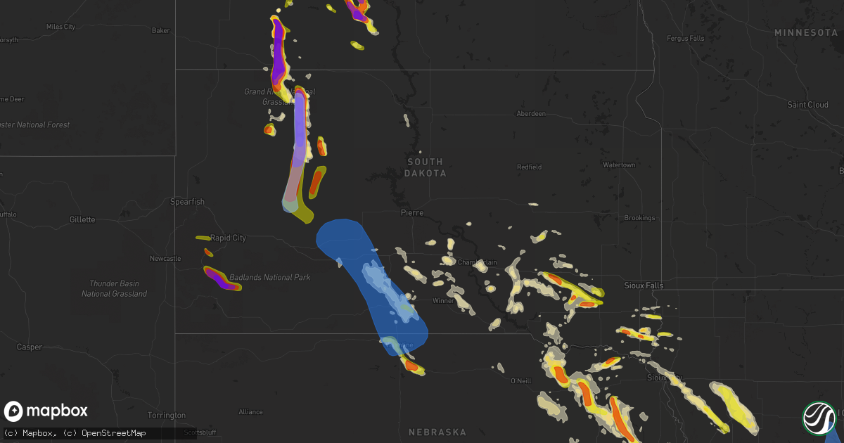
Hail Map in South Dakota on August 30, 2021
Get this storm
August 30 map
$229
one time, instant access
Download today. No call, no setup
Keep the $229
Bought the map and want the full workflow? Apply the entire $229 to a subscription within 7 days. None of it is wasted.
Every map, not just this one
This buys you this map. Subscription and you get every map we run, in the markets you choose from a few cities to whole states to nationwide. Plus real-time alerts the moment a storm fires.
Contact data
Name, contact info, occupancy, even credit band for addresses in the footprint. You go from where it hit to who to call.
Become the source they trust
Unlimited branding weather history reports on demand. You already have the documented answer ready for the property owner, and you are the one who showed up with it.
Property data and RoofTrace estimates
Pull up any address you have got, its value and the exact code rules for that jurisdiction, straight from One Click Code. Then RoofTrace estimates the squares, pitch, and roof value, priced the way you price.
Storm reports in South Dakota
South Dakota
| Date | Description |
|---|---|
| 08/30/20216:55 PM CDT | A local report indicates 1.75 inch wind near 10 SSE MEADOW |
| 08/30/20216:40 PM CDT | A local report indicates 74 MPH wind near 7 SSE MEADOW |
| 08/30/20216:35 PM CDT | A local report indicates 1.00 inch wind near 7 SW FAIRBURN |
| 08/30/20216:15 PM CDT | A local report indicates 2.75 inch wind near 4 ENE MEADOW |
| 08/30/20215:56 PM CDT | A local report indicates 1.00 inch wind near 8 SE CUSTER |
| 08/30/20215:48 PM CDT | A local report indicates 1.00 inch wind near 1 S CLAYTON |
| 08/30/20215:40 PM CDT | Lasted about 10 minutes |
| 08/30/20215:38 PM CDT | Hail up to the size of half dollars... And very little rainfall. |
| 08/30/20215:30 PM CDT | A lot of damage at the mt rushmore koa |
| 08/30/20215:27 PM CDT | Light rain and mostly small hail... But a few stones as big as golf balls. |
| 08/30/20215:25 PM CDT | A local report indicates 1.75 inch wind near 1 E HILL CITY |
| 08/30/20215:18 PM CDT | Picture via social media. Time estimated via radar... Location estimated via general location on social media. |
| 08/30/20215:14 PM CDT | Lasted 4 minutes |
| 08/30/20215:05 PM CDT | Delayed report. Golf ball up to tennis ball sized hail based on observation and windshield damage. Lasted 30 minutes. Strong winds but unsure of speed. Screens blown ou |
| 08/30/20215:03 PM CDT | Lots of variable sized hail and heavy rain... With biggest stones as big as quarters. |
| 08/30/20214:41 PM CDT | Quarter sized hail and heavy rain. |
| 08/30/20214:30 PM CDT | A local report indicates 1.00 inch wind near 2 ENE SILVER CITY |
| 08/30/20214:10 PM CDT | A local report indicates 1.00 inch wind near 5 SW NEMO |
| 08/30/20216:29 AM CDT | At 1129 PM MDT/1229 AM CDT/, severe thunderstorms were located along a line extending from 6 miles south of Van Metre to 5 miles north of George Town, moving southeast at 35 mph. HAZARD...60 mph wind gusts and penny size hail. SOURCE...Radar indicated. IMPACT...Expect damage to roofs, siding, and trees. Locations impacted include... White River, Parmelee, Long Valley, Norris, Belvidere, Cedar Butte, Black Pipe, Swift Bear, George Town, Horse Creek, Corn Creek and Intersection of Highway 73 and White River.This includes Interstate 90 in South Dakota between Mile Markers 156and 174. |
| 08/30/20216:19 AM CDT | At 1118 PM CDT, a severe thunderstorm was located near Woonsocket, or 18 miles south of Huron, moving northeast at 20 mph. HAZARD...60 mph wind gusts and half dollar size hail. SOURCE...Radar indicated. IMPACT...Hail damage to vehicles is expected. Expect wind damage to roofs, siding, and trees. This severe thunderstorm will remain over mainly rural areas of northwestern Sanborn, south central Beadle and east central Jerauld Counties. |
| 08/30/20216:14 AM CDT | At 1113 PM CDT, a severe thunderstorm was located near Joe Creek Rec Area, or 8 miles west of Lower Brule, moving north at 15 mph. HAZARD...60 mph wind gusts and quarter size hail. SOURCE...Radar indicated. IMPACT...Hail damage to vehicles is expected. Expect wind damage to roofs, siding, and trees. This severe thunderstorm will be near... Joe Creek Rec Area around 1130 PM CDT.Other locations in the path of this severe thunderstorm include WestBend Rec Area. |
| 08/30/20216:10 AM CDT | At 1109 PM CDT, a severe thunderstorm was located 8 miles southeast of Van Metre, or 15 miles north of Murdo, and is nearly stationary. HAZARD...60 mph wind gusts and quarter size hail. SOURCE...Radar indicated. IMPACT...Hail damage to vehicles is expected. Expect wind damage to roofs, siding, and trees. This severe thunderstorm will remain over mainly rural areas of north central Jones County. |
| 08/30/20215:29 AM CDT | At 1028 PM CDT, a severe thunderstorm was located 7 miles west of Valentine, moving southeast at 15 mph. HAZARD...Golf ball size hail and 60 mph wind gusts. SOURCE...Radar indicated. IMPACT...People and animals outdoors will be injured. Expect hail damage to roofs, siding, windows, and vehicles. Expect wind damage to roofs, siding, and trees. Locations impacted include... Valentine, Crookston, Highway 97 crossing the Niobrara River and Schlagel Creek State Wildlife Management Area.This includes the following highways... Highway 20 between mile markers 182 and 205. Highway 97 between mile markers 131 and 141. Highway 83 between mile markers 197 and 222. Highway 12 between mile markers 1 and 13. |
| 08/30/20214:47 AM CDT | At 947 PM CDT, a severe thunderstorm was located 8 miles west of Valentine, moving east at 15 mph. HAZARD...60 mph wind gusts and quarter size hail. SOURCE...Radar indicated. IMPACT...Hail damage to vehicles is expected. Expect wind damage to roofs, siding, and trees. Locations impacted include... Valentine, Crookston and Highway 97 crossing the Niobrara River. This includes the following highways... Highway 20 between mile markers 181 and 210. Highway 97 between mile markers 131 and 141. Highway 83 between mile markers 204 and 222. Highway 12 between mile markers 1 and 12. |
| 08/30/20214:26 AM CDT | At 926 PM MDT, a severe thunderstorm was located 12 miles northeast of Creighton, or 28 miles northwest of Philip, moving southeast at 25 mph. HAZARD...Quarter size hail. SOURCE...Radar indicated. IMPACT...Damage to vehicles is expected. Locations impacted include... Grindstone, Creighton and Grindstone Butte. This includes Interstate 90 in South Dakota between Mile Markers 101and 103. |
| 08/30/20214:08 AM CDT | At 908 PM MDT, a severe thunderstorm was located 9 miles southeast of Date, or 30 miles northwest of Faith, moving south at 15 mph. HAZARD...Ping pong ball size hail and 60 mph wind gusts. SOURCE...Radar indicated. IMPACT...People and animals outdoors will be injured. Expect hail damage to roofs, siding, windows, and vehicles. Expect wind damage to roofs, siding, and trees. Locations impacted include... Maurine. |
| 08/30/20213:46 AM CDT | At 846 PM MDT, a severe thunderstorm was located 3 miles northeast of Bridger, or 31 miles south of Faith, moving south at 15 mph. HAZARD...Golf ball size hail and 60 mph wind gusts. SOURCE...Radar indicated. IMPACT...People and animals outdoors will be injured. Expect hail damage to roofs, siding, windows, and vehicles. Expect wind damage to roofs, siding, and trees. This severe thunderstorm will be near... Bridger around 900 PM MDT. |
| 08/30/20213:40 AM CDT | At 840 PM MDT, a severe thunderstorm was located near Red Elm, or 9 miles west of Dupree, moving south at 10 mph. HAZARD...60 mph wind gusts and quarter size hail. SOURCE...Radar indicated. IMPACT...Hail damage to vehicles is expected. Expect wind damage to roofs, siding, and trees. This severe thunderstorm will be near... Red Elm around 900 PM MDT. |
| 08/30/20213:30 AM CDT | At 829 PM MDT, a severe thunderstorm was located 4 miles southwest of Plainview, or 32 miles south of Faith, moving south at 20 mph. HAZARD...Golf ball size hail and 60 mph wind gusts. SOURCE...Radar indicated. IMPACT...People and animals outdoors will be injured. Expect hail damage to roofs, siding, windows, and vehicles. Expect wind damage to roofs, siding, and trees. Locations impacted include... Creighton. |
| 08/30/20213:15 AM CDT | Delayed report. Power out for about three hours. Also two inches of rainfall. Time estimated from radar. |
| 08/30/20212:57 AM CDT | At 757 PM CDT, a severe thunderstorm was located near Dolton, or 14 miles west of Parker, moving east at 30 mph. HAZARD...60 mph wind gusts and quarter size hail. SOURCE...Radar indicated. IMPACT...Hail damage to vehicles is expected. Expect wind damage to roofs, siding, and trees. This severe thunderstorm will be near... Freeman around 800 PM CDT. Marion and Monroe around 815 PM CDT. Parker around 830 PM CDT. Hurley around 840 PM CDT. |
| 08/30/20212:41 AM CDT | At 741 PM MDT, severe thunderstorms were located along a line extending from 5 miles east of Red Scaffold to 9 miles southwest of Durkee Lake, moving south at 15 mph. HAZARD...Two inch hail and 70 mph wind gusts. SOURCE...Satellite and lightning indicated. IMPACT...People and animals outdoors will be injured. Expect hail damage to roofs, siding, windows, and vehicles. Expect considerable tree damage. Wind damage is also likely to mobile homes, roofs, and outbuildings. Severe thunderstorms will be near... Red Scaffold around 750 PM MDT.Other locations in the path of these severe thunderstorms includeTakini, Marcus, Plainview and Bridger. |
| 08/30/20212:29 AM CDT | At 728 PM CDT, a severe thunderstorm was located near Union Grove State Park, or 7 miles south of Beresford, moving east at 25 mph. HAZARD...60 mph wind gusts and quarter size hail. SOURCE...Radar indicated. IMPACT...Hail damage to vehicles is expected. Expect wind damage to roofs, siding, and trees. This severe thunderstorm will be near... Alcester around 745 PM CDT. Akron around 805 PM CDT.Other locations impacted by this severe thunderstorm includeChatsworth. |
| 08/30/20212:15 AM CDT | Delayed report. Power out for about three hours. Also two inches of rainfall. Time estimated from radar. |
| 08/30/20211:56 AM CDT | At 655 PM MDT, a severe thunderstorm was located 8 miles east of Lodgepole, or 16 miles southeast of Hettinger, moving south at 15 mph. HAZARD...Golf ball size hail and 60 mph wind gusts. SOURCE...Radar indicated. IMPACT...People and animals outdoors will be injured. Expect hail damage to roofs, siding, windows, and vehicles. Expect wind damage to roofs, siding, and trees. Locations impacted include... Bison. |
| 08/30/20211:50 AM CDT | A local report indicates 63 MPH wind near 15 SSE MISSION |
| 08/30/20211:45 AM CDT | A local report indicates 84 MPH wind near 9 ENE BELVIDERE |
| 08/30/20211:42 AM CDT | At 641 PM MDT, a severe thunderstorm was located 3 miles south of Arrow Head Buttes, or 7 miles north of Faith, moving south at 25 mph. THIS IS A DESTRUCTIVE STORM FOR FAITH. HAZARD...Three inch hail and 70 mph wind gusts. SOURCE...Radar indicated. IMPACT...People and animals outdoors will be severely injured. Expect shattered windows, extensive damage to roofs, siding, and vehicles. This severe thunderstorm will be near... Faith around 700 PM MDT.Other locations in the path of this severe thunderstorm includeDurkee Lake. |
| 08/30/20211:35 AM CDT | A local report indicates 67 MPH wind near 9 ENE BELVIDERE |
| 08/30/202112:59 AM CDT | At 558 PM CDT, a severe thunderstorm was located near Clayton, or 20 miles east of Parkston, moving southeast at 25 mph. HAZARD...60 mph wind gusts and quarter size hail. SOURCE...Public reported quarter size hail 1 mile south of Clayton at 548 PM. IMPACT...Hail damage to vehicles is expected. Expect wind damage to roofs, siding, and trees. Locations impacted include... Freeman and Hurley. |
| 08/30/202112:50 AM CDT | At 550 PM MDT, a severe thunderstorm was located 4 miles northeast of Buffalo Gap, or 13 miles northeast of Hot Springs, moving southeast at 15 mph. HAZARD...Tennis ball size hail and 60 mph wind gusts. SOURCE...Radar indicated. IMPACT...People and animals outdoors will be injured. Expect hail damage to roofs, siding, windows, and vehicles. Expect wind damage to roofs, siding, and trees. Locations impacted include... Oral. |
| 08/30/202112:45 AM CDT | At 542 PM MDT, a severe thunderstorm was located 10 miles east of Chance, or 23 miles north of Faith, moving south at 20 mph. THIS IS A DESTRUCTIVE STORM FOR USTA, IRON LIGHTNING, AND ARROW HEAD BUTTES. HAZARD...Three inch hail and 60 mph wind gusts. SOURCE...Radar indicated. IMPACT...People and animals outdoors will be severely injured. Expect shattered windows, extensive damage to roofs, siding, and vehicles. Locations impacted include... Usta, Arrow Head Buttes, Faith and Durkee Lake. |
| 08/30/202112:40 AM CDT | A local report indicates 72 MPH wind near 9 ENE BELVIDERE |
| 08/30/202112:30 AM CDT | At 529 PM CDT, a severe thunderstorm was located near Milltown, or 12 miles northeast of Parkston, moving southeast at 25 mph. HAZARD...60 mph wind gusts and half dollar size hail. SOURCE...Radar indicated. IMPACT...Hail damage to vehicles is expected. Expect wind damage to roofs, siding, and trees. This severe thunderstorm will be near... Clayton around 545 PM CDT. |
| 08/30/202112:25 AM CDT | A local report indicates 65 MPH wind near 1 NE MIDLAND |
| 08/30/202112:25 AM CDT | At 525 PM CDT, a severe thunderstorm was located near Freeman, or 20 miles west of Parker, moving east at 20 mph. HAZARD...60 mph wind gusts and quarter size hail. SOURCE...Radar indicated. IMPACT...Hail damage to vehicles is expected. Expect wind damage to roofs, siding, and trees. This severe thunderstorm will be near... Freeman around 545 PM CDT. |
| 08/30/202112:08 AM CDT | Heavy rain and hail up to the size of quarters. |
| 08/30/202112:06 AM CDT | At 503 PM MDT, a severe thunderstorm was located 7 miles east of Meadow, or 27 miles south of Lemmon, moving south at 10 mph. THIS IS A DESTRUCTIVE STORM FOR LOCATIONS BETWEEN MEADOW AND GLAD VALLEY. HAZARD...Baseball size hail and 60 mph wind gusts. SOURCE...Radar indicated. IMPACT...People and animals outdoors will be severely injured. Expect shattered windows, extensive damage to roofs, siding, and vehicles. This severe thunderstorm will remain over mainly rural areas of northwestern Ziebach and east central Perkins Counties between Meadow and Glad Valley. This includes Highway 20 between Coal Springs and Glad Valley. |
| 08/29/202111:58 PM CDT | At 458 PM MDT, a severe thunderstorm was located over southern Custer State Park, or 9 miles southeast of Custer, moving southeast at 10 mph. HAZARD...Two inch hail. SOURCE...Radar indicated. IMPACT...People and animals outdoors will be injured. Expect damage to roofs, siding, windows, and vehicles. This severe thunderstorm will be near... Buffalo Corrals around 515 PM MDT. |
| 08/29/202111:44 PM CDT | At 444 PM MDT, a severe thunderstorm was located near Shambo Ranch, or 27 miles southeast of Lemmon, moving east at 30 mph. HAZARD...Ping pong ball size hail and 60 mph wind gusts. SOURCE...Radar indicated. IMPACT...People and animals outdoors will be injured. Expect hail damage to roofs, siding, windows, and vehicles. Expect wind damage to roofs, siding, and trees. This severe thunderstorm will remain over mainly rural areas of southwestern Corson County. |
| 08/29/202111:29 PM CDT | At 428 PM MDT, a severe thunderstorm was located 6 miles southeast of Shadehill, or 17 miles south of Lemmon, and is nearly stationary. HAZARD...Tennis ball size hail and 60 mph wind gusts. SOURCE...Radar indicated. IMPACT...People and animals outdoors will be injured. Expect hail damage to roofs, siding, windows, and vehicles. Expect wind damage to roofs, siding, and trees. This severe thunderstorm will remain over mainly rural areas of northeastern Perkins County to the east and southeast of Shadehill Reservoir. |
| 08/29/202111:19 PM CDT | At 419 PM CDT, a severe thunderstorm was located near Mount Vernon, or 10 miles southwest of Mitchell, moving east at 20 mph. HAZARD...60 mph wind gusts and half dollar size hail. SOURCE...Radar indicated. IMPACT...Hail damage to vehicles is expected. Expect wind damage to roofs, siding, and trees. Locations impacted include... Ethan and Dimock. |
| 08/29/202111:09 PM CDT | At 408 PM MDT, a severe thunderstorm was located over Palmer Gulch Resort, or near Hill City, moving southeast at 15 mph. HAZARD...Quarter size hail. SOURCE...Radar indicated. IMPACT...Damage to vehicles is expected. This severe thunderstorm will be near... Keystone Wye and Custer State Park around 415 PM MDT. Rockerville, Mount Rushmore National Memorial and Horse Thief Lake around 420 PM MDT. Keystone around 425 PM MDT.Other locations in the path of this severe thunderstorm includeHayward, Black Hills Playhouse, Center Lake, Stockade Lake, LegionLake, Mount Coolidge and State Game Lodge. |
| 08/29/202111:03 PM CDT | 50-60 mph winds |
| 08/29/202110:54 PM CDT | At 353 PM MDT, a severe thunderstorm was located 11 miles northwest of Shambo Ranch, or 20 miles southeast of Lemmon, moving east at 25 mph. HAZARD...60 mph wind gusts and quarter size hail. SOURCE...Radar indicated. IMPACT...Hail damage to vehicles is expected. Expect wind damage to roofs, siding, and trees. This severe thunderstorm will remain over mainly rural areas of southwestern Corson County. |
| 08/29/202110:34 PM CDT | At 334 PM MDT, a severe thunderstorm was located 5 miles southeast of Shadehill, or 15 miles south of Lemmon, moving south at 10 mph. HAZARD...Ping pong ball size hail and 60 mph wind gusts. SOURCE...Radar indicated. IMPACT...People and animals outdoors will be injured. Expect hail damage to roofs, siding, windows, and vehicles. Expect wind damage to roofs, siding, and trees. Locations impacted include... Meadow. |
| 08/29/202110:03 PM CDT | 50-60 mpn winds |
| 08/29/20219:59 PM CDT | At 259 PM MDT, a severe thunderstorm was located near Silver City, or 11 miles north of Hill City, moving southeast at 15 mph. HAZARD...Quarter size hail. SOURCE...Satellite and lightning indicated. IMPACT...Damage to vehicles is expected. This severe thunderstorm will be near... Silver City and Pactola Reservoir around 310 PM MDT.Other locations in the path of this severe thunderstorm includeJohnson Siding, Hisega and Sheridan Lake.This includes Interstate 90 in South Dakota between Mile Markers 47and 56. |
| 08/29/20219:50 PM CDT | Marble with a few quarter size hail. |
| 08/29/20219:40 PM CDT | A local report indicates 1.00 inch wind near 7 SSW PLAINVIEW |
| 08/29/20219:00 PM CDT | A local report indicates 1.75 inch wind near 1 WNW RED SCAFFOLD |
| 08/29/20217:58 PM CDT | Corrects previous hail report from 6 s bridgewater. Mostly pea sized hail... But a few quarter sized stones... And heavy rain. |
| 08/29/20217:56 PM CDT | Mostly pea sized hail... But a few quarter sized stones... And heavy rain. |
| 08/29/20217:56 PM CDT | Delayed report. Hail fell for 20 minutes. Strong winds but unsure of speed. Damage to vehicles and shop. Start time estimated from radar. |
| 08/29/20217:55 PM CDT | A local report indicates 2.00 inch wind near 1 N FAITH |
| 08/29/20217:47 PM CDT | A local report indicates 68 MPH wind near 1 NNE FAITH |
| 08/29/20217:40 PM CDT | Delayed report. Winds at least 50 mph. Window and vehicle damage due to wind-driven hail. Time estimated from radar. |
| 08/29/20217:35 PM CDT | A local report indicates 1.75 inch wind near 6 SW WHITE BUTTE |
| 08/29/20217:32 PM CDT | A local report indicates 1.75 inch wind near 6 S BERESFORD |
| 08/29/20217:05 PM CDT | A local report indicates 1.00 inch wind near 7 SSE FAIRBURN |
All States Impacted by Hail Map on August 30, 2021
Cities Impacted by Hail Map on August 30, 2021
- Randolph, NE
- Carroll, NE
- Hoskins, NE
- Danville, IN
- Coatesville, IN
- Parkston, SD
- Syracuse, NE
- Avoca, NE
- Weeping Water, NE
- Alvo, NE
- Elmwood, NE
- Dunbar, NE
- Unadilla, NE
- Otoe, NE
- Hiawatha, KS
- Hartington, NE
- Niobrara, NE
- Lyerly, GA
- Rome, GA
- Solen, ND
- Center, ND
- New Salem, ND
- Beulah, ND
- Saint Anthony, ND
- Almont, ND
- Hazen, ND
- Flasher, ND
- Mandan, ND
- Meadow, SD
- Geddes, SD
- Platte, SD
- Waterloo, NE
- Yutan, NE
- Newman Grove, NE
- Saint Edward, NE
- Albion, NE
- Ethan, SD
- Mission, SD
- Nehawka, NE
- Plattsmouth, NE
- Louisville, NE
- Stanton, ND
- Lemmon, SD
- Hettinger, ND
- Corsica, SD
- Mount Vernon, SD
- Stickney, SD
- Mitchell, SD
- Canton, SD
- Inwood, IA
- Volin, SD
- Hooper, NE
- Fremont, NE
- Ames, NE
- North Bend, NE
- Wagner, SD
- Avon, SD
- Dante, SD
- Deloit, IA
- Cushing, IA
- Kiron, IA
- Manning, IA
- Holstein, IA
- Templeton, IA
- Schleswig, IA
- Manilla, IA
- Denison, IA
- Odebolt, IA
- Vail, IA
- Battle Creek, IA
- Westside, IA
- Arthur, IA
- Arcadia, IA
- Ida Grove, IA
- Omaha, NE
- Murray, NE
- Cedar Creek, NE
- Springfield, NE
- Elkhorn, NE
- Ashland, NE
- Gretna, NE
- Witten, SD
- Ideal, SD
- Windsor, VA
- Suffolk, VA
- Bison, SD
- Waverly, NE
- Greenwood, NE
- Verdigre, NE
- Wood Lake, NE
- Gaylesville, AL
- Eureka, MO
- Wildwood, MO
- Dupree, SD
- Creston, NE
- Columbus, NE
- Humphrey, NE
- Elgin, ND
- Carson, ND
- Stephan, SD
- Highmore, SD
- Lower Brule, SD
- Kennebec, SD
- Fairview, SD
- Faith, SD
- Harrison, SD
- Waterloo, IL
- Glen Ullin, ND
- Garrison, ND
- Vivian, SD
- Mott, ND
- Shelby, NE
- Osceola, NE
- Oakland, IA
- Wynot, NE
- Bloomfield, NE
- Crofton, NE
- Mount Solon, VA
- Osmond, NE
- Pierce, NE
- Winside, NE
- Petersburg, VA
- Hawarden, IA
- Rawlings, VA
- Fulton, SD
- Bronson, IA
- Ute, IA
- Mapleton, IA
- Hornick, IA
- Arion, IA
- Lawton, IA
- Moville, IA
- Rodney, IA
- Dow City, IA
- Smithland, IA
- Castana, IA
- Charter Oak, IA
- Dunlap, IA
- Sioux City, IA
- Anthon, IA
- Sergeant Bluff, IA
- Climbing Hill, IA
- Oto, IA
- Brodnax, VA
- La Crosse, VA
- Lynch, NE
- Unionville, MO
- Cayuga, IN
- Kingman, IN
- Hillsdale, IN
- Menno, SD
- Olivet, SD
- Freeman, SD
- Lenora, KS
- Creighton, NE
- Winnetoon, NE
- Brunswick, NE
- Hebron, ND
- Valentine, NE
- Ireton, IA
- Hancock, IA
- Griswold, IA
- Winner, SD
- Springfield, SD
- Roseglen, ND
- White River, SD
- Emery, SD
- Neola, IA
- Underwood, IA
- Stuart, NE
- Chamberlain, SD
- Pukwana, SD
- Oakdale, NE
- Dodge, NE
- Howells, NE
- Pilger, NE
- Wisner, NE
- Stanton, NE
- Wakonda, SD
- Artesian, SD
- Wausa, NE
- Norfolk, NE
- West Point, NE
- Wayne, NE
- Scribner, NE
- Plainview, NE
- Woonsocket, SD
- Ewing, NE
- Draper, SD
- Regent, ND
- Eagle Butte, SD
- Tyndall, SD
- Plankinton, SD
- Dimock, SD
- White Lake, SD
- Madison, NE
- Washburn, ND
- Sandy Hook, VA
- Goochland, VA
- Fordyce, NE
- Coleridge, NE
- Beresford, SD
- Alcester, SD
- Centerville, SD
- Vermillion, SD
- Worthing, SD
- Kimball, SD
- Clearwater, NE
- Neligh, NE
- Crookston, NE
- Akron, IA
- Irene, SD
- Elk Point, SD
- Roach, MO
- Clarkson, NE
- Nebraska City, NE
- Eagle, NE
- Lincoln, NE
- Murdock, NE
- Bonesteel, SD
- Tripp, SD
- Presho, SD
- Wood, SD
- Gregory, SD
- Dallas, SD
- Papillion, NE
- Memphis, NE
- Le Mars, IA
- Brunsville, IA
- Hamill, SD
- Alexandria, SD
- Emporia, VA
- Ryder, ND
- Blair, NE
- Shields, ND
- Herman, NE
- Fort Calhoun, NE
- Modale, IA
- Missouri Valley, IA
- Mclean, NE
- Crawfordsville, IN
- Burbank, SD
- Bridgewater, SD
- Calhoun, GA
- Adairsville, GA
- Saint Francis, KS
- Lodgepole, SD
- Bloomingdale, IN
- Montezuma, IN
- Rockville, IN
- Pacific, MO
- Saint Charles, SD
- Chesterfield, VA
- Center, NE
- Chestertown, MD
- Ashmore, IL
- Armour, SD
- Percival, IA
- Union, NE
- Gray, IA
- Audubon, IA
- Correctionville, IA
- Aspinwall, IA
- Carroll, IA
- Bancroft, NE
- Pender, NE
- Brayton, IA
- Anita, IA
- Exira, IA
- Robinson, KS
- Falls City, NE
- Rock Valley, IA
- Hudson, SD
- Sedona, AZ
- Reliance, SD
- Palmyra, NE
- Dutton, VA
- Gloucester, VA
- Murdo, SD
- Saint Helena, NE
- Georgetown, KY
- Wessington, SD
- Wessington Springs, SD
- Orchard, NE
- Tilden, NE
- Elgin, NE
- Thurman, IA
- Richardton, ND
- Malmo, NE
- Colon, NE
- Cedar Bluffs, NE
- Mead, NE
- Twentynine Palms, CA
- Alpena, SD
- Ladoga, IN
- Roachdale, IN
- Dawson, NE
- Verdon, NE
- Colome, SD
- Scotland, SD
- Hinton, IA
- Jefferson, SD
- Danbury, IA
- Defiance, IA
- North Sioux City, SD
- Westfield, IA
- Okaton, SD
- Parmelee, SD
- Gann Valley, SD
- Rising City, NE
- Minden, IA
- Council Bluffs, IA
- McClelland, IA
- Capron, VA
- Boykins, VA
- Saint Francis, SD
- Hamburg, IA
- Morse Bluff, NE
- Valley, NE
- Ceresco, NE
- Ithaca, NE
- South Bend, NE
- Wolsey, SD
- Belvidere, SD
- Lewis, IA
- Kadoka, SD
- Long Valley, SD
- Maurice, IA
- Novinger, MO
- Worthington, MO
- Livonia, MO
- Yale, VA
- Paris, IL
- Chrisman, IL
- Dana, IN
- Newsoms, VA
- Courtland, VA
- Craig, NE
- Tekamah, NE
- Snyder, NE
- Oneill, NE
- Meadow Grove, NE
- Beemer, NE
- Platte Center, NE
- Pacific Junction, IA
- Warner Springs, CA
- Atkinson, NE
- Sadieville, KY
- Marion, SD
- Moseley, VA
- Amelia Court House, VA
- Midlothian, VA
- Powhatan, VA
- Honey Creek, IA
- Crescent, IA
- Henderson, IA
- David City, NE
- Brainard, NE
- Nanjemoy, MD
- Letcher, SD
- Lennox, SD
- Danville, VA
- Ringgold, VA
- Charleston, IL
- Gettysburg, SD
- Walnut, IA
- Valmeyer, IL
- Richmond, VA
- Doon, IA
- Fulton, MO
- Lefor, ND
- Hill City, SD
- Rapid City, SD
- Milesville, SD
- Howes, SD
- Wall, SD
- Philip, SD
- Wasta, SD
- White Owl, SD
- Keystone, SD
- Custer, SD
- Fairburn, SD
- Buffalo Gap, SD
- Cherry Creek, SD
- Manley, NE
- Winslow, NE
- Arlington, NE
- Nickerson, NE
- Midland, SD
- Rosebud, SD
- Fort Pierre, SD
- Sparks, NE
- Springview, NE
- Norris, SD
- Des Moines, IA
- Prole, IA
- Van Meter, IA
- Johnston, IA
- Liberty Center, IA
- Urbandale, IA
- Luther, IA
- Indianola, IA
- Woodburn, IA
- Madrid, IA
- Osceola, IA
- Waukee, IA
- Granger, IA
- Winterset, IA
- Clive, IA
- Ankeny, IA
- Chariton, IA
- Martensdale, IA
- Saint Marys, IA
- Ackworth, IA
- Dallas Center, IA
- Carlisle, IA
- Norwalk, IA
- Boone, IA
- Saint Charles, IA
- New Virginia, IA
- Kelley, IA
- Windsor Heights, IA
- Cumming, IA
- Booneville, IA
- Woodward, IA
- Lacona, IA
- Williamson, IA
- Grimes, IA
- Milo, IA
- Adel, IA
- Bevington, IA
- Patterson, IA
- Polk City, IA
- Lucas, IA
- Truro, IA
- West Des Moines, IA


