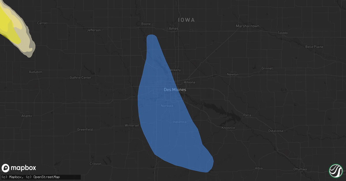
Hail Map in Des Moines, IA on August 30, 2021
Get this storm
August 30 map
$229
one time, instant access
Download today. No call, no setup
Keep the $229
Bought the map and want the full workflow? Apply the entire $229 to a subscription within 7 days. None of it is wasted.
Every map, not just this one
This buys you this map. Subscription and you get every map we run, in the markets you choose from a few cities to whole states to nationwide. Plus real-time alerts the moment a storm fires.
Contact data
Name, contact info, occupancy, even credit band for addresses in the footprint. You go from where it hit to who to call.
Become the source they trust
Unlimited branding weather history reports on demand. You already have the documented answer ready for the property owner, and you are the one who showed up with it.
Property data and RoofTrace estimates
Pull up any address you have got, its value and the exact code rules for that jurisdiction, straight from One Click Code. Then RoofTrace estimates the squares, pitch, and roof value, priced the way you price.
Storm reports in Des Moines, IA
Des Moines, IA
| Date | Description |
|---|---|
| 08/30/202111:58 AM CDT | A local report indicates 59 MPH wind near DES MOINES INT AIRPORT |
| 08/30/202112:17 AM CDT | Wires down near 55th and university. |
| 08/29/202111:58 PM CDT | Corrects previous tstm wnd gst report from des moines int airport |
| 08/29/202111:57 PM CDT | Tree down... Wires down. Time estimated from koax radar. |
| 08/29/202111:56 PM CDT | 12 inch diameter tree limb fell on a power line... Which caused a house fire. Multiple 5 to 6 inch diameter branches down in the area also. Time estimated. |
| 08/29/202111:51 PM CDT | Large tree down across the road. Time estimated from koax radar. |
All States Impacted by Hail Map on August 30, 2021
All Cities Impacted by Hail Map on August 30, 2021
- Randolph, NE
- Carroll, NE
- Hoskins, NE
- Danville, IN
- Coatesville, IN
- Parkston, SD
- Syracuse, NE
- Avoca, NE
- Weeping Water, NE
- Alvo, NE
- Elmwood, NE
- Dunbar, NE
- Unadilla, NE
- Otoe, NE
- Hiawatha, KS
- Hartington, NE
- Niobrara, NE
- Lyerly, GA
- Rome, GA
- Solen, ND
- Center, ND
- New Salem, ND
- Beulah, ND
- Saint Anthony, ND
- Almont, ND
- Hazen, ND
- Flasher, ND
- Mandan, ND
- Meadow, SD
- Geddes, SD
- Platte, SD
- Waterloo, NE
- Yutan, NE
- Newman Grove, NE
- Saint Edward, NE
- Albion, NE
- Ethan, SD
- Mission, SD
- Nehawka, NE
- Plattsmouth, NE
- Louisville, NE
- Stanton, ND
- Lemmon, SD
- Hettinger, ND
- Corsica, SD
- Mount Vernon, SD
- Stickney, SD
- Mitchell, SD
- Canton, SD
- Inwood, IA
- Volin, SD
- Hooper, NE
- Fremont, NE
- Ames, NE
- North Bend, NE
- Wagner, SD
- Avon, SD
- Dante, SD
- Deloit, IA
- Cushing, IA
- Kiron, IA
- Manning, IA
- Holstein, IA
- Templeton, IA
- Schleswig, IA
- Manilla, IA
- Denison, IA
- Odebolt, IA
- Vail, IA
- Battle Creek, IA
- Westside, IA
- Arthur, IA
- Arcadia, IA
- Ida Grove, IA
- Omaha, NE
- Murray, NE
- Cedar Creek, NE
- Springfield, NE
- Elkhorn, NE
- Ashland, NE
- Gretna, NE
- Witten, SD
- Ideal, SD
- Windsor, VA
- Suffolk, VA
- Bison, SD
- Waverly, NE
- Greenwood, NE
- Verdigre, NE
- Wood Lake, NE
- Gaylesville, AL
- Eureka, MO
- Wildwood, MO
- Dupree, SD
- Creston, NE
- Columbus, NE
- Humphrey, NE
- Elgin, ND
- Carson, ND
- Stephan, SD
- Highmore, SD
- Lower Brule, SD
- Kennebec, SD
- Fairview, SD
- Faith, SD
- Harrison, SD
- Waterloo, IL
- Glen Ullin, ND
- Garrison, ND
- Vivian, SD
- Mott, ND
- Shelby, NE
- Osceola, NE
- Oakland, IA
- Wynot, NE
- Bloomfield, NE
- Crofton, NE
- Mount Solon, VA
- Osmond, NE
- Pierce, NE
- Winside, NE
- Petersburg, VA
- Hawarden, IA
- Rawlings, VA
- Fulton, SD
- Bronson, IA
- Ute, IA
- Mapleton, IA
- Hornick, IA
- Arion, IA
- Lawton, IA
- Moville, IA
- Rodney, IA
- Dow City, IA
- Smithland, IA
- Castana, IA
- Charter Oak, IA
- Dunlap, IA
- Sioux City, IA
- Anthon, IA
- Sergeant Bluff, IA
- Climbing Hill, IA
- Oto, IA
- Brodnax, VA
- La Crosse, VA
- Lynch, NE
- Unionville, MO
- Cayuga, IN
- Kingman, IN
- Hillsdale, IN
- Menno, SD
- Olivet, SD
- Freeman, SD
- Lenora, KS
- Creighton, NE
- Winnetoon, NE
- Brunswick, NE
- Hebron, ND
- Valentine, NE
- Ireton, IA
- Hancock, IA
- Griswold, IA
- Winner, SD
- Springfield, SD
- Roseglen, ND
- White River, SD
- Emery, SD
- Neola, IA
- Underwood, IA
- Stuart, NE
- Chamberlain, SD
- Pukwana, SD
- Oakdale, NE
- Dodge, NE
- Howells, NE
- Pilger, NE
- Wisner, NE
- Stanton, NE
- Wakonda, SD
- Artesian, SD
- Wausa, NE
- Norfolk, NE
- West Point, NE
- Wayne, NE
- Scribner, NE
- Plainview, NE
- Woonsocket, SD
- Ewing, NE
- Draper, SD
- Regent, ND
- Eagle Butte, SD
- Tyndall, SD
- Plankinton, SD
- Dimock, SD
- White Lake, SD
- Madison, NE
- Washburn, ND
- Sandy Hook, VA
- Goochland, VA
- Fordyce, NE
- Coleridge, NE
- Beresford, SD
- Alcester, SD
- Centerville, SD
- Vermillion, SD
- Worthing, SD
- Kimball, SD
- Clearwater, NE
- Neligh, NE
- Crookston, NE
- Akron, IA
- Irene, SD
- Elk Point, SD
- Roach, MO
- Clarkson, NE
- Nebraska City, NE
- Eagle, NE
- Lincoln, NE
- Murdock, NE
- Bonesteel, SD
- Tripp, SD
- Presho, SD
- Wood, SD
- Gregory, SD
- Dallas, SD
- Papillion, NE
- Memphis, NE
- Le Mars, IA
- Brunsville, IA
- Hamill, SD
- Alexandria, SD
- Emporia, VA
- Ryder, ND
- Blair, NE
- Shields, ND
- Herman, NE
- Fort Calhoun, NE
- Modale, IA
- Missouri Valley, IA
- Mclean, NE
- Crawfordsville, IN
- Burbank, SD
- Bridgewater, SD
- Calhoun, GA
- Adairsville, GA
- Saint Francis, KS
- Lodgepole, SD
- Bloomingdale, IN
- Montezuma, IN
- Rockville, IN
- Pacific, MO
- Saint Charles, SD
- Chesterfield, VA
- Center, NE
- Chestertown, MD
- Ashmore, IL
- Armour, SD
- Percival, IA
- Union, NE
- Gray, IA
- Audubon, IA
- Correctionville, IA
- Aspinwall, IA
- Carroll, IA
- Bancroft, NE
- Pender, NE
- Brayton, IA
- Anita, IA
- Exira, IA
- Robinson, KS
- Falls City, NE
- Rock Valley, IA
- Hudson, SD
- Sedona, AZ
- Reliance, SD
- Palmyra, NE
- Dutton, VA
- Gloucester, VA
- Murdo, SD
- Saint Helena, NE
- Georgetown, KY
- Wessington, SD
- Wessington Springs, SD
- Orchard, NE
- Tilden, NE
- Elgin, NE
- Thurman, IA
- Richardton, ND
- Malmo, NE
- Colon, NE
- Cedar Bluffs, NE
- Mead, NE
- Twentynine Palms, CA
- Alpena, SD
- Ladoga, IN
- Roachdale, IN
- Dawson, NE
- Verdon, NE
- Colome, SD
- Scotland, SD
- Hinton, IA
- Jefferson, SD
- Danbury, IA
- Defiance, IA
- North Sioux City, SD
- Westfield, IA
- Okaton, SD
- Parmelee, SD
- Gann Valley, SD
- Rising City, NE
- Minden, IA
- Council Bluffs, IA
- McClelland, IA
- Capron, VA
- Boykins, VA
- Saint Francis, SD
- Hamburg, IA
- Morse Bluff, NE
- Valley, NE
- Ceresco, NE
- Ithaca, NE
- South Bend, NE
- Wolsey, SD
- Belvidere, SD
- Lewis, IA
- Kadoka, SD
- Long Valley, SD
- Maurice, IA
- Novinger, MO
- Worthington, MO
- Livonia, MO
- Yale, VA
- Paris, IL
- Chrisman, IL
- Dana, IN
- Newsoms, VA
- Courtland, VA
- Craig, NE
- Tekamah, NE
- Snyder, NE
- Oneill, NE
- Meadow Grove, NE
- Beemer, NE
- Platte Center, NE
- Pacific Junction, IA
- Warner Springs, CA
- Atkinson, NE
- Sadieville, KY
- Marion, SD
- Moseley, VA
- Amelia Court House, VA
- Midlothian, VA
- Powhatan, VA
- Honey Creek, IA
- Crescent, IA
- Henderson, IA
- David City, NE
- Brainard, NE
- Nanjemoy, MD
- Letcher, SD
- Lennox, SD
- Danville, VA
- Ringgold, VA
- Charleston, IL
- Gettysburg, SD
- Walnut, IA
- Valmeyer, IL
- Richmond, VA
- Doon, IA
- Fulton, MO
- Lefor, ND
- Hill City, SD
- Rapid City, SD
- Milesville, SD
- Howes, SD
- Wall, SD
- Philip, SD
- Wasta, SD
- White Owl, SD
- Keystone, SD
- Custer, SD
- Fairburn, SD
- Buffalo Gap, SD
- Cherry Creek, SD
- Manley, NE
- Winslow, NE
- Arlington, NE
- Nickerson, NE
- Midland, SD
- Rosebud, SD
- Fort Pierre, SD
- Sparks, NE
- Springview, NE
- Norris, SD
- Des Moines, IA
- Prole, IA
- Van Meter, IA
- Johnston, IA
- Liberty Center, IA
- Urbandale, IA
- Luther, IA
- Indianola, IA
- Woodburn, IA
- Madrid, IA
- Osceola, IA
- Waukee, IA
- Granger, IA
- Winterset, IA
- Clive, IA
- Ankeny, IA
- Chariton, IA
- Martensdale, IA
- Saint Marys, IA
- Ackworth, IA
- Dallas Center, IA
- Carlisle, IA
- Norwalk, IA
- Boone, IA
- Saint Charles, IA
- New Virginia, IA
- Kelley, IA
- Windsor Heights, IA
- Cumming, IA
- Booneville, IA
- Woodward, IA
- Lacona, IA
- Williamson, IA
- Grimes, IA
- Milo, IA
- Adel, IA
- Bevington, IA
- Patterson, IA
- Polk City, IA
- Lucas, IA
- Truro, IA
- West Des Moines, IA


