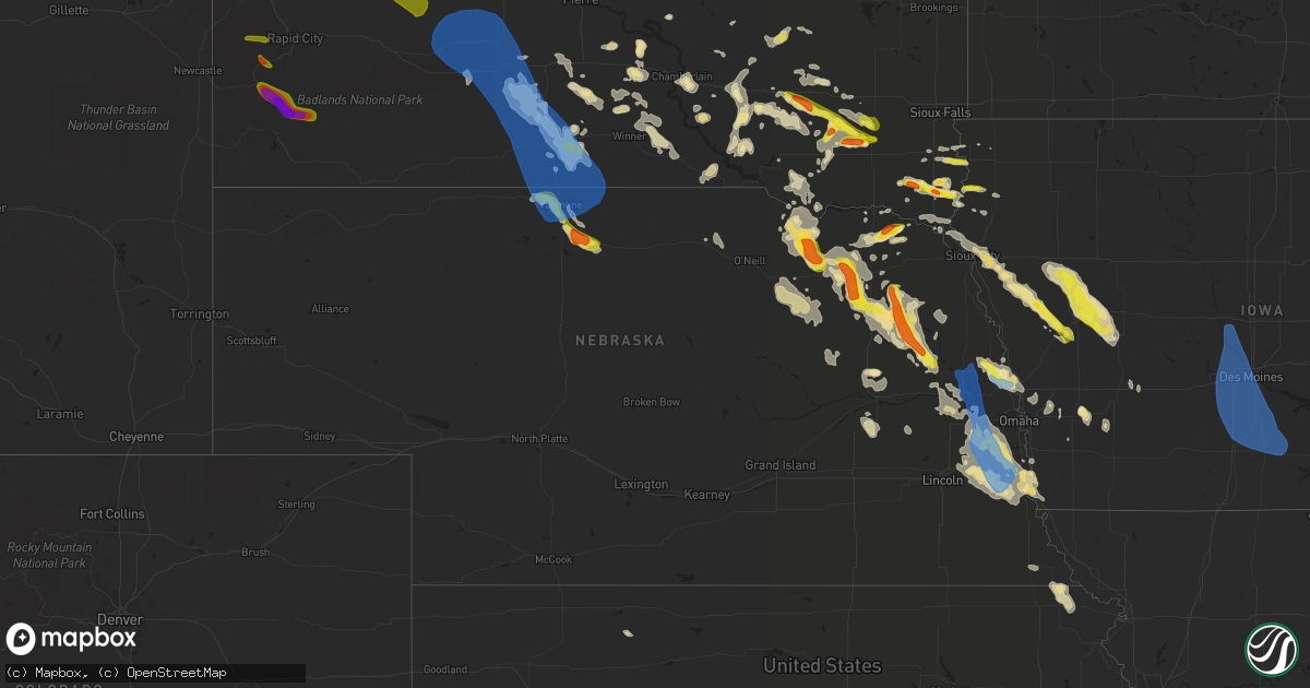
Hail Map in Nebraska on August 30, 2021
Get this storm
August 30 map
$229
one time, instant access
Download today. No call, no setup
Keep the $229
Bought the map and want the full workflow? Apply the entire $229 to a subscription within 7 days. None of it is wasted.
Every map, not just this one
This buys you this map. Subscription and you get every map we run, in the markets you choose from a few cities to whole states to nationwide. Plus real-time alerts the moment a storm fires.
Contact data
Name, contact info, occupancy, even credit band for addresses in the footprint. You go from where it hit to who to call.
Become the source they trust
Unlimited branding weather history reports on demand. You already have the documented answer ready for the property owner, and you are the one who showed up with it.
Property data and RoofTrace estimates
Pull up any address you have got, its value and the exact code rules for that jurisdiction, straight from One Click Code. Then RoofTrace estimates the squares, pitch, and roof value, priced the way you price.
Storm reports in Nebraska
Nebraska
| Date | Description |
|---|---|
| 08/30/20216:00 PM CDT | Delayed report of several large tree branches down ranging from 2 to 12 inches in diameter. Also reported at least 5 windows broke out of vehicles due to blowing gravel |
| 08/30/20216:55 AM CDT | At 1154 PM CDT, a severe thunderstorm was located 11 miles northeast of Valentine National Wildlife Refuge, or 18 miles south of Valentine, moving southeast at 20 mph. HAZARD...60 mph wind gusts and quarter size hail. SOURCE...Radar indicated. IMPACT...Hail damage to vehicles is expected. Expect wind damage to roofs, siding, and trees. Locations impacted include... Johnstown and Wood Lake. This includes the following highways... Highway 20 between mile markers 208 and 239. Highway 83 between mile markers 193 and 199. |
| 08/30/20216:54 AM CDT | At 1153 PM CDT, a severe thunderstorm was located over Pierce, or 10 miles northwest of Norfolk, moving southeast at 20 mph. HAZARD...60 mph wind gusts and quarter size hail. SOURCE...Radar indicated. IMPACT...Hail damage to vehicles is expected. Expect wind damage to roofs, siding, and trees. Locations impacted include... Hadar, Norfolk and Hoskins. |
| 08/30/20216:42 AM CDT | At 1142 PM CDT, a severe thunderstorm was located 5 miles southwest of Wisner, or 23 miles east of Norfolk, moving southeast at 30 mph. HAZARD...Ping pong ball size hail and 60 mph wind gusts. SOURCE...Radar indicated. IMPACT...People and animals outdoors will be injured. Expect hail damage to roofs, siding, windows, and vehicles. Expect wind damage to roofs, siding, and trees. This severe thunderstorm will be near... Beemer around 1155 PM CDT.Other locations in the path of this severe thunderstorm include WestPoint. |
| 08/30/20216:35 AM CDT | At 1134 PM CDT, a severe thunderstorm was located near Verdigre, or 28 miles east of O'Neill, moving southeast at 20 mph. HAZARD...60 mph wind gusts and quarter size hail. SOURCE...Radar indicated. IMPACT...Hail damage to vehicles is expected. Expect wind damage to roofs, siding, and trees. This severe thunderstorm will be near... Verdigre around 1145 PM CDT.Other locations in the path of this severe thunderstorm includeCreighton. |
| 08/30/20216:23 AM CDT | Delayed entry. |
| 08/30/20216:11 AM CDT | At 1110 PM CDT, a severe thunderstorm was located 7 miles south of Valentine, moving southeast at 15 mph. HAZARD...Golf ball size hail and 60 mph wind gusts. SOURCE...Radar indicated. IMPACT...People and animals outdoors will be injured. Expect hail damage to roofs, siding, windows, and vehicles. Expect wind damage to roofs, siding, and trees. Locations impacted include... Valentine, Valentine National Wildlife Refuge, Highway 97 crossing the Niobrara River, Big Alkali Lake State Wildlife Management Area and Schlagel Creek State Wildlife Management Area.This includes the following highways... Highway 20 between mile markers 191 and 220. Highway 97 between mile markers 129 and 141. Highway 83 between mile markers 186 and 218. Highway 12 between mile markers 1 and 3. |
| 08/30/20216:06 AM CDT | At 1105 PM CDT, a severe thunderstorm was located over Osmond, or 22 miles northwest of Norfolk, moving southeast at 20 mph. HAZARD...Golf ball size hail and 60 mph wind gusts. SOURCE...Radar indicated. IMPACT...People and animals outdoors will be injured. Expect hail damage to roofs, siding, windows, and vehicles. Expect wind damage to roofs, siding, and trees. Locations impacted include... Pierce and Hadar. |
| 08/30/20216:01 AM CDT | At 1101 PM CDT, a severe thunderstorm was located over Winside, or 16 miles northeast of Norfolk, moving southeast at 20 mph. HAZARD...Golf ball size hail and 60 mph wind gusts. SOURCE...Radar indicated. IMPACT...People and animals outdoors will be injured. Expect hail damage to roofs, siding, windows, and vehicles. Expect wind damage to roofs, siding, and trees. Locations impacted include... Pilger. |
| 08/30/20215:54 AM CDT | At 1053 PM CDT, a severe thunderstorm was located west of Hartington, or 18 miles south of Yankton, moving east at 30 mph. HAZARD...60 mph wind gusts and quarter size hail. SOURCE...Radar indicated. IMPACT...Hail damage to vehicles is expected. Expect wind damage to roofs, siding, and trees. This severe thunderstorm will be near... Wynot around 1105 PM CDT. |
| 08/30/20215:31 AM CDT | At 1031 PM CDT, a severe thunderstorm was located over Carroll, or 19 miles northeast of Norfolk, moving southeast at 25 mph. HAZARD...60 mph wind gusts and quarter size hail. SOURCE...Radar indicated. IMPACT...Hail damage to vehicles is expected. Expect wind damage to roofs, siding, and trees. This severe thunderstorm will be near... Wayne around 1050 PM CDT.Other locations in the path of this severe thunderstorm includeWakefield. |
| 08/30/20215:29 AM CDT | At 1028 PM CDT, a severe thunderstorm was located 6 miles northwest of Osmond, or 30 miles south of Lewis And Clark State Recreation Area, moving southeast at 20 mph. HAZARD...60 mph wind gusts and half dollar size hail. SOURCE...Radar indicated. IMPACT...Hail damage to vehicles is expected. Expect wind damage to roofs, siding, and trees. This severe thunderstorm will be near... Osmond and Wausa around 1040 PM CDT.Other locations in the path of this severe thunderstorm includeRandolph. |
| 08/30/20212:10 AM CDT | Emergency manager relayed report of peak wind gusts near 60 mph in louisville. |
| 08/30/20211:45 AM CDT | A local report indicates 60 MPH wind near 4 N GRETNA |
| 08/30/20211:35 AM CDT | Peak wind gust of 58 mph was measured at the office. |
| 08/30/20211:33 AM CDT | A local report indicates 58 MPH wind near 1 WNW VALLEY |
| 08/30/20211:07 AM CDT | Trained spotter estimated peak wind gust of 70 to 80 mph. |
| 08/30/202112:43 AM CDT | Report from mping: quarter |
| 08/30/202112:40 AM CDT | Trained spotter sent in a picture of quarter size hail in hadar. |
| 08/30/202112:30 AM CDT | Power also out. |
| 08/30/202112:17 AM CDT | 8 foot diameter tree blown down... Which took out a utility pole and power line. |
| 08/30/202112:05 AM CDT | Corrects previous hail report from 8 se stanton. Public reported via social media golf ball sized hail. |
| 08/29/202111:50 PM CDT | Public reported via social tennis ball size hail. |
| 08/29/202111:45 PM CDT | Trained spotter reported golf ball sized hail in verdigre. |
| 08/29/202111:45 PM CDT | Emergency manager reported golf ball size hail. |
| 08/29/202111:42 PM CDT | A local report indicates 1.00 inch wind near 2 WNW PILGER |
| 08/29/202111:40 PM CDT | Public reported via social media 2.5 inch hail north of stanton. |
| 08/29/202111:25 PM CDT | Delayed report |
| 08/29/202111:15 PM CDT | A local report indicates 1.75 inch wind near 5 ENE FORDYCE |
| 08/29/202111:11 PM CDT | Public reported via social media tennis ball size hail. |
| 08/29/202111:03 PM CDT | Quarter sized hail. |
| 08/29/202111:00 PM CDT | Delayed report |
| 08/29/202110:58 PM CDT | Report from mping: half dollar |
| 08/29/202110:55 PM CDT | Public reported via social media 1.5 inch hail in pierce. |
| 08/29/202110:50 PM CDT | Public estimated quarter sized hail falling in osmond. |
| 08/29/202110:37 PM CDT | Trained spotter reported 1 inch hail. |
| 08/29/20219:50 PM CDT | Delayed report. Time estimated by radar. |
All States Impacted by Hail Map on August 30, 2021
Cities Impacted by Hail Map on August 30, 2021
- Randolph, NE
- Carroll, NE
- Hoskins, NE
- Danville, IN
- Coatesville, IN
- Parkston, SD
- Syracuse, NE
- Avoca, NE
- Weeping Water, NE
- Alvo, NE
- Elmwood, NE
- Dunbar, NE
- Unadilla, NE
- Otoe, NE
- Hiawatha, KS
- Hartington, NE
- Niobrara, NE
- Lyerly, GA
- Rome, GA
- Solen, ND
- Center, ND
- New Salem, ND
- Beulah, ND
- Saint Anthony, ND
- Almont, ND
- Hazen, ND
- Flasher, ND
- Mandan, ND
- Meadow, SD
- Geddes, SD
- Platte, SD
- Waterloo, NE
- Yutan, NE
- Newman Grove, NE
- Saint Edward, NE
- Albion, NE
- Ethan, SD
- Mission, SD
- Nehawka, NE
- Plattsmouth, NE
- Louisville, NE
- Stanton, ND
- Lemmon, SD
- Hettinger, ND
- Corsica, SD
- Mount Vernon, SD
- Stickney, SD
- Mitchell, SD
- Canton, SD
- Inwood, IA
- Volin, SD
- Hooper, NE
- Fremont, NE
- Ames, NE
- North Bend, NE
- Wagner, SD
- Avon, SD
- Dante, SD
- Deloit, IA
- Cushing, IA
- Kiron, IA
- Manning, IA
- Holstein, IA
- Templeton, IA
- Schleswig, IA
- Manilla, IA
- Denison, IA
- Odebolt, IA
- Vail, IA
- Battle Creek, IA
- Westside, IA
- Arthur, IA
- Arcadia, IA
- Ida Grove, IA
- Omaha, NE
- Murray, NE
- Cedar Creek, NE
- Springfield, NE
- Elkhorn, NE
- Ashland, NE
- Gretna, NE
- Witten, SD
- Ideal, SD
- Windsor, VA
- Suffolk, VA
- Bison, SD
- Waverly, NE
- Greenwood, NE
- Verdigre, NE
- Wood Lake, NE
- Gaylesville, AL
- Eureka, MO
- Wildwood, MO
- Dupree, SD
- Creston, NE
- Columbus, NE
- Humphrey, NE
- Elgin, ND
- Carson, ND
- Stephan, SD
- Highmore, SD
- Lower Brule, SD
- Kennebec, SD
- Fairview, SD
- Faith, SD
- Harrison, SD
- Waterloo, IL
- Glen Ullin, ND
- Garrison, ND
- Vivian, SD
- Mott, ND
- Shelby, NE
- Osceola, NE
- Oakland, IA
- Wynot, NE
- Bloomfield, NE
- Crofton, NE
- Mount Solon, VA
- Osmond, NE
- Pierce, NE
- Winside, NE
- Petersburg, VA
- Hawarden, IA
- Rawlings, VA
- Fulton, SD
- Bronson, IA
- Ute, IA
- Mapleton, IA
- Hornick, IA
- Arion, IA
- Lawton, IA
- Moville, IA
- Rodney, IA
- Dow City, IA
- Smithland, IA
- Castana, IA
- Charter Oak, IA
- Dunlap, IA
- Sioux City, IA
- Anthon, IA
- Sergeant Bluff, IA
- Climbing Hill, IA
- Oto, IA
- Brodnax, VA
- La Crosse, VA
- Lynch, NE
- Unionville, MO
- Cayuga, IN
- Kingman, IN
- Hillsdale, IN
- Menno, SD
- Olivet, SD
- Freeman, SD
- Lenora, KS
- Creighton, NE
- Winnetoon, NE
- Brunswick, NE
- Hebron, ND
- Valentine, NE
- Ireton, IA
- Hancock, IA
- Griswold, IA
- Winner, SD
- Springfield, SD
- Roseglen, ND
- White River, SD
- Emery, SD
- Neola, IA
- Underwood, IA
- Stuart, NE
- Chamberlain, SD
- Pukwana, SD
- Oakdale, NE
- Dodge, NE
- Howells, NE
- Pilger, NE
- Wisner, NE
- Stanton, NE
- Wakonda, SD
- Artesian, SD
- Wausa, NE
- Norfolk, NE
- West Point, NE
- Wayne, NE
- Scribner, NE
- Plainview, NE
- Woonsocket, SD
- Ewing, NE
- Draper, SD
- Regent, ND
- Eagle Butte, SD
- Tyndall, SD
- Plankinton, SD
- Dimock, SD
- White Lake, SD
- Madison, NE
- Washburn, ND
- Sandy Hook, VA
- Goochland, VA
- Fordyce, NE
- Coleridge, NE
- Beresford, SD
- Alcester, SD
- Centerville, SD
- Vermillion, SD
- Worthing, SD
- Kimball, SD
- Clearwater, NE
- Neligh, NE
- Crookston, NE
- Akron, IA
- Irene, SD
- Elk Point, SD
- Roach, MO
- Clarkson, NE
- Nebraska City, NE
- Eagle, NE
- Lincoln, NE
- Murdock, NE
- Bonesteel, SD
- Tripp, SD
- Presho, SD
- Wood, SD
- Gregory, SD
- Dallas, SD
- Papillion, NE
- Memphis, NE
- Le Mars, IA
- Brunsville, IA
- Hamill, SD
- Alexandria, SD
- Emporia, VA
- Ryder, ND
- Blair, NE
- Shields, ND
- Herman, NE
- Fort Calhoun, NE
- Modale, IA
- Missouri Valley, IA
- Mclean, NE
- Crawfordsville, IN
- Burbank, SD
- Bridgewater, SD
- Calhoun, GA
- Adairsville, GA
- Saint Francis, KS
- Lodgepole, SD
- Bloomingdale, IN
- Montezuma, IN
- Rockville, IN
- Pacific, MO
- Saint Charles, SD
- Chesterfield, VA
- Center, NE
- Chestertown, MD
- Ashmore, IL
- Armour, SD
- Percival, IA
- Union, NE
- Gray, IA
- Audubon, IA
- Correctionville, IA
- Aspinwall, IA
- Carroll, IA
- Bancroft, NE
- Pender, NE
- Brayton, IA
- Anita, IA
- Exira, IA
- Robinson, KS
- Falls City, NE
- Rock Valley, IA
- Hudson, SD
- Sedona, AZ
- Reliance, SD
- Palmyra, NE
- Dutton, VA
- Gloucester, VA
- Murdo, SD
- Saint Helena, NE
- Georgetown, KY
- Wessington, SD
- Wessington Springs, SD
- Orchard, NE
- Tilden, NE
- Elgin, NE
- Thurman, IA
- Richardton, ND
- Malmo, NE
- Colon, NE
- Cedar Bluffs, NE
- Mead, NE
- Twentynine Palms, CA
- Alpena, SD
- Ladoga, IN
- Roachdale, IN
- Dawson, NE
- Verdon, NE
- Colome, SD
- Scotland, SD
- Hinton, IA
- Jefferson, SD
- Danbury, IA
- Defiance, IA
- North Sioux City, SD
- Westfield, IA
- Okaton, SD
- Parmelee, SD
- Gann Valley, SD
- Rising City, NE
- Minden, IA
- Council Bluffs, IA
- McClelland, IA
- Capron, VA
- Boykins, VA
- Saint Francis, SD
- Hamburg, IA
- Morse Bluff, NE
- Valley, NE
- Ceresco, NE
- Ithaca, NE
- South Bend, NE
- Wolsey, SD
- Belvidere, SD
- Lewis, IA
- Kadoka, SD
- Long Valley, SD
- Maurice, IA
- Novinger, MO
- Worthington, MO
- Livonia, MO
- Yale, VA
- Paris, IL
- Chrisman, IL
- Dana, IN
- Newsoms, VA
- Courtland, VA
- Craig, NE
- Tekamah, NE
- Snyder, NE
- Oneill, NE
- Meadow Grove, NE
- Beemer, NE
- Platte Center, NE
- Pacific Junction, IA
- Warner Springs, CA
- Atkinson, NE
- Sadieville, KY
- Marion, SD
- Moseley, VA
- Amelia Court House, VA
- Midlothian, VA
- Powhatan, VA
- Honey Creek, IA
- Crescent, IA
- Henderson, IA
- David City, NE
- Brainard, NE
- Nanjemoy, MD
- Letcher, SD
- Lennox, SD
- Danville, VA
- Ringgold, VA
- Charleston, IL
- Gettysburg, SD
- Walnut, IA
- Valmeyer, IL
- Richmond, VA
- Doon, IA
- Fulton, MO
- Lefor, ND
- Hill City, SD
- Rapid City, SD
- Milesville, SD
- Howes, SD
- Wall, SD
- Philip, SD
- Wasta, SD
- White Owl, SD
- Keystone, SD
- Custer, SD
- Fairburn, SD
- Buffalo Gap, SD
- Cherry Creek, SD
- Manley, NE
- Winslow, NE
- Arlington, NE
- Nickerson, NE
- Midland, SD
- Rosebud, SD
- Fort Pierre, SD
- Sparks, NE
- Springview, NE
- Norris, SD
- Des Moines, IA
- Prole, IA
- Van Meter, IA
- Johnston, IA
- Liberty Center, IA
- Urbandale, IA
- Luther, IA
- Indianola, IA
- Woodburn, IA
- Madrid, IA
- Osceola, IA
- Waukee, IA
- Granger, IA
- Winterset, IA
- Clive, IA
- Ankeny, IA
- Chariton, IA
- Martensdale, IA
- Saint Marys, IA
- Ackworth, IA
- Dallas Center, IA
- Carlisle, IA
- Norwalk, IA
- Boone, IA
- Saint Charles, IA
- New Virginia, IA
- Kelley, IA
- Windsor Heights, IA
- Cumming, IA
- Booneville, IA
- Woodward, IA
- Lacona, IA
- Williamson, IA
- Grimes, IA
- Milo, IA
- Adel, IA
- Bevington, IA
- Patterson, IA
- Polk City, IA
- Lucas, IA
- Truro, IA
- West Des Moines, IA


