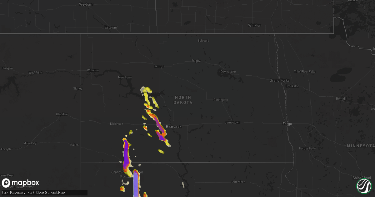
Hail Map in North Dakota on August 30, 2021
Get this storm
August 30 map
$229
one time, instant access
Download today. No call, no setup
Keep the $229
Bought the map and want the full workflow? Apply the entire $229 to a subscription within 7 days. None of it is wasted.
Every map, not just this one
This buys you this map. Subscription and you get every map we run, in the markets you choose from a few cities to whole states to nationwide. Plus real-time alerts the moment a storm fires.
Contact data
Name, contact info, occupancy, even credit band for addresses in the footprint. You go from where it hit to who to call.
Become the source they trust
Unlimited branding weather history reports on demand. You already have the documented answer ready for the property owner, and you are the one who showed up with it.
Property data and RoofTrace estimates
Pull up any address you have got, its value and the exact code rules for that jurisdiction, straight from One Click Code. Then RoofTrace estimates the squares, pitch, and roof value, priced the way you price.
Storm reports in North Dakota
North Dakota
| Date | Description |
|---|---|
| 08/30/20216:50 PM CDT | Report from august 30th storm. Not much wind... But large hail punched many holes through the metal roofs on pole barns. Five vehicles were substantially damaged. Hail |
| 08/30/20216:05 PM CDT | Report from august 30 storm. Crops were damaged and some windows were broken. Additional neighbors also had broken windows. |
| 08/30/20216:05 PM CDT | Report from august 30th storm. Time estimated from radar. Hailed for about one half hour. Crop was destroyed. |
| 08/30/20216:05 PM CDT | Report from august 30 storms. Tennis ball size hail combined with 60 mph wind gusts to cause extensive damage. All windows were broken out on north side of two homes. D |
| 08/30/20215:59 PM CDT | Photo relayed through social media... Including smashed windshield of car. Time estimated from radar but report included very large hail along highway 8 between hetting |
| 08/30/20215:57 PM CDT | Report from august 30 storm. Wind gust was measured while helping an individual in an overturned semi-truck. Winds were estimated to be even higher when the semi-truck |
| 08/30/20215:56 PM CDT | Social media report of overturned semi on highway 21 east of flasher at 5:56 pm cdt. Location estimated based on radar data at time of report. |
| 08/30/20215:55 PM CDT | Report from august 30 storms. Mainly dimes... A few quarters. |
| 08/30/20215:53 PM CDT | Time estimated from radar. Photos relayed through broadcast media. |
| 08/30/20215:50 PM CDT | Delayed report... Photo relayed through broadcast media. |
| 08/30/20215:34 PM CDT | Photo relayed through broadcast media. Time estimated from radar. |
| 08/30/20215:30 PM CDT | Report from august 30 storm. A few golf balls fell. Not much wind. |
| 08/30/20215:11 PM CDT | Hail ongoing for 15 minutes at the time of the call. No wind. 0.60 inches of rain. |
| 08/30/20214:55 PM CDT | Photo relayed through social media. |
| 08/30/20214:51 PM CDT | Report from mping: hen egg |
| 08/30/20214:50 PM CDT | Hail report from august 30 storm. Not much wind with the storm at this location. |
| 08/30/20214:18 PM CDT | Report from mping: quarter |
| 08/30/20214:05 PM CDT | Report from august 30 storm. Hail was between hen egg and tennis ball in size. Yard was white with hail... As it hailed for about one-half hour. 2.75 inches of rain als |
| 08/30/20214:00 PM CDT | Report from august 30 storm. Multiple vehicles were hail damaged. Canola crop nearby was severely damaged. |
| 08/30/20212:25 PM CDT | Report from august 30th storm. Various residents of the area were greatly damaged from baseball size hail. A couple of campers were damaged... Windows on homes were bro |
| 08/30/20212:24 PM CDT | Also estimated 50 mph winds. |
| 08/30/20212:11 PM CDT | A local report indicates 1.75 inch wind near 4 NE NEW SALEM |
| 08/30/20211:45 PM CDT | Report from august 30th. Hail damage a pickup truck. |
| 08/30/20211:40 PM CDT | Report from august 30 storm. |
| 08/30/20211:30 PM CDT | On highway 200 between beulah and hazen. Relayed through broadcast media. |
| 08/30/202112:14 PM CDT | Relayed through social media. Time estimated from radar. |
| 08/30/202111:00 AM CDT | Report from august 30. An unattached porch was tipped over. |
| 08/30/20217:58 AM CDT | At 1258 PM CDT, a severe thunderstorm was located 6 miles south of Hannover, or 24 miles northeast of Glen Ullin, moving southeast at 10 mph. HAZARD...Ping pong ball size hail and 60 mph wind gusts. SOURCE...Radar indicated. IMPACT...People and animals outdoors will be injured. Expect hail damage to roofs, siding, windows, and vehicles. Expect wind damage to roofs, siding, and trees. Locations impacted include... Center, Hannover, Sweet Briar Lake and Nelson Lake. |
| 08/30/20217:13 AM CDT | At 1212 PM CDT, a severe thunderstorm was located near Hannover, or 16 miles southeast of Beulah, moving southeast at 15 mph. HAZARD...Ping pong ball size hail and 60 mph wind gusts. SOURCE...Radar indicated. IMPACT...People and animals outdoors will be injured. Expect hail damage to roofs, siding, windows, and vehicles. Expect wind damage to roofs, siding, and trees. Locations impacted include... Hannover. |
| 08/30/20216:28 AM CDT | At 1127 AM CDT, a severe thunderstorm was located 9 miles west of Hannover, or 11 miles southeast of Beulah, and is nearly stationary. HAZARD...Golf ball size hail and 60 mph wind gusts. SOURCE...Radar indicated. IMPACT...People and animals outdoors will be injured. Expect hail damage to roofs, siding, windows, and vehicles. Expect wind damage to roofs, siding, and trees. Locations possibly impacted include... Hannover. |
| 08/30/20215:54 AM CDT | At 1054 AM CDT, a severe thunderstorm was located 9 miles south of Hazen, or 10 miles southeast of Beulah, moving southeast at 10 mph. HAZARD...60 mph wind gusts and half dollar size hail. SOURCE...Radar indicated. IMPACT...Hail damage to vehicles is expected. Expect wind damage to roofs, siding, and trees. This severe thunderstorm will remain over mainly rural areas of western Oliver County. |
| 08/30/20211:49 AM CDT | At 649 PM CDT/549 PM MDT/, severe thunderstorms were located along a line extending from 5 miles north of Solen to 7 miles west of Shields, moving southeast at 15 mph. HAZARD...60 mph wind gusts and quarter size hail. SOURCE...Radar indicated. IMPACT...Hail damage to vehicles is expected. Expect wind damage to roofs, siding, and trees. Severe thunderstorms will be near... Solen around 700 PM CDT.Other locations in the path of these severe thunderstorms includeCannon Ball, Fort Yates, Selfridge and Prairie Knights Resort. |
| 08/30/20211:02 AM CDT | At 601 PM CDT/501 PM MDT/, a severe thunderstorm was located 5 miles northeast of Flasher, or 25 miles southwest of Mandan, moving southeast at 15 mph. THIS IS A DESTRUCTIVE STORM FOR THE FLASHER AND BREIEN AREAS. HAZARD...Baseball size hail and 60 mph wind gusts. SOURCE...Radar indicated. IMPACT...People and animals outdoors will be severely injured. Expect shattered windows, extensive damage to roofs, siding, and vehicles. Locations impacted include... Solen and Breien. |
| 08/30/202112:54 AM CDT | At 553 PM CDT/453 PM MDT/, a severe thunderstorm was located 8 miles east of Heart Butte Dam, or 16 miles southeast of Glen Ullin, moving southeast at 15 mph. HAZARD...60 mph wind gusts and half dollar size hail. SOURCE...Radar indicated. IMPACT...Hail damage to vehicles is expected. Expect wind damage to roofs, siding, and trees. Locations impacted include... Carson. |
| 08/30/202112:53 AM CDT | At 553 PM MDT, a severe thunderstorm was located 4 miles northeast of Haynes, or 11 miles east of Hettinger, moving southeast at 20 mph. HAZARD...Tennis ball size hail and 60 mph wind gusts. SOURCE...Radar indicated. IMPACT...People and animals outdoors will be injured. Expect hail damage to roofs, siding, windows, and vehicles. Expect wind damage to roofs, siding, and trees. This severe thunderstorm will be near... White Butte around 610 PM MDT.Other locations in the path of this severe thunderstorm includeLemmon, Shadehill Reservoir and Shadehill. |
| 08/30/202112:43 AM CDT | At 543 PM CDT, severe thunderstorms were located along a line extending from 7 miles southeast of Roseglen to near Stanton, and are nearly stationary. HAZARD...Half dollar size hail. SOURCE...Radar indicated. IMPACT...Damage to vehicles is expected. These severe thunderstorms will remain over mainly rural areas of central McLean and northeastern Mercer Counties, including the following locations... Dakota Waters Recreation Area and Emmet. |
| 08/30/202112:30 AM CDT | At 529 PM MDT, a severe thunderstorm was located 8 miles north of Haynes, or 10 miles northeast of Hettinger, moving south at 15 mph. HAZARD...Tennis ball size hail and 60 mph wind gusts. SOURCE...Radar indicated. IMPACT...People and animals outdoors will be injured. Expect hail damage to roofs, siding, windows, and vehicles. Expect wind damage to roofs, siding, and trees. Locations impacted include... Haynes. |
| 08/30/202112:28 AM CDT | At 528 PM CDT, a severe thunderstorm was located 15 miles north of Glen Ullin, moving east at 25 mph. HAZARD...60 mph wind gusts and half dollar size hail. SOURCE...Radar indicated. IMPACT...Hail damage to vehicles is expected. Expect wind damage to roofs, siding, and trees. This severe thunderstorm will remain over mainly rural areas of southwestern Oliver and south central Mercer Counties. |
| 08/30/202112:00 AM CDT | At 500 PM CDT/400 PM MDT/, a severe thunderstorm was located 7 miles south of Fish Creek Dam, or 23 miles southwest of Mandan, moving southeast at 5 mph. HAZARD...Two inch hail and 60 mph wind gusts. SOURCE...Radar indicated. IMPACT...People and animals outdoors will be injured. Expect hail damage to roofs, siding, windows, and vehicles. Expect wind damage to roofs, siding, and trees. Locations impacted include... Flasher. |
| 08/29/202111:43 PM CDT | At 443 PM CDT/343 PM MDT/, a severe thunderstorm was located near Glen Ullin, moving southeast at 10 mph. HAZARD...Ping pong ball size hail and 60 mph wind gusts. SOURCE...Radar indicated. IMPACT...People and animals outdoors will be injured. Expect hail damage to roofs, siding, windows, and vehicles. Expect wind damage to roofs, siding, and trees. Locations impacted include... Almont. |
| 08/29/202111:29 PM CDT | At 429 PM MDT, a severe thunderstorm was located near Mott, moving southeast at 15 mph. THIS IS A DESTRUCTIVE STORM FOR SOUTHEASTERN HETTINGER AND NORTHEASTERN ADAMS COUNTIES. HAZARD...Baseball size hail and 60 mph wind gusts. SOURCE...Radar indicated. IMPACT...People and animals outdoors will be severely injured. Expect shattered windows, extensive damage to roofs, siding, and vehicles. This severe thunderstorm will remain over mainly rural areas of southeastern Hettinger and northeastern Adams Counties. |
| 08/29/202111:16 PM CDT | At 415 PM CDT, a severe thunderstorm was located 8 miles southeast of Fish Creek Dam, or 16 miles southwest of Mandan, moving southeast at 5 mph. HAZARD...Golf ball size hail and 60 mph wind gusts. SOURCE...Radar indicated. IMPACT...People and animals outdoors will be injured. Expect hail damage to roofs, siding, windows, and vehicles. Expect wind damage to roofs, siding, and trees. Locations impacted include... St. Anthony. |
| 08/29/202110:48 PM CDT | At 348 PM CDT, a severe thunderstorm was located 8 miles east of Roseglen, or 12 miles northwest of Garrison, moving east at 25 mph. HAZARD...60 mph wind gusts and half dollar size hail. SOURCE...Radar indicated. IMPACT...Hail damage to vehicles is expected. Expect wind damage to roofs, siding, and trees. Locations impacted include... Garrison and Max. |
| 08/29/202110:32 PM CDT | At 332 PM MDT, a severe thunderstorm was located 5 miles north of Regent, or 12 miles northwest of Mott, moving southeast at 10 mph. HAZARD...Ping pong ball size hail and 60 mph wind gusts. SOURCE...Radar indicated. IMPACT...People and animals outdoors will be injured. Expect hail damage to roofs, siding, windows, and vehicles. Expect wind damage to roofs, siding, and trees. This severe thunderstorm will be near... Regent around 350 PM MDT.Other locations in the path of this severe thunderstorm include Mott. |
| 08/29/202110:15 PM CDT | At 315 PM CDT, a severe thunderstorm was located over Fish Creek Dam, or 15 miles west of Mandan, moving southeast at 15 mph. HAZARD...Golf ball size hail and 60 mph wind gusts. SOURCE...Radar indicated. IMPACT...People and animals outdoors will be injured. Expect hail damage to roofs, siding, windows, and vehicles. Expect wind damage to roofs, siding, and trees. Locations impacted include... St. Anthony. |
| 08/29/20219:17 PM CDT | At 215 PM CDT, a severe thunderstorm was located near New Salem, or 19 miles west of Mandan, moving southeast at 10 mph. THIS IS A DESTRUCTIVE STORM FOR CENTRAL MORTON COUNTY INCLUDING SWEET BRIAR LAKE AND JUDSON. HAZARD...Baseball size hail and 60 mph wind gusts. SOURCE...Radar indicated. IMPACT...People and animals outdoors will be severely injured. Expect shattered windows, extensive damage to roofs, siding, and vehicles. Locations impacted include... Sweet Briar Lake, Judson, and Fish Creek Dam. |
| 08/29/20218:44 PM CDT | At 144 PM CDT, a severe thunderstorm was located over Hazen, or 7 miles east of Beulah, moving southeast at 10 mph. HAZARD...Ping pong ball size hail and 60 mph wind gusts. SOURCE...Radar indicated. IMPACT...People and animals outdoors will be injured. Expect hail damage to roofs, siding, windows, and vehicles. Expect wind damage to roofs, siding, and trees. This severe thunderstorm will remain over mainly rural areas of northwestern Oliver and central Mercer Counties. |
| 08/29/20218:42 PM CDT | At 142 PM CDT, a severe thunderstorm was located 7 miles northeast of New Salem, or 20 miles west of Mandan, moving southeast at 10 mph. HAZARD...Two inch hail. SOURCE...Radar indicated. IMPACT...People and animals outdoors will be injured. Expect damage to roofs, siding, windows, and vehicles. This severe thunderstorm will remain over mainly rural areas of north central Morton and south central Oliver Counties, including the following locations... Sweet Briar Lake, Judson and Crown Butte Lake. |
| 08/29/20218:02 PM CDT | At 101 PM CDT, a severe thunderstorm was located near Hazen, or 5 miles northeast of Beulah, moving southeast at 10 mph. HAZARD...Ping pong ball size hail and 60 mph wind gusts. SOURCE...Radar indicated. IMPACT...People and animals outdoors will be injured. Expect hail damage to roofs, siding, windows, and vehicles. Expect wind damage to roofs, siding, and trees. This severe thunderstorm will be near... Hazen around 115 PM CDT. |
| 08/29/20217:15 PM CDT | Hail ranging in size from marble to baseball fell from 600 to 615 pm mdt. Report relayed by emergency management. |
| 08/29/20217:15 PM CDT | Report from august 30th storm. Wind driven hail near the hiddenwood hunt teepee site shredded a very nice looking field of eight foot high corn down to knee high. |
All States Impacted by Hail Map on August 30, 2021
Cities Impacted by Hail Map on August 30, 2021
- Randolph, NE
- Carroll, NE
- Hoskins, NE
- Danville, IN
- Coatesville, IN
- Parkston, SD
- Syracuse, NE
- Avoca, NE
- Weeping Water, NE
- Alvo, NE
- Elmwood, NE
- Dunbar, NE
- Unadilla, NE
- Otoe, NE
- Hiawatha, KS
- Hartington, NE
- Niobrara, NE
- Lyerly, GA
- Rome, GA
- Solen, ND
- Center, ND
- New Salem, ND
- Beulah, ND
- Saint Anthony, ND
- Almont, ND
- Hazen, ND
- Flasher, ND
- Mandan, ND
- Meadow, SD
- Geddes, SD
- Platte, SD
- Waterloo, NE
- Yutan, NE
- Newman Grove, NE
- Saint Edward, NE
- Albion, NE
- Ethan, SD
- Mission, SD
- Nehawka, NE
- Plattsmouth, NE
- Louisville, NE
- Stanton, ND
- Lemmon, SD
- Hettinger, ND
- Corsica, SD
- Mount Vernon, SD
- Stickney, SD
- Mitchell, SD
- Canton, SD
- Inwood, IA
- Volin, SD
- Hooper, NE
- Fremont, NE
- Ames, NE
- North Bend, NE
- Wagner, SD
- Avon, SD
- Dante, SD
- Deloit, IA
- Cushing, IA
- Kiron, IA
- Manning, IA
- Holstein, IA
- Templeton, IA
- Schleswig, IA
- Manilla, IA
- Denison, IA
- Odebolt, IA
- Vail, IA
- Battle Creek, IA
- Westside, IA
- Arthur, IA
- Arcadia, IA
- Ida Grove, IA
- Omaha, NE
- Murray, NE
- Cedar Creek, NE
- Springfield, NE
- Elkhorn, NE
- Ashland, NE
- Gretna, NE
- Witten, SD
- Ideal, SD
- Windsor, VA
- Suffolk, VA
- Bison, SD
- Waverly, NE
- Greenwood, NE
- Verdigre, NE
- Wood Lake, NE
- Gaylesville, AL
- Eureka, MO
- Wildwood, MO
- Dupree, SD
- Creston, NE
- Columbus, NE
- Humphrey, NE
- Elgin, ND
- Carson, ND
- Stephan, SD
- Highmore, SD
- Lower Brule, SD
- Kennebec, SD
- Fairview, SD
- Faith, SD
- Harrison, SD
- Waterloo, IL
- Glen Ullin, ND
- Garrison, ND
- Vivian, SD
- Mott, ND
- Shelby, NE
- Osceola, NE
- Oakland, IA
- Wynot, NE
- Bloomfield, NE
- Crofton, NE
- Mount Solon, VA
- Osmond, NE
- Pierce, NE
- Winside, NE
- Petersburg, VA
- Hawarden, IA
- Rawlings, VA
- Fulton, SD
- Bronson, IA
- Ute, IA
- Mapleton, IA
- Hornick, IA
- Arion, IA
- Lawton, IA
- Moville, IA
- Rodney, IA
- Dow City, IA
- Smithland, IA
- Castana, IA
- Charter Oak, IA
- Dunlap, IA
- Sioux City, IA
- Anthon, IA
- Sergeant Bluff, IA
- Climbing Hill, IA
- Oto, IA
- Brodnax, VA
- La Crosse, VA
- Lynch, NE
- Unionville, MO
- Cayuga, IN
- Kingman, IN
- Hillsdale, IN
- Menno, SD
- Olivet, SD
- Freeman, SD
- Lenora, KS
- Creighton, NE
- Winnetoon, NE
- Brunswick, NE
- Hebron, ND
- Valentine, NE
- Ireton, IA
- Hancock, IA
- Griswold, IA
- Winner, SD
- Springfield, SD
- Roseglen, ND
- White River, SD
- Emery, SD
- Neola, IA
- Underwood, IA
- Stuart, NE
- Chamberlain, SD
- Pukwana, SD
- Oakdale, NE
- Dodge, NE
- Howells, NE
- Pilger, NE
- Wisner, NE
- Stanton, NE
- Wakonda, SD
- Artesian, SD
- Wausa, NE
- Norfolk, NE
- West Point, NE
- Wayne, NE
- Scribner, NE
- Plainview, NE
- Woonsocket, SD
- Ewing, NE
- Draper, SD
- Regent, ND
- Eagle Butte, SD
- Tyndall, SD
- Plankinton, SD
- Dimock, SD
- White Lake, SD
- Madison, NE
- Washburn, ND
- Sandy Hook, VA
- Goochland, VA
- Fordyce, NE
- Coleridge, NE
- Beresford, SD
- Alcester, SD
- Centerville, SD
- Vermillion, SD
- Worthing, SD
- Kimball, SD
- Clearwater, NE
- Neligh, NE
- Crookston, NE
- Akron, IA
- Irene, SD
- Elk Point, SD
- Roach, MO
- Clarkson, NE
- Nebraska City, NE
- Eagle, NE
- Lincoln, NE
- Murdock, NE
- Bonesteel, SD
- Tripp, SD
- Presho, SD
- Wood, SD
- Gregory, SD
- Dallas, SD
- Papillion, NE
- Memphis, NE
- Le Mars, IA
- Brunsville, IA
- Hamill, SD
- Alexandria, SD
- Emporia, VA
- Ryder, ND
- Blair, NE
- Shields, ND
- Herman, NE
- Fort Calhoun, NE
- Modale, IA
- Missouri Valley, IA
- Mclean, NE
- Crawfordsville, IN
- Burbank, SD
- Bridgewater, SD
- Calhoun, GA
- Adairsville, GA
- Saint Francis, KS
- Lodgepole, SD
- Bloomingdale, IN
- Montezuma, IN
- Rockville, IN
- Pacific, MO
- Saint Charles, SD
- Chesterfield, VA
- Center, NE
- Chestertown, MD
- Ashmore, IL
- Armour, SD
- Percival, IA
- Union, NE
- Gray, IA
- Audubon, IA
- Correctionville, IA
- Aspinwall, IA
- Carroll, IA
- Bancroft, NE
- Pender, NE
- Brayton, IA
- Anita, IA
- Exira, IA
- Robinson, KS
- Falls City, NE
- Rock Valley, IA
- Hudson, SD
- Sedona, AZ
- Reliance, SD
- Palmyra, NE
- Dutton, VA
- Gloucester, VA
- Murdo, SD
- Saint Helena, NE
- Georgetown, KY
- Wessington, SD
- Wessington Springs, SD
- Orchard, NE
- Tilden, NE
- Elgin, NE
- Thurman, IA
- Richardton, ND
- Malmo, NE
- Colon, NE
- Cedar Bluffs, NE
- Mead, NE
- Twentynine Palms, CA
- Alpena, SD
- Ladoga, IN
- Roachdale, IN
- Dawson, NE
- Verdon, NE
- Colome, SD
- Scotland, SD
- Hinton, IA
- Jefferson, SD
- Danbury, IA
- Defiance, IA
- North Sioux City, SD
- Westfield, IA
- Okaton, SD
- Parmelee, SD
- Gann Valley, SD
- Rising City, NE
- Minden, IA
- Council Bluffs, IA
- McClelland, IA
- Capron, VA
- Boykins, VA
- Saint Francis, SD
- Hamburg, IA
- Morse Bluff, NE
- Valley, NE
- Ceresco, NE
- Ithaca, NE
- South Bend, NE
- Wolsey, SD
- Belvidere, SD
- Lewis, IA
- Kadoka, SD
- Long Valley, SD
- Maurice, IA
- Novinger, MO
- Worthington, MO
- Livonia, MO
- Yale, VA
- Paris, IL
- Chrisman, IL
- Dana, IN
- Newsoms, VA
- Courtland, VA
- Craig, NE
- Tekamah, NE
- Snyder, NE
- Oneill, NE
- Meadow Grove, NE
- Beemer, NE
- Platte Center, NE
- Pacific Junction, IA
- Warner Springs, CA
- Atkinson, NE
- Sadieville, KY
- Marion, SD
- Moseley, VA
- Amelia Court House, VA
- Midlothian, VA
- Powhatan, VA
- Honey Creek, IA
- Crescent, IA
- Henderson, IA
- David City, NE
- Brainard, NE
- Nanjemoy, MD
- Letcher, SD
- Lennox, SD
- Danville, VA
- Ringgold, VA
- Charleston, IL
- Gettysburg, SD
- Walnut, IA
- Valmeyer, IL
- Richmond, VA
- Doon, IA
- Fulton, MO
- Lefor, ND
- Hill City, SD
- Rapid City, SD
- Milesville, SD
- Howes, SD
- Wall, SD
- Philip, SD
- Wasta, SD
- White Owl, SD
- Keystone, SD
- Custer, SD
- Fairburn, SD
- Buffalo Gap, SD
- Cherry Creek, SD
- Manley, NE
- Winslow, NE
- Arlington, NE
- Nickerson, NE
- Midland, SD
- Rosebud, SD
- Fort Pierre, SD
- Sparks, NE
- Springview, NE
- Norris, SD
- Des Moines, IA
- Prole, IA
- Van Meter, IA
- Johnston, IA
- Liberty Center, IA
- Urbandale, IA
- Luther, IA
- Indianola, IA
- Woodburn, IA
- Madrid, IA
- Osceola, IA
- Waukee, IA
- Granger, IA
- Winterset, IA
- Clive, IA
- Ankeny, IA
- Chariton, IA
- Martensdale, IA
- Saint Marys, IA
- Ackworth, IA
- Dallas Center, IA
- Carlisle, IA
- Norwalk, IA
- Boone, IA
- Saint Charles, IA
- New Virginia, IA
- Kelley, IA
- Windsor Heights, IA
- Cumming, IA
- Booneville, IA
- Woodward, IA
- Lacona, IA
- Williamson, IA
- Grimes, IA
- Milo, IA
- Adel, IA
- Bevington, IA
- Patterson, IA
- Polk City, IA
- Lucas, IA
- Truro, IA
- West Des Moines, IA


