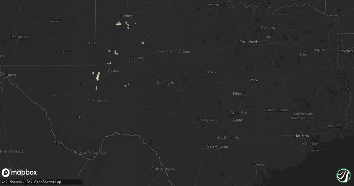
Hail Map in Texas on August 28, 2022
Get this storm
August 28 map
$229
one time, instant access
Download today. No call, no setup
Keep the $229
Bought the map and want the full workflow? Apply the entire $229 to a subscription within 7 days. None of it is wasted.
Every map, not just this one
This buys you this map. Subscription and you get every map we run, in the markets you choose from a few cities to whole states to nationwide. Plus real-time alerts the moment a storm fires.
Contact data
Name, contact info, occupancy, even credit band for addresses in the footprint. You go from where it hit to who to call.
Become the source they trust
Unlimited branding weather history reports on demand. You already have the documented answer ready for the property owner, and you are the one who showed up with it.
Property data and RoofTrace estimates
Pull up any address you have got, its value and the exact code rules for that jurisdiction, straight from One Click Code. Then RoofTrace estimates the squares, pitch, and roof value, priced the way you price.
Storm reports in Texas
Texas
| Date | Description |
|---|---|
| 08/28/20225:42 PM CDT | West texas mesonet report |
| 08/28/20225:37 PM CDT | Delayed report. Broadcast media relayed photos of multiple large trees downed in central lubbock resulting in damage to a home and several fences. Time estimated from r |
| 08/28/20225:37 PM CDT | Delayed report. Multiple power poles snapped along ave u near 45th st. Time estimated from radar. |
| 08/28/20225:02 PM CDT | Mesonet station 123 1nw castolon... Bbnp big bend np/brewster. |
| 08/28/20224:19 AM CDT | At 918 PM CDT, a severe thunderstorm was located 8 miles north of Monahans, moving south at 10 mph. HAZARD...60 mph wind gusts and half dollar size hail. SOURCE...Radar indicated. IMPACT...Hail damage to vehicles is expected. Expect wind damage to roofs, siding, and trees. Locations impacted include... Monahans, Wink, Thorntonville, Pyote, Wickett, Roy Hurd Memorial Airport, Winkler County Airport and Monahans Sandhills State Park.This includes Interstate 20 between mile markers 67 and 87. |
| 08/28/20221:50 AM CDT | At 649 PM CDT, severe thunderstorms were located along a line extending from near Lenorah to 7 miles north of Midland to 12 miles northwest of Midland International Air and Space Port, moving southeast at 30 mph. HAZARD...60 mph wind gusts and quarter size hail. SOURCE...Radar indicated. IMPACT...Hail damage to vehicles is expected. Expect wind damage to roofs, siding, and trees. Locations impacted include... Midland, Big Spring, Greenwood, Stanton, Forsan, Lomax, Lenorah, Midland International Air and Space Port, Tarzan, Cotton Flat, Warfield, Midland Airpark, Skywest Airport, Big Spring Country Club, Courtney, Big Spring McMahon-Wrinkle Airpark, Elbow, Stanton Municipal Aiport and Spraberry.This includes Interstate 20 between mile markers 126 and 175. |
| 08/28/202212:06 AM CDT | At 506 PM CDT, a severe thunderstorm was located 4 miles northwest of Brice, or 12 miles south of Clarendon, moving northeast at 10 mph. HAZARD...60 mph wind gusts and quarter size hail. SOURCE...Radar indicated. IMPACT...Minor damage to roofs, siding, and trees is possible. Hail damage to vehicles is expected. Locations impacted include... Clarendon, Howardwick, Hedley, Lelia Lake and Greenbelt Lake. |
| 08/27/202211:31 PM CDT | West texas mesonet station in coyanosa. |
| 08/27/20228:31 PM CDT | Multiple buildings with tin roof damage south of bi-20 near dixie blvd. Damage estimates winds near 85 mph. |
| 08/27/20228:30 PM CDT | 8 power poles snapped at the base near the 1400 block of e 2nd st in odessa along bi-20. Wind damage estimates wind speeds of 95 mph. |
All States Impacted by Hail Map on August 28, 2022
Cities Impacted by Hail Map on August 28, 2022
- Andover, MN
- Minneapolis, MN
- Howard Lake, MN
- Bigfork, MN
- Ypsilanti, ND
- Marion, ND
- Downs, KS
- Osborne, KS
- Kimball, MN
- Eden Valley, MN
- Paynesville, MN
- Richmond, MN
- Watkins, MN
- South Haven, MN
- Cold Spring, MN
- Hinckley, MN
- Tahoka, TX
- White Deer, TX
- Panhandle, TX
- Fingal, ND
- Kathryn, ND
- Dexter, IA
- Stuart, IA
- Casey, IA
- Exira, IA
- Menlo, IA
- Adair, IA
- Anita, IA
- La Pointe, WI
- Tennessee Ridge, TN
- Stewart, TN
- Loudon, TN
- Philadelphia, TN
- Ludlow, IL
- Paxton, IL
- Thomasboro, IL
- Rantoul, IL
- Urbana, IL
- Loda, IL
- Gifford, IL
- Rankin, IL
- Saint Joseph, IL
- Pulaski, WI
- Norman, OK
- Brownfield, TX
- Meadow, TX
- Clarendon, TX
- Sterling, IL
- Bensenville, IL
- Pine City, MN
- Brook Park, MN
- Medford, WI
- Webster, WI
- Columbia, MO
- Merrill, WI
- Weyerhaeuser, WI
- Bruce, WI
- Exeland, WI
- Argyle, MO
- Meta, MO
- Suamico, WI
- Midkiff, TX
- Cook, MN
- Mountain, WI
- Mcintosh, MN
- Fosston, MN
- Buffalo, ND
- Andrews, TX
- Clara City, MN
- Monahans, TX
- Nome, ND
- Litchville, ND
- Van Buren, AR
- Fort Smith, AR
- Ladysmith, WI
- Jonesville, SC
- Sharon, SC
- Two Harbors, MN
- Grand Rapids, MN
- Bovey, MN
- Cohasset, MN
- Cerro Gordo, IL
- Milmine, IL
- Hammond, IL
- Gilman, WI
- Sheldon, WI
- Springerton, IL
- McLeansboro, IL
- Valley City, ND
- Quitaque, TX
- Hancock, IA
- Oakland, IA
- Minden, IA
- Argenta, IL
- Harlan, IA
- Lebanon, MO
- Elkhorn, NE
- Brazil, IN
- Cory, IN
- Centerpoint, IN
- Big Rock, IL
- Leland, IL
- Sandwich, IL
- Somonauk, IL
- Hinckley, IL
- Elburn, IL
- Annandale, MN
- Winger, MN
- Waterman, IL
- Shabbona, IL
- Dekalb, IL
- Stigler, OK
- Alborn, MN
- McClelland, IA
- Marshall, IL
- Dennison, IL
- Ten Mile, TN
- Makinen, MN
- Withee, WI
- Yale, IL
- Willow Hill, IL
- Littlefork, MN
- Big Falls, MN
- Panama, IA
- Westphalia, IA
- Portsmouth, IA
- Earling, IA
- Oakland, IL
- Crivitz, WI
- Pound, WI
- White Lake, WI
- Chamois, MO
- Bland, MO
- Linn, MO
- Wyoming, MN
- Polo, IL
- Chadwick, IL
- Lyndon, IL
- Morrison, IL
- Milledgeville, IL
- Sweetwater, TN
- Westboro, WI
- Ogema, WI
- Mora, MN
- Grasston, MN
- Goldsmith, TX
- Park Ridge, IL
- Niles, IL
- Morton Grove, IL
- Chicago, IL
- Martinsville, IL
- Hanna, OK
- Federal Dam, MN
- Catawba, WI
- Sandstone, MN
- Raymond, MN
- Mikana, WI
- Rice Lake, WI
- Anderson, SC
- Oklahoma City, OK
- Cotton, MN
- Gleason, WI
- Lublin, WI
- Athens, WI
- Rib Lake, WI
- Deerbrook, WI
- Tomahawk, WI
- Antigo, WI
- Irma, WI
- Thorp, WI
- Maple Park, IL
- Cortland, IL
- Earlville, IL
- Lee, IL
- Paw Paw, IL
- Hawkins, WI
- Glen Flora, WI
- Conrath, WI
- Kennan, WI
- Tony, WI
- Holcombe, WI
- Amorita, OK
- Burlington, OK
- Bison, KS
- Harmon, IL
- Cameron, WI
- Longville, MN
- Post, TX
- Fort Ransom, ND
- Remer, MN
- Walker, MN
- Kelliher, MN
- Blackduck, MN
- Redby, MN
- Watertown, MN
- Mayer, MN
- Wilson, TX
- Grantsburg, WI
- Wright, MN
- Floodwood, MN
- Waverly, MN
- Buffalo, MN
- Bokoshe, OK
- Spiro, OK
- Birchwood, WI
- Waterloo, NE
- Amarillo, TX
- Omaha, NE
- Wink, TX
- Warba, MN
- Deer River, MN
- Akeley, MN
- Hackensack, MN
- Nevis, MN
- Newton, IL
- Danbury, WI
- Wabeno, WI
- Fort Calhoun, NE
- Lisbon, ND
- Enderlin, ND
- Ponemah, MN
- Lakeview, TX
- Hines, MN
- Shell Lake, WI
- Sarona, WI
- Barronett, WI
- Glencoe, MN
- Brownton, MN
- New Germany, MN
- Malden, IL
- Olney, IL
- Woodbine, IA
- Plymouth, IN
- Walkerton, IN
- Bena, MN
- Kennard, NE
- Washington, NE
- Blair, NE
- Arlington, NE
- Bennington, NE
- Valley, NE
- Poland, IN
- Coal City, IN
- Patricksburg, IN
- Bowling Green, IN
- Arlington, IL
- La Moille, IL
- Coyanosa, TX
- Griswold, IA
- Kermit, TX
- Malta, IL
- Clare, IL
- Sycamore, IL
- Rochelle, IL
- Steward, IL
- Golden Gate, IL
- Parkersburg, IL
- West Salem, IL
- Mount Erie, IL
- Comstock, WI
- Cumberland, WI
- Long Lake, MN
- Wayzata, MN
- Ashmore, IL
- Charleston, IL
- Brocton, IL
- Gully, MN
- Gail, TX
- Red Oak, OK
- Green Bay, WI
- Henriette, MN
- Clearwater, MN
- Maple Lake, MN
- Monticello, MN
- Hopkins, MN
- Gonvick, MN
- Chetek, WI
- Little Suamico, WI
- Eufaula, OK
- Checotah, OK
- Clearbrook, MN
- Prinsburg, MN
- Maynard, MN
- Blomkest, MN
- Lake Lillian, MN
- Northome, MN


