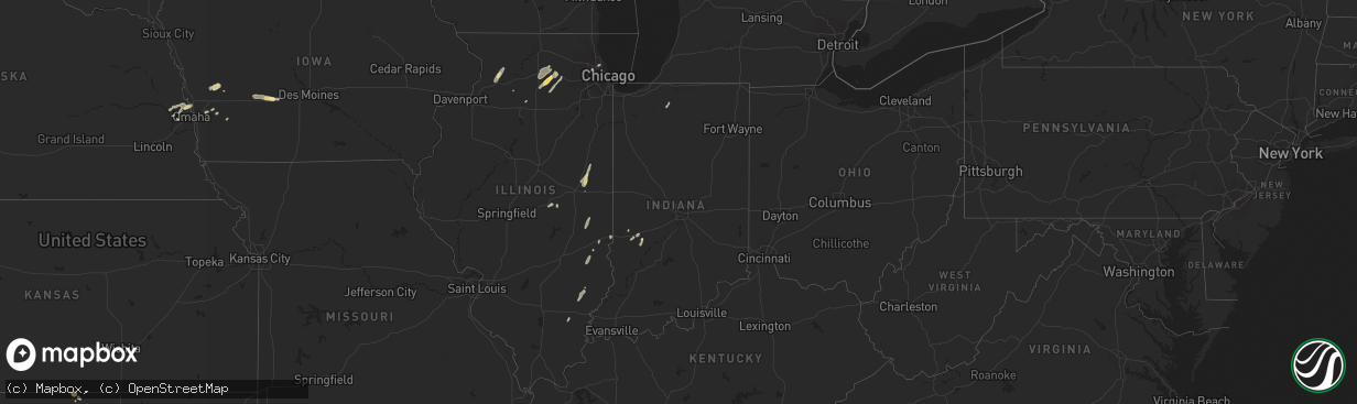
Hail Map in Indiana on August 28, 2022
The weather event in Indiana on August 28, 2022 includes Hail, Wind, and Tornado maps. 14 states and 286 cities were impacted and suffered possible damage. The total estimated number of properties impacted is 0.
Want more than just the map?
Turn this storm into a full workflow.
- Owner + property data so you know who to knock
- OnDemand branded weather history reports to win the "did we even have hail?" argument
- RoofTrace estimate so reps stop guessing numbers at the door
Bought this map? Upgrade within 7 days and we'll credit the $230. (10-15 min setup call)
Hail
Wind
Tornado
0
Estimated number of impacted properties by a 1.00" hail or larger0
Estimated number of impacted properties by a 1.75" hail or larger0
Estimated number of impacted properties by a 2.50" hail or largerStorm reports in Indiana
Indiana
| Date | Description |
|---|---|
| 08/28/20221:48 PM CDT | Report from mping: half dollar |
| 08/28/20226:24 AM CDT | At 1123 PM EDT, a severe thunderstorm was located over Lakeville, or 7 miles south of Gulivoire Park, moving northeast at 45 mph. HAZARD...60 mph wind gusts. SOURCE...Radar indicated. IMPACT...Expect damage to roofs, siding, and trees. Locations impacted include... South Bend, Elkhart, Mishawaka, Goshen, Dunlap, Gulivoire Park, Granger, Osceola, North Liberty, Wakarusa, Lakeville, Woodland, Jimtown and Wyatt.This includes Interstate 80 in Indiana between mile markers 84 and89. |
| 08/28/20226:07 AM CDT | At 1107 PM EDT/1007 PM CDT/, a severe thunderstorm was located 7 miles north of Winamac, moving northeast at 45 mph. HAZARD...60 mph wind gusts. SOURCE...Radar indicated. IMPACT...Expect damage to roofs, siding, and trees. Locations impacted include... Plymouth, Bremen, Knox, Winamac, Bourbon, Argos, Culver, Walnut, Tippecanoe, Oak Grove, Ripley, La Paz, Monterey, Leiters Ford, Beardstown, Ober, Tyner, Hibbard, Winona and Delong. |
| 08/27/202210:30 PM CDT | Several trees and powerlines downed around the county... Including primrose rd in south bend... And near the 76th mm of sr-23. |
| 08/27/202210:25 PM CDT | Several trees down near the intersection of oak and riley roads. |
All States Impacted by Hail Map on August 28, 2022
Cities Impacted by Hail Map on August 28, 2022
- Andover, MN
- Minneapolis, MN
- Howard Lake, MN
- Bigfork, MN
- Ypsilanti, ND
- Marion, ND
- Downs, KS
- Osborne, KS
- Kimball, MN
- Eden Valley, MN
- Paynesville, MN
- Richmond, MN
- Watkins, MN
- South Haven, MN
- Cold Spring, MN
- Hinckley, MN
- Tahoka, TX
- White Deer, TX
- Panhandle, TX
- Fingal, ND
- Kathryn, ND
- Dexter, IA
- Stuart, IA
- Casey, IA
- Exira, IA
- Menlo, IA
- Adair, IA
- Anita, IA
- La Pointe, WI
- Tennessee Ridge, TN
- Stewart, TN
- Loudon, TN
- Philadelphia, TN
- Ludlow, IL
- Paxton, IL
- Thomasboro, IL
- Rantoul, IL
- Urbana, IL
- Loda, IL
- Gifford, IL
- Rankin, IL
- Saint Joseph, IL
- Pulaski, WI
- Norman, OK
- Brownfield, TX
- Meadow, TX
- Clarendon, TX
- Sterling, IL
- Bensenville, IL
- Pine City, MN
- Brook Park, MN
- Medford, WI
- Webster, WI
- Columbia, MO
- Merrill, WI
- Weyerhaeuser, WI
- Bruce, WI
- Exeland, WI
- Argyle, MO
- Meta, MO
- Suamico, WI
- Midkiff, TX
- Cook, MN
- Mountain, WI
- Mcintosh, MN
- Fosston, MN
- Buffalo, ND
- Andrews, TX
- Clara City, MN
- Monahans, TX
- Nome, ND
- Litchville, ND
- Van Buren, AR
- Fort Smith, AR
- Ladysmith, WI
- Jonesville, SC
- Sharon, SC
- Two Harbors, MN
- Grand Rapids, MN
- Bovey, MN
- Cohasset, MN
- Cerro Gordo, IL
- Milmine, IL
- Hammond, IL
- Gilman, WI
- Sheldon, WI
- Springerton, IL
- McLeansboro, IL
- Valley City, ND
- Quitaque, TX
- Hancock, IA
- Oakland, IA
- Minden, IA
- Argenta, IL
- Harlan, IA
- Lebanon, MO
- Elkhorn, NE
- Brazil, IN
- Cory, IN
- Centerpoint, IN
- Big Rock, IL
- Leland, IL
- Sandwich, IL
- Somonauk, IL
- Hinckley, IL
- Elburn, IL
- Annandale, MN
- Winger, MN
- Waterman, IL
- Shabbona, IL
- Dekalb, IL
- Stigler, OK
- Alborn, MN
- McClelland, IA
- Marshall, IL
- Dennison, IL
- Ten Mile, TN
- Makinen, MN
- Withee, WI
- Yale, IL
- Willow Hill, IL
- Littlefork, MN
- Big Falls, MN
- Panama, IA
- Westphalia, IA
- Portsmouth, IA
- Earling, IA
- Oakland, IL
- Crivitz, WI
- Pound, WI
- White Lake, WI
- Chamois, MO
- Bland, MO
- Linn, MO
- Wyoming, MN
- Polo, IL
- Chadwick, IL
- Lyndon, IL
- Morrison, IL
- Milledgeville, IL
- Sweetwater, TN
- Westboro, WI
- Ogema, WI
- Mora, MN
- Grasston, MN
- Goldsmith, TX
- Park Ridge, IL
- Niles, IL
- Morton Grove, IL
- Chicago, IL
- Martinsville, IL
- Hanna, OK
- Federal Dam, MN
- Catawba, WI
- Sandstone, MN
- Raymond, MN
- Mikana, WI
- Rice Lake, WI
- Anderson, SC
- Oklahoma City, OK
- Cotton, MN
- Gleason, WI
- Lublin, WI
- Athens, WI
- Rib Lake, WI
- Deerbrook, WI
- Tomahawk, WI
- Antigo, WI
- Irma, WI
- Thorp, WI
- Maple Park, IL
- Cortland, IL
- Earlville, IL
- Lee, IL
- Paw Paw, IL
- Hawkins, WI
- Glen Flora, WI
- Conrath, WI
- Kennan, WI
- Tony, WI
- Holcombe, WI
- Amorita, OK
- Burlington, OK
- Bison, KS
- Harmon, IL
- Cameron, WI
- Longville, MN
- Post, TX
- Fort Ransom, ND
- Remer, MN
- Walker, MN
- Kelliher, MN
- Blackduck, MN
- Redby, MN
- Watertown, MN
- Mayer, MN
- Wilson, TX
- Grantsburg, WI
- Wright, MN
- Floodwood, MN
- Waverly, MN
- Buffalo, MN
- Bokoshe, OK
- Spiro, OK
- Birchwood, WI
- Waterloo, NE
- Amarillo, TX
- Omaha, NE
- Wink, TX
- Warba, MN
- Deer River, MN
- Akeley, MN
- Hackensack, MN
- Nevis, MN
- Newton, IL
- Danbury, WI
- Wabeno, WI
- Fort Calhoun, NE
- Lisbon, ND
- Enderlin, ND
- Ponemah, MN
- Lakeview, TX
- Hines, MN
- Shell Lake, WI
- Sarona, WI
- Barronett, WI
- Glencoe, MN
- Brownton, MN
- New Germany, MN
- Malden, IL
- Olney, IL
- Woodbine, IA
- Plymouth, IN
- Walkerton, IN
- Bena, MN
- Kennard, NE
- Washington, NE
- Blair, NE
- Arlington, NE
- Bennington, NE
- Valley, NE
- Poland, IN
- Coal City, IN
- Patricksburg, IN
- Bowling Green, IN
- Arlington, IL
- La Moille, IL
- Coyanosa, TX
- Griswold, IA
- Kermit, TX
- Malta, IL
- Clare, IL
- Sycamore, IL
- Rochelle, IL
- Steward, IL
- Golden Gate, IL
- Parkersburg, IL
- West Salem, IL
- Mount Erie, IL
- Comstock, WI
- Cumberland, WI
- Long Lake, MN
- Wayzata, MN
- Ashmore, IL
- Charleston, IL
- Brocton, IL
- Gully, MN
- Gail, TX
- Red Oak, OK
- Green Bay, WI
- Henriette, MN
- Clearwater, MN
- Maple Lake, MN
- Monticello, MN
- Hopkins, MN
- Gonvick, MN
- Chetek, WI
- Little Suamico, WI
- Eufaula, OK
- Checotah, OK
- Clearbrook, MN
- Prinsburg, MN
- Maynard, MN
- Blomkest, MN
- Lake Lillian, MN
- Northome, MN


