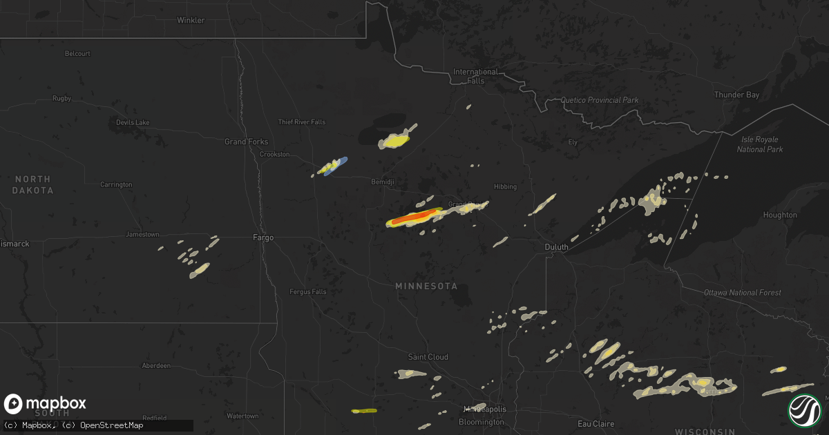
Hail Map on August 28, 2022
Get this storm
August 28 map
$229
one time, instant access
Download today. No call, no setup
Keep the $229
Bought the map and want the full workflow? Apply the entire $229 to a subscription within 7 days. None of it is wasted.
Every map, not just this one
This buys you this map. Subscription and you get every map we run, in the markets you choose from a few cities to whole states to nationwide. Plus real-time alerts the moment a storm fires.
Contact data
Name, contact info, occupancy, even credit band for addresses in the footprint. You go from where it hit to who to call.
Become the source they trust
Unlimited branding weather history reports on demand. You already have the documented answer ready for the property owner, and you are the one who showed up with it.
Property data and RoofTrace estimates
Pull up any address you have got, its value and the exact code rules for that jurisdiction, straight from One Click Code. Then RoofTrace estimates the squares, pitch, and roof value, priced the way you price.
States Impacted by Hail Map on August 28, 2022
Storm reports
South Carolina
| Date | Description |
|---|---|
| 08/28/20224:28 PM CDT | County reports two trees blown down. |
| 08/28/202212:54 AM CDT | At 554 PM EDT, a severe thunderstorm was located 10 miles northeast of Union, or near Lockhart, moving west at 10 mph. HAZARD...60 mph wind gusts and quarter size hail. SOURCE...Radar indicated. IMPACT...Minor hail damage to vehicles is expected. Expect wind damage to trees and power lines. Locations impacted include... Union, Monarch Mill, Buffalo, Jonesville, Lockhart, Saratt, Adamsburg and Bullock Creek. |
| 08/28/202212:23 AM CDT | At 522 PM EDT, a severe thunderstorm was located 8 miles south of York, or near Mcconnells, moving west at 5 mph. HAZARD...60 mph wind gusts and quarter size hail. SOURCE...Radar indicated. IMPACT...Minor hail damage to vehicles is expected. Expect wind damage to trees and power lines. Locations impacted include... Lockhart, Sharon, Hickory Grove, Mcconnells, Lowrys and Bullock Creek. |
Iowa
| Date | Description |
|---|---|
| 08/28/20226:39 AM CDT | Trained spotter called in and reported quarter sized hail. No strong winds associated with it. |
Tennessee
| Date | Description |
|---|---|
| 08/28/20225:19 PM CDT | A few trees down. |
| 08/28/20223:24 PM CDT | Several trees down. |
| 08/28/20221:00 AM CDT | At 559 PM EDT, a severe thunderstorm was located 7 miles east of Knoxville, moving northwest at 5 mph. HAZARD...60 mph wind gusts. SOURCE...Radar indicated. IMPACT...Expect damage to roofs, siding, and trees. Locations impacted include... Knoxville, House Mountain State Park, Maloneyville, Lake Forest, Mascot and Kimberlin Heights.This includes the following highways... Interstate 40 in Tennessee between mile markers 387 and 401. Interstate 75 in Tennessee between mile markers 108 and 110. |
| 08/27/202211:02 PM CDT | At 401 PM EDT, a severe thunderstorm was located 8 miles west of Sweetwater, moving north at 10 mph. HAZARD...60 mph wind gusts. SOURCE...Radar indicated. IMPACT...Expect damage to roofs, siding, and trees. Locations impacted include... Kingston, Rockwood, Fairview, Midtown, Harriman, Eagle Furnace and Ten Mile.This includes Interstate 40 in Tennessee between mile markers 348 and352. |
| 08/27/202210:43 PM CDT | At 343 PM EDT, a severe thunderstorm was located near Sweetwater, and is nearly stationary. HAZARD...60 mph wind gusts. SOURCE...Radar indicated. IMPACT...Expect damage to roofs, siding, and trees. Locations impacted include... Sweetwater, Loudon, Philadelphia and Paint Rock. This includes Interstate 75 in Tennessee between mile markers 61 and74. |
Arkansas
| Date | Description |
|---|---|
| 08/28/202212:37 AM CDT | At 537 PM CDT, a severe thunderstorm was located 4 miles northeast of Barling, moving northeast at 15 mph. HAZARD...60 mph wind gusts and quarter size hail. SOURCE...Radar indicated. IMPACT...Hail damage to vehicles is expected. Expect wind damage to roofs, siding, and trees. Locations in or near the path include... Fort Smith... Van Buren... Alma... Barling... Lavaca... Dyer... Kibler... Central City... Concord... Shibley...This includes the following highways, Interstate 40 in Arkansas between mile markers 7 and 18. Interstate 540 between mile markers 1 and 8. Interstate 49 between mile markers 22 and 25. |
Michigan
| Date | Description |
|---|---|
| 08/28/20224:46 AM CDT | At 945 PM EDT, severe thunderstorms were located along a line extending from near Holland SP to near Saugatuck, moving east at 45 mph. HAZARD...60 mph wind gusts. SOURCE...Radar indicated. IMPACT...Expect damage to roofs, siding, and trees. Locations impacted include... Holland... Hudsonville... Zeeland... Saugatuck... Beechwood... Jenison... Holland SP... Allendale... Port Sheldon... Burnips... West Michigan Region... Drenthe... Castle Park... Bauer... Grand Valley... Saugatuck Dunes SP... Jamestown... Vriesland... Olive Center... Macatawa... |
| 08/28/20222:12 AM CDT | At 711 PM EDT, a severe thunderstorm was located near Maple Ridge, or 11 miles northeast of Alger, moving northeast at 30 mph. HAZARD...60 mph wind gusts and quarter size hail. SOURCE...Radar indicated. IMPACT...Hail damage to vehicles is expected. Expect wind damage to roofs, siding, and trees. Locations impacted include... East Tawas, Tawas City, Au Sable, Maple Ridge, Whittemore, Hale, Plainfield Township, National City, Skidway Lake, Wilber, Prescott and Sid Town. |
| 08/27/20228:49 PM CDT | Peak thunderstorm wind gust of 59 mph measured at spyglass condos in holland. |
Texas
| Date | Description |
|---|---|
| 08/28/20225:42 PM CDT | West texas mesonet report |
| 08/28/20225:37 PM CDT | Delayed report. Multiple power poles snapped along ave u near 45th st. Time estimated from radar. |
| 08/28/20225:37 PM CDT | Delayed report. Broadcast media relayed photos of multiple large trees downed in central lubbock resulting in damage to a home and several fences. Time estimated from r |
| 08/28/20225:02 PM CDT | Mesonet station 123 1nw castolon... Bbnp big bend np/brewster. |
| 08/28/20224:19 AM CDT | At 918 PM CDT, a severe thunderstorm was located 8 miles north of Monahans, moving south at 10 mph. HAZARD...60 mph wind gusts and half dollar size hail. SOURCE...Radar indicated. IMPACT...Hail damage to vehicles is expected. Expect wind damage to roofs, siding, and trees. Locations impacted include... Monahans, Wink, Thorntonville, Pyote, Wickett, Roy Hurd Memorial Airport, Winkler County Airport and Monahans Sandhills State Park.This includes Interstate 20 between mile markers 67 and 87. |
| 08/28/20221:50 AM CDT | At 649 PM CDT, severe thunderstorms were located along a line extending from near Lenorah to 7 miles north of Midland to 12 miles northwest of Midland International Air and Space Port, moving southeast at 30 mph. HAZARD...60 mph wind gusts and quarter size hail. SOURCE...Radar indicated. IMPACT...Hail damage to vehicles is expected. Expect wind damage to roofs, siding, and trees. Locations impacted include... Midland, Big Spring, Greenwood, Stanton, Forsan, Lomax, Lenorah, Midland International Air and Space Port, Tarzan, Cotton Flat, Warfield, Midland Airpark, Skywest Airport, Big Spring Country Club, Courtney, Big Spring McMahon-Wrinkle Airpark, Elbow, Stanton Municipal Aiport and Spraberry.This includes Interstate 20 between mile markers 126 and 175. |
| 08/28/202212:06 AM CDT | At 506 PM CDT, a severe thunderstorm was located 4 miles northwest of Brice, or 12 miles south of Clarendon, moving northeast at 10 mph. HAZARD...60 mph wind gusts and quarter size hail. SOURCE...Radar indicated. IMPACT...Minor damage to roofs, siding, and trees is possible. Hail damage to vehicles is expected. Locations impacted include... Clarendon, Howardwick, Hedley, Lelia Lake and Greenbelt Lake. |
| 08/27/202211:31 PM CDT | West texas mesonet station in coyanosa. |
| 08/27/20228:31 PM CDT | Multiple buildings with tin roof damage south of bi-20 near dixie blvd. Damage estimates winds near 85 mph. |
| 08/27/20228:30 PM CDT | 8 power poles snapped at the base near the 1400 block of e 2nd st in odessa along bi-20. Wind damage estimates wind speeds of 95 mph. |
California
| Date | Description |
|---|---|
| 08/28/20224:35 PM CDT | Weak landspout verified by spotter pictures. |
| 08/27/20229:42 PM CDT | At 242 PM PDT, a severe thunderstorm was located near Desert Center, and is nearly stationary. HAZARD...60 mph wind gusts. SOURCE...Radar indicated. IMPACT...Expect damage to roofs, siding, and trees. This severe thunderstorm will remain over mainly rural areas of Riverside County.This includes the following highways...CA Interstate 10 between mile markers 107 and 109.CA Route 177 between mile markers 1 and 13. |
Indiana
| Date | Description |
|---|---|
| 08/28/20221:48 PM CDT | Report from mping: half dollar |
| 08/28/20226:24 AM CDT | At 1123 PM EDT, a severe thunderstorm was located over Lakeville, or 7 miles south of Gulivoire Park, moving northeast at 45 mph. HAZARD...60 mph wind gusts. SOURCE...Radar indicated. IMPACT...Expect damage to roofs, siding, and trees. Locations impacted include... South Bend, Elkhart, Mishawaka, Goshen, Dunlap, Gulivoire Park, Granger, Osceola, North Liberty, Wakarusa, Lakeville, Woodland, Jimtown and Wyatt.This includes Interstate 80 in Indiana between mile markers 84 and89. |
| 08/28/20226:07 AM CDT | At 1107 PM EDT/1007 PM CDT/, a severe thunderstorm was located 7 miles north of Winamac, moving northeast at 45 mph. HAZARD...60 mph wind gusts. SOURCE...Radar indicated. IMPACT...Expect damage to roofs, siding, and trees. Locations impacted include... Plymouth, Bremen, Knox, Winamac, Bourbon, Argos, Culver, Walnut, Tippecanoe, Oak Grove, Ripley, La Paz, Monterey, Leiters Ford, Beardstown, Ober, Tyner, Hibbard, Winona and Delong. |
| 08/27/202210:30 PM CDT | Several trees and powerlines downed around the county... Including primrose rd in south bend... And near the 76th mm of sr-23. |
| 08/27/202210:25 PM CDT | Several trees down near the intersection of oak and riley roads. |
Kansas
| Date | Description |
|---|---|
| 08/28/20222:56 AM CDT | At 756 PM CDT, a severe thunderstorm was located 4 miles northeast of Amorita, moving east at 15 mph. HAZARD...60 mph wind gusts and quarter size hail. SOURCE...Radar indicated. IMPACT...Hail damage to vehicles is expected. Expect wind damage to roofs, siding, and trees. Locations impacted include... Manchester, Amorita, Byron and Waldron. |
| 08/28/20222:38 AM CDT | At 737 PM CDT, a severe thunderstorm was located near Osborne, or 27 miles west of Beloit, moving east at 25 mph. HAZARD...60 mph wind gusts and quarter size hail. SOURCE...Radar indicated. IMPACT...Hail damage to vehicles is expected. Expect wind damage to roofs, siding, and trees. This severe thunderstorm will be near... Downs around 745 PM CDT. Tipton around 755 PM CDT. |
Illinois
| Date | Description |
|---|---|
| 08/28/20224:20 PM CDT | Multiple sign poles bent over due to wind. Near somonauk road and route 38. |
| 08/28/20224:20 PM CDT | Twitter report of large limb down on the niu campus. Time estimate. |
| 08/28/20224:20 PM CDT | Reports of two tents blown over at the dekalb cornfest. Time estimate. |
| 08/28/20224:12 PM CDT | Relayed via spotter network. |
| 08/28/20224:05 PM CDT | Photo shows metal outbuilding/farm building destroyed. Time estimated. |
| 08/28/20223:50 PM CDT | Tree limbs down. Relayed via spotter network. |
| 08/28/20223:24 PM CDT | Multiple large tree limbs down near 10th avenue and lincoln highway. Time estimate. |
| 08/28/20223:23 PM CDT | Additional large tree limbs down on 9th avenue and 9th street. Estimated 8 to 12 inches in diameter. Time estimate. |
| 08/28/20223:19 PM CDT | Photos shared of large live tree mostly uprooted and a few large limbs down. Time estimate. |
| 08/28/20222:30 PM CDT | Tree down on rock grove road. Time estimated from radar. |
| 08/28/20222:22 PM CDT | Report of a 5 inch thick 15 foot long tree limb down. Numerous other limbs down. Time estimate. |
| 08/28/20221:45 PM CDT | A couple of trees were reported down in this area. Time estimated by radar. |
| 08/28/20223:52 AM CDT | At 851 PM CDT, a severe thunderstorm was located over mainly rural areas of Coles County, near Oakland, moving northeast at 35 mph. HAZARD...60 mph wind gusts and quarter size hail. SOURCE...Radar indicated. IMPACT...Hail damage to vehicles is expected. Expect wind damage to roofs, siding, and trees. This severe thunderstorm will be near... Brocton around 900 PM CDT. Newman around 905 PM CDT. Hume around 910 PM CDT.Other locations impacted by this severe thunderstorm include Isabel,Metcalf and Palermo. |
| 08/28/20223:27 AM CDT | At 825 PM CDT, a severe thunderstorm was located 7 miles south of Hazel Dell, or 12 miles northeast of Newton, moving northeast at 40 mph. HAZARD...60 mph wind gusts and quarter size hail. SOURCE...Radar indicated. IMPACT...Hail damage to vehicles is expected. Expect wind damage to roofs, siding, and trees. This severe thunderstorm will be near... Annapolis around 835 PM CDT. Casey around 845 PM CDT. Martinsville around 855 PM CDT.Other locations impacted by this severe thunderstorm include Yale,Orange and Bellair.This includes Interstate 70 between mile markers 131 and 136. |
| 08/28/20222:33 AM CDT | At 732 PM CDT, severe thunderstorms were located along a line extending from near Buckley to near Potomac, moving northeast at 35 mph. HAZARD...60 mph wind gusts and quarter size hail. SOURCE...Radar indicated. IMPACT...Hail damage to vehicles is expected. Expect wind damage to roofs, siding, and trees. Locations impacted include... Gilman, Milford, Onarga, Cissna Park, Buckley, Crescent City, Loda, Woodland, Wellington, Clarence and Claytonville.Including the following interstate... I-57 between mile markers 267 and 278. |
| 08/28/20221:44 AM CDT | At 643 PM CDT, a severe thunderstorm was located over Bensenville, or over Ohare Airport, moving northeast at 45 mph. HAZARD...60 mph wind gusts and quarter size hail. SOURCE...Radar indicated. IMPACT...Hail damage to vehicles is expected. Expect wind damage to roofs, siding, and trees. Locations impacted include... Chicago, Arlington Heights, Evanston, Skokie, Des Plaines, Mount Prospect, Glenview, Elmhurst, Ohare Airport, Park Ridge, Addison, Northbrook, Elk Grove Village, Niles, Irving Park, West Ridge, Austin, Wilmette, Melrose Park and Maywood.Including the following interstates... I-88 between mile markers 139 and 140. I-90 between mile markers 71 and 84. I-94 between mile markers 29 and 45. I-290 between mile markers 3 and 17. I-294 between mile markers 29 and 45.This includes... Loyola University, Oakton Community College, TritonCollege, Northeastern Illinois University, and NorthwesternUniversity. |
| 08/27/202211:32 PM CDT | At 432 PM CDT, a severe thunderstorm was located over Kemper, moving northeast at 35 mph. HAZARD...60 mph wind gusts. SOURCE...Radar indicated. IMPACT...Expect damage to roofs, siding, and trees. Locations impacted include... Carlinville and Palmyra. |
| 08/27/202211:30 PM CDT | At 430 PM CDT, severe thunderstorms were located along a line extending from near Hinckley to Sandwich, moving northeast at 45 mph. HAZARD...60 mph wind gusts. SOURCE...Radar indicated. IMPACT...Expect damage to roofs, siding, and trees. Severe thunderstorms will be near... Plano around 435 PM CDT. Yorkville around 440 PM CDT. Sugar Grove and Maple Park around 445 PM CDT. Aurora, Montgomery and Elburn around 450 PM CDT. Campton Hills, North Aurora and Lily Lake around 455 PM CDT. St. Charles, Batavia and Geneva around 500 PM CDT. Bartlett, West Chicago, South Elgin, Wayne and Valley View around 505 PM CDT. Elgin around 510 PM CDT.Other locations impacted by these severe thunderstorms includeKaneville, Little Rock, Big Rock and Virgil.Including the following interstates... I-88 between mile markers 102 and 120. I-90 between mile markers 55 and 56.This includes... Aurora University, Elgin Community College,Fermilab, IL Math and Science Academy, Kane County Cougars Ballpark,and Waubonsee Community College. |
| 08/27/202211:13 PM CDT | At 413 PM CDT, severe thunderstorms were located along a line extending from Watertown to near Harvard, moving east at 55 mph. HAZARD...60 mph wind gusts and nickel size hail. SOURCE...Radar indicated. IMPACT...Expect damage to roofs, siding, and trees. Locations impacted include... Waukesha, New Berlin, Brookfield, Menomonee Falls, Muskego, Watertown, Antioch, Whitewater, Pewaukee, Sussex, Elkhorn, Hartland, Delavan, Lake Geneva, Mukwonago, Delafield, Elm Grove, Union Grove, East Troy and Paddock Lake.This includes the following Locations Pewaukee Lake, Ottawa LakeRecreation Area, and Pinewoods Campground. |
| 08/27/202211:13 PM CDT | At 413 PM CDT, severe thunderstorms were located along a line extending from near Hampshire to 6 miles east of Sycamore, moving northeast at 35 mph. HAZARD...60 mph wind gusts. SOURCE...Radar indicated. IMPACT...Expect damage to roofs, siding, and trees. Severe thunderstorms will be near... Hampshire around 420 PM CDT. Huntley around 425 PM CDT. Pingree Grove around 430 PM CDT. Gilberts and Lakewood around 435 PM CDT. Elgin, Crystal Lake, Lake in the Hills, West Dundee and Sleepy Hollow around 440 PM CDT. Carpentersville, Algonquin, Cary, Barrington Hills, East Dundee, Oakwood Hills and Prairie Grove around 445 PM CDT. McHenry, Island Lake, Fox River Grove and Port Barrington around 450 PM CDT. Lakemoor around 455 PM CDT.Other locations impacted by these severe thunderstorms include TroutValley, Burlington, Holiday Hills, Ridgefield and Virgil.Including the following interstate... I-90 between mile markers 40 and 55. This includes... Mchenry County College and Moraine Hills StatePark. |
| 08/27/202210:29 PM CDT | At 329 PM CDT, severe thunderstorms were located along a line extending from McFarland to near South Beloit, moving northeast at 45 mph. HAZARD...60 mph wind gusts and nickel size hail. SOURCE...Radar indicated. IMPACT...Expect damage to roofs, siding, and trees. Locations impacted include... Janesville, Watertown, Whitewater, Fort Atkinson, Elkhorn, Delavan, Jefferson, Lake Geneva, Lake Mills, Milton, East Troy, Waterloo, Williams Bay, Walworth, Johnson Creek, Clinton, Palmyra, Fontana-On-Geneva Lake, Sharon and Darien.People attending The UW-Whitewater Move In should seek safe shelter immediately! |
| 08/27/202210:27 PM CDT | At 327 PM CDT, severe thunderstorms were located along a line extending from near Machesney Park to near Cherry Valley to 6 miles northeast of Hillcrest, moving northeast at 35 mph. HAZARD...60 mph wind gusts and penny size hail. SOURCE...Radar indicated. IMPACT...Expect damage to roofs, siding, and trees. Severe thunderstorms will be near... Belvidere and Cherry Valley around 330 PM CDT. Loves Park, Candlewick Lake and Timberlane around 335 PM CDT. Poplar Grove around 340 PM CDT. Kingston around 345 PM CDT. Capron around 350 PM CDT. Genoa around 355 PM CDT. Harvard around 400 PM CDT. Marengo around 410 PM CDT.Other locations impacted by these severe thunderstorms includeFairdale, Garden Prairie, Chemung, Union and Caledonia.Including the following interstate... I-90 between mile markers 19 and 40. This includes... Boone County Fairgrounds. |
| 08/27/202210:17 PM CDT | At 317 PM CDT, severe thunderstorms were located along a line extending from 7 miles southeast of Ashton to near Granville, moving northeast at 40 mph. HAZARD...60 mph wind gusts and penny size hail. SOURCE...Radar indicated. IMPACT...Expect damage to roofs, siding, and trees. Locations impacted include... DeKalb, Sycamore, Peru, La Salle, Sandwich, Mendota, Shabbona, Lake Holiday, Cortland, Oglesby, Hinckley, Somonauk, Earlville, Waterman, North Utica, Maple Park, Malta, Leland, Paw Paw and Lee.Including the following interstates... I-39 between mile markers 53 and 94. I-80 between mile markers 74 and 83. I-88 between mile markers 83 and 101.This includes... Northern Illinois University, Sandwich Fairgrounds,Illinois Valley Community College, and Tri-County Fairgrounds. |
| 08/27/20229:53 PM CDT | At 252 PM CDT, severe thunderstorms were located along a line extending from near New Glarus to near Monticello to near Lake Summerset, moving northeast at 50 mph. HAZARD...60 mph wind gusts and nickel size hail. SOURCE...Radar indicated. IMPACT...Expect damage to roofs, siding, and trees. Locations impacted include... Madison, Janesville, Beloit, Sun Prairie, Fitchburg, Stoughton, Monroe, Verona, Oregon, McFarland, Monona, Milton, Edgerton, Evansville, Marshall, Brodhead, Cottage Grove, Belleville, Deerfield and New Glarus.This includes the following Location Wisconsin State Capitol. |
| 08/27/20229:47 PM CDT | At 247 PM CDT, severe thunderstorms were located along a line extending from near Davis to 6 miles southeast of German Valley, moving northeast at 35 mph. HAZARD...60 mph wind gusts and penny size hail. SOURCE...Radar indicated. IMPACT...Expect damage to roofs, siding, and trees. Locations impacted include... Rockford, Loves Park, Machesney Park, Roscoe, South Beloit, Rockton, Rockford Airport, Cherry Valley, Winnebago, Davis Junction, Pecatonica, Durand, New Milford, Seward, Shirland, Lake Summerset and Harrison.Including the following interstates... I-39 between mile markers 115 and 123. I-90 between mile markers 1 and 18.This includes... Rock Cut State Park, Rock Valley College, RockfordAviators Baseball, Rockford Speedway, and Winnebago CountyFairgrounds. |
| 08/27/20229:39 PM CDT | At 238 PM CDT, severe thunderstorms were located along a line extending from near Mount Morris to 6 miles west of Woodhaven Lakes, moving northeast at 40 mph. HAZARD...60 mph wind gusts and penny size hail. SOURCE...Radar indicated. IMPACT...Expect damage to roofs, siding, and trees. Locations impacted include... Dixon, Rochelle, Byron, Oregon, Mount Morris, Amboy, Davis Junction, Hillcrest, Stillman Valley, Franklin Grove, Ashton, Lost Nation, Woodhaven Lakes, Creston, Lindenwood, Monroe Center, Grand Detour, Steward, Eldena and Lee Center.Including the following interstates... I-39 between mile markers 94 and 114. I-88 between mile markers 55 and 82.This includes... Castle Rock State Park, Lee County Fairgrounds,Lowden State Park, and Ogle County Fairgrounds. |
| 08/27/20229:17 PM CDT | At 216 PM CDT, severe thunderstorms were located along a line extending from Apple River to near Dakota, moving northeast at 50 mph. HAZARD...60 mph wind gusts and nickel size hail. SOURCE...Radar indicated. IMPACT...Expect damage to roofs, siding, and trees. Locations impacted include... Monroe, Brodhead, Darlington, New Glarus, Brooklyn, Monticello, Albany, Argyle, Blanchardville, Wiota, Dayton, South Wayne, Fayette, Lamont, Browntown, Gratiot, Attica, Juda, Jordan Center and Yellowstone Lake St Park.This includes the following Location York Memorial Church. |
| 08/27/20229:08 PM CDT | At 208 PM CDT, a severe thunderstorm was located near Milledgeville, or near Polo, moving northeast at 45 mph. HAZARD...60 mph wind gusts and penny size hail. SOURCE...Radar indicated. IMPACT...Expect damage to roofs, siding, and trees. Locations impacted include... Polo, Forreston, Leaf River, Adeline and Baileyville. |
| 08/27/20229:01 PM CDT | At 200 PM CDT, a severe thunderstorm was located over Malvern, or 7 miles northeast of Morrison, moving northeast at 40 mph. HAZARD...60 mph wind gusts and penny size hail. SOURCE...Radar indicated. IMPACT...Expect damage to roofs, siding, and trees. This severe thunderstorm will be near... Coleta around 205 PM CDT. Penrose around 210 PM CDT. Milledgeville, Carroll County Fairgrounds and Hitt around 215 PM CDT. |
| 08/27/20228:44 PM CDT | At 144 PM CDT, a severe thunderstorm was located near Loran, or near Mount Carroll, moving northeast at 30 mph. HAZARD...60 mph wind gusts and nickel size hail. SOURCE...Radar indicated. IMPACT...Expect damage to roofs, siding, and trees. This severe thunderstorm will be near... Loran around 155 PM CDT. Willow around 200 PM CDT.Other locations in the path of this severe thunderstorm include PearlCity, Kent, Bolton, Eleroy, Lena, Lake Le-Aqua-na State Park, Damascus, Waddams Grove, Scioto Mills, Cedarville andRed Oak. |
Minnesota
| Date | Description |
|---|---|
| 08/28/20226:41 PM CDT | A few large 3 to 5 inch branches broken down. |
| 08/28/20226:35 PM CDT | Hail across northern cormant township. |
| 08/28/20226:35 PM CDT | Northern cormant twp. |
| 08/28/20224:20 PM CDT | Lots of dime to nickel size hail with a few as large as quarters. |
| 08/28/20224:17 PM CDT | Kfse gusted to 50 knots....gusts ongoing. |
| 08/28/20224:15 PM CDT | Peak winds at the fosston airport. Wind gusts continued through 417 pm cdt. |
| 08/28/20226:52 AM CDT | At 1152 PM CDT, a severe thunderstorm was located over Cloverton, or 29 miles northwest of Spooner, moving east at 40 mph. HAZARD...70 mph wind gusts and penny size hail. SOURCE...Radar indicated. IMPACT...Expect considerable tree damage. Damage is likely to mobile homes, roofs, and outbuildings. Locations impacted include... Hayward, Wascott, Webster, Solon Springs, Minong, Webb Lake Wisconsin, Gordon, Dairyland, Danbury, Cloverton, Oakland, Cozy Corner, Minong Flowage, Moose Junction, Birch Island Lake, Kingsdale, Lampson, Markville, Totagatic Flowage, and Stanberry. |
| 08/28/20226:21 AM CDT | At 1121 PM CDT, a severe thunderstorm was located over Whiteface Reservoir, or 38 miles east of Hibbing, moving northeast at 35 mph. HAZARD...Ping pong ball size hail and 60 mph wind gusts. SOURCE...Radar indicated. IMPACT...People and animals outdoors will be injured. Expect hail damage to roofs, siding, windows, and vehicles. Expect wind damage to roofs, siding, and trees. Locations impacted include... Fairbanks, Wolf Lake, Whyte, Whiteface Reservoir, Greenwood Lake, Seven Beaver Lake, Markham, Bassett Lake, and Skibo. |
| 08/28/20226:09 AM CDT | At 1109 PM CDT, a severe thunderstorm was located 7 miles east of Toivola, or 20 miles southeast of Hibbing, moving east at 20 mph. HAZARD...60 mph wind gusts and nickel size hail. SOURCE...Radar indicated. IMPACT...Expect damage to roofs, siding, and trees. Locations impacted include... Cotton, Meadowlands, Boulder Lake, Whiteface Reservoir, Makinen, Kelsey, Comstock Lake, Payne, Shaw, Nichols Lake, Melrude, Murphy Lake, and Markham. |
| 08/28/20224:51 AM CDT | At 951 PM CDT, a severe thunderstorm was located over Coleraine, or near Grand Rapids, moving east at 35 mph. HAZARD...60 mph wind gusts and quarter size hail. SOURCE...Radar indicated. IMPACT...Hail damage to vehicles is expected. Expect wind damage to roofs, siding, and trees. This severe thunderstorm will be near... Taconite around 1005 PM CDT.Other locations in the path of this severe thunderstorm includePengilly, Keewatin and Nashwauk. |
| 08/28/20224:38 AM CDT | At 938 PM CDT, severe thunderstorms were located along a line extending from 6 miles south of St. Cloud to 5 miles north of Kimball to Watkins, moving east at 30 mph. HAZARD...60 mph wind gusts and half dollar size hail. SOURCE...Radar indicated. IMPACT...Hail damage to vehicles is expected. Expect wind damage to roofs, siding, and trees. Severe thunderstorms will be near... St. Cloud around 955 PM CDT.Other locations in the path of these severe thunderstorms includeClear Lake, Annandale, Clearwater and Becker. |
| 08/28/20224:02 AM CDT | At 902 PM CDT, a severe thunderstorm was located near Paynesville, or 24 miles southwest of St. Cloud, moving east at 15 mph. HAZARD...60 mph wind gusts and quarter size hail. SOURCE...Radar indicated. IMPACT...Hail damage to vehicles is expected. Expect wind damage to roofs, siding, and trees. Locations impacted include... Richmond and Cold Spring. |
| 08/28/20223:57 AM CDT | At 857 PM CDT, a severe thunderstorm was located over Swanville, or 15 miles west of Little Falls, moving east at 25 mph. HAZARD...60 mph wind gusts and half dollar size hail. SOURCE...Radar indicated. IMPACT...Hail damage to vehicles is expected. Expect wind damage to roofs, siding, and trees. This severe thunderstorm will be near... Swanville around 900 PM CDT. Flensburg around 910 PM CDT.Other locations in the path of this severe thunderstorm includeLittle Falls. |
| 08/28/20223:43 AM CDT | At 841 PM CDT, a severe thunderstorm was located near Boy River, or 17 miles east of Walker, moving northeast at 35 mph. HAZARD...Two inch hail and 60 mph wind gusts. SOURCE...Radar indicated. IMPACT...People and animals outdoors will be injured. Expect hail damage to roofs, siding, windows, and vehicles. Expect wind damage to roofs, siding, and trees. This severe thunderstorm will be near... Boy River around 850 PM CDT.Other locations in the path of this severe thunderstorm include DaysHigh Landing, Deer River, Zemple and Pokegama Dam. |
| 08/28/20223:21 AM CDT | At 820 PM CDT, a severe thunderstorm was located near Fairfax, or 19 miles east of Redwood Falls, moving east at 20 mph. HAZARD...60 mph wind gusts and quarter size hail. SOURCE...Radar indicated. IMPACT...Hail damage to vehicles is expected. Expect wind damage to roofs, siding, and trees. Locations impacted include... Stewart. |
| 08/28/20222:58 AM CDT | At 758 PM CDT, a severe thunderstorm was located near Akeley, or near Walker, moving east at 45 mph. HAZARD...Ping pong ball size hail and 60 mph wind gusts. SOURCE...Radar indicated. IMPACT...People and animals outdoors will be injured. Expect hail damage to roofs, siding, windows, and vehicles. Expect wind damage to roofs, siding, and trees. This severe thunderstorm will be near... Walker around 805 PM CDT.Other locations in the path of this severe thunderstorm includeFederal Dam, Leech Lake and Boy River. |
| 08/28/20222:41 AM CDT | At 741 PM CDT, a severe thunderstorm was located over Clara City, or 17 miles east of Montevideo, moving east at 25 mph. HAZARD...60 mph wind gusts and half dollar size hail. SOURCE...Radar indicated. IMPACT...Hail damage to vehicles is expected. Expect wind damage to roofs, siding, and trees. This severe thunderstorm will be near... Raymond around 800 PM CDT.Other locations in the path of this severe thunderstorm includePrinsburg. |
| 08/28/20221:30 AM CDT | At 628 PM CDT, a severe thunderstorm was located 7 miles southwest of Kelliher, or 31 miles northeast of Bemidji, moving northeast at 35 mph. HAZARD...60 mph wind gusts and quarter size hail. SOURCE...Radar indicated. IMPACT...Hail damage to vehicles is expected. Expect wind damage to roofs, siding, and trees. Locations impacted include... Mizpah and Gemmell. |
| 08/28/20221:25 AM CDT | At 625 PM CDT, a severe thunderstorm was located near Saum, or 33 miles north of Bemidji, moving northeast at 35 mph. HAZARD...60 mph wind gusts and quarter size hail. SOURCE...Radar indicated. IMPACT...Hail damage to vehicles is expected. Expect wind damage to roofs, siding, and trees. This severe thunderstorm will be near... Kelliher and Shooks around 635 PM CDT. |
| 08/27/202211:16 PM CDT | At 416 PM CDT, a severe thunderstorm was located near Fosston, or 38 miles southeast of Thief River Falls, moving northeast at 50 mph. HAZARD...60 mph wind gusts and quarter size hail. SOURCE...Radar indicated. IMPACT...Hail damage to vehicles is expected. Expect wind damage to roofs, siding, and trees. This severe thunderstorm will be near... Olga and Trail around 425 PM CDT. Weme and Gully around 430 PM CDT. Gonvick, Clearbrook and Berner around 435 PM CDT.Other locations in the path of this severe thunderstorm includesouthwestern Lower Red Lake and Island Lake in Beltrami County. |
| 08/27/20228:50 PM CDT | A local report indicates 1.50 inch wind near BOY RIVER |
| 08/27/20228:40 PM CDT | A local report indicates 1.75 inch wind near BREVIK |
| 08/27/20228:03 PM CDT | Trained spotters reported tornado on the ground west of prinsburg. |
Wisconsin
| Date | Description |
|---|---|
| 08/28/20224:15 PM CDT | Large tree damaged. Winds estimated 60 mph. Relayed by broadcast media. |
| 08/28/20223:30 PM CDT | Couple trees down... One of which took wires down. |
| 08/28/20222:50 PM CDT | Estimated 60 mph winds with a tree downed between monroe and broadhead. |
| 08/28/202212:35 AM CDT | Law enforcement from washburn and sawyer counties reported that there were several locations within each county with smaller trees and branches down due to strong winds |
| 08/28/202212:08 AM CDT | A sign was blown over near mile marker 202 along highway 53 near solon springs. Location approximate. Time estimated by radar. |
| 08/27/20229:15 PM CDT | At 214 PM CDT, severe thunderstorms were located along a line extending from near Gratiot to near Mc Connell to Scioto Mills, moving east at 30 mph. HAZARD...60 mph wind gusts and penny size hail. SOURCE...Radar indicated. IMPACT...Expect damage to roofs, siding, and trees. Severe thunderstorms will be near... Freeport, Cedarville, Buena Vista, Scioto Mills, Mc Connell, Damascus, Stephenson County Fairgrounds and Red Oak around 220 PM CDT. Oneco and Orangeville around 225 PM CDT. Dakota, Winneshiek, Dakota Dornink Airport and Afolkey around 230 PM CDT.Other locations in the path of these severe thunderstorms includeRidott, Rock Grove, Rock City, Davis and Lake Summerset. |
Arizona
| Date | Description |
|---|---|
| 08/28/20227:56 AM CDT | At 1256 PM MST, a severe thunderstorm was located over Blake Ranch Road, or 12 miles east of Kingman, and is nearly stationary. HAZARD...Quarter size hail. SOURCE...Radar indicated. IMPACT...Damage to vehicles is expected. Locations impacted include... Wild Cow Campground, Dw Ranch Road, Blake Ranch Road, Hualapai Mountain Park and Hualapai Peak.This includes Interstate 40 in Arizona between mile markers 60 and75. |
| 08/27/20228:48 PM CDT | At 147 PM MST, a severe thunderstorm was located near Bumble Bee, or 9 miles north of New River, moving southeast at 20 mph. HAZARD...60 mph wind gusts and quarter size hail. SOURCE...Radar indicated. IMPACT...Hail damage to vehicles is expected. Expect wind damage to roofs, siding, and trees. Locations impacted include... Bumble Bee, Cordes Lakes, Black Canyon City, Rock Springs, Cordes, Turney Gulch Group Campground and Hazlett Hollow Campground. |
Colorado
| Date | Description |
|---|---|
| 08/27/202210:38 PM CDT | At 338 PM MDT, a severe thunderstorm was located 10 miles northwest of New Castle, or 19 miles northwest of Glenwood Springs, moving east at 10 mph. HAZARD...60 mph wind gusts and penny size hail. SOURCE...Radar indicated. IMPACT...Expect damage to roofs, siding, and trees. This severe thunderstorm will remain over mainly rural areas of east central Garfield County. |
Oklahoma
| Date | Description |
|---|---|
| 08/28/20225:09 PM CDT | A local report indicates 61 MPH wind near 5 SE DOVER |
| 08/28/20224:52 PM CDT | Power poles/lines down near onapa. Time estimated from radar. |
| 08/28/20224:48 PM CDT | Shingles blown off roof. |
| 08/28/20223:28 PM CDT | A local report indicates 64 MPH wind near CHECOTAH |
| 08/28/20222:51 PM CDT | A local report indicates 1.00 inch wind near 4 SSW STANLEY DRAPER LA |
| 08/28/20222:41 PM CDT | A local report indicates 73 MPH wind near 2 ENE NORMAN |
| 08/28/20222:54 AM CDT | At 754 PM CDT, severe thunderstorms were located along a line extending from 5 miles southeast of Davenport to 5 miles northwest of Meeker to near Choctaw, moving east at 15 mph. HAZARD...60 mph wind gusts and quarter size hail. SOURCE...Radar indicated. IMPACT...Hail damage to vehicles is expected. Expect wind damage to roofs, siding, and trees. Locations impacted include... Northeastern Oklahoma City, Midwest City, Shawnee, Chandler, Choctaw, Harrah, McLoud, Spencer, Jones, Stroud, Nicoma Park, Prague, Luther, Meeker, Davenport, Wellston, Sparks, Warwick and Aydelotte. |
| 08/28/20222:26 AM CDT | At 726 PM CDT, a severe thunderstorm was located near Geary, moving east at 15 mph. HAZARD...60 mph wind gusts and quarter size hail. SOURCE...Radar indicated. IMPACT...Hail damage to vehicles is expected. Expect wind damage to roofs, siding, and trees. Locations impacted include... Geary, Calumet and Greenfield. |
| 08/28/20222:25 AM CDT | At 725 PM CDT, a severe thunderstorm was located near Jones, moving east at 20 mph. HAZARD...60 mph wind gusts and quarter size hail. SOURCE...Radar indicated. IMPACT...Hail damage to vehicles is expected. Expect wind damage to roofs, siding, and trees. Locations impacted include... Northeastern Oklahoma City, Edmond, Midwest City, Choctaw, Harrah, Spencer, Jones, Nicoma Park, Luther, Wellston, Arcadia and Forest Park. |
| 08/28/20222:14 AM CDT | At 713 PM CDT, a severe thunderstorm was located near Byron, moving east at 15 mph. Another severe storm was located 8 miles north of the Great Salt Plains Lake. HAZARD...60 mph wind gusts and quarter size hail. SOURCE...Radar indicated. IMPACT...Hail damage to vehicles is expected. Expect wind damage to roofs, siding, and trees. Locations impacted include... Manchester, Amorita, Byron, Driftwood, northern Great Salt Plains Lake and Waldron. |
| 08/28/20222:12 AM CDT | At 712 PM CDT, a severe thunderstorm was located near Chandler, moving east at 15 mph. HAZARD...60 mph wind gusts and quarter size hail. SOURCE...Radar indicated. IMPACT...Hail damage to vehicles is expected. Expect wind damage to roofs, siding, and trees. Locations impacted include... Chandler, Stroud, Davenport, Sparks, Warwick and Kendrick. |
| 08/28/20221:48 AM CDT | At 648 PM CDT, a severe thunderstorm was located over northern Oklahoma City, or near Downtown Edmond, moving southeast at 20 mph. HAZARD...60 mph wind gusts and quarter size hail. SOURCE...Radar indicated. IMPACT...Hail damage to vehicles is expected. Expect wind damage to roofs, siding, and trees. Locations impacted include... Oklahoma City, Edmond, Midwest City, Del City, Choctaw, The Village, Spencer, Nichols Hills, Jones, Nicoma Park, Forest Park, Lake Aluma and Smith Village. |
| 08/28/20221:38 AM CDT | At 638 PM CDT, a severe thunderstorm was located near Davenport, moving northeast at 15 mph. HAZARD...60 mph wind gusts and half dollar size hail. SOURCE...Radar indicated. IMPACT...Hail damage to vehicles is expected. Expect wind damage to roofs, siding, and trees. Locations impacted include... Chandler, Stroud, Davenport, Sparks and Kendrick. |
| 08/28/202212:39 AM CDT | At 539 PM CDT, a severe thunderstorm was located near Guthrie, moving east at 25 mph. HAZARD...60 mph wind gusts and half dollar size hail. SOURCE...Radar indicated. IMPACT...Hail damage to vehicles is expected. Expect wind damage to roofs, siding, and trees. Locations impacted include... Guthrie, Langston, Crescent, Cashion, Coyle, Cedar Valley, Cimarron City, Meridian, Navina and Seward. |
| 08/28/202212:06 AM CDT | At 506 PM CDT, a severe thunderstorm was located 4 miles northeast of Kingfisher, moving northeast at 20 mph. HAZARD...60 mph wind gusts and half dollar size hail. SOURCE...Radar indicated. IMPACT...Hail damage to vehicles is expected. Expect wind damage to roofs, siding, and trees. Locations impacted include... Kingfisher and Dover. |
| 08/27/202211:51 PM CDT | At 450 PM CDT, severe thunderstorms were located along a line extending from near Lake Mcmurtry to 5 miles east of Lovell to near Cimarron City to 3 miles southwest of Bison, moving northeast at 15 mph. HAZARD...Ping pong ball size hail and 60 mph wind gusts. SOURCE...Radar indicated. IMPACT...People and animals outdoors will be injured. Expect hail damage to roofs, siding, windows, and vehicles. Expect wind damage to roofs, siding, and trees. Locations impacted include... Stillwater, Guthrie, Perry, Hennessey, Langston, Crescent, Cashion, Covington, Coyle, Cedar Valley, Marshall, Mulhall, Cimarron City, Orlando, Douglas, Lake Carl Blackwell, Lake Mcmurtry, Lovell, Lucien and Bison. |
| 08/27/202211:17 PM CDT | At 417 PM CDT, severe thunderstorms were located along a line extending from 5 miles west of Mulhall to 3 miles west of Crescent to 5 miles east of Hennessey, moving northeast at 25 mph. HAZARD...60 mph wind gusts and quarter size hail. SOURCE...Radar indicated. IMPACT...Hail damage to vehicles is expected. Expect wind damage to roofs, siding, and trees. Locations impacted include... Crescent, Covington, Marshall, Mulhall, Orlando, Douglas, Lake Carl Blackwell, Lovell, Lake Mcmurtry, Lucien and Hayward. |
| 08/27/202211:02 PM CDT | At 402 PM CDT, a severe thunderstorm was located over Hennessey, moving northeast at 20 mph. HAZARD...60 mph wind gusts and half dollar size hail. SOURCE...Radar indicated. IMPACT...Hail damage to vehicles is expected. Expect wind damage to roofs, siding, and trees. Locations impacted include... Hennessey, Waukomis and Bison. |
| 08/27/202210:18 PM CDT | At 318 PM CDT, a severe thunderstorm was located 4 miles southeast of Dover, moving northeast at 20 mph. HAZARD...60 mph wind gusts and quarter size hail. SOURCE...Radar indicated. IMPACT...Hail damage to vehicles is expected. Expect wind damage to roofs, siding, and trees. Locations impacted include... Dover, Marshall and Lovell. |
| 08/27/202210:17 PM CDT | At 317 PM CDT, a severe thunderstorm was located over northeastern Oklahoma City, or 4 miles north of Spencer, moving northeast at 15 mph. HAZARD...60 mph wind gusts and quarter size hail. SOURCE...Radar indicated. IMPACT...Hail damage to vehicles is expected. Expect wind damage to roofs, siding, and trees. Locations impacted include... Northeastern Oklahoma City, Edmond, Midwest City, Choctaw, Spencer, Jones, Nicoma Park, Luther, Arcadia, Forest Park and Lake Aluma. |
| 08/27/202210:06 PM CDT | At 306 PM CDT, a severe thunderstorm was located 3 miles east of Lake Eufaula State Park, moving northeast at 25 mph. HAZARD...60 mph wind gusts and quarter size hail. SOURCE...Radar indicated. IMPACT...Hail damage to vehicles is expected. Expect wind damage to roofs, siding, and trees. Locations in or near the path include... Checotah... Warner... Webbers Falls... Oktaha... Rentiesville... Lake Eufaula State Park... Keefeton... Onapa...This includes Interstate 40 in Oklahoma between mile markers 256 and283. |
| 08/27/20229:43 PM CDT | At 243 PM CDT, a severe thunderstorm was located over northern Norman, or 5 miles south of Stanley Draper Lake, moving northeast at 15 mph. HAZARD...60 mph wind gusts and quarter size hail. SOURCE...Radar indicated. IMPACT...Hail damage to vehicles is expected. Expect wind damage to roofs, siding, and trees. Locations impacted include... Southeastern Oklahoma City, Norman, Stella, northern Lake Thunderbird and Stanley Draper Lake. |
| 08/27/20228:00 PM CDT | Roof damage to el reno vfw. Time is estimated. |
| 08/27/20227:40 PM CDT | Corrects previous non-tstm wnd dmg report from 3 wnw geary. Barn and power poles damaged. |
| 08/27/20227:09 PM CDT | Snapped power poles. |
Georgia
| Date | Description |
|---|---|
| 08/27/202211:08 PM CDT | At 407 PM EDT, a severe thunderstorm was located 6 miles south of Clemson, or 4 miles southwest of Pendleton, moving west at 15 mph. HAZARD...60 mph wind gusts and quarter size hail. SOURCE...Radar indicated. IMPACT...Minor hail damage to vehicles is expected. Expect wind damage to trees and power lines. Locations impacted include... Clemson, Seneca, Walhalla, Pendleton, Westminster, Lake Hartwell, Townville, Sandy Springs, Fair Play and Oakway. |
Cities Impacted by Hail Map on August 28, 2022
- Andover, MN
- Minneapolis, MN
- Howard Lake, MN
- Bigfork, MN
- Ypsilanti, ND
- Marion, ND
- Downs, KS
- Osborne, KS
- Kimball, MN
- Eden Valley, MN
- Paynesville, MN
- Richmond, MN
- Watkins, MN
- South Haven, MN
- Cold Spring, MN
- Hinckley, MN
- Tahoka, TX
- White Deer, TX
- Panhandle, TX
- Fingal, ND
- Kathryn, ND
- Dexter, IA
- Stuart, IA
- Casey, IA
- Exira, IA
- Menlo, IA
- Adair, IA
- Anita, IA
- La Pointe, WI
- Tennessee Ridge, TN
- Stewart, TN
- Loudon, TN
- Philadelphia, TN
- Ludlow, IL
- Paxton, IL
- Thomasboro, IL
- Rantoul, IL
- Urbana, IL
- Loda, IL
- Gifford, IL
- Rankin, IL
- Saint Joseph, IL
- Pulaski, WI
- Norman, OK
- Brownfield, TX
- Meadow, TX
- Clarendon, TX
- Sterling, IL
- Bensenville, IL
- Pine City, MN
- Brook Park, MN
- Medford, WI
- Webster, WI
- Columbia, MO
- Merrill, WI
- Weyerhaeuser, WI
- Bruce, WI
- Exeland, WI
- Argyle, MO
- Meta, MO
- Suamico, WI
- Midkiff, TX
- Cook, MN
- Mountain, WI
- Mcintosh, MN
- Fosston, MN
- Buffalo, ND
- Andrews, TX
- Clara City, MN
- Monahans, TX
- Nome, ND
- Litchville, ND
- Van Buren, AR
- Fort Smith, AR
- Ladysmith, WI
- Jonesville, SC
- Sharon, SC
- Two Harbors, MN
- Grand Rapids, MN
- Bovey, MN
- Cohasset, MN
- Cerro Gordo, IL
- Milmine, IL
- Hammond, IL
- Gilman, WI
- Sheldon, WI
- Springerton, IL
- McLeansboro, IL
- Valley City, ND
- Quitaque, TX
- Hancock, IA
- Oakland, IA
- Minden, IA
- Argenta, IL
- Harlan, IA
- Lebanon, MO
- Elkhorn, NE
- Brazil, IN
- Cory, IN
- Centerpoint, IN
- Big Rock, IL
- Leland, IL
- Sandwich, IL
- Somonauk, IL
- Hinckley, IL
- Elburn, IL
- Annandale, MN
- Winger, MN
- Waterman, IL
- Shabbona, IL
- Dekalb, IL
- Stigler, OK
- Alborn, MN
- McClelland, IA
- Marshall, IL
- Dennison, IL
- Ten Mile, TN
- Makinen, MN
- Withee, WI
- Yale, IL
- Willow Hill, IL
- Littlefork, MN
- Big Falls, MN
- Panama, IA
- Westphalia, IA
- Portsmouth, IA
- Earling, IA
- Oakland, IL
- Crivitz, WI
- Pound, WI
- White Lake, WI
- Chamois, MO
- Bland, MO
- Linn, MO
- Wyoming, MN
- Polo, IL
- Chadwick, IL
- Lyndon, IL
- Morrison, IL
- Milledgeville, IL
- Sweetwater, TN
- Westboro, WI
- Ogema, WI
- Mora, MN
- Grasston, MN
- Goldsmith, TX
- Park Ridge, IL
- Niles, IL
- Morton Grove, IL
- Chicago, IL
- Martinsville, IL
- Hanna, OK
- Federal Dam, MN
- Catawba, WI
- Sandstone, MN
- Raymond, MN
- Mikana, WI
- Rice Lake, WI
- Anderson, SC
- Oklahoma City, OK
- Cotton, MN
- Gleason, WI
- Lublin, WI
- Athens, WI
- Rib Lake, WI
- Deerbrook, WI
- Tomahawk, WI
- Antigo, WI
- Irma, WI
- Thorp, WI
- Maple Park, IL
- Cortland, IL
- Earlville, IL
- Lee, IL
- Paw Paw, IL
- Hawkins, WI
- Glen Flora, WI
- Conrath, WI
- Kennan, WI
- Tony, WI
- Holcombe, WI
- Amorita, OK
- Burlington, OK
- Bison, KS
- Harmon, IL
- Cameron, WI
- Longville, MN
- Post, TX
- Fort Ransom, ND
- Remer, MN
- Walker, MN
- Kelliher, MN
- Blackduck, MN
- Redby, MN
- Watertown, MN
- Mayer, MN
- Wilson, TX
- Grantsburg, WI
- Wright, MN
- Floodwood, MN
- Waverly, MN
- Buffalo, MN
- Bokoshe, OK
- Spiro, OK
- Birchwood, WI
- Waterloo, NE
- Amarillo, TX
- Omaha, NE
- Wink, TX
- Warba, MN
- Deer River, MN
- Akeley, MN
- Hackensack, MN
- Nevis, MN
- Newton, IL
- Danbury, WI
- Wabeno, WI
- Fort Calhoun, NE
- Lisbon, ND
- Enderlin, ND
- Ponemah, MN
- Lakeview, TX
- Hines, MN
- Shell Lake, WI
- Sarona, WI
- Barronett, WI
- Glencoe, MN
- Brownton, MN
- New Germany, MN
- Malden, IL
- Olney, IL
- Woodbine, IA
- Plymouth, IN
- Walkerton, IN
- Bena, MN
- Kennard, NE
- Washington, NE
- Blair, NE
- Arlington, NE
- Bennington, NE
- Valley, NE
- Poland, IN
- Coal City, IN
- Patricksburg, IN
- Bowling Green, IN
- Arlington, IL
- La Moille, IL
- Coyanosa, TX
- Griswold, IA
- Kermit, TX
- Malta, IL
- Clare, IL
- Sycamore, IL
- Rochelle, IL
- Steward, IL
- Golden Gate, IL
- Parkersburg, IL
- West Salem, IL
- Mount Erie, IL
- Comstock, WI
- Cumberland, WI
- Long Lake, MN
- Wayzata, MN
- Ashmore, IL
- Charleston, IL
- Brocton, IL
- Gully, MN
- Gail, TX
- Red Oak, OK
- Green Bay, WI
- Henriette, MN
- Clearwater, MN
- Maple Lake, MN
- Monticello, MN
- Hopkins, MN
- Gonvick, MN
- Chetek, WI
- Little Suamico, WI
- Eufaula, OK
- Checotah, OK
- Clearbrook, MN
- Prinsburg, MN
- Maynard, MN
- Blomkest, MN
- Lake Lillian, MN
- Northome, MN