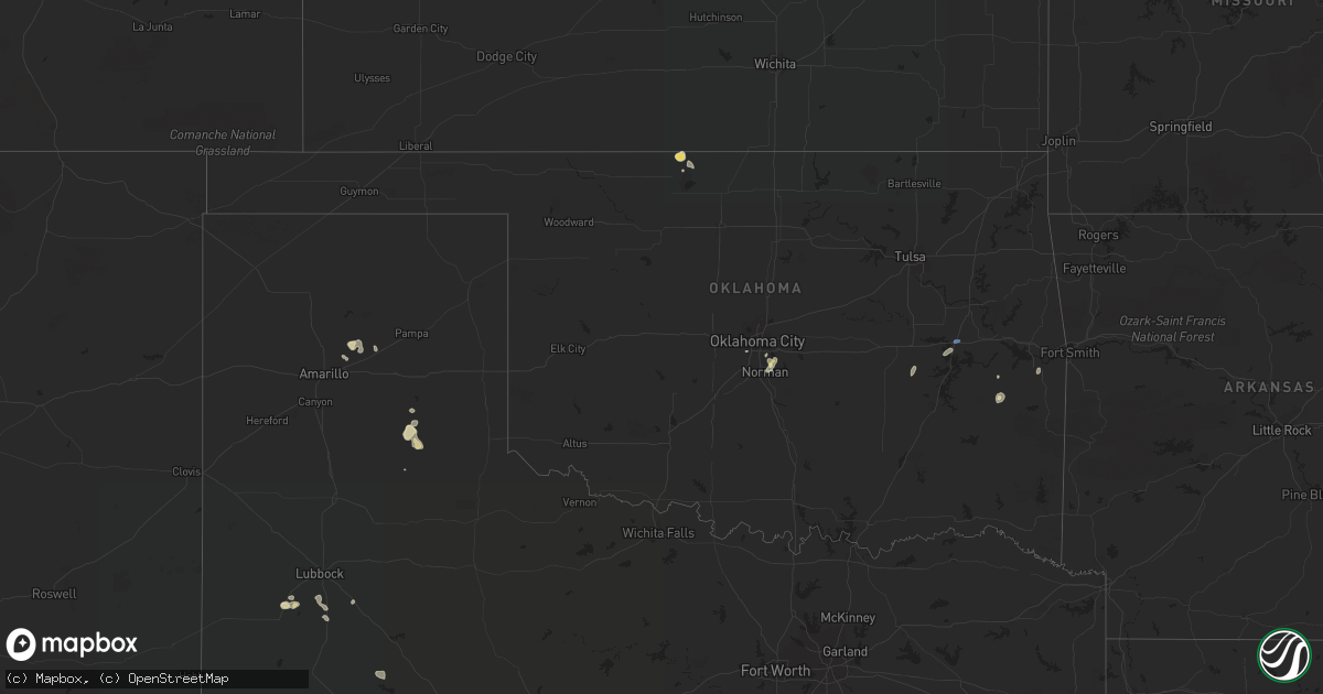
Hail Map in Oklahoma on August 28, 2022
Get this storm
August 28 map
$229
one time, instant access
Download today. No call, no setup
Keep the $229
Bought the map and want the full workflow? Apply the entire $229 to a subscription within 7 days. None of it is wasted.
Every map, not just this one
This buys you this map. Subscription and you get every map we run, in the markets you choose from a few cities to whole states to nationwide. Plus real-time alerts the moment a storm fires.
Contact data
Name, contact info, occupancy, even credit band for addresses in the footprint. You go from where it hit to who to call.
Become the source they trust
Unlimited branding weather history reports on demand. You already have the documented answer ready for the property owner, and you are the one who showed up with it.
Property data and RoofTrace estimates
Pull up any address you have got, its value and the exact code rules for that jurisdiction, straight from One Click Code. Then RoofTrace estimates the squares, pitch, and roof value, priced the way you price.
Storm reports in Oklahoma
Oklahoma
| Date | Description |
|---|---|
| 08/28/20225:09 PM CDT | A local report indicates 61 MPH wind near 5 SE DOVER |
| 08/28/20224:52 PM CDT | Power poles/lines down near onapa. Time estimated from radar. |
| 08/28/20224:48 PM CDT | Shingles blown off roof. |
| 08/28/20223:28 PM CDT | A local report indicates 64 MPH wind near CHECOTAH |
| 08/28/20222:51 PM CDT | A local report indicates 1.00 inch wind near 4 SSW STANLEY DRAPER LA |
| 08/28/20222:41 PM CDT | A local report indicates 73 MPH wind near 2 ENE NORMAN |
| 08/28/20222:54 AM CDT | At 754 PM CDT, severe thunderstorms were located along a line extending from 5 miles southeast of Davenport to 5 miles northwest of Meeker to near Choctaw, moving east at 15 mph. HAZARD...60 mph wind gusts and quarter size hail. SOURCE...Radar indicated. IMPACT...Hail damage to vehicles is expected. Expect wind damage to roofs, siding, and trees. Locations impacted include... Northeastern Oklahoma City, Midwest City, Shawnee, Chandler, Choctaw, Harrah, McLoud, Spencer, Jones, Stroud, Nicoma Park, Prague, Luther, Meeker, Davenport, Wellston, Sparks, Warwick and Aydelotte. |
| 08/28/20222:26 AM CDT | At 726 PM CDT, a severe thunderstorm was located near Geary, moving east at 15 mph. HAZARD...60 mph wind gusts and quarter size hail. SOURCE...Radar indicated. IMPACT...Hail damage to vehicles is expected. Expect wind damage to roofs, siding, and trees. Locations impacted include... Geary, Calumet and Greenfield. |
| 08/28/20222:25 AM CDT | At 725 PM CDT, a severe thunderstorm was located near Jones, moving east at 20 mph. HAZARD...60 mph wind gusts and quarter size hail. SOURCE...Radar indicated. IMPACT...Hail damage to vehicles is expected. Expect wind damage to roofs, siding, and trees. Locations impacted include... Northeastern Oklahoma City, Edmond, Midwest City, Choctaw, Harrah, Spencer, Jones, Nicoma Park, Luther, Wellston, Arcadia and Forest Park. |
| 08/28/20222:14 AM CDT | At 713 PM CDT, a severe thunderstorm was located near Byron, moving east at 15 mph. Another severe storm was located 8 miles north of the Great Salt Plains Lake. HAZARD...60 mph wind gusts and quarter size hail. SOURCE...Radar indicated. IMPACT...Hail damage to vehicles is expected. Expect wind damage to roofs, siding, and trees. Locations impacted include... Manchester, Amorita, Byron, Driftwood, northern Great Salt Plains Lake and Waldron. |
| 08/28/20222:12 AM CDT | At 712 PM CDT, a severe thunderstorm was located near Chandler, moving east at 15 mph. HAZARD...60 mph wind gusts and quarter size hail. SOURCE...Radar indicated. IMPACT...Hail damage to vehicles is expected. Expect wind damage to roofs, siding, and trees. Locations impacted include... Chandler, Stroud, Davenport, Sparks, Warwick and Kendrick. |
| 08/28/20221:48 AM CDT | At 648 PM CDT, a severe thunderstorm was located over northern Oklahoma City, or near Downtown Edmond, moving southeast at 20 mph. HAZARD...60 mph wind gusts and quarter size hail. SOURCE...Radar indicated. IMPACT...Hail damage to vehicles is expected. Expect wind damage to roofs, siding, and trees. Locations impacted include... Oklahoma City, Edmond, Midwest City, Del City, Choctaw, The Village, Spencer, Nichols Hills, Jones, Nicoma Park, Forest Park, Lake Aluma and Smith Village. |
| 08/28/20221:38 AM CDT | At 638 PM CDT, a severe thunderstorm was located near Davenport, moving northeast at 15 mph. HAZARD...60 mph wind gusts and half dollar size hail. SOURCE...Radar indicated. IMPACT...Hail damage to vehicles is expected. Expect wind damage to roofs, siding, and trees. Locations impacted include... Chandler, Stroud, Davenport, Sparks and Kendrick. |
| 08/28/202212:39 AM CDT | At 539 PM CDT, a severe thunderstorm was located near Guthrie, moving east at 25 mph. HAZARD...60 mph wind gusts and half dollar size hail. SOURCE...Radar indicated. IMPACT...Hail damage to vehicles is expected. Expect wind damage to roofs, siding, and trees. Locations impacted include... Guthrie, Langston, Crescent, Cashion, Coyle, Cedar Valley, Cimarron City, Meridian, Navina and Seward. |
| 08/28/202212:06 AM CDT | At 506 PM CDT, a severe thunderstorm was located 4 miles northeast of Kingfisher, moving northeast at 20 mph. HAZARD...60 mph wind gusts and half dollar size hail. SOURCE...Radar indicated. IMPACT...Hail damage to vehicles is expected. Expect wind damage to roofs, siding, and trees. Locations impacted include... Kingfisher and Dover. |
| 08/27/202211:51 PM CDT | At 450 PM CDT, severe thunderstorms were located along a line extending from near Lake Mcmurtry to 5 miles east of Lovell to near Cimarron City to 3 miles southwest of Bison, moving northeast at 15 mph. HAZARD...Ping pong ball size hail and 60 mph wind gusts. SOURCE...Radar indicated. IMPACT...People and animals outdoors will be injured. Expect hail damage to roofs, siding, windows, and vehicles. Expect wind damage to roofs, siding, and trees. Locations impacted include... Stillwater, Guthrie, Perry, Hennessey, Langston, Crescent, Cashion, Covington, Coyle, Cedar Valley, Marshall, Mulhall, Cimarron City, Orlando, Douglas, Lake Carl Blackwell, Lake Mcmurtry, Lovell, Lucien and Bison. |
| 08/27/202211:17 PM CDT | At 417 PM CDT, severe thunderstorms were located along a line extending from 5 miles west of Mulhall to 3 miles west of Crescent to 5 miles east of Hennessey, moving northeast at 25 mph. HAZARD...60 mph wind gusts and quarter size hail. SOURCE...Radar indicated. IMPACT...Hail damage to vehicles is expected. Expect wind damage to roofs, siding, and trees. Locations impacted include... Crescent, Covington, Marshall, Mulhall, Orlando, Douglas, Lake Carl Blackwell, Lovell, Lake Mcmurtry, Lucien and Hayward. |
| 08/27/202211:02 PM CDT | At 402 PM CDT, a severe thunderstorm was located over Hennessey, moving northeast at 20 mph. HAZARD...60 mph wind gusts and half dollar size hail. SOURCE...Radar indicated. IMPACT...Hail damage to vehicles is expected. Expect wind damage to roofs, siding, and trees. Locations impacted include... Hennessey, Waukomis and Bison. |
| 08/27/202210:18 PM CDT | At 318 PM CDT, a severe thunderstorm was located 4 miles southeast of Dover, moving northeast at 20 mph. HAZARD...60 mph wind gusts and quarter size hail. SOURCE...Radar indicated. IMPACT...Hail damage to vehicles is expected. Expect wind damage to roofs, siding, and trees. Locations impacted include... Dover, Marshall and Lovell. |
| 08/27/202210:17 PM CDT | At 317 PM CDT, a severe thunderstorm was located over northeastern Oklahoma City, or 4 miles north of Spencer, moving northeast at 15 mph. HAZARD...60 mph wind gusts and quarter size hail. SOURCE...Radar indicated. IMPACT...Hail damage to vehicles is expected. Expect wind damage to roofs, siding, and trees. Locations impacted include... Northeastern Oklahoma City, Edmond, Midwest City, Choctaw, Spencer, Jones, Nicoma Park, Luther, Arcadia, Forest Park and Lake Aluma. |
| 08/27/202210:06 PM CDT | At 306 PM CDT, a severe thunderstorm was located 3 miles east of Lake Eufaula State Park, moving northeast at 25 mph. HAZARD...60 mph wind gusts and quarter size hail. SOURCE...Radar indicated. IMPACT...Hail damage to vehicles is expected. Expect wind damage to roofs, siding, and trees. Locations in or near the path include... Checotah... Warner... Webbers Falls... Oktaha... Rentiesville... Lake Eufaula State Park... Keefeton... Onapa...This includes Interstate 40 in Oklahoma between mile markers 256 and283. |
| 08/27/20229:43 PM CDT | At 243 PM CDT, a severe thunderstorm was located over northern Norman, or 5 miles south of Stanley Draper Lake, moving northeast at 15 mph. HAZARD...60 mph wind gusts and quarter size hail. SOURCE...Radar indicated. IMPACT...Hail damage to vehicles is expected. Expect wind damage to roofs, siding, and trees. Locations impacted include... Southeastern Oklahoma City, Norman, Stella, northern Lake Thunderbird and Stanley Draper Lake. |
| 08/27/20228:00 PM CDT | Roof damage to el reno vfw. Time is estimated. |
| 08/27/20227:40 PM CDT | Corrects previous non-tstm wnd dmg report from 3 wnw geary. Barn and power poles damaged. |
| 08/27/20227:09 PM CDT | Snapped power poles. |
All States Impacted by Hail Map on August 28, 2022
Cities Impacted by Hail Map on August 28, 2022
- Andover, MN
- Minneapolis, MN
- Howard Lake, MN
- Bigfork, MN
- Ypsilanti, ND
- Marion, ND
- Downs, KS
- Osborne, KS
- Kimball, MN
- Eden Valley, MN
- Paynesville, MN
- Richmond, MN
- Watkins, MN
- South Haven, MN
- Cold Spring, MN
- Hinckley, MN
- Tahoka, TX
- White Deer, TX
- Panhandle, TX
- Fingal, ND
- Kathryn, ND
- Dexter, IA
- Stuart, IA
- Casey, IA
- Exira, IA
- Menlo, IA
- Adair, IA
- Anita, IA
- La Pointe, WI
- Tennessee Ridge, TN
- Stewart, TN
- Loudon, TN
- Philadelphia, TN
- Ludlow, IL
- Paxton, IL
- Thomasboro, IL
- Rantoul, IL
- Urbana, IL
- Loda, IL
- Gifford, IL
- Rankin, IL
- Saint Joseph, IL
- Pulaski, WI
- Norman, OK
- Brownfield, TX
- Meadow, TX
- Clarendon, TX
- Sterling, IL
- Bensenville, IL
- Pine City, MN
- Brook Park, MN
- Medford, WI
- Webster, WI
- Columbia, MO
- Merrill, WI
- Weyerhaeuser, WI
- Bruce, WI
- Exeland, WI
- Argyle, MO
- Meta, MO
- Suamico, WI
- Midkiff, TX
- Cook, MN
- Mountain, WI
- Mcintosh, MN
- Fosston, MN
- Buffalo, ND
- Andrews, TX
- Clara City, MN
- Monahans, TX
- Nome, ND
- Litchville, ND
- Van Buren, AR
- Fort Smith, AR
- Ladysmith, WI
- Jonesville, SC
- Sharon, SC
- Two Harbors, MN
- Grand Rapids, MN
- Bovey, MN
- Cohasset, MN
- Cerro Gordo, IL
- Milmine, IL
- Hammond, IL
- Gilman, WI
- Sheldon, WI
- Springerton, IL
- McLeansboro, IL
- Valley City, ND
- Quitaque, TX
- Hancock, IA
- Oakland, IA
- Minden, IA
- Argenta, IL
- Harlan, IA
- Lebanon, MO
- Elkhorn, NE
- Brazil, IN
- Cory, IN
- Centerpoint, IN
- Big Rock, IL
- Leland, IL
- Sandwich, IL
- Somonauk, IL
- Hinckley, IL
- Elburn, IL
- Annandale, MN
- Winger, MN
- Waterman, IL
- Shabbona, IL
- Dekalb, IL
- Stigler, OK
- Alborn, MN
- McClelland, IA
- Marshall, IL
- Dennison, IL
- Ten Mile, TN
- Makinen, MN
- Withee, WI
- Yale, IL
- Willow Hill, IL
- Littlefork, MN
- Big Falls, MN
- Panama, IA
- Westphalia, IA
- Portsmouth, IA
- Earling, IA
- Oakland, IL
- Crivitz, WI
- Pound, WI
- White Lake, WI
- Chamois, MO
- Bland, MO
- Linn, MO
- Wyoming, MN
- Polo, IL
- Chadwick, IL
- Lyndon, IL
- Morrison, IL
- Milledgeville, IL
- Sweetwater, TN
- Westboro, WI
- Ogema, WI
- Mora, MN
- Grasston, MN
- Goldsmith, TX
- Park Ridge, IL
- Niles, IL
- Morton Grove, IL
- Chicago, IL
- Martinsville, IL
- Hanna, OK
- Federal Dam, MN
- Catawba, WI
- Sandstone, MN
- Raymond, MN
- Mikana, WI
- Rice Lake, WI
- Anderson, SC
- Oklahoma City, OK
- Cotton, MN
- Gleason, WI
- Lublin, WI
- Athens, WI
- Rib Lake, WI
- Deerbrook, WI
- Tomahawk, WI
- Antigo, WI
- Irma, WI
- Thorp, WI
- Maple Park, IL
- Cortland, IL
- Earlville, IL
- Lee, IL
- Paw Paw, IL
- Hawkins, WI
- Glen Flora, WI
- Conrath, WI
- Kennan, WI
- Tony, WI
- Holcombe, WI
- Amorita, OK
- Burlington, OK
- Bison, KS
- Harmon, IL
- Cameron, WI
- Longville, MN
- Post, TX
- Fort Ransom, ND
- Remer, MN
- Walker, MN
- Kelliher, MN
- Blackduck, MN
- Redby, MN
- Watertown, MN
- Mayer, MN
- Wilson, TX
- Grantsburg, WI
- Wright, MN
- Floodwood, MN
- Waverly, MN
- Buffalo, MN
- Bokoshe, OK
- Spiro, OK
- Birchwood, WI
- Waterloo, NE
- Amarillo, TX
- Omaha, NE
- Wink, TX
- Warba, MN
- Deer River, MN
- Akeley, MN
- Hackensack, MN
- Nevis, MN
- Newton, IL
- Danbury, WI
- Wabeno, WI
- Fort Calhoun, NE
- Lisbon, ND
- Enderlin, ND
- Ponemah, MN
- Lakeview, TX
- Hines, MN
- Shell Lake, WI
- Sarona, WI
- Barronett, WI
- Glencoe, MN
- Brownton, MN
- New Germany, MN
- Malden, IL
- Olney, IL
- Woodbine, IA
- Plymouth, IN
- Walkerton, IN
- Bena, MN
- Kennard, NE
- Washington, NE
- Blair, NE
- Arlington, NE
- Bennington, NE
- Valley, NE
- Poland, IN
- Coal City, IN
- Patricksburg, IN
- Bowling Green, IN
- Arlington, IL
- La Moille, IL
- Coyanosa, TX
- Griswold, IA
- Kermit, TX
- Malta, IL
- Clare, IL
- Sycamore, IL
- Rochelle, IL
- Steward, IL
- Golden Gate, IL
- Parkersburg, IL
- West Salem, IL
- Mount Erie, IL
- Comstock, WI
- Cumberland, WI
- Long Lake, MN
- Wayzata, MN
- Ashmore, IL
- Charleston, IL
- Brocton, IL
- Gully, MN
- Gail, TX
- Red Oak, OK
- Green Bay, WI
- Henriette, MN
- Clearwater, MN
- Maple Lake, MN
- Monticello, MN
- Hopkins, MN
- Gonvick, MN
- Chetek, WI
- Little Suamico, WI
- Eufaula, OK
- Checotah, OK
- Clearbrook, MN
- Prinsburg, MN
- Maynard, MN
- Blomkest, MN
- Lake Lillian, MN
- Northome, MN


