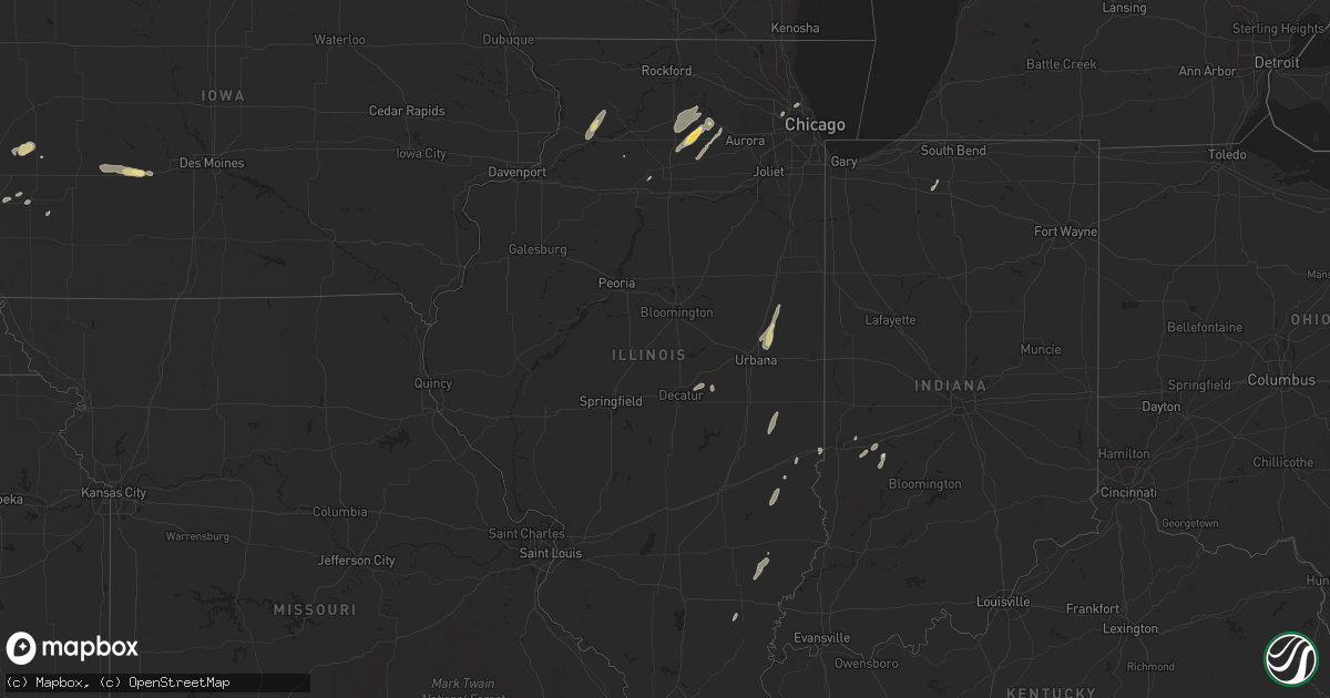
Hail Map in Illinois on August 28, 2022
Get this storm
August 28 map
$229
one time, instant access
Download today. No call, no setup
Keep the $229
Bought the map and want the full workflow? Apply the entire $229 to a subscription within 7 days. None of it is wasted.
Every map, not just this one
This buys you this map. Subscription and you get every map we run, in the markets you choose from a few cities to whole states to nationwide. Plus real-time alerts the moment a storm fires.
Contact data
Name, contact info, occupancy, even credit band for addresses in the footprint. You go from where it hit to who to call.
Become the source they trust
Unlimited branding weather history reports on demand. You already have the documented answer ready for the property owner, and you are the one who showed up with it.
Property data and RoofTrace estimates
Pull up any address you have got, its value and the exact code rules for that jurisdiction, straight from One Click Code. Then RoofTrace estimates the squares, pitch, and roof value, priced the way you price.
Storm reports in Illinois
Illinois
| Date | Description |
|---|---|
| 08/28/20224:20 PM CDT | Reports of two tents blown over at the dekalb cornfest. Time estimate. |
| 08/28/20224:20 PM CDT | Multiple sign poles bent over due to wind. Near somonauk road and route 38. |
| 08/28/20224:20 PM CDT | Twitter report of large limb down on the niu campus. Time estimate. |
| 08/28/20224:12 PM CDT | Relayed via spotter network. |
| 08/28/20224:05 PM CDT | Photo shows metal outbuilding/farm building destroyed. Time estimated. |
| 08/28/20223:50 PM CDT | Tree limbs down. Relayed via spotter network. |
| 08/28/20223:24 PM CDT | Multiple large tree limbs down near 10th avenue and lincoln highway. Time estimate. |
| 08/28/20223:23 PM CDT | Additional large tree limbs down on 9th avenue and 9th street. Estimated 8 to 12 inches in diameter. Time estimate. |
| 08/28/20223:19 PM CDT | Photos shared of large live tree mostly uprooted and a few large limbs down. Time estimate. |
| 08/28/20222:30 PM CDT | Tree down on rock grove road. Time estimated from radar. |
| 08/28/20222:22 PM CDT | Report of a 5 inch thick 15 foot long tree limb down. Numerous other limbs down. Time estimate. |
| 08/28/20221:45 PM CDT | A couple of trees were reported down in this area. Time estimated by radar. |
| 08/28/20223:52 AM CDT | At 851 PM CDT, a severe thunderstorm was located over mainly rural areas of Coles County, near Oakland, moving northeast at 35 mph. HAZARD...60 mph wind gusts and quarter size hail. SOURCE...Radar indicated. IMPACT...Hail damage to vehicles is expected. Expect wind damage to roofs, siding, and trees. This severe thunderstorm will be near... Brocton around 900 PM CDT. Newman around 905 PM CDT. Hume around 910 PM CDT.Other locations impacted by this severe thunderstorm include Isabel,Metcalf and Palermo. |
| 08/28/20223:27 AM CDT | At 825 PM CDT, a severe thunderstorm was located 7 miles south of Hazel Dell, or 12 miles northeast of Newton, moving northeast at 40 mph. HAZARD...60 mph wind gusts and quarter size hail. SOURCE...Radar indicated. IMPACT...Hail damage to vehicles is expected. Expect wind damage to roofs, siding, and trees. This severe thunderstorm will be near... Annapolis around 835 PM CDT. Casey around 845 PM CDT. Martinsville around 855 PM CDT.Other locations impacted by this severe thunderstorm include Yale,Orange and Bellair.This includes Interstate 70 between mile markers 131 and 136. |
| 08/28/20222:33 AM CDT | At 732 PM CDT, severe thunderstorms were located along a line extending from near Buckley to near Potomac, moving northeast at 35 mph. HAZARD...60 mph wind gusts and quarter size hail. SOURCE...Radar indicated. IMPACT...Hail damage to vehicles is expected. Expect wind damage to roofs, siding, and trees. Locations impacted include... Gilman, Milford, Onarga, Cissna Park, Buckley, Crescent City, Loda, Woodland, Wellington, Clarence and Claytonville.Including the following interstate... I-57 between mile markers 267 and 278. |
| 08/28/20221:44 AM CDT | At 643 PM CDT, a severe thunderstorm was located over Bensenville, or over Ohare Airport, moving northeast at 45 mph. HAZARD...60 mph wind gusts and quarter size hail. SOURCE...Radar indicated. IMPACT...Hail damage to vehicles is expected. Expect wind damage to roofs, siding, and trees. Locations impacted include... Chicago, Arlington Heights, Evanston, Skokie, Des Plaines, Mount Prospect, Glenview, Elmhurst, Ohare Airport, Park Ridge, Addison, Northbrook, Elk Grove Village, Niles, Irving Park, West Ridge, Austin, Wilmette, Melrose Park and Maywood.Including the following interstates... I-88 between mile markers 139 and 140. I-90 between mile markers 71 and 84. I-94 between mile markers 29 and 45. I-290 between mile markers 3 and 17. I-294 between mile markers 29 and 45.This includes... Loyola University, Oakton Community College, TritonCollege, Northeastern Illinois University, and NorthwesternUniversity. |
| 08/27/202211:32 PM CDT | At 432 PM CDT, a severe thunderstorm was located over Kemper, moving northeast at 35 mph. HAZARD...60 mph wind gusts. SOURCE...Radar indicated. IMPACT...Expect damage to roofs, siding, and trees. Locations impacted include... Carlinville and Palmyra. |
| 08/27/202211:30 PM CDT | At 430 PM CDT, severe thunderstorms were located along a line extending from near Hinckley to Sandwich, moving northeast at 45 mph. HAZARD...60 mph wind gusts. SOURCE...Radar indicated. IMPACT...Expect damage to roofs, siding, and trees. Severe thunderstorms will be near... Plano around 435 PM CDT. Yorkville around 440 PM CDT. Sugar Grove and Maple Park around 445 PM CDT. Aurora, Montgomery and Elburn around 450 PM CDT. Campton Hills, North Aurora and Lily Lake around 455 PM CDT. St. Charles, Batavia and Geneva around 500 PM CDT. Bartlett, West Chicago, South Elgin, Wayne and Valley View around 505 PM CDT. Elgin around 510 PM CDT.Other locations impacted by these severe thunderstorms includeKaneville, Little Rock, Big Rock and Virgil.Including the following interstates... I-88 between mile markers 102 and 120. I-90 between mile markers 55 and 56.This includes... Aurora University, Elgin Community College,Fermilab, IL Math and Science Academy, Kane County Cougars Ballpark,and Waubonsee Community College. |
| 08/27/202211:13 PM CDT | At 413 PM CDT, severe thunderstorms were located along a line extending from Watertown to near Harvard, moving east at 55 mph. HAZARD...60 mph wind gusts and nickel size hail. SOURCE...Radar indicated. IMPACT...Expect damage to roofs, siding, and trees. Locations impacted include... Waukesha, New Berlin, Brookfield, Menomonee Falls, Muskego, Watertown, Antioch, Whitewater, Pewaukee, Sussex, Elkhorn, Hartland, Delavan, Lake Geneva, Mukwonago, Delafield, Elm Grove, Union Grove, East Troy and Paddock Lake.This includes the following Locations Pewaukee Lake, Ottawa LakeRecreation Area, and Pinewoods Campground. |
| 08/27/202211:13 PM CDT | At 413 PM CDT, severe thunderstorms were located along a line extending from near Hampshire to 6 miles east of Sycamore, moving northeast at 35 mph. HAZARD...60 mph wind gusts. SOURCE...Radar indicated. IMPACT...Expect damage to roofs, siding, and trees. Severe thunderstorms will be near... Hampshire around 420 PM CDT. Huntley around 425 PM CDT. Pingree Grove around 430 PM CDT. Gilberts and Lakewood around 435 PM CDT. Elgin, Crystal Lake, Lake in the Hills, West Dundee and Sleepy Hollow around 440 PM CDT. Carpentersville, Algonquin, Cary, Barrington Hills, East Dundee, Oakwood Hills and Prairie Grove around 445 PM CDT. McHenry, Island Lake, Fox River Grove and Port Barrington around 450 PM CDT. Lakemoor around 455 PM CDT.Other locations impacted by these severe thunderstorms include TroutValley, Burlington, Holiday Hills, Ridgefield and Virgil.Including the following interstate... I-90 between mile markers 40 and 55. This includes... Mchenry County College and Moraine Hills StatePark. |
| 08/27/202210:29 PM CDT | At 329 PM CDT, severe thunderstorms were located along a line extending from McFarland to near South Beloit, moving northeast at 45 mph. HAZARD...60 mph wind gusts and nickel size hail. SOURCE...Radar indicated. IMPACT...Expect damage to roofs, siding, and trees. Locations impacted include... Janesville, Watertown, Whitewater, Fort Atkinson, Elkhorn, Delavan, Jefferson, Lake Geneva, Lake Mills, Milton, East Troy, Waterloo, Williams Bay, Walworth, Johnson Creek, Clinton, Palmyra, Fontana-On-Geneva Lake, Sharon and Darien.People attending The UW-Whitewater Move In should seek safe shelter immediately! |
| 08/27/202210:27 PM CDT | At 327 PM CDT, severe thunderstorms were located along a line extending from near Machesney Park to near Cherry Valley to 6 miles northeast of Hillcrest, moving northeast at 35 mph. HAZARD...60 mph wind gusts and penny size hail. SOURCE...Radar indicated. IMPACT...Expect damage to roofs, siding, and trees. Severe thunderstorms will be near... Belvidere and Cherry Valley around 330 PM CDT. Loves Park, Candlewick Lake and Timberlane around 335 PM CDT. Poplar Grove around 340 PM CDT. Kingston around 345 PM CDT. Capron around 350 PM CDT. Genoa around 355 PM CDT. Harvard around 400 PM CDT. Marengo around 410 PM CDT.Other locations impacted by these severe thunderstorms includeFairdale, Garden Prairie, Chemung, Union and Caledonia.Including the following interstate... I-90 between mile markers 19 and 40. This includes... Boone County Fairgrounds. |
| 08/27/202210:17 PM CDT | At 317 PM CDT, severe thunderstorms were located along a line extending from 7 miles southeast of Ashton to near Granville, moving northeast at 40 mph. HAZARD...60 mph wind gusts and penny size hail. SOURCE...Radar indicated. IMPACT...Expect damage to roofs, siding, and trees. Locations impacted include... DeKalb, Sycamore, Peru, La Salle, Sandwich, Mendota, Shabbona, Lake Holiday, Cortland, Oglesby, Hinckley, Somonauk, Earlville, Waterman, North Utica, Maple Park, Malta, Leland, Paw Paw and Lee.Including the following interstates... I-39 between mile markers 53 and 94. I-80 between mile markers 74 and 83. I-88 between mile markers 83 and 101.This includes... Northern Illinois University, Sandwich Fairgrounds,Illinois Valley Community College, and Tri-County Fairgrounds. |
| 08/27/20229:53 PM CDT | At 252 PM CDT, severe thunderstorms were located along a line extending from near New Glarus to near Monticello to near Lake Summerset, moving northeast at 50 mph. HAZARD...60 mph wind gusts and nickel size hail. SOURCE...Radar indicated. IMPACT...Expect damage to roofs, siding, and trees. Locations impacted include... Madison, Janesville, Beloit, Sun Prairie, Fitchburg, Stoughton, Monroe, Verona, Oregon, McFarland, Monona, Milton, Edgerton, Evansville, Marshall, Brodhead, Cottage Grove, Belleville, Deerfield and New Glarus.This includes the following Location Wisconsin State Capitol. |
| 08/27/20229:47 PM CDT | At 247 PM CDT, severe thunderstorms were located along a line extending from near Davis to 6 miles southeast of German Valley, moving northeast at 35 mph. HAZARD...60 mph wind gusts and penny size hail. SOURCE...Radar indicated. IMPACT...Expect damage to roofs, siding, and trees. Locations impacted include... Rockford, Loves Park, Machesney Park, Roscoe, South Beloit, Rockton, Rockford Airport, Cherry Valley, Winnebago, Davis Junction, Pecatonica, Durand, New Milford, Seward, Shirland, Lake Summerset and Harrison.Including the following interstates... I-39 between mile markers 115 and 123. I-90 between mile markers 1 and 18.This includes... Rock Cut State Park, Rock Valley College, RockfordAviators Baseball, Rockford Speedway, and Winnebago CountyFairgrounds. |
| 08/27/20229:39 PM CDT | At 238 PM CDT, severe thunderstorms were located along a line extending from near Mount Morris to 6 miles west of Woodhaven Lakes, moving northeast at 40 mph. HAZARD...60 mph wind gusts and penny size hail. SOURCE...Radar indicated. IMPACT...Expect damage to roofs, siding, and trees. Locations impacted include... Dixon, Rochelle, Byron, Oregon, Mount Morris, Amboy, Davis Junction, Hillcrest, Stillman Valley, Franklin Grove, Ashton, Lost Nation, Woodhaven Lakes, Creston, Lindenwood, Monroe Center, Grand Detour, Steward, Eldena and Lee Center.Including the following interstates... I-39 between mile markers 94 and 114. I-88 between mile markers 55 and 82.This includes... Castle Rock State Park, Lee County Fairgrounds,Lowden State Park, and Ogle County Fairgrounds. |
| 08/27/20229:17 PM CDT | At 216 PM CDT, severe thunderstorms were located along a line extending from Apple River to near Dakota, moving northeast at 50 mph. HAZARD...60 mph wind gusts and nickel size hail. SOURCE...Radar indicated. IMPACT...Expect damage to roofs, siding, and trees. Locations impacted include... Monroe, Brodhead, Darlington, New Glarus, Brooklyn, Monticello, Albany, Argyle, Blanchardville, Wiota, Dayton, South Wayne, Fayette, Lamont, Browntown, Gratiot, Attica, Juda, Jordan Center and Yellowstone Lake St Park.This includes the following Location York Memorial Church. |
| 08/27/20229:08 PM CDT | At 208 PM CDT, a severe thunderstorm was located near Milledgeville, or near Polo, moving northeast at 45 mph. HAZARD...60 mph wind gusts and penny size hail. SOURCE...Radar indicated. IMPACT...Expect damage to roofs, siding, and trees. Locations impacted include... Polo, Forreston, Leaf River, Adeline and Baileyville. |
| 08/27/20229:01 PM CDT | At 200 PM CDT, a severe thunderstorm was located over Malvern, or 7 miles northeast of Morrison, moving northeast at 40 mph. HAZARD...60 mph wind gusts and penny size hail. SOURCE...Radar indicated. IMPACT...Expect damage to roofs, siding, and trees. This severe thunderstorm will be near... Coleta around 205 PM CDT. Penrose around 210 PM CDT. Milledgeville, Carroll County Fairgrounds and Hitt around 215 PM CDT. |
| 08/27/20228:44 PM CDT | At 144 PM CDT, a severe thunderstorm was located near Loran, or near Mount Carroll, moving northeast at 30 mph. HAZARD...60 mph wind gusts and nickel size hail. SOURCE...Radar indicated. IMPACT...Expect damage to roofs, siding, and trees. This severe thunderstorm will be near... Loran around 155 PM CDT. Willow around 200 PM CDT.Other locations in the path of this severe thunderstorm include PearlCity, Kent, Bolton, Eleroy, Lena, Lake Le-Aqua-na State Park, Damascus, Waddams Grove, Scioto Mills, Cedarville andRed Oak. |
All States Impacted by Hail Map on August 28, 2022
Cities Impacted by Hail Map on August 28, 2022
- Andover, MN
- Minneapolis, MN
- Howard Lake, MN
- Bigfork, MN
- Ypsilanti, ND
- Marion, ND
- Downs, KS
- Osborne, KS
- Kimball, MN
- Eden Valley, MN
- Paynesville, MN
- Richmond, MN
- Watkins, MN
- South Haven, MN
- Cold Spring, MN
- Hinckley, MN
- Tahoka, TX
- White Deer, TX
- Panhandle, TX
- Fingal, ND
- Kathryn, ND
- Dexter, IA
- Stuart, IA
- Casey, IA
- Exira, IA
- Menlo, IA
- Adair, IA
- Anita, IA
- La Pointe, WI
- Tennessee Ridge, TN
- Stewart, TN
- Loudon, TN
- Philadelphia, TN
- Ludlow, IL
- Paxton, IL
- Thomasboro, IL
- Rantoul, IL
- Urbana, IL
- Loda, IL
- Gifford, IL
- Rankin, IL
- Saint Joseph, IL
- Pulaski, WI
- Norman, OK
- Brownfield, TX
- Meadow, TX
- Clarendon, TX
- Sterling, IL
- Bensenville, IL
- Pine City, MN
- Brook Park, MN
- Medford, WI
- Webster, WI
- Columbia, MO
- Merrill, WI
- Weyerhaeuser, WI
- Bruce, WI
- Exeland, WI
- Argyle, MO
- Meta, MO
- Suamico, WI
- Midkiff, TX
- Cook, MN
- Mountain, WI
- Mcintosh, MN
- Fosston, MN
- Buffalo, ND
- Andrews, TX
- Clara City, MN
- Monahans, TX
- Nome, ND
- Litchville, ND
- Van Buren, AR
- Fort Smith, AR
- Ladysmith, WI
- Jonesville, SC
- Sharon, SC
- Two Harbors, MN
- Grand Rapids, MN
- Bovey, MN
- Cohasset, MN
- Cerro Gordo, IL
- Milmine, IL
- Hammond, IL
- Gilman, WI
- Sheldon, WI
- Springerton, IL
- McLeansboro, IL
- Valley City, ND
- Quitaque, TX
- Hancock, IA
- Oakland, IA
- Minden, IA
- Argenta, IL
- Harlan, IA
- Lebanon, MO
- Elkhorn, NE
- Brazil, IN
- Cory, IN
- Centerpoint, IN
- Big Rock, IL
- Leland, IL
- Sandwich, IL
- Somonauk, IL
- Hinckley, IL
- Elburn, IL
- Annandale, MN
- Winger, MN
- Waterman, IL
- Shabbona, IL
- Dekalb, IL
- Stigler, OK
- Alborn, MN
- McClelland, IA
- Marshall, IL
- Dennison, IL
- Ten Mile, TN
- Makinen, MN
- Withee, WI
- Yale, IL
- Willow Hill, IL
- Littlefork, MN
- Big Falls, MN
- Panama, IA
- Westphalia, IA
- Portsmouth, IA
- Earling, IA
- Oakland, IL
- Crivitz, WI
- Pound, WI
- White Lake, WI
- Chamois, MO
- Bland, MO
- Linn, MO
- Wyoming, MN
- Polo, IL
- Chadwick, IL
- Lyndon, IL
- Morrison, IL
- Milledgeville, IL
- Sweetwater, TN
- Westboro, WI
- Ogema, WI
- Mora, MN
- Grasston, MN
- Goldsmith, TX
- Park Ridge, IL
- Niles, IL
- Morton Grove, IL
- Chicago, IL
- Martinsville, IL
- Hanna, OK
- Federal Dam, MN
- Catawba, WI
- Sandstone, MN
- Raymond, MN
- Mikana, WI
- Rice Lake, WI
- Anderson, SC
- Oklahoma City, OK
- Cotton, MN
- Gleason, WI
- Lublin, WI
- Athens, WI
- Rib Lake, WI
- Deerbrook, WI
- Tomahawk, WI
- Antigo, WI
- Irma, WI
- Thorp, WI
- Maple Park, IL
- Cortland, IL
- Earlville, IL
- Lee, IL
- Paw Paw, IL
- Hawkins, WI
- Glen Flora, WI
- Conrath, WI
- Kennan, WI
- Tony, WI
- Holcombe, WI
- Amorita, OK
- Burlington, OK
- Bison, KS
- Harmon, IL
- Cameron, WI
- Longville, MN
- Post, TX
- Fort Ransom, ND
- Remer, MN
- Walker, MN
- Kelliher, MN
- Blackduck, MN
- Redby, MN
- Watertown, MN
- Mayer, MN
- Wilson, TX
- Grantsburg, WI
- Wright, MN
- Floodwood, MN
- Waverly, MN
- Buffalo, MN
- Bokoshe, OK
- Spiro, OK
- Birchwood, WI
- Waterloo, NE
- Amarillo, TX
- Omaha, NE
- Wink, TX
- Warba, MN
- Deer River, MN
- Akeley, MN
- Hackensack, MN
- Nevis, MN
- Newton, IL
- Danbury, WI
- Wabeno, WI
- Fort Calhoun, NE
- Lisbon, ND
- Enderlin, ND
- Ponemah, MN
- Lakeview, TX
- Hines, MN
- Shell Lake, WI
- Sarona, WI
- Barronett, WI
- Glencoe, MN
- Brownton, MN
- New Germany, MN
- Malden, IL
- Olney, IL
- Woodbine, IA
- Plymouth, IN
- Walkerton, IN
- Bena, MN
- Kennard, NE
- Washington, NE
- Blair, NE
- Arlington, NE
- Bennington, NE
- Valley, NE
- Poland, IN
- Coal City, IN
- Patricksburg, IN
- Bowling Green, IN
- Arlington, IL
- La Moille, IL
- Coyanosa, TX
- Griswold, IA
- Kermit, TX
- Malta, IL
- Clare, IL
- Sycamore, IL
- Rochelle, IL
- Steward, IL
- Golden Gate, IL
- Parkersburg, IL
- West Salem, IL
- Mount Erie, IL
- Comstock, WI
- Cumberland, WI
- Long Lake, MN
- Wayzata, MN
- Ashmore, IL
- Charleston, IL
- Brocton, IL
- Gully, MN
- Gail, TX
- Red Oak, OK
- Green Bay, WI
- Henriette, MN
- Clearwater, MN
- Maple Lake, MN
- Monticello, MN
- Hopkins, MN
- Gonvick, MN
- Chetek, WI
- Little Suamico, WI
- Eufaula, OK
- Checotah, OK
- Clearbrook, MN
- Prinsburg, MN
- Maynard, MN
- Blomkest, MN
- Lake Lillian, MN
- Northome, MN


