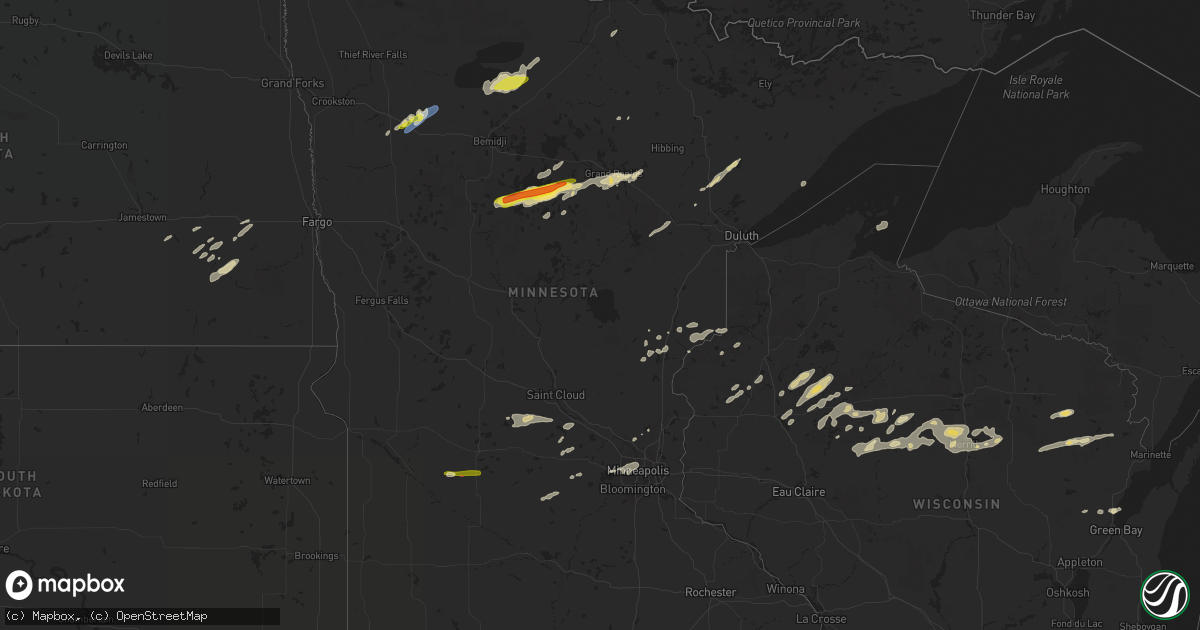
Hail Map in Minnesota on August 28, 2022
Get this storm
August 28 map
$229
one time, instant access
Download today. No call, no setup
Keep the $229
Bought the map and want the full workflow? Apply the entire $229 to a subscription within 7 days. None of it is wasted.
Every map, not just this one
This buys you this map. Subscription and you get every map we run, in the markets you choose from a few cities to whole states to nationwide. Plus real-time alerts the moment a storm fires.
Contact data
Name, contact info, occupancy, even credit band for addresses in the footprint. You go from where it hit to who to call.
Become the source they trust
Unlimited branding weather history reports on demand. You already have the documented answer ready for the property owner, and you are the one who showed up with it.
Property data and RoofTrace estimates
Pull up any address you have got, its value and the exact code rules for that jurisdiction, straight from One Click Code. Then RoofTrace estimates the squares, pitch, and roof value, priced the way you price.
Storm reports in Minnesota
Minnesota
| Date | Description |
|---|---|
| 08/28/20226:41 PM CDT | A few large 3 to 5 inch branches broken down. |
| 08/28/20226:35 PM CDT | Northern cormant twp. |
| 08/28/20226:35 PM CDT | Hail across northern cormant township. |
| 08/28/20224:20 PM CDT | Lots of dime to nickel size hail with a few as large as quarters. |
| 08/28/20224:17 PM CDT | Kfse gusted to 50 knots....gusts ongoing. |
| 08/28/20224:15 PM CDT | Peak winds at the fosston airport. Wind gusts continued through 417 pm cdt. |
| 08/28/20226:52 AM CDT | At 1152 PM CDT, a severe thunderstorm was located over Cloverton, or 29 miles northwest of Spooner, moving east at 40 mph. HAZARD...70 mph wind gusts and penny size hail. SOURCE...Radar indicated. IMPACT...Expect considerable tree damage. Damage is likely to mobile homes, roofs, and outbuildings. Locations impacted include... Hayward, Wascott, Webster, Solon Springs, Minong, Webb Lake Wisconsin, Gordon, Dairyland, Danbury, Cloverton, Oakland, Cozy Corner, Minong Flowage, Moose Junction, Birch Island Lake, Kingsdale, Lampson, Markville, Totagatic Flowage, and Stanberry. |
| 08/28/20226:21 AM CDT | At 1121 PM CDT, a severe thunderstorm was located over Whiteface Reservoir, or 38 miles east of Hibbing, moving northeast at 35 mph. HAZARD...Ping pong ball size hail and 60 mph wind gusts. SOURCE...Radar indicated. IMPACT...People and animals outdoors will be injured. Expect hail damage to roofs, siding, windows, and vehicles. Expect wind damage to roofs, siding, and trees. Locations impacted include... Fairbanks, Wolf Lake, Whyte, Whiteface Reservoir, Greenwood Lake, Seven Beaver Lake, Markham, Bassett Lake, and Skibo. |
| 08/28/20226:09 AM CDT | At 1109 PM CDT, a severe thunderstorm was located 7 miles east of Toivola, or 20 miles southeast of Hibbing, moving east at 20 mph. HAZARD...60 mph wind gusts and nickel size hail. SOURCE...Radar indicated. IMPACT...Expect damage to roofs, siding, and trees. Locations impacted include... Cotton, Meadowlands, Boulder Lake, Whiteface Reservoir, Makinen, Kelsey, Comstock Lake, Payne, Shaw, Nichols Lake, Melrude, Murphy Lake, and Markham. |
| 08/28/20224:51 AM CDT | At 951 PM CDT, a severe thunderstorm was located over Coleraine, or near Grand Rapids, moving east at 35 mph. HAZARD...60 mph wind gusts and quarter size hail. SOURCE...Radar indicated. IMPACT...Hail damage to vehicles is expected. Expect wind damage to roofs, siding, and trees. This severe thunderstorm will be near... Taconite around 1005 PM CDT.Other locations in the path of this severe thunderstorm includePengilly, Keewatin and Nashwauk. |
| 08/28/20224:38 AM CDT | At 938 PM CDT, severe thunderstorms were located along a line extending from 6 miles south of St. Cloud to 5 miles north of Kimball to Watkins, moving east at 30 mph. HAZARD...60 mph wind gusts and half dollar size hail. SOURCE...Radar indicated. IMPACT...Hail damage to vehicles is expected. Expect wind damage to roofs, siding, and trees. Severe thunderstorms will be near... St. Cloud around 955 PM CDT.Other locations in the path of these severe thunderstorms includeClear Lake, Annandale, Clearwater and Becker. |
| 08/28/20224:02 AM CDT | At 902 PM CDT, a severe thunderstorm was located near Paynesville, or 24 miles southwest of St. Cloud, moving east at 15 mph. HAZARD...60 mph wind gusts and quarter size hail. SOURCE...Radar indicated. IMPACT...Hail damage to vehicles is expected. Expect wind damage to roofs, siding, and trees. Locations impacted include... Richmond and Cold Spring. |
| 08/28/20223:57 AM CDT | At 857 PM CDT, a severe thunderstorm was located over Swanville, or 15 miles west of Little Falls, moving east at 25 mph. HAZARD...60 mph wind gusts and half dollar size hail. SOURCE...Radar indicated. IMPACT...Hail damage to vehicles is expected. Expect wind damage to roofs, siding, and trees. This severe thunderstorm will be near... Swanville around 900 PM CDT. Flensburg around 910 PM CDT.Other locations in the path of this severe thunderstorm includeLittle Falls. |
| 08/28/20223:43 AM CDT | At 841 PM CDT, a severe thunderstorm was located near Boy River, or 17 miles east of Walker, moving northeast at 35 mph. HAZARD...Two inch hail and 60 mph wind gusts. SOURCE...Radar indicated. IMPACT...People and animals outdoors will be injured. Expect hail damage to roofs, siding, windows, and vehicles. Expect wind damage to roofs, siding, and trees. This severe thunderstorm will be near... Boy River around 850 PM CDT.Other locations in the path of this severe thunderstorm include DaysHigh Landing, Deer River, Zemple and Pokegama Dam. |
| 08/28/20223:21 AM CDT | At 820 PM CDT, a severe thunderstorm was located near Fairfax, or 19 miles east of Redwood Falls, moving east at 20 mph. HAZARD...60 mph wind gusts and quarter size hail. SOURCE...Radar indicated. IMPACT...Hail damage to vehicles is expected. Expect wind damage to roofs, siding, and trees. Locations impacted include... Stewart. |
| 08/28/20222:58 AM CDT | At 758 PM CDT, a severe thunderstorm was located near Akeley, or near Walker, moving east at 45 mph. HAZARD...Ping pong ball size hail and 60 mph wind gusts. SOURCE...Radar indicated. IMPACT...People and animals outdoors will be injured. Expect hail damage to roofs, siding, windows, and vehicles. Expect wind damage to roofs, siding, and trees. This severe thunderstorm will be near... Walker around 805 PM CDT.Other locations in the path of this severe thunderstorm includeFederal Dam, Leech Lake and Boy River. |
| 08/28/20222:41 AM CDT | At 741 PM CDT, a severe thunderstorm was located over Clara City, or 17 miles east of Montevideo, moving east at 25 mph. HAZARD...60 mph wind gusts and half dollar size hail. SOURCE...Radar indicated. IMPACT...Hail damage to vehicles is expected. Expect wind damage to roofs, siding, and trees. This severe thunderstorm will be near... Raymond around 800 PM CDT.Other locations in the path of this severe thunderstorm includePrinsburg. |
| 08/28/20221:30 AM CDT | At 628 PM CDT, a severe thunderstorm was located 7 miles southwest of Kelliher, or 31 miles northeast of Bemidji, moving northeast at 35 mph. HAZARD...60 mph wind gusts and quarter size hail. SOURCE...Radar indicated. IMPACT...Hail damage to vehicles is expected. Expect wind damage to roofs, siding, and trees. Locations impacted include... Mizpah and Gemmell. |
| 08/28/20221:25 AM CDT | At 625 PM CDT, a severe thunderstorm was located near Saum, or 33 miles north of Bemidji, moving northeast at 35 mph. HAZARD...60 mph wind gusts and quarter size hail. SOURCE...Radar indicated. IMPACT...Hail damage to vehicles is expected. Expect wind damage to roofs, siding, and trees. This severe thunderstorm will be near... Kelliher and Shooks around 635 PM CDT. |
| 08/27/202211:16 PM CDT | At 416 PM CDT, a severe thunderstorm was located near Fosston, or 38 miles southeast of Thief River Falls, moving northeast at 50 mph. HAZARD...60 mph wind gusts and quarter size hail. SOURCE...Radar indicated. IMPACT...Hail damage to vehicles is expected. Expect wind damage to roofs, siding, and trees. This severe thunderstorm will be near... Olga and Trail around 425 PM CDT. Weme and Gully around 430 PM CDT. Gonvick, Clearbrook and Berner around 435 PM CDT.Other locations in the path of this severe thunderstorm includesouthwestern Lower Red Lake and Island Lake in Beltrami County. |
| 08/27/20228:50 PM CDT | A local report indicates 1.50 inch wind near BOY RIVER |
| 08/27/20228:40 PM CDT | A local report indicates 1.75 inch wind near BREVIK |
| 08/27/20228:03 PM CDT | Trained spotters reported tornado on the ground west of prinsburg. |
All States Impacted by Hail Map on August 28, 2022
Cities Impacted by Hail Map on August 28, 2022
- Andover, MN
- Minneapolis, MN
- Howard Lake, MN
- Bigfork, MN
- Ypsilanti, ND
- Marion, ND
- Downs, KS
- Osborne, KS
- Kimball, MN
- Eden Valley, MN
- Paynesville, MN
- Richmond, MN
- Watkins, MN
- South Haven, MN
- Cold Spring, MN
- Hinckley, MN
- Tahoka, TX
- White Deer, TX
- Panhandle, TX
- Fingal, ND
- Kathryn, ND
- Dexter, IA
- Stuart, IA
- Casey, IA
- Exira, IA
- Menlo, IA
- Adair, IA
- Anita, IA
- La Pointe, WI
- Tennessee Ridge, TN
- Stewart, TN
- Loudon, TN
- Philadelphia, TN
- Ludlow, IL
- Paxton, IL
- Thomasboro, IL
- Rantoul, IL
- Urbana, IL
- Loda, IL
- Gifford, IL
- Rankin, IL
- Saint Joseph, IL
- Pulaski, WI
- Norman, OK
- Brownfield, TX
- Meadow, TX
- Clarendon, TX
- Sterling, IL
- Bensenville, IL
- Pine City, MN
- Brook Park, MN
- Medford, WI
- Webster, WI
- Columbia, MO
- Merrill, WI
- Weyerhaeuser, WI
- Bruce, WI
- Exeland, WI
- Argyle, MO
- Meta, MO
- Suamico, WI
- Midkiff, TX
- Cook, MN
- Mountain, WI
- Mcintosh, MN
- Fosston, MN
- Buffalo, ND
- Andrews, TX
- Clara City, MN
- Monahans, TX
- Nome, ND
- Litchville, ND
- Van Buren, AR
- Fort Smith, AR
- Ladysmith, WI
- Jonesville, SC
- Sharon, SC
- Two Harbors, MN
- Grand Rapids, MN
- Bovey, MN
- Cohasset, MN
- Cerro Gordo, IL
- Milmine, IL
- Hammond, IL
- Gilman, WI
- Sheldon, WI
- Springerton, IL
- McLeansboro, IL
- Valley City, ND
- Quitaque, TX
- Hancock, IA
- Oakland, IA
- Minden, IA
- Argenta, IL
- Harlan, IA
- Lebanon, MO
- Elkhorn, NE
- Brazil, IN
- Cory, IN
- Centerpoint, IN
- Big Rock, IL
- Leland, IL
- Sandwich, IL
- Somonauk, IL
- Hinckley, IL
- Elburn, IL
- Annandale, MN
- Winger, MN
- Waterman, IL
- Shabbona, IL
- Dekalb, IL
- Stigler, OK
- Alborn, MN
- McClelland, IA
- Marshall, IL
- Dennison, IL
- Ten Mile, TN
- Makinen, MN
- Withee, WI
- Yale, IL
- Willow Hill, IL
- Littlefork, MN
- Big Falls, MN
- Panama, IA
- Westphalia, IA
- Portsmouth, IA
- Earling, IA
- Oakland, IL
- Crivitz, WI
- Pound, WI
- White Lake, WI
- Chamois, MO
- Bland, MO
- Linn, MO
- Wyoming, MN
- Polo, IL
- Chadwick, IL
- Lyndon, IL
- Morrison, IL
- Milledgeville, IL
- Sweetwater, TN
- Westboro, WI
- Ogema, WI
- Mora, MN
- Grasston, MN
- Goldsmith, TX
- Park Ridge, IL
- Niles, IL
- Morton Grove, IL
- Chicago, IL
- Martinsville, IL
- Hanna, OK
- Federal Dam, MN
- Catawba, WI
- Sandstone, MN
- Raymond, MN
- Mikana, WI
- Rice Lake, WI
- Anderson, SC
- Oklahoma City, OK
- Cotton, MN
- Gleason, WI
- Lublin, WI
- Athens, WI
- Rib Lake, WI
- Deerbrook, WI
- Tomahawk, WI
- Antigo, WI
- Irma, WI
- Thorp, WI
- Maple Park, IL
- Cortland, IL
- Earlville, IL
- Lee, IL
- Paw Paw, IL
- Hawkins, WI
- Glen Flora, WI
- Conrath, WI
- Kennan, WI
- Tony, WI
- Holcombe, WI
- Amorita, OK
- Burlington, OK
- Bison, KS
- Harmon, IL
- Cameron, WI
- Longville, MN
- Post, TX
- Fort Ransom, ND
- Remer, MN
- Walker, MN
- Kelliher, MN
- Blackduck, MN
- Redby, MN
- Watertown, MN
- Mayer, MN
- Wilson, TX
- Grantsburg, WI
- Wright, MN
- Floodwood, MN
- Waverly, MN
- Buffalo, MN
- Bokoshe, OK
- Spiro, OK
- Birchwood, WI
- Waterloo, NE
- Amarillo, TX
- Omaha, NE
- Wink, TX
- Warba, MN
- Deer River, MN
- Akeley, MN
- Hackensack, MN
- Nevis, MN
- Newton, IL
- Danbury, WI
- Wabeno, WI
- Fort Calhoun, NE
- Lisbon, ND
- Enderlin, ND
- Ponemah, MN
- Lakeview, TX
- Hines, MN
- Shell Lake, WI
- Sarona, WI
- Barronett, WI
- Glencoe, MN
- Brownton, MN
- New Germany, MN
- Malden, IL
- Olney, IL
- Woodbine, IA
- Plymouth, IN
- Walkerton, IN
- Bena, MN
- Kennard, NE
- Washington, NE
- Blair, NE
- Arlington, NE
- Bennington, NE
- Valley, NE
- Poland, IN
- Coal City, IN
- Patricksburg, IN
- Bowling Green, IN
- Arlington, IL
- La Moille, IL
- Coyanosa, TX
- Griswold, IA
- Kermit, TX
- Malta, IL
- Clare, IL
- Sycamore, IL
- Rochelle, IL
- Steward, IL
- Golden Gate, IL
- Parkersburg, IL
- West Salem, IL
- Mount Erie, IL
- Comstock, WI
- Cumberland, WI
- Long Lake, MN
- Wayzata, MN
- Ashmore, IL
- Charleston, IL
- Brocton, IL
- Gully, MN
- Gail, TX
- Red Oak, OK
- Green Bay, WI
- Henriette, MN
- Clearwater, MN
- Maple Lake, MN
- Monticello, MN
- Hopkins, MN
- Gonvick, MN
- Chetek, WI
- Little Suamico, WI
- Eufaula, OK
- Checotah, OK
- Clearbrook, MN
- Prinsburg, MN
- Maynard, MN
- Blomkest, MN
- Lake Lillian, MN
- Northome, MN


