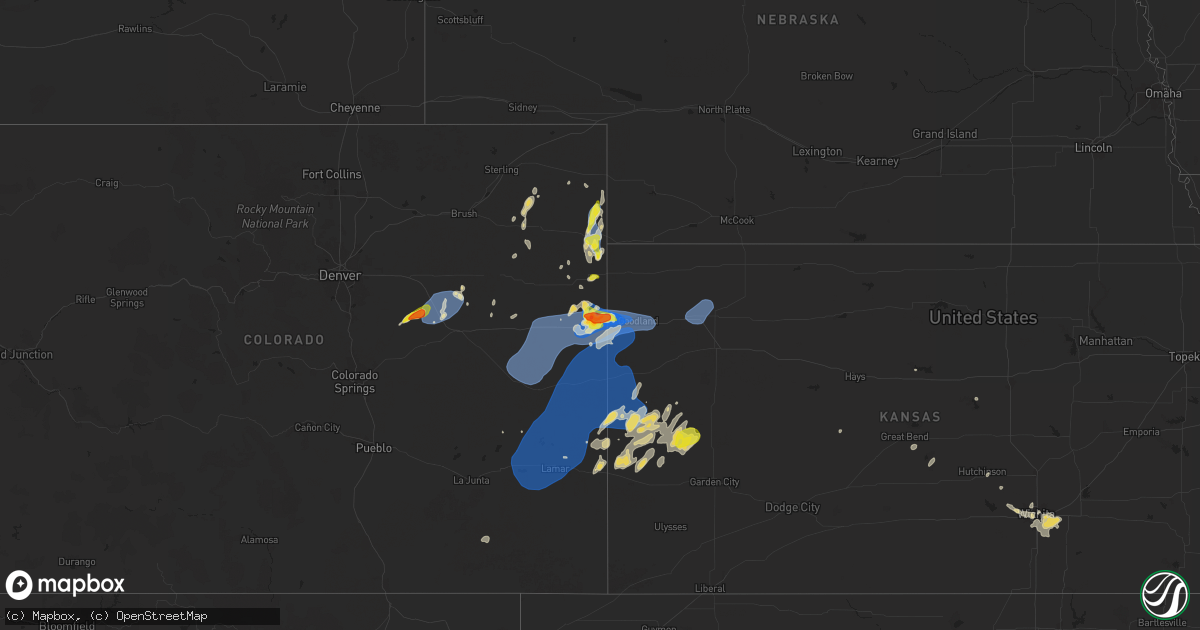
Hail Map on August 22, 2024
Get this storm
August 22 map
$229
one time, instant access
Download today. No call, no setup
Keep the $229
Bought the map and want the full workflow? Apply the entire $229 to a subscription within 7 days. None of it is wasted.
Every map, not just this one
This buys you this map. Subscription and you get every map we run, in the markets you choose from a few cities to whole states to nationwide. Plus real-time alerts the moment a storm fires.
Contact data
Name, contact info, occupancy, even credit band for addresses in the footprint. You go from where it hit to who to call.
Become the source they trust
Unlimited branding weather history reports on demand. You already have the documented answer ready for the property owner, and you are the one who showed up with it.
Property data and RoofTrace estimates
Pull up any address you have got, its value and the exact code rules for that jurisdiction, straight from One Click Code. Then RoofTrace estimates the squares, pitch, and roof value, priced the way you price.
States Impacted by Hail Map on August 22, 2024
Storm reports
Montana
| Date | Description |
|---|---|
| 08/22/20244:12 AM CDT | Asos station kdln dillon airport. |
| 08/22/20243:00 AM CDT | Ambient weather sensor. |
| 08/22/20241:59 AM CDT | Mesonet station lmrm8 antelope raws. Time is estimated given the station reports a max gust once per hour. |
Idaho
| Date | Description |
|---|---|
| 08/22/20241:50 AM CDT | Mesonet station pc219 galbraith. |
| 08/21/202411:25 PM CDT | Mesonet station rwm inl radioactive waste mgmt. |
| 08/21/202410:45 PM CDT | Mesonet station big coxs well. |
| 08/21/20248:45 PM CDT | Photo of large tree down on a single family home in the 6000 w area southwest of rexburg with significant damage to the structure. Time provided by spotter. |
Florida
| Date | Description |
|---|---|
| 08/22/20245:35 PM CDT | County dispatch reported a tree was blown down onto a home along se 41st street in belleview. The time of damage was based on radar. |
| 08/22/20245:30 PM CDT | A power pole was blown down onto a vehicle along south pine avenue with one person inside. The person inside was electrically shocked... But medical transport was not n |
| 08/22/20245:05 PM CDT | Trees were blown down into power lines along se 38th street. The time of damage was based on radar. |
| 08/22/20244:55 PM CDT | County dispatch reported a tree was blown down across a vehicle at the glade winds apartment complex with people in the vehicle. There were no injuries reported. The ti |
| 08/22/20244:53 PM CDT | County dispatch reported trees were blown down onto powerlines along sw 6th street. The time of damage was based on radar. |
| 08/22/20244:50 PM CDT | A tree fell on a rv at holiday travel park near ocala. Residence was deemed uninhabitable. No injuries were reported. An unknown number of residents were displaced. |
Colorado
| Date | Description |
|---|---|
| 08/22/20246:53 PM CDT | Mesonet station co066 cedar point. |
| 08/22/20246:50 PM CDT | Ongoing half dollar to golf ball hail that has fallen over a duration so far of 10 minutes. Skylight was broken and winds were strong... But was unable to provide an es |
| 08/22/20246:41 PM CDT | Mesonet station up693 agate. |
| 08/21/20249:05 PM CDT | City of burlington facebook page reports the entire city of burlington is without power and that it is a tri state issue. |
| 08/21/20248:17 PM CDT | Weatherunderground site kcowray7. |
| 08/21/20248:12 PM CDT | Quarter to half doolar hail for a solid two minutes. |
| 08/21/20248:00 PM CDT | Corrects previous tstm wnd gst report from 3 nnw vernon. Weatherunderground site kcowray7. |
| 08/21/20248:00 PM CDT | A local report indicates 75 MPH wind near 4 S Burlington |
| 08/21/20248:00 PM CDT | Reported via weather underground station kcocheye2. |
| 08/21/20248:00 PM CDT | Report of a 1.5 inch diameter locust tree branch down. Time radar estimated. |
| 08/21/20247:54 PM CDT | Reported via weather underground station kcocheye8. |
| 08/21/20247:47 PM CDT | Ongoing pea to quarter sized hail over a duration of 10 minutes. |
| 08/21/20247:27 PM CDT | Pea to quarter sized hail observed. Time estimated by radar and report. |
| 08/21/20247:24 PM CDT | Weatherlink site ocean front reported 42 mph sustained wind along with 59 mph gust. |
| 08/21/20247:20 PM CDT | Reports of large trees and fence posts downed in willow creek park in lamar. |
| 08/21/20247:20 PM CDT | Public gave a conservative estimate of 70 mph winds with trees being bent over on the property. |
| 08/21/20247:00 PM CDT | Asos station klaa lamar airport. |
New Mexico
| Date | Description |
|---|---|
| 08/22/20244:30 PM CDT | Asos station krow roswell air center. |
Arizona
| Date | Description |
|---|---|
| 08/22/20246:59 PM CDT | ***delayed report*** a tree snapped and fell onto indian school rd... Blocking one of the lanes. |
| 08/22/20246:58 PM CDT | ***delayed report*** power lines down in the area. |
| 08/22/20246:57 PM CDT | ***delayed report*** very large tree was uprooted and fell onto a home... Causing damage to the roof. |
| 08/22/20246:57 PM CDT | ***delayed report*** several uprooted trees along 52nd st... Near thomas rd... Including one tree falling on a vehicle at arcadia montessori. |
| 08/22/20246:55 PM CDT | ***delayed report*** power lines down in the area. |
| 08/22/20246:30 PM CDT | Microburst wind gust observed by the phx asos. |
| 08/22/20246:26 PM CDT | ***delayed report*** power lines down in the area. |
| 08/22/20246:24 PM CDT | ***delayed report*** power lines down in the area. |
| 08/22/20245:50 PM CDT | ***delayed report*** adot reported power lines down on sr-287... Between main st and valley farms rd... Leading to a closure of the highway. |
| 08/21/20247:53 PM CDT | ***delayed report*** report of trees down near shea blvd and l-101. |
| 08/21/20247:07 PM CDT | ***delayed report*** multiple large trees uprooted and/or snapped in the area of warner rd and 48th st. |
| 08/21/20247:05 PM CDT | ***delayed report*** numerous downed trees in the area... Including a few palo verdes onto vehicles and one uprooted tree that crashed through a concrete brick wall and |
Utah
| Date | Description |
|---|---|
| 08/22/20244:50 PM CDT | Mesonet station utshr sr-7 at mp 19.5 sand hollow. |
Kansas
| Date | Description |
|---|---|
| 08/21/20249:55 PM CDT | Awos station kcbk 2 n colby. |
| 08/21/20248:40 PM CDT | Estimated wind gusts at 60-65 mph... Maybe some gusts up to 70 mph. Report received |
| 08/21/20248:33 PM CDT | Delayed report of one power pole broken... But power lines were still up. |
Cities Impacted by Hail Map on August 22, 2024
- Andale, KS
- Colwich, KS
- Woodworth, ND
- Wichita, KS
- Goddard, KS
- Brookville, KS
- Britton, SD
- Havana, ND
- Forman, ND
- Bruce, SD
- Big Stone City, SD
- Bellingham, MN
- Odessa, MN
- Correll, MN
- Corona, SD
- Ortonville, MN
- Barrett, MN
- Lake Benton, MN
- Minneota, MN
- Canby, MN
- Appleton, MN
- Danvers, MN
- Tyler, MN
- Benson, MN
- Boyd, MN
- Miami, FL
- Climax, MN
- Crookston, MN
- Vail, AZ
- Santa Rosa Beach, FL
- Supai, AZ
- Green Cove Springs, FL
- Sahuarita, AZ
- Flagstaff, AZ
- Elgin, AZ
- North Rim, AZ
- Willcox, AZ
- Kearny, AZ
- Panama City, FL
- Hayden, AZ
- Winkelman, AZ
- Tucson, AZ
- Dexter, NM
- Roswell, NM
- Miami, AZ
- Tombstone, AZ
- Ocala, FL
- Belleview, FL
- Tonto Basin, AZ
- Kiowa, CO
- Florence, AZ
- Kim, CO
- Ramah, CO
- Arimo, ID
- Agate, CO
- Bethune, CO
- Burlington, CO
- Deer Trail, CO
- Hereford, AZ
- Stratton, CO
- Mccammon, ID
- Patagonia, AZ
- Phoenix, AZ
- Scottsdale, AZ
- Paradise Valley, AZ
- Arriba, CO
- Flagler, CO
- Limon, CO
- Payson, AZ
- Idalia, CO
- Kanorado, KS
- Wray, CO
- Woodrow, CO
- McClave, CO
- Hasty, CO
- Las Animas, CO
- Lamar, CO
- Holly, CO
- Eads, CO
- Wiley, CO
- Sheridan Lake, CO
- Kit Carson, CO
- Hugo, CO
- Vona, CO
- Seibert, CO
- Cheyenne Wells, CO
- Arapahoe, CO
- Weskan, KS
- Leupp, AZ
- Goodland, KS
- Sharon Springs, KS
- Tribune, KS
- Vernon, CO
- Green Valley, AZ
- Yuma, CO
- Roosevelt, AZ
- Kirk, CO
- Akron, CO
- Edson, KS
- Otis, CO
- Syracuse, KS
- Leoti, KS
- Fleming, CO
- Lakin, KS
- Deerfield, KS
- Holyoke, CO
- Marienthal, KS
- Levant, KS
- Colby, KS
- Gem, KS
- Moore, ID
- Howe, ID
- Arco, ID
- Carey, ID
- Blackfoot, ID
- Atomic City, ID
- Alexander, KS
- Hudson, KS
- St John, KS
- Great Bend, KS
- Ellinwood, KS
- Dillon, MT
- Lima, MT
- Dell, MT
- Polaris, MT
- Virginia City, MT
- Twin Bridges, MT
- Sheridan, MT
- Glen, MT
- Sylvia, KS
- Hutchinson, KS
- Haven, KS
- Burrton, KS
- Derby, KS
- Haysville, KS
- Mulvane, KS
- Mcconnell Afb, KS
- Rose Hill, KS
- Andover, KS
- Augusta, KS