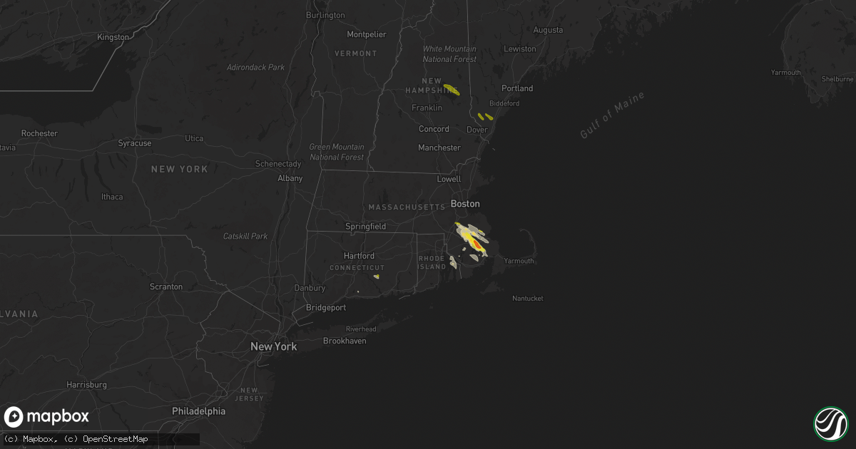
Hail Map in Massachusetts on August 22, 2020
Get this storm
August 22 map
$229
one time, instant access
Download today. No call, no setup
Keep the $229
Bought the map and want the full workflow? Apply the entire $229 to a subscription within 7 days. None of it is wasted.
Every map, not just this one
This buys you this map. Subscription and you get every map we run, in the markets you choose from a few cities to whole states to nationwide. Plus real-time alerts the moment a storm fires.
Contact data
Name, contact info, occupancy, even credit band for addresses in the footprint. You go from where it hit to who to call.
Become the source they trust
Unlimited branding weather history reports on demand. You already have the documented answer ready for the property owner, and you are the one who showed up with it.
Property data and RoofTrace estimates
Pull up any address you have got, its value and the exact code rules for that jurisdiction, straight from One Click Code. Then RoofTrace estimates the squares, pitch, and roof value, priced the way you price.
Storm reports in Massachusetts
Massachusetts
| Date | Description |
|---|---|
| 08/22/20204:35 PM CDT | Wires down on acushnet ave at ashley boulevard |
| 08/22/20204:30 PM CDT | Multiple trees down at joint base cape cod |
| 08/22/20203:43 PM CDT | Tree down on main st |
| 08/22/20203:30 PM CDT | Large tree down on wires on wareham st at margery st |
| 08/22/20203:30 PM CDT | Large tree down on colonial post drive |
| 08/22/20203:25 PM CDT | 1 mile from chestnut st |
| 08/22/20203:19 PM CDT | A local report indicates 1.00 inch wind near MIDDLEBOROUGH |
| 08/22/20203:19 PM CDT | Tree down blocking road on bond st at main st |
| 08/22/20203:13 PM CDT | Trees and wires down blocking road on union st from pleasant st to mount pleasant st |
| 08/22/20203:10 PM CDT | A local report indicates 1.00 inch wind near MIDDLEBOROUGH |
| 08/22/20203:02 PM CDT | Trees and wires down on a car on south elm at scotland st |
| 08/22/20201:49 PM CDT | Tree down on essex st at plymouth st |
| 08/22/20201:40 PM CDT | Tree down on pearl st |
| 08/22/202012:22 PM CDT | Wires down on spear ave |
| 08/22/202012:06 PM CDT | Tree down on fairview ave at torrey street. |
| 08/22/202011:40 AM CDT | Tree down on north st |
| 08/22/202011:25 AM CDT | Tree down on north st |
| 08/22/202011:22 AM CDT | Tree down on wires at 146 north street. |
| 08/22/20209:42 AM CDT | Large tree down at river and elm street. |
| 08/22/20209:38 AM CDT | Utility pole and lines down on spaulding street. |
| 08/22/20207:50 AM CDT | At 1249 PM EDT, a severe thunderstorm was located over Brockton, moving southeast at 30 mph. HAZARD...Ping pong ball size hail and 60 mph wind gusts. SOURCE...Radar indicated. IMPACT...Expect wind damage to trees and power lines. Minor hail damage to vehicles is possible. Locations impacted include... Brockton, Quincy, Plymouth, Weymouth, Braintree, Randolph, Milton, Stoughton, Bridgewater, Marshfield, Mansfield, Middleborough, Easton, Hingham, Wareham, Canton, Pembroke, Sharon, Rockland and Foxborough. |
| 08/22/20207:15 AM CDT | At 1215 PM EDT, a severe thunderstorm was located over Medfield, or near Norwood, moving southeast at 35 mph. HAZARD...60 mph wind gusts and quarter size hail. SOURCE...Radar indicated. IMPACT...Expect wind damage to trees and power lines. Minor hail damage to vehicles is possible. Locations impacted include... Brockton, Weymouth, Braintree, Natick, Randolph, Norwood, Stoughton, Bridgewater, Marshfield, Dedham, Walpole, Middleborough, Easton, Canton, Pembroke, Sharon, Rockland, Foxborough, Abington and Duxbury. |
| 08/22/202012:16 AM CDT | At 515 PM EDT, a severe thunderstorm was located near Falmouth, moving southeast at 30 mph. HAZARD...60 mph wind gusts and quarter size hail. SOURCE...Radar indicated. IMPACT...Expect wind damage to trees and power lines. Minor hail damage to vehicles is possible. Locations impacted include... Barnstable, Falmouth, Sandwich, Bourne and Mashpee. |
| 08/22/202012:09 AM CDT | At 509 PM EDT, a severe thunderstorm was located over Warwick, moving southeast at 30 mph. HAZARD...60 mph wind gusts and quarter size hail. SOURCE...Radar indicated. IMPACT...Expect wind damage to trees and power lines. Minor hail damage to vehicles is possible. Locations impacted include... Providence, New Bedford, Fall River, Warwick, Cranston, East Providence, Coventry, Dartmouth, West Warwick, Johnston, North Kingstown, Bristol, Somerset, Portsmouth, Barrington, Swansea, Tiverton, Westport, East Greenwich and Warren. |
| 08/21/202011:30 PM CDT | At 429 PM EDT, a severe thunderstorm was located near Carver, or 9 miles north of Marion, moving southeast at 20 mph. HAZARD...60 mph wind gusts and half dollar size hail. SOURCE...Radar indicated. This storm has a history of widespread wind damage in the Bridgewater and Lakevill areas. IMPACT...Expect wind damage to trees and power lines. Minor hail damage to vehicles is possible. Locations impacted include... New Bedford, Plymouth, Barnstable, Falmouth, Marion, Middleborough, Wareham, Sandwich, Bourne, Mashpee, Kingston, Carver, Lakeville, Acushnet, Freetown, Mattapoisett, Rochester and Plympton. |
| 08/21/202010:50 PM CDT | At 350 PM EDT, a severe thunderstorm was located over West Bridgewater, or near Bridgewater, moving southeast at 20 mph. HAZARD...60 mph wind gusts and quarter size hail. SOURCE...Radar indicated. IMPACT...Expect wind damage to trees and power lines. Minor hail damage to vehicles is possible. Locations impacted include... Brockton, Plymouth, Taunton, Stoughton, Bridgewater, Middleborough, Easton, Wareham, Norton, Pembroke, Rockland, Abington, Duxbury, Whitman, East Bridgewater, Raynham, Kingston, Carver, Holbrook and Lakeville. |
| 08/21/202010:14 PM CDT | At 314 PM EDT, a severe thunderstorm was located over Walpole, or near Norwood, moving southeast at 20 mph. HAZARD...60 mph wind gusts and quarter size hail. SOURCE...Radar indicated. IMPACT...Expect wind damage to trees and power lines. Minor hail damage to vehicles is possible. Locations impacted include... Brockton, Quincy, Weymouth, Braintree, Randolph, Franklin, Norwood, Milton, Stoughton, Bridgewater, Dedham, Walpole, Mansfield, Easton, Hingham, Canton, Sharon, Rockland, Foxborough and Abington. |
| 08/21/20209:42 PM CDT | At 242 PM EDT, a severe thunderstorm was located over Whitman, or near Brockton, moving southeast at 20 mph. HAZARD...60 mph wind gusts and quarter size hail. SOURCE...Radar indicated. IMPACT...Expect wind damage to trees and power lines. Minor hail damage to vehicles is possible. Locations impacted include... Brockton, Plymouth, Weymouth, Marshfield, Hingham, Scituate, Pembroke, Rockland, Abington, Duxbury, Whitman, Hanover, East Bridgewater, Kingston, Norwell, Hanson, Halifax, West Bridgewater and Plympton. |
| 08/21/20209:03 PM CDT | At 203 PM EDT, a severe thunderstorm was located over Canton, or near Stoughton, moving southeast at 20 mph. HAZARD...60 mph wind gusts and quarter size hail. SOURCE...Radar indicated. IMPACT...Expect wind damage to trees and power lines. Minor hail damage to vehicles is possible. Locations impacted include... Brockton, Quincy, Weymouth, Braintree, Randolph, Norwood, Milton, Stoughton, Dedham, Walpole, Easton, Hingham, Canton, Sharon, Rockland, Abington, Westwood, Whitman, Hanover and East Bridgewater. |
| 08/21/20208:39 PM CDT | At 139 PM EDT, a severe thunderstorm was located over Chatham, moving southeast at 20 mph. HAZARD...60 mph wind gusts and quarter size hail. SOURCE...Radar indicated. IMPACT...Hail damage to vehicles is expected. Expect wind damage to roofs, siding, and trees. This severe thunderstorm will be near... Philmont around 145 PM EDT. Austerlitz around 200 PM EDT. Housatonic around 225 PM EDT.Other locations impacted by this severe thunderstorm includeRisingdale, West Stockbridge Center, Hillsdale, Omi, Alford,Mellenville, Craryville, Rossman, Glendale and Red Rock. |
| 08/21/20208:28 PM CDT | At 127 PM EDT, a severe thunderstorm was located over Halifax, or 7 miles east of Bridgewater, moving southeast at 20 mph. HAZARD...60 mph wind gusts and quarter size hail. SOURCE...Radar indicated. IMPACT...Expect wind damage to trees and power lines. Minor hail damage to vehicles is possible. Locations impacted include... Plymouth, Bridgewater, Middleborough, Wareham, Pembroke, Rockland, Duxbury, Whitman, Hanover, East Bridgewater, Kingston, Carver, Hanson, Halifax, West Bridgewater and Plympton. |
All States Impacted by Hail Map on August 22, 2020
Cities Impacted by Hail Map on August 22, 2020
- De Witt, IA
- Flagstaff, AZ
- Baldwin, IA
- Fall River, MA
- Bristol, RI
- Warren, RI
- Portsmouth, RI
- Swansea, MA
- Tiverton, RI
- Emily, MN
- Palisade, MN
- Kiron, IA
- Odebolt, IA
- Campo, CA
- Pine Valley, CA
- Bridgewater, MA
- West Wareham, MA
- South Easton, MA
- Sharon, MA
- North Easton, MA
- Stoughton, MA
- Lakeville, MA
- West Bridgewater, MA
- Halifax, MA
- Carver, MA
- Raynham, MA
- Middleboro, MA
- Brockton, MA
- East Bridgewater, MA
- Prescott, AZ
- Nipton, CA
- Nashwauk, MN
- Willcox, AZ
- Crosby, MN
- Wolfeboro, NH
- Mirror Lake, NH
- Preston, IA
- Charlotte, IA
- Guilford, CT
- Garrison, MN
- Saint Cloud, MN
- Kendalia, TX
- Mansfield, MA
- East Taunton, MA
- Rochester, MA
- Norton, MA
- Hillman, MN
- Young, AZ
- Mayer, AZ
- East Haddam, CT
- Moodus, CT
- Elfrida, AZ
- Hibbing, MN
- Early, IA
- Schaller, IA
- Roosevelt, AZ
- Sandstone, MN
- Chisholm, MN
- Hackberry, AZ
- Freeport, MN
- Holdingford, MN
- Albany, MN
- Swanville, MN
- Upsala, MN
- Burtrum, MN
- Bowlus, MN
- Grey Eagle, MN
- Fort Ripley, MN
- Brainerd, MN
- Vail, IA
- Fonda, IA
- Pomeroy, IA
- Plympton, MA
- Williams, AZ
- Aitkin, MN
- New Hartford, IA
- Shell Rock, IA
- Galva, IA
- Coleman, TX
- Holy Cross, IA
- Sherrill, IA
- Pittsburgh, PA
- Sedona, AZ
- Pearce, AZ
- Side Lake, MN
- Spragueville, IA
- Maquoketa, IA
- Elgin, AZ
- Muscatine, IA
- Cushing, MN
- Seligman, AZ
- Somerset, MA
- Dewey, AZ
- Colchester, CT
- East Hampton, CT
- Quimby, IA
- Cherokee, IA
- Benson, AZ
- Berkley, MA
- Clarksville, IA
- Burkett, TX
- Cross Plains, TX
- Pima, AZ
- Thatcher, AZ
- Parkersburg, IA
- Pengilly, MN
- Goodland, MN
- Sweeny, TX
- Buckhorn, NM
- Deerwood, MN
- Onamia, MN
- San Simon, AZ
- Cook, MN
- Mount Sterling, KY
- Peach Springs, AZ
- Crosslake, MN
- Cave Creek, AZ
- Monmouth, IA
- Onslow, IA
- Richville, MN
- Lost Nation, IA
- Oxford Junction, IA
- Chino Valley, AZ
- Whitman, MA
- Wareham, MA
- Abington, MA
- Plymouth, MA
- Hanson, MA
- Kingston, MA
- Marion, MA
- Pembroke, MA
- Ida Grove, IA
- Arthur, IA
- Atalissa, IA
- Moscow, IA
- Bay City, TX
- New Bedford, MA
- Mattapoisett, MA
- Acushnet, MA
- East Freetown, MA
- Allen, NE
- Fifty Lakes, MN
- Boerne, TX
- Waverly, IA
- Janesville, IA
- Clyde, TX
- Garner, IA
- Klemme, IA
- League City, TX
- Handley, WV
- Underwood, MN
- Pocahontas, IA
- Palmer, IA
- Santa Anna, TX
- Royalton, MN
- Outing, MN
- Ottertail, MN
- Durango, IA
- French Creek, WV
- Baird, TX
- Animas, NM
- Manson, IA
- Littlefield, AZ
- Sugar Grove, OH
- Lancaster, OH
- Grand Rapids, MN
- Foley, MN
- Wells, ME
- Sanford, ME
- North Berwick, ME
- Berwick, ME
- Center Tuftonboro, NH
- Moultonborough, NH
- Chatham, NY
- Ghent, NY
- Sauk Rapids, MN
- Rice, MN


