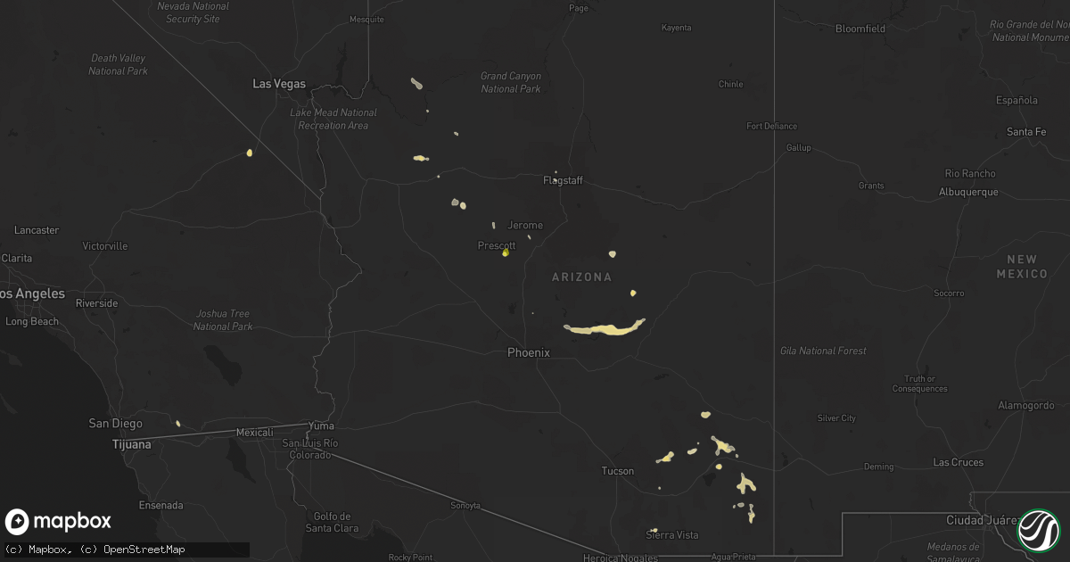
Hail Map in Arizona on August 22, 2020
Get this storm
August 22 map
$229
one time, instant access
Download today. No call, no setup
Keep the $229
Bought the map and want the full workflow? Apply the entire $229 to a subscription within 7 days. None of it is wasted.
Every map, not just this one
This buys you this map. Subscription and you get every map we run, in the markets you choose from a few cities to whole states to nationwide. Plus real-time alerts the moment a storm fires.
Contact data
Name, contact info, occupancy, even credit band for addresses in the footprint. You go from where it hit to who to call.
Become the source they trust
Unlimited branding weather history reports on demand. You already have the documented answer ready for the property owner, and you are the one who showed up with it.
Property data and RoofTrace estimates
Pull up any address you have got, its value and the exact code rules for that jurisdiction, straight from One Click Code. Then RoofTrace estimates the squares, pitch, and roof value, priced the way you price.
Storm reports in Arizona
Arizona
| Date | Description |
|---|---|
| 08/22/20206:40 PM CDT | Trained spotter reports one inch hail. |
| 08/22/20205:00 PM CDT | From facebook... A photo of estimated 1 inch hail stones in the persons hand. |
| 08/22/20204:14 AM CDT | At 914 PM MST, a severe thunderstorm was located 18 miles northeast of Saguaro National Park East, or 27 miles southeast of Oracle, moving west at 10 mph. HAZARD...60 mph wind gusts and quarter size hail. SOURCE...Radar indicated. IMPACT...Hail damage to vehicles is expected. Expect wind damage to roofs, siding, and trees. Locations impacted include... Saguaro National Park East and Cascabel. |
| 08/22/20202:51 AM CDT | At 751 PM MST, a severe thunderstorm was located over Four Peaks, or 10 miles west of Roosevelt, moving west at 30 mph. HAZARD...60 mph wind gusts and half dollar size hail. SOURCE...Radar indicated. IMPACT...Hail damage to vehicles is expected. Expect wind damage to roofs, siding, and trees. Locations impacted include... Sugarloaf Mountain, Ballantine Trailhead, Roosevelt, Roosevelt Dam, Lost Dutchman State Park, Goldfield, Saguaro Lake, Canyon Lake, Superstition Mountains, Tonto National Monument, Goldfield Ranch, Four Peaks, Apache Lake, Salt River Tubing Recreation Area and Rio Verde. |
| 08/22/20202:01 AM CDT | At 700 PM MST, a severe thunderstorm was located 19 miles west of Paulden, or 22 miles northwest of Chino Valley, moving southeast at 5 mph. HAZARD...70 mph wind gusts and quarter size hail. SOURCE...Radar indicated. IMPACT...Hail damage to vehicles is expected. Expect considerable tree damage. Wind damage is also likely to mobile homes, roofs, and outbuildings. Locations impacted include... Walnut Creek Ranger Station. |
| 08/22/20202:00 AM CDT | At 659 PM MST, a severe thunderstorm was located over Tonto National Monument, or near Roosevelt, moving west at 30 mph. HAZARD...60 mph wind gusts and half dollar size hail. SOURCE...Radar indicated. IMPACT...Hail damage to vehicles is expected. Expect wind damage to roofs, siding, and trees. Locations impacted include... Roosevelt, Tonto National Monument, Four Peaks, Roosevelt Dam, Apache Lake, Tonto Basin and Roosevelt Estates. |
| 08/22/20201:46 AM CDT | At 644 PM MST, a severe thunderstorm was located 11 miles northeast of Willcox, moving south at 15 mph. HAZARD...60 mph wind gusts and half dollar size hail. SOURCE...Radar indicated. IMPACT...Hail damage to vehicles is expected. Expect wind damage to roofs, siding, and trees. Locations impacted include... Willcox and Bowie. This includes the following highways... Interstate 10 between mile markers 337 and 366. Route 186 between mile markers 327 and 346. Route 191 between mile markers 88 and 99. |
| 08/22/20201:42 AM CDT | At 642 PM MST, a severe thunderstorm was located 11 miles east of Tonto National Monument, or 13 miles east of Roosevelt, moving southwest at 20 mph. HAZARD...60 mph wind gusts and quarter size hail. SOURCE...Radar indicated. IMPACT...Hail damage to vehicles is expected. Expect wind damage to roofs, siding, and trees. Locations impacted include... Roosevelt Estates. |
| 08/22/20201:21 AM CDT | At 621 PM MST, a severe thunderstorm was located 8 miles west of Thatcher, or 11 miles west of Safford, moving southwest at 15 mph. HAZARD...60 mph wind gusts and quarter size hail. SOURCE...Radar indicated. IMPACT...Hail damage to vehicles is expected. Expect wind damage to roofs, siding, and trees. Locations impacted include... Safford, Thatcher, Roper Lake State Park, Pima, Central, Swift Trail Junction, Fort Grant, Mount Graham, Bonita and Frye Mesa Dam.This includes the following highways... Route 70 between mile markers 314 and 342. Route 191 between mile markers 104 and 120. Route 266 between mile markers 105 and 126. |
| 08/22/20201:13 AM CDT | At 612 PM MST, a severe thunderstorm was located 22 miles west of Paulden, or 26 miles northwest of Chino Valley, moving southeast at 5 mph. HAZARD...60 mph wind gusts and quarter size hail. SOURCE...Radar indicated. IMPACT...Hail damage to vehicles is expected. Expect wind damage to roofs, siding, and trees. Locations impacted include... Walnut Creek Ranger Station. |
| 08/22/202012:55 AM CDT | At 554 PM MST, a severe thunderstorm was located near San Carlos, or 21 miles east of Globe, moving southwest at 20 mph. HAZARD...60 mph wind gusts and quarter size hail. SOURCE...Radar indicated. IMPACT...Hail damage to vehicles is expected. Expect wind damage to roofs, siding, and trees. Locations impacted include... San Carlos Reservoir.This includes Route 70 between mile markers 272 and 280. |
| 08/22/202012:46 AM CDT | At 546 PM MST, a severe thunderstorm was located 13 miles northwest of Bowie, or 17 miles northeast of Willcox, moving southwest at 10 mph. HAZARD...60 mph wind gusts and quarter size hail. SOURCE...Radar indicated. IMPACT...Hail damage to vehicles is expected. Expect wind damage to roofs, siding, and trees. This severe thunderstorm will remain over mainly remote areas of south central Graham and north central Cochise Counties.This includes the following highways... Interstate 10 between mile markers 349 and 360. Route 191 between mile markers 88 and 99. |
| 08/22/202012:37 AM CDT | At 537 PM MST, a severe thunderstorm was located near San Carlos, or 21 miles east of Globe, moving southwest at 30 mph. HAZARD...60 mph wind gusts and half dollar size hail. SOURCE...Radar indicated. IMPACT...Hail damage to vehicles is expected. Expect wind damage to roofs, siding, and trees. Locations impacted include... San Carlos and Cutter. |
| 08/22/202012:16 AM CDT | At 515 PM MST, a severe thunderstorm was located near Fraziers Well, or 60 miles northeast of Kingman, and is nearly stationary. HAZARD...60 mph wind gusts and quarter size hail. SOURCE...Radar indicated. IMPACT...Hail damage to vehicles is expected. Expect wind damage to roofs, siding, and trees. Locations impacted include... Hualapai Reservation. |
| 08/21/202011:40 PM CDT | At 440 PM MST, a severe thunderstorm was located 15 miles southeast of Young, or 23 miles south of Forest Lakes, and is nearly stationary. HAZARD...60 mph wind gusts and half dollar size hail. SOURCE...Radar indicated. IMPACT...Hail damage to vehicles is expected. Expect wind damage to roofs, siding, and trees. This severe thunderstorm will remain over mainly rural areas of Gila and Navajo Counties. |
| 08/21/202011:21 PM CDT | At 421 PM MST, a severe thunderstorm was located over Walker, or 7 miles south of Prescott Valley, and is nearly stationary. HAZARD...60 mph wind gusts and half dollar size hail. SOURCE...Radar indicated. IMPACT...Hail damage to vehicles is expected. Expect wind damage to roofs, siding, and trees. Locations impacted include... Prescott Valley, Walker and Lynx Lake Dam. |
| 08/21/202011:09 PM CDT | At 409 PM MST, a severe thunderstorm was located 9 miles east of Young, or 18 miles south of Forest Lakes, and is nearly stationary. HAZARD...60 mph wind gusts and half dollar size hail. SOURCE...Radar indicated. IMPACT...Hail damage to vehicles is expected. Expect wind damage to roofs, siding, and trees. This severe thunderstorm will remain over mainly rural areas of Gila County. |
| 08/21/202010:01 PM CDT | At 300 PM MST, a severe thunderstorm was located 24 miles south of Seligman, or 32 miles northwest of Chino Valley, and is nearly stationary. HAZARD...60 mph wind gusts and quarter size hail. SOURCE...Radar indicated. IMPACT...Hail damage to vehicles is expected. Expect wind damage to roofs, siding, and trees. This severe thunderstorm will remain over mainly rural areas of Yavapai County. |
| 08/21/20208:55 PM CDT | At 154 PM MST, a severe thunderstorm was located 10 miles east of Laguna Lake, moving northwest at 5 mph. HAZARD...60 mph wind gusts and quarter size hail. SOURCE...Radar indicated. IMPACT...Hail damage to vehicles is expected. Expect wind damage to roofs, siding, and trees. Locations impacted include... Laguna Lake and Hualapai Reservation. |
| 08/21/20208:10 PM CDT | Window broken by fallen pole. Power out in town. Two 30-ft travel trailers flipped. Time estimated. |
All States Impacted by Hail Map on August 22, 2020
Cities Impacted by Hail Map on August 22, 2020
- De Witt, IA
- Flagstaff, AZ
- Baldwin, IA
- Fall River, MA
- Bristol, RI
- Warren, RI
- Portsmouth, RI
- Swansea, MA
- Tiverton, RI
- Emily, MN
- Palisade, MN
- Kiron, IA
- Odebolt, IA
- Campo, CA
- Pine Valley, CA
- Bridgewater, MA
- West Wareham, MA
- South Easton, MA
- Sharon, MA
- North Easton, MA
- Stoughton, MA
- Lakeville, MA
- West Bridgewater, MA
- Halifax, MA
- Carver, MA
- Raynham, MA
- Middleboro, MA
- Brockton, MA
- East Bridgewater, MA
- Prescott, AZ
- Nipton, CA
- Nashwauk, MN
- Willcox, AZ
- Crosby, MN
- Wolfeboro, NH
- Mirror Lake, NH
- Preston, IA
- Charlotte, IA
- Guilford, CT
- Garrison, MN
- Saint Cloud, MN
- Kendalia, TX
- Mansfield, MA
- East Taunton, MA
- Rochester, MA
- Norton, MA
- Hillman, MN
- Young, AZ
- Mayer, AZ
- East Haddam, CT
- Moodus, CT
- Elfrida, AZ
- Hibbing, MN
- Early, IA
- Schaller, IA
- Roosevelt, AZ
- Sandstone, MN
- Chisholm, MN
- Hackberry, AZ
- Freeport, MN
- Holdingford, MN
- Albany, MN
- Swanville, MN
- Upsala, MN
- Burtrum, MN
- Bowlus, MN
- Grey Eagle, MN
- Fort Ripley, MN
- Brainerd, MN
- Vail, IA
- Fonda, IA
- Pomeroy, IA
- Plympton, MA
- Williams, AZ
- Aitkin, MN
- New Hartford, IA
- Shell Rock, IA
- Galva, IA
- Coleman, TX
- Holy Cross, IA
- Sherrill, IA
- Pittsburgh, PA
- Sedona, AZ
- Pearce, AZ
- Side Lake, MN
- Spragueville, IA
- Maquoketa, IA
- Elgin, AZ
- Muscatine, IA
- Cushing, MN
- Seligman, AZ
- Somerset, MA
- Dewey, AZ
- Colchester, CT
- East Hampton, CT
- Quimby, IA
- Cherokee, IA
- Benson, AZ
- Berkley, MA
- Clarksville, IA
- Burkett, TX
- Cross Plains, TX
- Pima, AZ
- Thatcher, AZ
- Parkersburg, IA
- Pengilly, MN
- Goodland, MN
- Sweeny, TX
- Buckhorn, NM
- Deerwood, MN
- Onamia, MN
- San Simon, AZ
- Cook, MN
- Mount Sterling, KY
- Peach Springs, AZ
- Crosslake, MN
- Cave Creek, AZ
- Monmouth, IA
- Onslow, IA
- Richville, MN
- Lost Nation, IA
- Oxford Junction, IA
- Chino Valley, AZ
- Whitman, MA
- Wareham, MA
- Abington, MA
- Plymouth, MA
- Hanson, MA
- Kingston, MA
- Marion, MA
- Pembroke, MA
- Ida Grove, IA
- Arthur, IA
- Atalissa, IA
- Moscow, IA
- Bay City, TX
- New Bedford, MA
- Mattapoisett, MA
- Acushnet, MA
- East Freetown, MA
- Allen, NE
- Fifty Lakes, MN
- Boerne, TX
- Waverly, IA
- Janesville, IA
- Clyde, TX
- Garner, IA
- Klemme, IA
- League City, TX
- Handley, WV
- Underwood, MN
- Pocahontas, IA
- Palmer, IA
- Santa Anna, TX
- Royalton, MN
- Outing, MN
- Ottertail, MN
- Durango, IA
- French Creek, WV
- Baird, TX
- Animas, NM
- Manson, IA
- Littlefield, AZ
- Sugar Grove, OH
- Lancaster, OH
- Grand Rapids, MN
- Foley, MN
- Wells, ME
- Sanford, ME
- North Berwick, ME
- Berwick, ME
- Center Tuftonboro, NH
- Moultonborough, NH
- Chatham, NY
- Ghent, NY
- Sauk Rapids, MN
- Rice, MN


