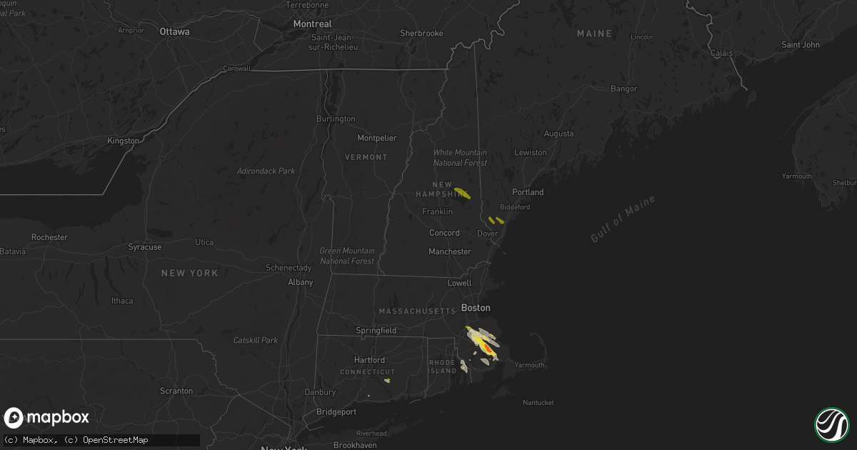
Hail Map in New Hampshire on August 22, 2020
Get this storm
August 22 map
$229
one time, instant access
Download today. No call, no setup
Keep the $229
Bought the map and want the full workflow? Apply the entire $229 to a subscription within 7 days. None of it is wasted.
Every map, not just this one
This buys you this map. Subscription and you get every map we run, in the markets you choose from a few cities to whole states to nationwide. Plus real-time alerts the moment a storm fires.
Contact data
Name, contact info, occupancy, even credit band for addresses in the footprint. You go from where it hit to who to call.
Become the source they trust
Unlimited branding weather history reports on demand. You already have the documented answer ready for the property owner, and you are the one who showed up with it.
Property data and RoofTrace estimates
Pull up any address you have got, its value and the exact code rules for that jurisdiction, straight from One Click Code. Then RoofTrace estimates the squares, pitch, and roof value, priced the way you price.
Storm reports in New Hampshire
New Hampshire
| Date | Description |
|---|---|
| 08/22/20201:05 PM CDT | Minor shingle damage to two structures. Around 15 snapped and uprooted trees. |
| 08/22/20201:00 PM CDT | Tree down across rt. 16 in center ossipee. Time estimated by radar. |
| 08/22/202011:58 AM CDT | Trees down across rt 109 at baas rd. |
| 08/22/202011:50 AM CDT | Multiple reports of trees down. |
| 08/22/202011:45 AM CDT | Corrects previous water spout report from 3 sw wolfeboro. Time estimated via radar ... Video sent via facebook. |
| 08/22/20207:23 AM CDT | At 1222 PM EDT, a severe thunderstorm was located near Moultonborough, moving southeast at 20 mph. HAZARD...60 mph wind gusts and quarter size hail. SOURCE...Radar indicated. IMPACT...Hail damage to vehicles is expected. Expect wind damage to roofs, siding, and trees. Locations impacted include... Ossipee, Moultonborough, Meredith, Alton, Wolfeboro, Gilford, Center Harber and Tuftonboro.This also includes... Lake Winnipesaukee. |
| 08/22/20205:38 AM CDT | At 1038 AM EDT, a severe thunderstorm was located over Pepperell, or 8 miles southwest of Nashua, moving east at 40 mph. HAZARD...60 mph wind gusts and quarter size hail. SOURCE...Radar indicated. IMPACT...Expect wind damage to trees and power lines. Minor hail damage to vehicles is possible. Locations impacted include... Lowell, Lawrence, Methuen, Billerica, Chelmsford, Andover, Dracut, Tewksbury, North Andover, Wilmington, Westford, Acton, Concord, Bedford, Pepperell, Tyngsborough, Groton, Lunenburg, Townsend and Littleton. |
All States Impacted by Hail Map on August 22, 2020
Cities Impacted by Hail Map on August 22, 2020
- De Witt, IA
- Flagstaff, AZ
- Baldwin, IA
- Fall River, MA
- Bristol, RI
- Warren, RI
- Portsmouth, RI
- Swansea, MA
- Tiverton, RI
- Emily, MN
- Palisade, MN
- Kiron, IA
- Odebolt, IA
- Campo, CA
- Pine Valley, CA
- Bridgewater, MA
- West Wareham, MA
- South Easton, MA
- Sharon, MA
- North Easton, MA
- Stoughton, MA
- Lakeville, MA
- West Bridgewater, MA
- Halifax, MA
- Carver, MA
- Raynham, MA
- Middleboro, MA
- Brockton, MA
- East Bridgewater, MA
- Prescott, AZ
- Nipton, CA
- Nashwauk, MN
- Willcox, AZ
- Crosby, MN
- Wolfeboro, NH
- Mirror Lake, NH
- Preston, IA
- Charlotte, IA
- Guilford, CT
- Garrison, MN
- Saint Cloud, MN
- Kendalia, TX
- Mansfield, MA
- East Taunton, MA
- Rochester, MA
- Norton, MA
- Hillman, MN
- Young, AZ
- Mayer, AZ
- East Haddam, CT
- Moodus, CT
- Elfrida, AZ
- Hibbing, MN
- Early, IA
- Schaller, IA
- Roosevelt, AZ
- Sandstone, MN
- Chisholm, MN
- Hackberry, AZ
- Freeport, MN
- Holdingford, MN
- Albany, MN
- Swanville, MN
- Upsala, MN
- Burtrum, MN
- Bowlus, MN
- Grey Eagle, MN
- Fort Ripley, MN
- Brainerd, MN
- Vail, IA
- Fonda, IA
- Pomeroy, IA
- Plympton, MA
- Williams, AZ
- Aitkin, MN
- New Hartford, IA
- Shell Rock, IA
- Galva, IA
- Coleman, TX
- Holy Cross, IA
- Sherrill, IA
- Pittsburgh, PA
- Sedona, AZ
- Pearce, AZ
- Side Lake, MN
- Spragueville, IA
- Maquoketa, IA
- Elgin, AZ
- Muscatine, IA
- Cushing, MN
- Seligman, AZ
- Somerset, MA
- Dewey, AZ
- Colchester, CT
- East Hampton, CT
- Quimby, IA
- Cherokee, IA
- Benson, AZ
- Berkley, MA
- Clarksville, IA
- Burkett, TX
- Cross Plains, TX
- Pima, AZ
- Thatcher, AZ
- Parkersburg, IA
- Pengilly, MN
- Goodland, MN
- Sweeny, TX
- Buckhorn, NM
- Deerwood, MN
- Onamia, MN
- San Simon, AZ
- Cook, MN
- Mount Sterling, KY
- Peach Springs, AZ
- Crosslake, MN
- Cave Creek, AZ
- Monmouth, IA
- Onslow, IA
- Richville, MN
- Lost Nation, IA
- Oxford Junction, IA
- Chino Valley, AZ
- Whitman, MA
- Wareham, MA
- Abington, MA
- Plymouth, MA
- Hanson, MA
- Kingston, MA
- Marion, MA
- Pembroke, MA
- Ida Grove, IA
- Arthur, IA
- Atalissa, IA
- Moscow, IA
- Bay City, TX
- New Bedford, MA
- Mattapoisett, MA
- Acushnet, MA
- East Freetown, MA
- Allen, NE
- Fifty Lakes, MN
- Boerne, TX
- Waverly, IA
- Janesville, IA
- Clyde, TX
- Garner, IA
- Klemme, IA
- League City, TX
- Handley, WV
- Underwood, MN
- Pocahontas, IA
- Palmer, IA
- Santa Anna, TX
- Royalton, MN
- Outing, MN
- Ottertail, MN
- Durango, IA
- French Creek, WV
- Baird, TX
- Animas, NM
- Manson, IA
- Littlefield, AZ
- Sugar Grove, OH
- Lancaster, OH
- Grand Rapids, MN
- Foley, MN
- Wells, ME
- Sanford, ME
- North Berwick, ME
- Berwick, ME
- Center Tuftonboro, NH
- Moultonborough, NH
- Chatham, NY
- Ghent, NY
- Sauk Rapids, MN
- Rice, MN


