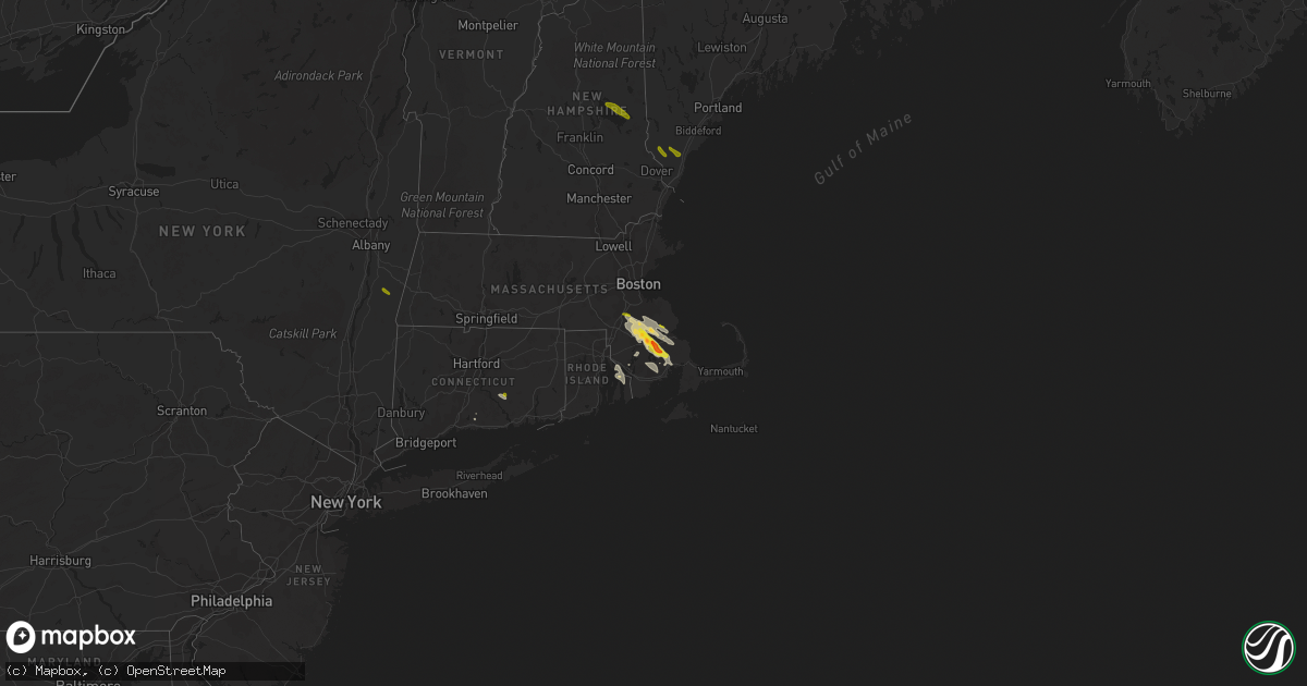
Hail Map on August 22, 2020
Get this storm
August 22 map
$229
one time, instant access
Download today. No call, no setup
Keep the $229
Bought the map and want the full workflow? Apply the entire $229 to a subscription within 7 days. None of it is wasted.
Every map, not just this one
This buys you this map. Subscription and you get every map we run, in the markets you choose from a few cities to whole states to nationwide. Plus real-time alerts the moment a storm fires.
Contact data
Name, contact info, occupancy, even credit band for addresses in the footprint. You go from where it hit to who to call.
Become the source they trust
Unlimited branding weather history reports on demand. You already have the documented answer ready for the property owner, and you are the one who showed up with it.
Property data and RoofTrace estimates
Pull up any address you have got, its value and the exact code rules for that jurisdiction, straight from One Click Code. Then RoofTrace estimates the squares, pitch, and roof value, priced the way you price.
States Impacted by Hail Map on August 22, 2020
Storm reports
Maine
| Date | Description |
|---|---|
| 08/22/20201:30 PM CDT | Trees down on wires and home. |
| 08/22/20201:15 PM CDT | Corrects previous hail report from 2 ne berwick. |
| 08/22/20201:15 PM CDT | A local report indicates 1.00 inch wind near 2 NE BERWICK |
| 08/21/202010:50 PM CDT | At 350 PM EDT, a severe thunderstorm was located near York, or near Kittery, moving southeast at 35 mph. HAZARD...60 mph wind gusts. SOURCE...Radar indicated. IMPACT...Expect damage to roofs, siding, and trees. Locations impacted include... Kittery, York, South Berwick and Eliot. This includes Interstate 95 between mile markers 3 and 10. This also includes... York Beach. |
| 08/21/202010:21 PM CDT | At 321 PM EDT, a severe thunderstorm was located near Lebanon, or near Sanford, moving southeast at 20 mph. HAZARD...60 mph wind gusts and quarter size hail. SOURCE...Radar indicated. IMPACT...Hail damage to vehicles is expected. Expect wind damage to roofs, siding, and trees. Locations impacted include... Sanford, Berwick, Lebanon, South Berwick, Wells, York, Eliot, Ogunquit and North Berwick.This includes Interstate 95 between mile markers 11 and 19. This also includes... Ogunquit Beach. |
| 08/21/20209:39 PM CDT | At 239 PM EDT, a severe thunderstorm was located near Hollis, or 12 miles north of Alfred, moving southeast at 40 mph. HAZARD...60 mph wind gusts and penny size hail. SOURCE...Radar indicated. IMPACT...Expect damage to roofs, siding, and trees. Locations impacted include... Biddeford, Alfred, Sanford, Saco, Gorham, Kennebunk, Buxton, Hollis, Kennebunkport, Old Orchard Beach, Waterboro, Wells, Scarborough, Standish, Lyman, Arundel, Limington, Limerick, Newfield and Dayton.This includes Interstate 95 between mile markers 19 and 42. This also includes... Wells Beach and Scarborough Beach State Park. |
| 08/21/20209:07 PM CDT | At 207 PM EDT, a severe thunderstorm was located near Sanford, moving east at 15 mph. HAZARD...60 mph wind gusts and quarter size hail. SOURCE...Radar indicated. IMPACT...Hail damage to vehicles is expected. Expect wind damage to roofs, siding, and trees. Locations impacted include... Sanford, Kennebunk, Berwick, Wells, South Berwick, York, Ogunquit and North Berwick.This includes Interstate 95 between mile markers 13 and 22. This also includes... Ogunquit Beach and Wells Beach. |
Ohio
| Date | Description |
|---|---|
| 08/22/20206:59 AM CDT | At 1158 PM EDT, a severe thunderstorm was located near Sebring, or 10 miles southwest of Salem, moving north at 10 mph. HAZARD...Wind gusts to 60 mph. SOURCE...Radar. IMPACT...Expect damage to trees and power lines, resulting in some power outages. Locations impacted include... Homeworth... North Georgetown... |
| 08/21/202011:00 PM CDT | Single tree down at intersection of route 172 and teagarden road. Time estimated. |
Florida
| Date | Description |
|---|---|
| 08/21/202010:44 PM CDT | At 343 PM EDT, a severe thunderstorm was located near Lulu, or 8 miles southeast of Lake City, moving northeast at 15 mph. HAZARD...60 mph wind gusts and quarter size hail. Possible Tornado. SOURCE...Radar indicated. IMPACT...Hail damage to vehicles is expected. Expect wind damage to roofs, siding, and trees. Locations impacted include... Watertown, Lulu and Olustee. |
| 08/21/20209:48 PM CDT | At 247 PM EDT, a severe thunderstorm was located near Bell, moving northeast at 20 mph. HAZARD...60 mph wind gusts. Possible tornado. SOURCE...Radar indicated. IMPACT...Expect damage to roofs, siding, and trees. Locations impacted include... Fort White. |
| 08/21/20209:22 PM CDT | At 221 PM EDT, a severe thunderstorm was located 7 miles northwest of Bell, moving northeast at 20 mph. HAZARD...60 mph wind gusts and nickel size hail. Possible tornado. SOURCE...Radar indicated. IMPACT...Expect damage to roofs, siding, and trees. Locations impacted include... Obrien, Branford and Hildreth. |
| 08/21/20209:13 PM CDT | At 213 PM EDT, a severe thunderstorm was located 7 miles west of Bell, moving northeast at 10 mph. HAZARD...60 mph wind gusts. Possible tornado SOURCE...Radar indicated. IMPACT...Expect damage to roofs, siding, and trees. This severe thunderstorm will remain over mainly rural areas of west central Gilchrist County. |
Wyoming
| Date | Description |
|---|---|
| 08/22/20206:00 PM CDT | 6 to 7 inch limbs. |
Pennsylvania
| Date | Description |
|---|---|
| 08/22/20203:10 AM CDT | At 810 PM EDT, a severe thunderstorm was located over Castle Shannon, or over Bethel Park, and is nearly stationary. HAZARD...Wind gusts to 60 mph and quarter-size hail. SOURCE...Radar. IMPACT...Minor hail damage to vehicles is possible. Expect wind damage to trees and power lines, resulting in some power outages. Locations impacted include... Pittsburgh... Mount Lebanon... Bethel Park... West Mifflin... Baldwin... Upper St. Clair... Scott Township... Whitehall... South Park Township... Munhall... Jefferson Hills... Brentwood...This includes Interstate 376 in Pennsylvania between mile markers 65and 68. |
| 08/21/20207:19 PM CDT | Large trees down |
| 08/21/20207:12 PM CDT | Tree on house on forestview dr |
| 08/21/20207:11 PM CDT | Live wires down with road closure at 3900 block brentwood road |
| 08/21/20207:10 PM CDT | Tree blocking roadway at poplar ave at race street |
| 08/21/20207:10 PM CDT | Tree blocking roadway at poplar ave at race street |
Arizona
| Date | Description |
|---|---|
| 08/22/20206:40 PM CDT | Trained spotter reports one inch hail. |
| 08/22/20205:00 PM CDT | From facebook... A photo of estimated 1 inch hail stones in the persons hand. |
| 08/22/20204:14 AM CDT | At 914 PM MST, a severe thunderstorm was located 18 miles northeast of Saguaro National Park East, or 27 miles southeast of Oracle, moving west at 10 mph. HAZARD...60 mph wind gusts and quarter size hail. SOURCE...Radar indicated. IMPACT...Hail damage to vehicles is expected. Expect wind damage to roofs, siding, and trees. Locations impacted include... Saguaro National Park East and Cascabel. |
| 08/22/20202:51 AM CDT | At 751 PM MST, a severe thunderstorm was located over Four Peaks, or 10 miles west of Roosevelt, moving west at 30 mph. HAZARD...60 mph wind gusts and half dollar size hail. SOURCE...Radar indicated. IMPACT...Hail damage to vehicles is expected. Expect wind damage to roofs, siding, and trees. Locations impacted include... Sugarloaf Mountain, Ballantine Trailhead, Roosevelt, Roosevelt Dam, Lost Dutchman State Park, Goldfield, Saguaro Lake, Canyon Lake, Superstition Mountains, Tonto National Monument, Goldfield Ranch, Four Peaks, Apache Lake, Salt River Tubing Recreation Area and Rio Verde. |
| 08/22/20202:01 AM CDT | At 700 PM MST, a severe thunderstorm was located 19 miles west of Paulden, or 22 miles northwest of Chino Valley, moving southeast at 5 mph. HAZARD...70 mph wind gusts and quarter size hail. SOURCE...Radar indicated. IMPACT...Hail damage to vehicles is expected. Expect considerable tree damage. Wind damage is also likely to mobile homes, roofs, and outbuildings. Locations impacted include... Walnut Creek Ranger Station. |
| 08/22/20202:00 AM CDT | At 659 PM MST, a severe thunderstorm was located over Tonto National Monument, or near Roosevelt, moving west at 30 mph. HAZARD...60 mph wind gusts and half dollar size hail. SOURCE...Radar indicated. IMPACT...Hail damage to vehicles is expected. Expect wind damage to roofs, siding, and trees. Locations impacted include... Roosevelt, Tonto National Monument, Four Peaks, Roosevelt Dam, Apache Lake, Tonto Basin and Roosevelt Estates. |
| 08/22/20201:46 AM CDT | At 644 PM MST, a severe thunderstorm was located 11 miles northeast of Willcox, moving south at 15 mph. HAZARD...60 mph wind gusts and half dollar size hail. SOURCE...Radar indicated. IMPACT...Hail damage to vehicles is expected. Expect wind damage to roofs, siding, and trees. Locations impacted include... Willcox and Bowie. This includes the following highways... Interstate 10 between mile markers 337 and 366. Route 186 between mile markers 327 and 346. Route 191 between mile markers 88 and 99. |
| 08/22/20201:42 AM CDT | At 642 PM MST, a severe thunderstorm was located 11 miles east of Tonto National Monument, or 13 miles east of Roosevelt, moving southwest at 20 mph. HAZARD...60 mph wind gusts and quarter size hail. SOURCE...Radar indicated. IMPACT...Hail damage to vehicles is expected. Expect wind damage to roofs, siding, and trees. Locations impacted include... Roosevelt Estates. |
| 08/22/20201:21 AM CDT | At 621 PM MST, a severe thunderstorm was located 8 miles west of Thatcher, or 11 miles west of Safford, moving southwest at 15 mph. HAZARD...60 mph wind gusts and quarter size hail. SOURCE...Radar indicated. IMPACT...Hail damage to vehicles is expected. Expect wind damage to roofs, siding, and trees. Locations impacted include... Safford, Thatcher, Roper Lake State Park, Pima, Central, Swift Trail Junction, Fort Grant, Mount Graham, Bonita and Frye Mesa Dam.This includes the following highways... Route 70 between mile markers 314 and 342. Route 191 between mile markers 104 and 120. Route 266 between mile markers 105 and 126. |
| 08/22/20201:13 AM CDT | At 612 PM MST, a severe thunderstorm was located 22 miles west of Paulden, or 26 miles northwest of Chino Valley, moving southeast at 5 mph. HAZARD...60 mph wind gusts and quarter size hail. SOURCE...Radar indicated. IMPACT...Hail damage to vehicles is expected. Expect wind damage to roofs, siding, and trees. Locations impacted include... Walnut Creek Ranger Station. |
| 08/22/202012:55 AM CDT | At 554 PM MST, a severe thunderstorm was located near San Carlos, or 21 miles east of Globe, moving southwest at 20 mph. HAZARD...60 mph wind gusts and quarter size hail. SOURCE...Radar indicated. IMPACT...Hail damage to vehicles is expected. Expect wind damage to roofs, siding, and trees. Locations impacted include... San Carlos Reservoir.This includes Route 70 between mile markers 272 and 280. |
| 08/22/202012:46 AM CDT | At 546 PM MST, a severe thunderstorm was located 13 miles northwest of Bowie, or 17 miles northeast of Willcox, moving southwest at 10 mph. HAZARD...60 mph wind gusts and quarter size hail. SOURCE...Radar indicated. IMPACT...Hail damage to vehicles is expected. Expect wind damage to roofs, siding, and trees. This severe thunderstorm will remain over mainly remote areas of south central Graham and north central Cochise Counties.This includes the following highways... Interstate 10 between mile markers 349 and 360. Route 191 between mile markers 88 and 99. |
| 08/22/202012:37 AM CDT | At 537 PM MST, a severe thunderstorm was located near San Carlos, or 21 miles east of Globe, moving southwest at 30 mph. HAZARD...60 mph wind gusts and half dollar size hail. SOURCE...Radar indicated. IMPACT...Hail damage to vehicles is expected. Expect wind damage to roofs, siding, and trees. Locations impacted include... San Carlos and Cutter. |
| 08/22/202012:16 AM CDT | At 515 PM MST, a severe thunderstorm was located near Fraziers Well, or 60 miles northeast of Kingman, and is nearly stationary. HAZARD...60 mph wind gusts and quarter size hail. SOURCE...Radar indicated. IMPACT...Hail damage to vehicles is expected. Expect wind damage to roofs, siding, and trees. Locations impacted include... Hualapai Reservation. |
| 08/21/202011:40 PM CDT | At 440 PM MST, a severe thunderstorm was located 15 miles southeast of Young, or 23 miles south of Forest Lakes, and is nearly stationary. HAZARD...60 mph wind gusts and half dollar size hail. SOURCE...Radar indicated. IMPACT...Hail damage to vehicles is expected. Expect wind damage to roofs, siding, and trees. This severe thunderstorm will remain over mainly rural areas of Gila and Navajo Counties. |
| 08/21/202011:21 PM CDT | At 421 PM MST, a severe thunderstorm was located over Walker, or 7 miles south of Prescott Valley, and is nearly stationary. HAZARD...60 mph wind gusts and half dollar size hail. SOURCE...Radar indicated. IMPACT...Hail damage to vehicles is expected. Expect wind damage to roofs, siding, and trees. Locations impacted include... Prescott Valley, Walker and Lynx Lake Dam. |
| 08/21/202011:09 PM CDT | At 409 PM MST, a severe thunderstorm was located 9 miles east of Young, or 18 miles south of Forest Lakes, and is nearly stationary. HAZARD...60 mph wind gusts and half dollar size hail. SOURCE...Radar indicated. IMPACT...Hail damage to vehicles is expected. Expect wind damage to roofs, siding, and trees. This severe thunderstorm will remain over mainly rural areas of Gila County. |
| 08/21/202010:01 PM CDT | At 300 PM MST, a severe thunderstorm was located 24 miles south of Seligman, or 32 miles northwest of Chino Valley, and is nearly stationary. HAZARD...60 mph wind gusts and quarter size hail. SOURCE...Radar indicated. IMPACT...Hail damage to vehicles is expected. Expect wind damage to roofs, siding, and trees. This severe thunderstorm will remain over mainly rural areas of Yavapai County. |
| 08/21/20208:55 PM CDT | At 154 PM MST, a severe thunderstorm was located 10 miles east of Laguna Lake, moving northwest at 5 mph. HAZARD...60 mph wind gusts and quarter size hail. SOURCE...Radar indicated. IMPACT...Hail damage to vehicles is expected. Expect wind damage to roofs, siding, and trees. Locations impacted include... Laguna Lake and Hualapai Reservation. |
| 08/21/20208:10 PM CDT | Window broken by fallen pole. Power out in town. Two 30-ft travel trailers flipped. Time estimated. |
Connecticut
| Date | Description |
|---|---|
| 08/22/20206:20 PM CDT | Tree down on powerlines at colonial road and warpas road. |
| 08/22/20202:10 PM CDT | A local report indicates 1.25 inch wind near MILLINGTON |
| 08/22/20201:35 AM CDT | At 634 PM EDT, a severe thunderstorm was located near North Madison, or near Durham, moving southeast at 10 mph. HAZARD...60 mph wind gusts and quarter size hail. SOURCE...Radar indicated. IMPACT...Minor hail damage to vehicles is possible. Expect wind damage to trees and power lines. This severe thunderstorm will be near... Guilford and Killingworth around 640 PM EDT. North Madison around 650 PM EDT. Clinton and Old Saybrook around 730 PM EDT. |
| 08/21/20209:48 PM CDT | At 247 PM EDT, a severe thunderstorm was located near Colchester, moving southeast at 20 mph. HAZARD...60 mph wind gusts and quarter size hail. SOURCE...Radar indicated. IMPACT...Minor hail damage to vehicles is possible. Expect wind damage to trees and power lines. Locations impacted include... Colchester, East Hampton, Salem, East Lyme, East Haddam, Lyme, Lake Pocotopaug--East Hampton, Montville, Moodus and Millington. |
Massachusetts
| Date | Description |
|---|---|
| 08/22/20204:35 PM CDT | Wires down on acushnet ave at ashley boulevard |
| 08/22/20204:30 PM CDT | Multiple trees down at joint base cape cod |
| 08/22/20203:43 PM CDT | Tree down on main st |
| 08/22/20203:30 PM CDT | Large tree down on colonial post drive |
| 08/22/20203:30 PM CDT | Large tree down on wires on wareham st at margery st |
| 08/22/20203:25 PM CDT | 1 mile from chestnut st |
| 08/22/20203:19 PM CDT | A local report indicates 1.00 inch wind near MIDDLEBOROUGH |
| 08/22/20203:19 PM CDT | Tree down blocking road on bond st at main st |
| 08/22/20203:13 PM CDT | Trees and wires down blocking road on union st from pleasant st to mount pleasant st |
| 08/22/20203:10 PM CDT | A local report indicates 1.00 inch wind near MIDDLEBOROUGH |
| 08/22/20203:02 PM CDT | Trees and wires down on a car on south elm at scotland st |
| 08/22/20201:49 PM CDT | Tree down on essex st at plymouth st |
| 08/22/20201:40 PM CDT | Tree down on pearl st |
| 08/22/202012:22 PM CDT | Wires down on spear ave |
| 08/22/202012:06 PM CDT | Tree down on fairview ave at torrey street. |
| 08/22/202011:40 AM CDT | Tree down on north st |
| 08/22/202011:25 AM CDT | Tree down on north st |
| 08/22/202011:22 AM CDT | Tree down on wires at 146 north street. |
| 08/22/20209:42 AM CDT | Large tree down at river and elm street. |
| 08/22/20209:38 AM CDT | Utility pole and lines down on spaulding street. |
| 08/22/20207:50 AM CDT | At 1249 PM EDT, a severe thunderstorm was located over Brockton, moving southeast at 30 mph. HAZARD...Ping pong ball size hail and 60 mph wind gusts. SOURCE...Radar indicated. IMPACT...Expect wind damage to trees and power lines. Minor hail damage to vehicles is possible. Locations impacted include... Brockton, Quincy, Plymouth, Weymouth, Braintree, Randolph, Milton, Stoughton, Bridgewater, Marshfield, Mansfield, Middleborough, Easton, Hingham, Wareham, Canton, Pembroke, Sharon, Rockland and Foxborough. |
| 08/22/20207:15 AM CDT | At 1215 PM EDT, a severe thunderstorm was located over Medfield, or near Norwood, moving southeast at 35 mph. HAZARD...60 mph wind gusts and quarter size hail. SOURCE...Radar indicated. IMPACT...Expect wind damage to trees and power lines. Minor hail damage to vehicles is possible. Locations impacted include... Brockton, Weymouth, Braintree, Natick, Randolph, Norwood, Stoughton, Bridgewater, Marshfield, Dedham, Walpole, Middleborough, Easton, Canton, Pembroke, Sharon, Rockland, Foxborough, Abington and Duxbury. |
| 08/22/202012:16 AM CDT | At 515 PM EDT, a severe thunderstorm was located near Falmouth, moving southeast at 30 mph. HAZARD...60 mph wind gusts and quarter size hail. SOURCE...Radar indicated. IMPACT...Expect wind damage to trees and power lines. Minor hail damage to vehicles is possible. Locations impacted include... Barnstable, Falmouth, Sandwich, Bourne and Mashpee. |
| 08/22/202012:09 AM CDT | At 509 PM EDT, a severe thunderstorm was located over Warwick, moving southeast at 30 mph. HAZARD...60 mph wind gusts and quarter size hail. SOURCE...Radar indicated. IMPACT...Expect wind damage to trees and power lines. Minor hail damage to vehicles is possible. Locations impacted include... Providence, New Bedford, Fall River, Warwick, Cranston, East Providence, Coventry, Dartmouth, West Warwick, Johnston, North Kingstown, Bristol, Somerset, Portsmouth, Barrington, Swansea, Tiverton, Westport, East Greenwich and Warren. |
| 08/21/202011:30 PM CDT | At 429 PM EDT, a severe thunderstorm was located near Carver, or 9 miles north of Marion, moving southeast at 20 mph. HAZARD...60 mph wind gusts and half dollar size hail. SOURCE...Radar indicated. This storm has a history of widespread wind damage in the Bridgewater and Lakevill areas. IMPACT...Expect wind damage to trees and power lines. Minor hail damage to vehicles is possible. Locations impacted include... New Bedford, Plymouth, Barnstable, Falmouth, Marion, Middleborough, Wareham, Sandwich, Bourne, Mashpee, Kingston, Carver, Lakeville, Acushnet, Freetown, Mattapoisett, Rochester and Plympton. |
| 08/21/202010:50 PM CDT | At 350 PM EDT, a severe thunderstorm was located over West Bridgewater, or near Bridgewater, moving southeast at 20 mph. HAZARD...60 mph wind gusts and quarter size hail. SOURCE...Radar indicated. IMPACT...Expect wind damage to trees and power lines. Minor hail damage to vehicles is possible. Locations impacted include... Brockton, Plymouth, Taunton, Stoughton, Bridgewater, Middleborough, Easton, Wareham, Norton, Pembroke, Rockland, Abington, Duxbury, Whitman, East Bridgewater, Raynham, Kingston, Carver, Holbrook and Lakeville. |
| 08/21/202010:14 PM CDT | At 314 PM EDT, a severe thunderstorm was located over Walpole, or near Norwood, moving southeast at 20 mph. HAZARD...60 mph wind gusts and quarter size hail. SOURCE...Radar indicated. IMPACT...Expect wind damage to trees and power lines. Minor hail damage to vehicles is possible. Locations impacted include... Brockton, Quincy, Weymouth, Braintree, Randolph, Franklin, Norwood, Milton, Stoughton, Bridgewater, Dedham, Walpole, Mansfield, Easton, Hingham, Canton, Sharon, Rockland, Foxborough and Abington. |
| 08/21/20209:42 PM CDT | At 242 PM EDT, a severe thunderstorm was located over Whitman, or near Brockton, moving southeast at 20 mph. HAZARD...60 mph wind gusts and quarter size hail. SOURCE...Radar indicated. IMPACT...Expect wind damage to trees and power lines. Minor hail damage to vehicles is possible. Locations impacted include... Brockton, Plymouth, Weymouth, Marshfield, Hingham, Scituate, Pembroke, Rockland, Abington, Duxbury, Whitman, Hanover, East Bridgewater, Kingston, Norwell, Hanson, Halifax, West Bridgewater and Plympton. |
| 08/21/20209:03 PM CDT | At 203 PM EDT, a severe thunderstorm was located over Canton, or near Stoughton, moving southeast at 20 mph. HAZARD...60 mph wind gusts and quarter size hail. SOURCE...Radar indicated. IMPACT...Expect wind damage to trees and power lines. Minor hail damage to vehicles is possible. Locations impacted include... Brockton, Quincy, Weymouth, Braintree, Randolph, Norwood, Milton, Stoughton, Dedham, Walpole, Easton, Hingham, Canton, Sharon, Rockland, Abington, Westwood, Whitman, Hanover and East Bridgewater. |
| 08/21/20208:39 PM CDT | At 139 PM EDT, a severe thunderstorm was located over Chatham, moving southeast at 20 mph. HAZARD...60 mph wind gusts and quarter size hail. SOURCE...Radar indicated. IMPACT...Hail damage to vehicles is expected. Expect wind damage to roofs, siding, and trees. This severe thunderstorm will be near... Philmont around 145 PM EDT. Austerlitz around 200 PM EDT. Housatonic around 225 PM EDT.Other locations impacted by this severe thunderstorm includeRisingdale, West Stockbridge Center, Hillsdale, Omi, Alford,Mellenville, Craryville, Rossman, Glendale and Red Rock. |
| 08/21/20208:28 PM CDT | At 127 PM EDT, a severe thunderstorm was located over Halifax, or 7 miles east of Bridgewater, moving southeast at 20 mph. HAZARD...60 mph wind gusts and quarter size hail. SOURCE...Radar indicated. IMPACT...Expect wind damage to trees and power lines. Minor hail damage to vehicles is possible. Locations impacted include... Plymouth, Bridgewater, Middleborough, Wareham, Pembroke, Rockland, Duxbury, Whitman, Hanover, East Bridgewater, Kingston, Carver, Hanson, Halifax, West Bridgewater and Plympton. |
New Hampshire
| Date | Description |
|---|---|
| 08/22/20201:05 PM CDT | Minor shingle damage to two structures. Around 15 snapped and uprooted trees. |
| 08/22/20201:00 PM CDT | Tree down across rt. 16 in center ossipee. Time estimated by radar. |
| 08/22/202011:58 AM CDT | Trees down across rt 109 at baas rd. |
| 08/22/202011:50 AM CDT | Multiple reports of trees down. |
| 08/22/202011:45 AM CDT | Corrects previous water spout report from 3 sw wolfeboro. Time estimated via radar ... Video sent via facebook. |
| 08/22/20207:23 AM CDT | At 1222 PM EDT, a severe thunderstorm was located near Moultonborough, moving southeast at 20 mph. HAZARD...60 mph wind gusts and quarter size hail. SOURCE...Radar indicated. IMPACT...Hail damage to vehicles is expected. Expect wind damage to roofs, siding, and trees. Locations impacted include... Ossipee, Moultonborough, Meredith, Alton, Wolfeboro, Gilford, Center Harber and Tuftonboro.This also includes... Lake Winnipesaukee. |
| 08/22/20205:38 AM CDT | At 1038 AM EDT, a severe thunderstorm was located over Pepperell, or 8 miles southwest of Nashua, moving east at 40 mph. HAZARD...60 mph wind gusts and quarter size hail. SOURCE...Radar indicated. IMPACT...Expect wind damage to trees and power lines. Minor hail damage to vehicles is possible. Locations impacted include... Lowell, Lawrence, Methuen, Billerica, Chelmsford, Andover, Dracut, Tewksbury, North Andover, Wilmington, Westford, Acton, Concord, Bedford, Pepperell, Tyngsborough, Groton, Lunenburg, Townsend and Littleton. |
Texas
| Date | Description |
|---|---|
| 08/22/20201:44 AM CDT | At 643 AM CDT, severe thunderstorms were located along a line extending from near Buda to near Wimberley to Fischer, moving south at 35 mph. HAZARD...60 mph wind gusts. SOURCE...Radar indicated. IMPACT...Expect damage to roofs, siding, and trees. Locations impacted include... New Braunfels, San Marcos, Kyle, Seguin, Buda, Dripping Springs, Wimberley, Canyon Lake Dam, Canyon Lake, McQueeney, Woodcreek, Martindale, Uhland, Kingsbury, Niederwald, Bear Creek, Staples, Fentress, Geronimo and Zorn. |
| 08/22/20201:04 AM CDT | At 604 AM CDT, severe thunderstorms were located along a line extending from Mansfield Dam to near Cypress Mill, moving south at 35 mph. HAZARD...60 mph wind gusts. SOURCE...Radar indicated. IMPACT...Expect damage to roofs, siding, and trees. Locations impacted include... Austin, Cedar Park, San Marcos, Kyle, Buda, Dripping Springs, Wimberley, Tanglewood Forest, Lakeway, Lago Vista, Bee Cave, West Lake Hills, Hudson Bend, The Hills, Woodcreek, Rollingwood, Uhland, Mustang Ridge, Niederwald and Bear Creek. |
| 08/22/202012:27 AM CDT | At 527 AM CDT, severe thunderstorms were located along a line extending from near Longhorn Cavern State Park to near Oatmeal, moving south at 30 mph. A 60 mph wind gust was measured at Burnet. HAZARD...60 mph wind gusts. SOURCE...Radar indicated. IMPACT...Expect damage to roofs, siding, and trees. Locations impacted include... Burnet, Marble Falls, Kingsland, Bertram, Round Mountain, Buchanan Dam, Lakeway, Lago Vista, Granite Shoals, Horseshoe Bay, The Hills, Meadowlakes, Highland Haven, Inks Lake State Park, Spicewood, Oatmeal, Longhorn Cavern State Park, Cypress Mill, Smithwick and Pedernales Falls State Park. |
| 08/21/20209:39 PM CDT | At 238 AM CDT, a severe thunderstorm was located 8 miles southwest of Melvin, or 16 miles north of Menard, moving southeast at 25 mph. HAZARD...60 mph wind gusts and quarter size hail. SOURCE...Radar indicated. IMPACT...Hail damage to vehicles is expected. Expect wind damage to roofs, siding, and trees. This severe thunderstorm will be near... Hext around 335 AM CDT.Other locations impacted by this severe thunderstorm include TheIntersection Of Highway 29 And Ranch Road 1222, Us-83 Near The Menard-Concho County Line, Us-190 Near The Menard-Mcculloch County Line, The Intersection Of Us-190 And Ranch Road 1311 and The Intersection Of Us-83 And Highway 29. |
| 08/21/20209:03 PM CDT | At 203 AM CDT, a severe thunderstorm was located near Twin Buttes Reservoir, or 8 miles north of Christoval, moving south at 25 mph. This is a very dangerous storm. HAZARD...90 mph wind gusts and nickel size hail. SOURCE...Radar indicated. IMPACT...You are in a life-threatening situation. Flying debris may be deadly to those caught without shelter. Mobile homes will be heavily damaged or destroyed. Homes and businesses will have substantial roof and window damage. Expect extensive tree damage and power outages. This severe thunderstorm will be near... Knickerbocker around 215 AM CDT. Christoval around 220 AM CDT. |
| 08/21/20208:24 PM CDT | At 123 AM CDT, a severe thunderstorm was located near Orient, or 9 miles northeast of San Angelo, moving southwest at 20 mph. HAZARD...60 mph wind gusts and quarter size hail. SOURCE...Radar indicated. IMPACT...Hail damage to vehicles is expected. Expect wind damage to roofs, siding, and trees. This severe thunderstorm will be near... San Angelo around 140 AM CDT. Goodfellow Air Force Base, O.c. Fisher Reservoir and San Angelo State Park around 150 AM CDT. Lake Nasworthy around 205 AM CDT. Twin Buttes Reservoir around 215 AM CDT. Tankersley around 225 AM CDT. Knickerbocker around 230 AM CDT.Other locations impacted by this severe thunderstorm include Harriet. |
Iowa
| Date | Description |
|---|---|
| 08/22/20202:24 AM CDT | At 723 PM CDT, a severe thunderstorm was located 7 miles northwest of North Twin Lake, or 10 miles south of Pocahontas, moving south at 25 mph. HAZARD...60 mph wind gusts and quarter size hail. SOURCE...Radar indicated. IMPACT...Hail damage to vehicles is expected. Expect wind damage to roofs, siding, and trees. Locations impacted include... North Twin Lake, South Twin Lake, Pomeroy, Twin Lakes, Jolley and Twin Lakes State Park. |
Minnesota
| Date | Description |
|---|---|
| 08/22/20204:49 PM CDT | Picture of measured hailstone sent in via social media. |
| 08/22/20204:45 PM CDT | Hail began around 436 pm and ended at 445 pm. |
| 08/22/20204:40 PM CDT | A local report indicates 1.50 inch wind near CHISHOLM |
| 08/22/20204:35 PM CDT | Largest hailstone observed was an inch and a quarter in diameter. Average hailstone size was a little over half an inch. |
| 08/22/20207:24 AM CDT | Spotternetwork report. |
| 08/22/20205:37 AM CDT | At 1037 PM CDT, a severe thunderstorm was located near Bowlus, or 13 miles southwest of Little Falls, moving east at 20 mph. HAZARD...60 mph wind gusts and half dollar size hail. SOURCE...Radar indicated. IMPACT...Hail damage to vehicles is expected. Expect wind damage to roofs, siding, and trees. This severe thunderstorm will be near... Bowlus around 1045 PM CDT. Royalton around 1100 PM CDT. Rice around 1120 PM CDT. Sartell around 1130 PM CDT.Other locations impacted by this severe thunderstorm include StWendel, Opole, St. Stephen and Elmdale. |
| 08/22/20203:50 AM CDT | At 849 PM CDT, a severe thunderstorm was located over Mille Lacs Lake, moving south at 25 mph. HAZARD...Ping pong ball size hail and 60 mph wind gusts. SOURCE...Radar indicated. IMPACT...People and animals outdoors will be injured. Expect hail damage to roofs, siding, windows, and vehicles. Expect wind damage to roofs, siding, and trees. This severe thunderstorm will be near... Vineland around 910 PM CDT. Wahkon around 920 PM CDT. Onamia around 930 PM CDT.Other locations impacted by this severe thunderstorm include Bayviewand Lake Mille Lacs.This includes Grand Casino Mille Lacs. |
| 08/21/202011:44 PM CDT | At 444 PM CDT, a severe thunderstorm was located near Chisholm, or near Hibbing, moving south at 15 mph. HAZARD...Ping pong ball size hail. SOURCE...Radar indicated. IMPACT...People and animals outdoors will be injured. Expect damage to roofs, siding, windows, and vehicles. This severe thunderstorm will be near... Cherry around 505 PM CDT.Other locations impacted by this severe thunderstorm include LittleSwan. |
Rhode Island
| Date | Description |
|---|---|
| 08/22/20204:10 PM CDT | Trees down on tunk hill rd |
| 08/22/202012:51 AM CDT | At 551 PM EDT, a severe thunderstorm was located near Westport, or near Dartmouth, moving southeast at 35 mph. HAZARD...60 mph wind gusts and quarter size hail. SOURCE...Radar indicated. IMPACT...Expect wind damage to trees and power lines. Minor hail damage to vehicles is possible. Locations impacted include... Dartmouth, Oak Bluffs, Edgartown, Tisbury, Aquinnah, Middletown, Tiverton, Westport, Little Compton, West Tisbury, Chilmark and Gosnold. |
California
| Date | Description |
|---|---|
| 08/22/20204:15 PM CDT | Hail just under golf ball size reported at mountain pass on i-15. Damage to cars and broken windshields reported. Hail accumulating on highway several inches deep in pl |
| 08/21/202011:13 PM CDT | At 413 PM PDT, a severe thunderstorm was located 11 miles south of Daggett, moving south at 15 mph. HAZARD...70 mph wind gusts and penny size hail. SOURCE...Radar indicated. IMPACT...Expect considerable tree damage. Damage is likely to mobile homes, roofs, and outbuildings. Locations impacted include... Apple Valley and Lucerne Valley. |
| 08/21/20209:21 PM CDT | At 220 PM PDT, a severe thunderstorm was located near I-8 Between Pine Valley And Boulevard, moving northwest at 20 mph. HAZARD...60 mph wind gusts and quarter size hail. SOURCE...Radar indicated. IMPACT...Hail damage to vehicles is expected. Expect wind damage to roofs, siding, and trees. Locations impacted include... Hwy 78 Between Banner And S2, I-8 Between Pine Valley And Boulevard, Mount Laguna, Cuyamaca Rancho State Park, Julian, Hwy 78 Between S2 And Borrego Springs Rd, Hwy S2 Between Shelter Valley And Agua Caliente, Lake Cuyamaca, Pine Valley and Hwy S1 Between Lake Cuyamaca And Mount Laguna. |
| 08/21/20209:00 PM CDT | At 159 PM PDT, a severe thunderstorm was located over Mountain Pass, or 11 miles southwest of Primm, and is nearly stationary. HAZARD...60 mph wind gusts and quarter size hail. SOURCE...Radar indicated. IMPACT...Hail damage to vehicles is expected. Expect wind damage to roofs and trees. Locations impacted include... Mountain Pass and Nipton And Ivanpah Roads. This includes Interstate 15 in California between mile markers 164and 180. |
Cities Impacted by Hail Map on August 22, 2020
- De Witt, IA
- Flagstaff, AZ
- Baldwin, IA
- Fall River, MA
- Bristol, RI
- Warren, RI
- Portsmouth, RI
- Swansea, MA
- Tiverton, RI
- Emily, MN
- Palisade, MN
- Kiron, IA
- Odebolt, IA
- Campo, CA
- Pine Valley, CA
- Bridgewater, MA
- West Wareham, MA
- South Easton, MA
- Sharon, MA
- North Easton, MA
- Stoughton, MA
- Lakeville, MA
- West Bridgewater, MA
- Halifax, MA
- Carver, MA
- Raynham, MA
- Middleboro, MA
- Brockton, MA
- East Bridgewater, MA
- Prescott, AZ
- Nipton, CA
- Nashwauk, MN
- Willcox, AZ
- Crosby, MN
- Wolfeboro, NH
- Mirror Lake, NH
- Preston, IA
- Charlotte, IA
- Guilford, CT
- Garrison, MN
- Saint Cloud, MN
- Kendalia, TX
- Mansfield, MA
- East Taunton, MA
- Rochester, MA
- Norton, MA
- Hillman, MN
- Young, AZ
- Mayer, AZ
- East Haddam, CT
- Moodus, CT
- Elfrida, AZ
- Hibbing, MN
- Early, IA
- Schaller, IA
- Roosevelt, AZ
- Sandstone, MN
- Chisholm, MN
- Hackberry, AZ
- Freeport, MN
- Holdingford, MN
- Albany, MN
- Swanville, MN
- Upsala, MN
- Burtrum, MN
- Bowlus, MN
- Grey Eagle, MN
- Fort Ripley, MN
- Brainerd, MN
- Vail, IA
- Fonda, IA
- Pomeroy, IA
- Plympton, MA
- Williams, AZ
- Aitkin, MN
- New Hartford, IA
- Shell Rock, IA
- Galva, IA
- Coleman, TX
- Holy Cross, IA
- Sherrill, IA
- Pittsburgh, PA
- Sedona, AZ
- Pearce, AZ
- Side Lake, MN
- Spragueville, IA
- Maquoketa, IA
- Elgin, AZ
- Muscatine, IA
- Cushing, MN
- Seligman, AZ
- Somerset, MA
- Dewey, AZ
- Colchester, CT
- East Hampton, CT
- Quimby, IA
- Cherokee, IA
- Benson, AZ
- Berkley, MA
- Clarksville, IA
- Burkett, TX
- Cross Plains, TX
- Pima, AZ
- Thatcher, AZ
- Parkersburg, IA
- Pengilly, MN
- Goodland, MN
- Sweeny, TX
- Buckhorn, NM
- Deerwood, MN
- Onamia, MN
- San Simon, AZ
- Cook, MN
- Mount Sterling, KY
- Peach Springs, AZ
- Crosslake, MN
- Cave Creek, AZ
- Monmouth, IA
- Onslow, IA
- Richville, MN
- Lost Nation, IA
- Oxford Junction, IA
- Chino Valley, AZ
- Whitman, MA
- Wareham, MA
- Abington, MA
- Plymouth, MA
- Hanson, MA
- Kingston, MA
- Marion, MA
- Pembroke, MA
- Ida Grove, IA
- Arthur, IA
- Atalissa, IA
- Moscow, IA
- Bay City, TX
- New Bedford, MA
- Mattapoisett, MA
- Acushnet, MA
- East Freetown, MA
- Allen, NE
- Fifty Lakes, MN
- Boerne, TX
- Waverly, IA
- Janesville, IA
- Clyde, TX
- Garner, IA
- Klemme, IA
- League City, TX
- Handley, WV
- Underwood, MN
- Pocahontas, IA
- Palmer, IA
- Santa Anna, TX
- Royalton, MN
- Outing, MN
- Ottertail, MN
- Durango, IA
- French Creek, WV
- Baird, TX
- Animas, NM
- Manson, IA
- Littlefield, AZ
- Sugar Grove, OH
- Lancaster, OH
- Grand Rapids, MN
- Foley, MN
- Wells, ME
- Sanford, ME
- North Berwick, ME
- Berwick, ME
- Center Tuftonboro, NH
- Moultonborough, NH
- Chatham, NY
- Ghent, NY
- Sauk Rapids, MN
- Rice, MN