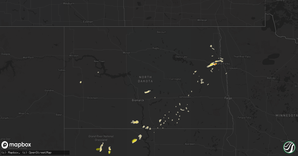
Hail Map in North Dakota on August 18, 2018
Get this storm
August 18 map
$229
one time, instant access
Download today. No call, no setup
Keep the $229
Bought the map and want the full workflow? Apply the entire $229 to a subscription within 7 days. None of it is wasted.
Every map, not just this one
This buys you this map. Subscription and you get every map we run, in the markets you choose from a few cities to whole states to nationwide. Plus real-time alerts the moment a storm fires.
Contact data
Name, contact info, occupancy, even credit band for addresses in the footprint. You go from where it hit to who to call.
Become the source they trust
Unlimited branding weather history reports on demand. You already have the documented answer ready for the property owner, and you are the one who showed up with it.
Property data and RoofTrace estimates
Pull up any address you have got, its value and the exact code rules for that jurisdiction, straight from One Click Code. Then RoofTrace estimates the squares, pitch, and roof value, priced the way you price.
Storm reports in North Dakota
North Dakota
| Date | Description |
|---|---|
| 08/18/20184:35 AM CDT | Very heavy rains and very strong winds impacted central melrose township... Flattening crops over several sections of farmland. Time estimated based on radar. |
| 08/18/20182:52 AM CDT | A few 3 to 5 inch diameter tree branches broken down at a number of homesites... Along with brief heavy rain and a few dime sized hail. |
| 08/18/20182:39 AM CDT | Deputy reported golf ball size hail. Relayed by dispatch. |
| 08/18/20182:36 AM CDT | Deputy reported golf ball size hail. Relayed by dispatch. |
All States Impacted by Hail Map on August 18, 2018
Cities Impacted by Hail Map on August 18, 2018
- Waverly, GA
- Elbert, CO
- Calhan, CO
- Peyton, CO
- Nemo, SD
- Deadwood, SD
- Reynolds, ND
- Strasburg, ND
- Pollock, SD
- Fort Pierre, SD
- Pecos, NM
- Ribera, NM
- Santa Fe, NM
- Glorieta, NM
- Littlefork, MN
- Oak Grove, LA
- Comanche, OK
- Erie, CO
- Longmont, CO
- Lafayette, CO
- Sterling, CO
- Otis, CO
- Tuthill, SD
- Tribune, KS
- Flagstaff, AZ
- Hatton, ND
- Sedona, AZ
- Fort Worth, TX
- Trinidad, CO
- Thermopolis, WY
- San Jon, NM
- Logan, NM
- Mosquero, NM
- Ulysses, KS
- Emerado, ND
- Mayer, AZ
- Jeffrey City, WY
- Ramah, CO
- Weed, NM
- McLaughlin, SD
- Trail City, SD
- Bard, NM
- Cotopaxi, CO
- Albany, TX
- Crook, CO
- Cody, NE
- Dickey, ND
- Selfridge, ND
- Fort Yates, ND
- Olla, LA
- Meadow, SD
- Gackle, ND
- Montpelier, ND
- Wishek, ND
- Stroud, OK
- Davenport, OK
- Chandler, OK
- Duncan, OK
- Raton, NM
- Boulder, CO
- Walsenburg, CO
- Valdez, NM
- San Cristobal, NM
- Spearman, TX
- Lakin, KS
- Big Falls, MN
- Bowie, TX
- Punta Gorda, FL
- Trementina, NM
- Lead, SD
- Manvel, ND
- Lehr, ND
- Lamar, CO
- Las Animas, CO
- Akron, CO
- White River, SD
- Okaton, SD
- Hayes, SD
- Midland, SD
- Arapahoe, CO
- Natchez, MS
- Fort Morgan, CO
- Conchas Dam, NM
- Colorado Springs, CO
- Celeste, TX
- Mer Rouge, LA
- Rayville, LA
- Oak Ridge, LA
- Oakley, KS
- International Falls, MN
- Loman, MN
- Sharon Springs, KS
- Weskan, KS
- Leoti, KS
- Syracuse, KS
- Jermyn, TX
- Loving, TX
- Bryson, TX
- Graham, TX
- Plano, TX
- Gurley, NE
- Mekinock, ND
- Larimore, ND
- Grand Forks, ND
- Arvilla, ND
- Grand Forks Afb, ND
- Northwood, ND
- Mormon Lake, AZ
- Brookhaven, MS
- McCall Creek, MS
- Meadville, MS
- Gainesville, TX
- Sanger, TX
- Pavillion, WY
- Kinnear, WY
- Hermitage, AR
- Bison, SD
- Kulm, ND
- Dupree, SD
- Anna, TX
- Celina, TX
- Mckinney, TX
- Van Alstyne, TX
- Woodbine, GA
- Monument, CO
- Larkspur, CO
- Wing, ND
- Sturgis, SD
- Fort Meade, SD
- Agate, CO
- Cimarron, NM
- Ashley, ND
- Ville Platte, LA
- Washington, LA
- Brunswick, GA
- Cheyenne, WY
- Granite Canon, WY
- Gilby, ND
- Black Canyon City, AZ
- Wanblee, SD
- Kirk, CO
- Joes, CO
- Bingham, NE
- North Richland Hills, TX
- Prescott, AZ
- Jacksboro, TX
- Windthorst, TX
- Henrietta, TX
- Wellington, CO
- Stratton, CO
- Scott City, KS
- Kit Carson, CO
- Spearfish, SD
- Whitewood, SD
- Holly, CO
- Capitan, NM
- Tinnie, NM
- Vona, CO
- Grand Prairie, TX
- Arlington, TX
- Casper, WY
- Trinchera, CO
- Fort Myers, FL
- Lovington, NM
- Ellsworth, NE
- Jacksonville, FL
- Grassy Butte, ND
- Kim, CO
- Pritchett, CO
- Driscoll, ND
- Kingsland, GA
- Hilliard, FL
- Yulee, FL
- Oshkosh, NE
- Kendall, KS
- Deer Trail, CO
- Byers, CO
- Belvidere, SD
- North Fort Myers, FL
- Turkey, TX
- Walters, OK
- Cape Coral, FL
- Grafton, ND
- Killdeer, ND
- Mandaree, ND
- Ardmore, OK
- Haxtun, CO
- Lodgepole, NE
- Fayette, MS
- Roxie, MS
- Breckenridge, TX
- Zeeland, ND
- Wakpala, SD
- Vega, TX
- Idabel, OK
- Glenwood, GA
- Grenville, NM
- Lewisville, TX
- Carrollton, TX
- Ponder, TX
- Krum, TX
- Sunset, TX
- Chico, TX
- Crescent, OK
- Guthrie, OK
- Roy, NM
- Cooperstown, ND
- Chidester, AR
- Piedmont, SD
- Rapid City, SD
- Black Hawk, SD
- Camden, AR
- Garita, NM
- Solano, NM
- Cypress, TX
- Houston, TX
- Springer, NM
- Mills, NM
- Iowa, LA
- Fleming, CO
- Yuma, CO
- Tallulah, LA
- Kabetogama, MN
- Wolfe City, TX
- Greenville, TX
- Aneta, ND
- Binford, ND
- Port Charlotte, FL
- Spiritwood, ND
- Marlow, OK
- Mcville, ND
- Tomball, TX
- Marion Junction, AL
- Bixby, OK
- Glenpool, OK
- Bismarck, ND
- East Grand Forks, MN
- Melissa, TX
- Buxton, ND
- Climax, MN
- Bonita, LA
- Warren, AR
- Cooper, TX
- Jones, LA
- Truth Or Consequences, NM
- Grayson, LA
- Jud, ND
- Edgeley, ND
- Dallas, TX
- The Colony, TX
- Frisco, TX
- Cornville, AZ
- Wimbledon, ND
- Bethune, CO
- Bastrop, LA
- Hamburg, AR
- Lake Charles, LA
- Era, TX
- Saint Francis, SD
- Rosston, TX
- Decatur, TX
- Burlington, CO
- Douglass, TX
- Charlton, MA
- Murdo, SD
- Sedgwick, CO
- Lake Creek, TX
- Wilmot, AR
- Hope, ND
- Goodridge, MN
- Thief River Falls, MN
- Hannaford, ND
- Luverne, ND
- Clarksville, TX
- Sidney, NE
- Monroe, LA
- Grady, NM
- Prosper, TX
- Regan, ND
- Baldwin, ND
- Fredonia, ND
- Irving, TX
- Coppell, TX
- Dorchester, SC
- Saint George, SC
- Tarrytown, GA
- Soperton, GA
- Herreid, SD
- Middleburg, FL
- Hague, ND
- Merriman, NE
- Meeteetse, WY
- Bellevue, TX
- Moscow, KS
- Temple, OK
- Finley, ND
- Wagon Mound, NM
- Broadview, NM
- Lake Providence, LA
- Aguilar, CO
- Worland, WY


