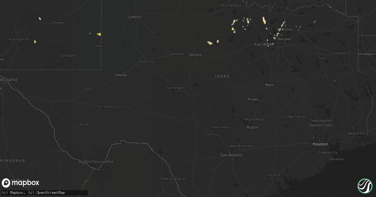
Hail Map in Texas on August 18, 2018
Get this storm
August 18 map
$229
one time, instant access
Download today. No call, no setup
Keep the $229
Bought the map and want the full workflow? Apply the entire $229 to a subscription within 7 days. None of it is wasted.
Every map, not just this one
This buys you this map. Subscription and you get every map we run, in the markets you choose from a few cities to whole states to nationwide. Plus real-time alerts the moment a storm fires.
Contact data
Name, contact info, occupancy, even credit band for addresses in the footprint. You go from where it hit to who to call.
Become the source they trust
Unlimited branding weather history reports on demand. You already have the documented answer ready for the property owner, and you are the one who showed up with it.
Property data and RoofTrace estimates
Pull up any address you have got, its value and the exact code rules for that jurisdiction, straight from One Click Code. Then RoofTrace estimates the squares, pitch, and roof value, priced the way you price.
Storm reports in Texas
Texas
| Date | Description |
|---|---|
| 08/18/20186:49 PM CDT | Large tree down in irving |
| 08/18/20186:41 PM CDT | Tree limbs down near intersection of park and custer. |
| 08/18/20186:27 PM CDT | Corrected for wind gust speed. Wind gust to 60 mph observed at denton enterprise airport |
| 08/18/20185:11 PM CDT | A least one trailer flipped upside down with damage to 3 others. Trees down. |
| 08/18/20183:51 PM CDT | Apparent microburst at dell city west texas mesonet site. |
| 08/18/20182:50 AM CDT | At 750 PM CDT, a severe thunderstorm was located near Frisco, moving northeast at 15 mph. HAZARD...60 mph wind gusts and nickel size hail. SOURCE...Radar indicated. IMPACT...Expect damage to roofs, siding, and trees. Locations impacted include... Plano, McKinney, Frisco, Allen, Prosper, Anna, Fairview, Princeton, Celina, Lucas, Parker, Van Alstyne, Lowry Crossing, Melissa, New Hope, Weston and Westminster. |
| 08/18/20181:25 AM CDT | At 624 PM CDT, a severe thunderstorm was located near Coppell, and is nearly stationary. Another severe storm was located near Grand Prairie and was also stationary. HAZARD...60 mph wind gusts and quarter size hail. SOURCE...Radar indicated. IMPACT...Hail damage to vehicles is expected. Expect wind damage to roofs, siding, and trees. Locations impacted include... Dallas, Irving, Grand Prairie, Carrollton, Euless, Grapevine, Coppell, Farmers Branch, University Park, Addison, Highland Park and Cockrell Hill.This includes the following interstates... Interstate 35E between mile markers 430 and 445. Interstate 30 between mile markers 32 and 44. |
| 08/18/201812:53 AM CDT | At 552 PM CDT, a severe thunderstorm was located near Sanger, moving southeast at 5 mph. HAZARD...60 mph wind gusts and quarter size hail. SOURCE...Radar indicated. IMPACT...Hail damage to vehicles is expected. Expect wind damage to roofs, siding, and trees. Locations impacted include... Denton, Sanger, Krum and Ponder. This includes the following interstates... Interstate 35 between mile markers 468 and 481. |
| 08/18/201812:53 AM CDT | At 552 PM CDT, a severe thunderstorm was located 7 miles southeast of Windthorst, and is nearly stationary. HAZARD...60 mph wind gusts and quarter size hail. SOURCE...Radar indicated. IMPACT...Hail damage to vehicles is expected. Expect wind damage to roofs, siding, and trees. Locations impacted include... Shannon. |
| 08/18/201812:41 AM CDT | At 541 PM CDT, a severe thunderstorm was located over Bowie, moving north at 5 mph. HAZARD...60 mph wind gusts and nickel size hail. SOURCE...Radar indicated. IMPACT...Expect damage to roofs, siding, and trees. Locations impacted include... Bowie, Stoneburg and Sunset. |
| 08/18/201812:40 AM CDT | At 540 PM CDT/440 PM MDT/, a severe thunderstorm was located near Carlsbad Caverns National Park, or 19 miles northeast of Pine Springs, and is nearly stationary. HAZARD...60 mph wind gusts and quarter size hail. SOURCE...Radar indicated. IMPACT...Hail damage to vehicles is expected. Expect wind damage to roofs, siding, and trees. Locations impacted include... Carlsbad Caverns National Park and Whites City. |
| 08/18/201812:38 AM CDT | At 538 PM CDT, a severe thunderstorm was located near Thackerville, and is nearly stationary. HAZARD...60 mph wind gusts and quarter size hail. SOURCE...Radar indicated. IMPACT...Hail damage to vehicles is expected. Expect wind damage to roofs, siding, and trees. Locations impacted include... Thackerville. |
| 08/17/201811:41 PM CDT | At 441 PM CDT, a severe thunderstorm was located 7 miles southwest of Sunset, or 10 miles south of Bowie, and is nearly stationary. HAZARD...60 mph wind gusts and penny size hail. SOURCE...Radar indicated. IMPACT...Expect damage to roofs, siding, and trees. Locations impacted include... Sunset. |
| 08/17/201811:00 PM CDT | A local report indicates 63 MPH wind near 2 SSW MULESHOE |
| 08/17/20188:17 PM CDT | Metal barn damaged |
| 08/17/20188:05 PM CDT | 3 to 6-inch diameter tree branches down along highway 455 between celina and weston. |
All States Impacted by Hail Map on August 18, 2018
Cities Impacted by Hail Map on August 18, 2018
- Waverly, GA
- Elbert, CO
- Calhan, CO
- Peyton, CO
- Nemo, SD
- Deadwood, SD
- Reynolds, ND
- Strasburg, ND
- Pollock, SD
- Fort Pierre, SD
- Pecos, NM
- Ribera, NM
- Santa Fe, NM
- Glorieta, NM
- Littlefork, MN
- Oak Grove, LA
- Comanche, OK
- Erie, CO
- Longmont, CO
- Lafayette, CO
- Sterling, CO
- Otis, CO
- Tuthill, SD
- Tribune, KS
- Flagstaff, AZ
- Hatton, ND
- Sedona, AZ
- Fort Worth, TX
- Trinidad, CO
- Thermopolis, WY
- San Jon, NM
- Logan, NM
- Mosquero, NM
- Ulysses, KS
- Emerado, ND
- Mayer, AZ
- Jeffrey City, WY
- Ramah, CO
- Weed, NM
- McLaughlin, SD
- Trail City, SD
- Bard, NM
- Cotopaxi, CO
- Albany, TX
- Crook, CO
- Cody, NE
- Dickey, ND
- Selfridge, ND
- Fort Yates, ND
- Olla, LA
- Meadow, SD
- Gackle, ND
- Montpelier, ND
- Wishek, ND
- Stroud, OK
- Davenport, OK
- Chandler, OK
- Duncan, OK
- Raton, NM
- Boulder, CO
- Walsenburg, CO
- Valdez, NM
- San Cristobal, NM
- Spearman, TX
- Lakin, KS
- Big Falls, MN
- Bowie, TX
- Punta Gorda, FL
- Trementina, NM
- Lead, SD
- Manvel, ND
- Lehr, ND
- Lamar, CO
- Las Animas, CO
- Akron, CO
- White River, SD
- Okaton, SD
- Hayes, SD
- Midland, SD
- Arapahoe, CO
- Natchez, MS
- Fort Morgan, CO
- Conchas Dam, NM
- Colorado Springs, CO
- Celeste, TX
- Mer Rouge, LA
- Rayville, LA
- Oak Ridge, LA
- Oakley, KS
- International Falls, MN
- Loman, MN
- Sharon Springs, KS
- Weskan, KS
- Leoti, KS
- Syracuse, KS
- Jermyn, TX
- Loving, TX
- Bryson, TX
- Graham, TX
- Plano, TX
- Gurley, NE
- Mekinock, ND
- Larimore, ND
- Grand Forks, ND
- Arvilla, ND
- Grand Forks Afb, ND
- Northwood, ND
- Mormon Lake, AZ
- Brookhaven, MS
- McCall Creek, MS
- Meadville, MS
- Gainesville, TX
- Sanger, TX
- Pavillion, WY
- Kinnear, WY
- Hermitage, AR
- Bison, SD
- Kulm, ND
- Dupree, SD
- Anna, TX
- Celina, TX
- Mckinney, TX
- Van Alstyne, TX
- Woodbine, GA
- Monument, CO
- Larkspur, CO
- Wing, ND
- Sturgis, SD
- Fort Meade, SD
- Agate, CO
- Cimarron, NM
- Ashley, ND
- Ville Platte, LA
- Washington, LA
- Brunswick, GA
- Cheyenne, WY
- Granite Canon, WY
- Gilby, ND
- Black Canyon City, AZ
- Wanblee, SD
- Kirk, CO
- Joes, CO
- Bingham, NE
- North Richland Hills, TX
- Prescott, AZ
- Jacksboro, TX
- Windthorst, TX
- Henrietta, TX
- Wellington, CO
- Stratton, CO
- Scott City, KS
- Kit Carson, CO
- Spearfish, SD
- Whitewood, SD
- Holly, CO
- Capitan, NM
- Tinnie, NM
- Vona, CO
- Grand Prairie, TX
- Arlington, TX
- Casper, WY
- Trinchera, CO
- Fort Myers, FL
- Lovington, NM
- Ellsworth, NE
- Jacksonville, FL
- Grassy Butte, ND
- Kim, CO
- Pritchett, CO
- Driscoll, ND
- Kingsland, GA
- Hilliard, FL
- Yulee, FL
- Oshkosh, NE
- Kendall, KS
- Deer Trail, CO
- Byers, CO
- Belvidere, SD
- North Fort Myers, FL
- Turkey, TX
- Walters, OK
- Cape Coral, FL
- Grafton, ND
- Killdeer, ND
- Mandaree, ND
- Ardmore, OK
- Haxtun, CO
- Lodgepole, NE
- Fayette, MS
- Roxie, MS
- Breckenridge, TX
- Zeeland, ND
- Wakpala, SD
- Vega, TX
- Idabel, OK
- Glenwood, GA
- Grenville, NM
- Lewisville, TX
- Carrollton, TX
- Ponder, TX
- Krum, TX
- Sunset, TX
- Chico, TX
- Crescent, OK
- Guthrie, OK
- Roy, NM
- Cooperstown, ND
- Chidester, AR
- Piedmont, SD
- Rapid City, SD
- Black Hawk, SD
- Camden, AR
- Garita, NM
- Solano, NM
- Cypress, TX
- Houston, TX
- Springer, NM
- Mills, NM
- Iowa, LA
- Fleming, CO
- Yuma, CO
- Tallulah, LA
- Kabetogama, MN
- Wolfe City, TX
- Greenville, TX
- Aneta, ND
- Binford, ND
- Port Charlotte, FL
- Spiritwood, ND
- Marlow, OK
- Mcville, ND
- Tomball, TX
- Marion Junction, AL
- Bixby, OK
- Glenpool, OK
- Bismarck, ND
- East Grand Forks, MN
- Melissa, TX
- Buxton, ND
- Climax, MN
- Bonita, LA
- Warren, AR
- Cooper, TX
- Jones, LA
- Truth Or Consequences, NM
- Grayson, LA
- Jud, ND
- Edgeley, ND
- Dallas, TX
- The Colony, TX
- Frisco, TX
- Cornville, AZ
- Wimbledon, ND
- Bethune, CO
- Bastrop, LA
- Hamburg, AR
- Lake Charles, LA
- Era, TX
- Saint Francis, SD
- Rosston, TX
- Decatur, TX
- Burlington, CO
- Douglass, TX
- Charlton, MA
- Murdo, SD
- Sedgwick, CO
- Lake Creek, TX
- Wilmot, AR
- Hope, ND
- Goodridge, MN
- Thief River Falls, MN
- Hannaford, ND
- Luverne, ND
- Clarksville, TX
- Sidney, NE
- Monroe, LA
- Grady, NM
- Prosper, TX
- Regan, ND
- Baldwin, ND
- Fredonia, ND
- Irving, TX
- Coppell, TX
- Dorchester, SC
- Saint George, SC
- Tarrytown, GA
- Soperton, GA
- Herreid, SD
- Middleburg, FL
- Hague, ND
- Merriman, NE
- Meeteetse, WY
- Bellevue, TX
- Moscow, KS
- Temple, OK
- Finley, ND
- Wagon Mound, NM
- Broadview, NM
- Lake Providence, LA
- Aguilar, CO
- Worland, WY


