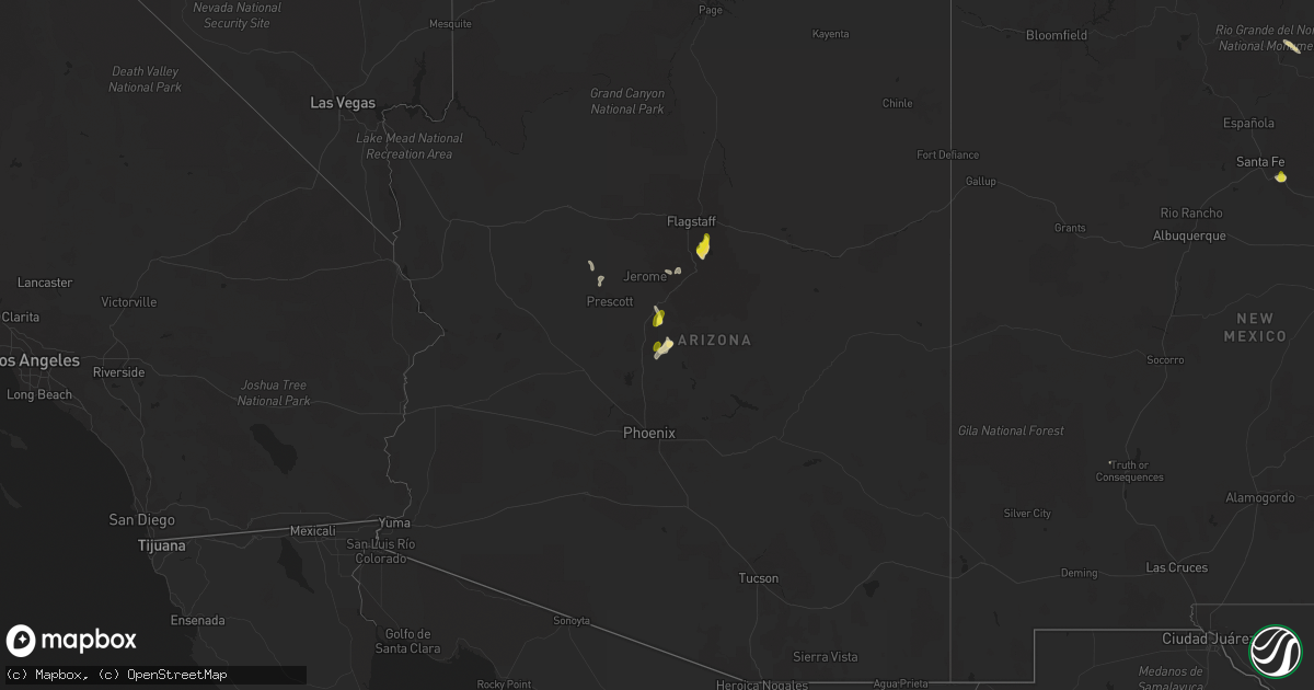
Hail Map in Arizona on August 18, 2018
Get this storm
August 18 map
$229
one time, instant access
Download today. No call, no setup
Keep the $229
Bought the map and want the full workflow? Apply the entire $229 to a subscription within 7 days. None of it is wasted.
Every map, not just this one
This buys you this map. Subscription and you get every map we run, in the markets you choose from a few cities to whole states to nationwide. Plus real-time alerts the moment a storm fires.
Contact data
Name, contact info, occupancy, even credit band for addresses in the footprint. You go from where it hit to who to call.
Become the source they trust
Unlimited branding weather history reports on demand. You already have the documented answer ready for the property owner, and you are the one who showed up with it.
Property data and RoofTrace estimates
Pull up any address you have got, its value and the exact code rules for that jurisdiction, straight from One Click Code. Then RoofTrace estimates the squares, pitch, and roof value, priced the way you price.
Storm reports in Arizona
Arizona
| Date | Description |
|---|---|
| 08/18/20186:58 PM CDT | A local report indicates 60 MPH wind near 2 SSE MIDDLE VERDE |
| 08/18/20184:22 PM CDT | Time lapse video shows narrow tornado at approximately 30 degree angle to the ground persisting for several minutes. |
| 08/17/201811:52 PM CDT | At 452 PM MST, a severe thunderstorm was located 7 miles west of Sunflower, moving south at 15 mph. HAZARD...60 mph wind gusts. SOURCE...Radar indicated. IMPACT...Expect damage to roofs, siding, and trees. Locations impacted include... Round Valley, Sugarloaf Mountain, Ballantine Trailhead and Rio Verde. |
| 08/17/201811:51 PM CDT | At 449 PM MST, a severe thunderstorm was located over Middle Verde and Camp Verde, moving south at 25 mph. HAZARD...60 mph wind gusts and penny size hail. SOURCE...Radar indicated. IMPACT...Expect damage to roofs, siding, and trees. Locations impacted include... Camp Verde, Montezuma Castle National Monument, Middle Verde, Mcguireville, Lake Montezuma and Clear Creek Campgrounds.This includes the following highways... Interstate 17 between mile markers 281 and 296. State Route 260 between mile markers 214 and 234. |
| 08/17/201811:08 PM CDT | At 408 PM MST, a severe thunderstorm was located near Clarkdale, or 12 miles west of Sedona, moving southeast at 20 mph. HAZARD...60 mph wind gusts and penny size hail. SOURCE...Radar indicated. IMPACT...Expect damage to roofs, siding, and trees. Locations impacted include... Clarkdale, Verde Village, Bridgeport, Cottonwood, Page Springs, Cornville, Dead Horse Ranch State Park and Tuzigoot National Monument.This includes the following highways... State Route 260 between mile markers 207 and 212. State Route 89A between mile markers 347 and 366. |
| 08/17/201810:51 PM CDT | At 350 PM MST, a severe thunderstorm was located 9 miles northeast of Cordes Lakes, or 14 miles southwest of Camp Verde, moving south at 15 mph. HAZARD...60 mph wind gusts and half dollar size hail. SOURCE...Radar indicated. IMPACT...Hail damage to vehicles is expected. Expect wind damage to roofs, siding, and trees. This severe thunderstorm will remain over mainly rural areas of Yavapai County, just east and northeast of Cordes Junction. |
| 08/17/201810:27 PM CDT | At 327 PM MST, a severe thunderstorm was located near Dairy Springs Campground, or 15 miles east of Sedona, moving southwest at 10 mph. HAZARD...60 mph wind gusts and quarter size hail. SOURCE...Radar indicated. IMPACT...Hail damage to vehicles is expected. Expect wind damage to roofs, siding, and trees. Locations impacted include... Mormon Lake, Munds Park, Dairy Springs Campground and Double Springs Campground.This includes Interstate 17 between mile markers 314 and 325. |
| 08/17/20189:46 PM CDT | At 245 PM MST, a severe thunderstorm was located near Dairy Springs Campground, or 14 miles southeast of Flagstaff, moving south at 10 mph. HAZARD...Quarter size hail. SOURCE...Radar indicated. IMPACT...Damage to vehicles is expected. Locations impacted include... Dairy Springs Campground, Mormon Lake, Upper Lake Mary, Double Springs Campground, Pinegrove Campground, Lake View Campground and Ashurst Lake Campgrounds. |
All States Impacted by Hail Map on August 18, 2018
Cities Impacted by Hail Map on August 18, 2018
- Waverly, GA
- Elbert, CO
- Calhan, CO
- Peyton, CO
- Nemo, SD
- Deadwood, SD
- Reynolds, ND
- Strasburg, ND
- Pollock, SD
- Fort Pierre, SD
- Pecos, NM
- Ribera, NM
- Santa Fe, NM
- Glorieta, NM
- Littlefork, MN
- Oak Grove, LA
- Comanche, OK
- Erie, CO
- Longmont, CO
- Lafayette, CO
- Sterling, CO
- Otis, CO
- Tuthill, SD
- Tribune, KS
- Flagstaff, AZ
- Hatton, ND
- Sedona, AZ
- Fort Worth, TX
- Trinidad, CO
- Thermopolis, WY
- San Jon, NM
- Logan, NM
- Mosquero, NM
- Ulysses, KS
- Emerado, ND
- Mayer, AZ
- Jeffrey City, WY
- Ramah, CO
- Weed, NM
- McLaughlin, SD
- Trail City, SD
- Bard, NM
- Cotopaxi, CO
- Albany, TX
- Crook, CO
- Cody, NE
- Dickey, ND
- Selfridge, ND
- Fort Yates, ND
- Olla, LA
- Meadow, SD
- Gackle, ND
- Montpelier, ND
- Wishek, ND
- Stroud, OK
- Davenport, OK
- Chandler, OK
- Duncan, OK
- Raton, NM
- Boulder, CO
- Walsenburg, CO
- Valdez, NM
- San Cristobal, NM
- Spearman, TX
- Lakin, KS
- Big Falls, MN
- Bowie, TX
- Punta Gorda, FL
- Trementina, NM
- Lead, SD
- Manvel, ND
- Lehr, ND
- Lamar, CO
- Las Animas, CO
- Akron, CO
- White River, SD
- Okaton, SD
- Hayes, SD
- Midland, SD
- Arapahoe, CO
- Natchez, MS
- Fort Morgan, CO
- Conchas Dam, NM
- Colorado Springs, CO
- Celeste, TX
- Mer Rouge, LA
- Rayville, LA
- Oak Ridge, LA
- Oakley, KS
- International Falls, MN
- Loman, MN
- Sharon Springs, KS
- Weskan, KS
- Leoti, KS
- Syracuse, KS
- Jermyn, TX
- Loving, TX
- Bryson, TX
- Graham, TX
- Plano, TX
- Gurley, NE
- Mekinock, ND
- Larimore, ND
- Grand Forks, ND
- Arvilla, ND
- Grand Forks Afb, ND
- Northwood, ND
- Mormon Lake, AZ
- Brookhaven, MS
- McCall Creek, MS
- Meadville, MS
- Gainesville, TX
- Sanger, TX
- Pavillion, WY
- Kinnear, WY
- Hermitage, AR
- Bison, SD
- Kulm, ND
- Dupree, SD
- Anna, TX
- Celina, TX
- Mckinney, TX
- Van Alstyne, TX
- Woodbine, GA
- Monument, CO
- Larkspur, CO
- Wing, ND
- Sturgis, SD
- Fort Meade, SD
- Agate, CO
- Cimarron, NM
- Ashley, ND
- Ville Platte, LA
- Washington, LA
- Brunswick, GA
- Cheyenne, WY
- Granite Canon, WY
- Gilby, ND
- Black Canyon City, AZ
- Wanblee, SD
- Kirk, CO
- Joes, CO
- Bingham, NE
- North Richland Hills, TX
- Prescott, AZ
- Jacksboro, TX
- Windthorst, TX
- Henrietta, TX
- Wellington, CO
- Stratton, CO
- Scott City, KS
- Kit Carson, CO
- Spearfish, SD
- Whitewood, SD
- Holly, CO
- Capitan, NM
- Tinnie, NM
- Vona, CO
- Grand Prairie, TX
- Arlington, TX
- Casper, WY
- Trinchera, CO
- Fort Myers, FL
- Lovington, NM
- Ellsworth, NE
- Jacksonville, FL
- Grassy Butte, ND
- Kim, CO
- Pritchett, CO
- Driscoll, ND
- Kingsland, GA
- Hilliard, FL
- Yulee, FL
- Oshkosh, NE
- Kendall, KS
- Deer Trail, CO
- Byers, CO
- Belvidere, SD
- North Fort Myers, FL
- Turkey, TX
- Walters, OK
- Cape Coral, FL
- Grafton, ND
- Killdeer, ND
- Mandaree, ND
- Ardmore, OK
- Haxtun, CO
- Lodgepole, NE
- Fayette, MS
- Roxie, MS
- Breckenridge, TX
- Zeeland, ND
- Wakpala, SD
- Vega, TX
- Idabel, OK
- Glenwood, GA
- Grenville, NM
- Lewisville, TX
- Carrollton, TX
- Ponder, TX
- Krum, TX
- Sunset, TX
- Chico, TX
- Crescent, OK
- Guthrie, OK
- Roy, NM
- Cooperstown, ND
- Chidester, AR
- Piedmont, SD
- Rapid City, SD
- Black Hawk, SD
- Camden, AR
- Garita, NM
- Solano, NM
- Cypress, TX
- Houston, TX
- Springer, NM
- Mills, NM
- Iowa, LA
- Fleming, CO
- Yuma, CO
- Tallulah, LA
- Kabetogama, MN
- Wolfe City, TX
- Greenville, TX
- Aneta, ND
- Binford, ND
- Port Charlotte, FL
- Spiritwood, ND
- Marlow, OK
- Mcville, ND
- Tomball, TX
- Marion Junction, AL
- Bixby, OK
- Glenpool, OK
- Bismarck, ND
- East Grand Forks, MN
- Melissa, TX
- Buxton, ND
- Climax, MN
- Bonita, LA
- Warren, AR
- Cooper, TX
- Jones, LA
- Truth Or Consequences, NM
- Grayson, LA
- Jud, ND
- Edgeley, ND
- Dallas, TX
- The Colony, TX
- Frisco, TX
- Cornville, AZ
- Wimbledon, ND
- Bethune, CO
- Bastrop, LA
- Hamburg, AR
- Lake Charles, LA
- Era, TX
- Saint Francis, SD
- Rosston, TX
- Decatur, TX
- Burlington, CO
- Douglass, TX
- Charlton, MA
- Murdo, SD
- Sedgwick, CO
- Lake Creek, TX
- Wilmot, AR
- Hope, ND
- Goodridge, MN
- Thief River Falls, MN
- Hannaford, ND
- Luverne, ND
- Clarksville, TX
- Sidney, NE
- Monroe, LA
- Grady, NM
- Prosper, TX
- Regan, ND
- Baldwin, ND
- Fredonia, ND
- Irving, TX
- Coppell, TX
- Dorchester, SC
- Saint George, SC
- Tarrytown, GA
- Soperton, GA
- Herreid, SD
- Middleburg, FL
- Hague, ND
- Merriman, NE
- Meeteetse, WY
- Bellevue, TX
- Moscow, KS
- Temple, OK
- Finley, ND
- Wagon Mound, NM
- Broadview, NM
- Lake Providence, LA
- Aguilar, CO
- Worland, WY


