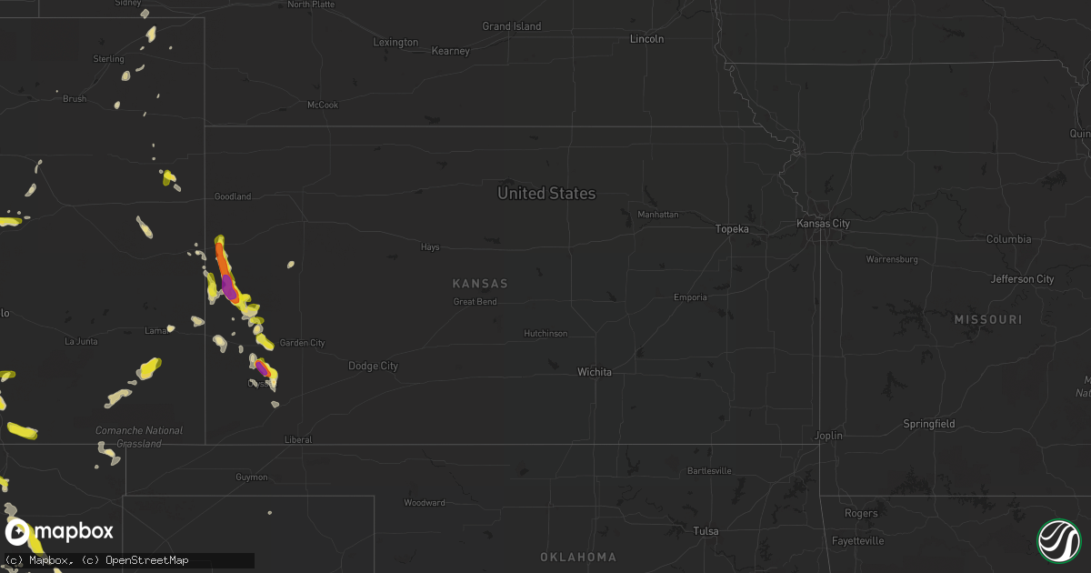
Hail Map in Kansas on August 18, 2018
Get this storm
August 18 map
$229
one time, instant access
Download today. No call, no setup
Keep the $229
Bought the map and want the full workflow? Apply the entire $229 to a subscription within 7 days. None of it is wasted.
Every map, not just this one
This buys you this map. Subscription and you get every map we run, in the markets you choose from a few cities to whole states to nationwide. Plus real-time alerts the moment a storm fires.
Contact data
Name, contact info, occupancy, even credit band for addresses in the footprint. You go from where it hit to who to call.
Become the source they trust
Unlimited branding weather history reports on demand. You already have the documented answer ready for the property owner, and you are the one who showed up with it.
Property data and RoofTrace estimates
Pull up any address you have got, its value and the exact code rules for that jurisdiction, straight from One Click Code. Then RoofTrace estimates the squares, pitch, and roof value, priced the way you price.
Storm reports in Kansas
Kansas
| Date | Description |
|---|---|
| 08/18/20186:50 PM CDT | House windows damaged. |
| 08/18/20186:50 PM CDT | A local report indicates 58 MPH wind near 5 S TRIBUNE |
| 08/18/20186:30 PM CDT | Corrects previous tstm wnd gst report from tribune. Report of tree blown down. |
| 08/18/20186:30 PM CDT | A local report indicates 1.00 inch wind near TRIBUNE |
| 08/18/20186:20 PM CDT | A local report indicates 68 MPH wind near 1 WNW HORACE |
| 08/18/20186:03 PM CDT | A local report indicates 1.00 inch wind near LAKIN |
| 08/18/20186:00 PM CDT | A local report indicates 1.00 inch wind near 2 NW LAKIN |
| 08/18/20185:40 PM CDT | Report of a tornado touching down briefly. |
| 08/18/20185:17 PM CDT | Nickel to quarter size hail fell. |
| 08/18/20183:28 AM CDT | At 827 PM CDT, a severe thunderstorm was located 7 miles north of Hickok, moving east at 5 mph. HAZARD...Up to Two inch hail and 60 mph wind gusts. SOURCE...Radar indicated. IMPACT...People and animals outdoors will be injured. Expect hail damage to roofs, siding, windows, and vehicles. Expect wind damage to roofs, siding, and trees. Locations impacted include... Hickok. |
| 08/18/20182:38 AM CDT | At 738 PM CDT, a severe thunderstorm was located 11 miles north of Ulysses, and is nearly stationary. HAZARD...Up to Two inch hail and 60 mph wind gusts. SOURCE...Radar indicated. IMPACT...People and animals outdoors will be injured. Expect hail damage to roofs, siding, windows, and vehicles. Expect wind damage to roofs, siding, and trees. This severe thunderstorm will remain over mainly rural areas of southeastern Kearny and northeastern Grant Counties. |
| 08/18/20182:08 AM CDT | At 708 PM CDT, a severe thunderstorm was located 12 miles north of Ulysses, and is nearly stationary. HAZARD...Up to Golf ball size hail and 60 mph wind gusts. SOURCE...Radar indicated. IMPACT...People and animals outdoors will be injured. Expect hail damage to roofs, siding, windows, and vehicles. Expect wind damage to roofs, siding, and trees. This severe thunderstorm will remain over mainly rural areas of southwestern Kearny and northern Grant Counties. |
| 08/18/20181:58 AM CDT | At 658 PM CDT/558 PM MDT/, a severe thunderstorm was located 10 miles southeast of Tribune, moving southeast at 15 mph. HAZARD...Up to Golf ball size hail and 60 mph wind gusts. SOURCE...Radar indicated. IMPACT...People and animals outdoors will be injured. Expect hail damage to roofs, siding, windows, and vehicles. Expect wind damage to roofs, siding, and trees. Locations impacted include... Coolidge. |
| 08/18/201812:55 AM CDT | At 555 PM CDT, a severe thunderstorm was located near Lakin, and is nearly stationary. HAZARD...60 mph wind gusts and half dollar size hail. SOURCE...Radar indicated. IMPACT...Hail damage to vehicles is expected. Expect wind damage to roofs, siding, and trees. Locations impacted include... Lakin and Deerfield. |
| 08/18/201812:24 AM CDT | At 524 PM MDT, a severe thunderstorm was located 4 miles east of Towner, or 13 miles west of Tribune, moving southeast at 20 mph. HAZARD...Ping pong ball size hail and 60 mph wind gusts. SOURCE...Radar indicated. IMPACT...People and animals outdoors will be injured. Expect hail damage to roofs, siding, windows, and vehicles. Expect wind damage to roofs, siding, and trees. This severe thunderstorm will remain over mainly rural areas of southwestern Greeley County. |
| 08/17/201811:43 PM CDT | At 443 PM MDT, a severe thunderstorm was located 8 miles north of Horace, or 9 miles north of Tribune, moving south at 30 mph. HAZARD...60 mph wind gusts and half dollar size hail. SOURCE...Radar indicated. IMPACT...Hail damage to vehicles is expected. Expect wind damage to roofs, siding, and trees. Locations impacted include... Tribune and Horace. |
| 08/17/20189:42 PM CDT | At 242 PM MDT, a severe thunderstorm was located 6 miles northwest of Sharon Springs, and is nearly stationary. HAZARD...60 mph wind gusts and quarter size hail. SOURCE...Radar indicated. IMPACT...Hail damage to vehicles is expected. Expect wind damage to roofs, siding, and trees. Locations impacted include... Sharon Springs. |
| 08/17/20188:49 PM CDT | Hen egg sized hail reported from earlier storm by a phone call 10 miles northeast of ulysses. |
| 08/17/20188:18 PM CDT | Quarter sized hail reported by em. |
| 08/17/20187:55 PM CDT | Quarter sized hail reported by em. |
| 08/17/20187:54 PM CDT | Multi-vortex briefly touched down northwest of ulysses spotted by storm chaser. |
| 08/17/20187:42 PM CDT | Quarter sized hail reported. |
| 08/17/20187:15 PM CDT | Quarter size hail reported by public. |
All States Impacted by Hail Map on August 18, 2018
Cities Impacted by Hail Map on August 18, 2018
- Waverly, GA
- Elbert, CO
- Calhan, CO
- Peyton, CO
- Nemo, SD
- Deadwood, SD
- Reynolds, ND
- Strasburg, ND
- Pollock, SD
- Fort Pierre, SD
- Pecos, NM
- Ribera, NM
- Santa Fe, NM
- Glorieta, NM
- Littlefork, MN
- Oak Grove, LA
- Comanche, OK
- Erie, CO
- Longmont, CO
- Lafayette, CO
- Sterling, CO
- Otis, CO
- Tuthill, SD
- Tribune, KS
- Flagstaff, AZ
- Hatton, ND
- Sedona, AZ
- Fort Worth, TX
- Trinidad, CO
- Thermopolis, WY
- San Jon, NM
- Logan, NM
- Mosquero, NM
- Ulysses, KS
- Emerado, ND
- Mayer, AZ
- Jeffrey City, WY
- Ramah, CO
- Weed, NM
- McLaughlin, SD
- Trail City, SD
- Bard, NM
- Cotopaxi, CO
- Albany, TX
- Crook, CO
- Cody, NE
- Dickey, ND
- Selfridge, ND
- Fort Yates, ND
- Olla, LA
- Meadow, SD
- Gackle, ND
- Montpelier, ND
- Wishek, ND
- Stroud, OK
- Davenport, OK
- Chandler, OK
- Duncan, OK
- Raton, NM
- Boulder, CO
- Walsenburg, CO
- Valdez, NM
- San Cristobal, NM
- Spearman, TX
- Lakin, KS
- Big Falls, MN
- Bowie, TX
- Punta Gorda, FL
- Trementina, NM
- Lead, SD
- Manvel, ND
- Lehr, ND
- Lamar, CO
- Las Animas, CO
- Akron, CO
- White River, SD
- Okaton, SD
- Hayes, SD
- Midland, SD
- Arapahoe, CO
- Natchez, MS
- Fort Morgan, CO
- Conchas Dam, NM
- Colorado Springs, CO
- Celeste, TX
- Mer Rouge, LA
- Rayville, LA
- Oak Ridge, LA
- Oakley, KS
- International Falls, MN
- Loman, MN
- Sharon Springs, KS
- Weskan, KS
- Leoti, KS
- Syracuse, KS
- Jermyn, TX
- Loving, TX
- Bryson, TX
- Graham, TX
- Plano, TX
- Gurley, NE
- Mekinock, ND
- Larimore, ND
- Grand Forks, ND
- Arvilla, ND
- Grand Forks Afb, ND
- Northwood, ND
- Mormon Lake, AZ
- Brookhaven, MS
- McCall Creek, MS
- Meadville, MS
- Gainesville, TX
- Sanger, TX
- Pavillion, WY
- Kinnear, WY
- Hermitage, AR
- Bison, SD
- Kulm, ND
- Dupree, SD
- Anna, TX
- Celina, TX
- Mckinney, TX
- Van Alstyne, TX
- Woodbine, GA
- Monument, CO
- Larkspur, CO
- Wing, ND
- Sturgis, SD
- Fort Meade, SD
- Agate, CO
- Cimarron, NM
- Ashley, ND
- Ville Platte, LA
- Washington, LA
- Brunswick, GA
- Cheyenne, WY
- Granite Canon, WY
- Gilby, ND
- Black Canyon City, AZ
- Wanblee, SD
- Kirk, CO
- Joes, CO
- Bingham, NE
- North Richland Hills, TX
- Prescott, AZ
- Jacksboro, TX
- Windthorst, TX
- Henrietta, TX
- Wellington, CO
- Stratton, CO
- Scott City, KS
- Kit Carson, CO
- Spearfish, SD
- Whitewood, SD
- Holly, CO
- Capitan, NM
- Tinnie, NM
- Vona, CO
- Grand Prairie, TX
- Arlington, TX
- Casper, WY
- Trinchera, CO
- Fort Myers, FL
- Lovington, NM
- Ellsworth, NE
- Jacksonville, FL
- Grassy Butte, ND
- Kim, CO
- Pritchett, CO
- Driscoll, ND
- Kingsland, GA
- Hilliard, FL
- Yulee, FL
- Oshkosh, NE
- Kendall, KS
- Deer Trail, CO
- Byers, CO
- Belvidere, SD
- North Fort Myers, FL
- Turkey, TX
- Walters, OK
- Cape Coral, FL
- Grafton, ND
- Killdeer, ND
- Mandaree, ND
- Ardmore, OK
- Haxtun, CO
- Lodgepole, NE
- Fayette, MS
- Roxie, MS
- Breckenridge, TX
- Zeeland, ND
- Wakpala, SD
- Vega, TX
- Idabel, OK
- Glenwood, GA
- Grenville, NM
- Lewisville, TX
- Carrollton, TX
- Ponder, TX
- Krum, TX
- Sunset, TX
- Chico, TX
- Crescent, OK
- Guthrie, OK
- Roy, NM
- Cooperstown, ND
- Chidester, AR
- Piedmont, SD
- Rapid City, SD
- Black Hawk, SD
- Camden, AR
- Garita, NM
- Solano, NM
- Cypress, TX
- Houston, TX
- Springer, NM
- Mills, NM
- Iowa, LA
- Fleming, CO
- Yuma, CO
- Tallulah, LA
- Kabetogama, MN
- Wolfe City, TX
- Greenville, TX
- Aneta, ND
- Binford, ND
- Port Charlotte, FL
- Spiritwood, ND
- Marlow, OK
- Mcville, ND
- Tomball, TX
- Marion Junction, AL
- Bixby, OK
- Glenpool, OK
- Bismarck, ND
- East Grand Forks, MN
- Melissa, TX
- Buxton, ND
- Climax, MN
- Bonita, LA
- Warren, AR
- Cooper, TX
- Jones, LA
- Truth Or Consequences, NM
- Grayson, LA
- Jud, ND
- Edgeley, ND
- Dallas, TX
- The Colony, TX
- Frisco, TX
- Cornville, AZ
- Wimbledon, ND
- Bethune, CO
- Bastrop, LA
- Hamburg, AR
- Lake Charles, LA
- Era, TX
- Saint Francis, SD
- Rosston, TX
- Decatur, TX
- Burlington, CO
- Douglass, TX
- Charlton, MA
- Murdo, SD
- Sedgwick, CO
- Lake Creek, TX
- Wilmot, AR
- Hope, ND
- Goodridge, MN
- Thief River Falls, MN
- Hannaford, ND
- Luverne, ND
- Clarksville, TX
- Sidney, NE
- Monroe, LA
- Grady, NM
- Prosper, TX
- Regan, ND
- Baldwin, ND
- Fredonia, ND
- Irving, TX
- Coppell, TX
- Dorchester, SC
- Saint George, SC
- Tarrytown, GA
- Soperton, GA
- Herreid, SD
- Middleburg, FL
- Hague, ND
- Merriman, NE
- Meeteetse, WY
- Bellevue, TX
- Moscow, KS
- Temple, OK
- Finley, ND
- Wagon Mound, NM
- Broadview, NM
- Lake Providence, LA
- Aguilar, CO
- Worland, WY


