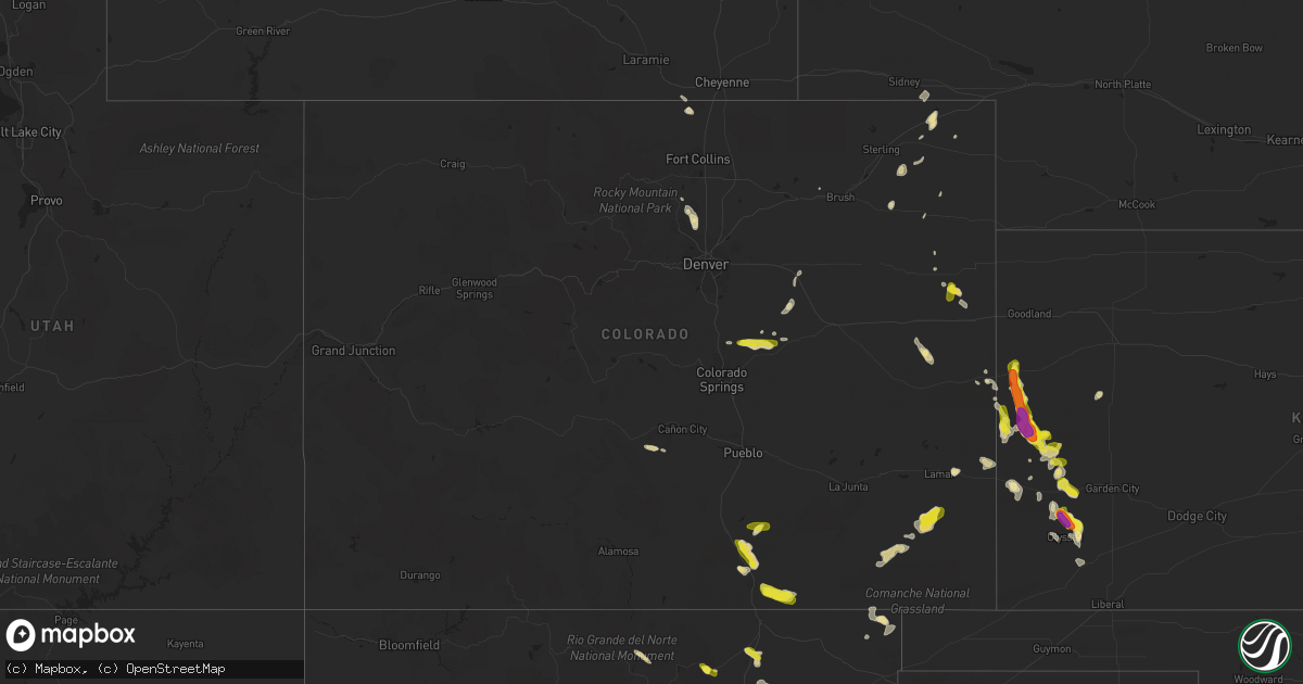
Hail Map in Colorado on August 18, 2018
Get this storm
August 18 map
$229
one time, instant access
Download today. No call, no setup
Keep the $229
Bought the map and want the full workflow? Apply the entire $229 to a subscription within 7 days. None of it is wasted.
Every map, not just this one
This buys you this map. Subscription and you get every map we run, in the markets you choose from a few cities to whole states to nationwide. Plus real-time alerts the moment a storm fires.
Contact data
Name, contact info, occupancy, even credit band for addresses in the footprint. You go from where it hit to who to call.
Become the source they trust
Unlimited branding weather history reports on demand. You already have the documented answer ready for the property owner, and you are the one who showed up with it.
Property data and RoofTrace estimates
Pull up any address you have got, its value and the exact code rules for that jurisdiction, straight from One Click Code. Then RoofTrace estimates the squares, pitch, and roof value, priced the way you price.
Storm reports in Colorado
Colorado
| Date | Description |
|---|---|
| 08/18/20181:38 PM CDT | A local report indicates 1.00 inch wind near 5 SSW ELLICOTT |
| 08/18/20181:38 PM CDT | A local report indicates 1.00 inch wind near 4 N PEYTON |
| 08/18/20187:35 AM CDT | At 1235 PM MDT, a severe thunderstorm was located near Peyton, or 26 miles northeast of Colorado Springs, moving southeast at 25 mph. HAZARD...60 mph wind gusts and half dollar size hail. SOURCE...Radar indicated. IMPACT...Hail damage to vehicles is expected. Expect wind damage to roofs, siding, and trees. Locations impacted include... Calhan, Ramah and Peyton. |
| 08/18/20185:10 AM CDT | At 1009 PM MDT, a severe thunderstorm was located near Erie, or 24 miles north of Denver, moving southeast at 30 mph. HAZARD...60 mph wind gusts and quarter size hail. SOURCE...Radar indicated. IMPACT...Expect damage to roofs, siding, and trees. Hail damage to vehicles is expected. Locations impacted include... Thornton, northeastern Westminster, eastern Longmont, northeastern Broomfield, Commerce City, Northglenn, Brighton, Lafayette, Erie, Firestone, Frederick, Fort Lupton, Lochbuie, Dacono, Barr Lake and Niwot. |
| 08/18/201812:53 AM CDT | At 553 PM MDT, a severe thunderstorm was located near Bristol, or 10 miles east of Lamar, moving northeast at 10 mph. HAZARD...60 mph wind gusts and half dollar size hail. SOURCE...Radar indicated. IMPACT...Hail damage to vehicles is expected. Expect wind damage to roofs, siding, and trees. Locations impacted include... Holly, Granada, Hartman and Bristol. |
| 08/18/201812:16 AM CDT | At 515 PM MDT, a severe thunderstorm was located 9 miles northwest of Two Buttes Reservoir, or 23 miles south of Lamar, moving northeast at 30 mph. HAZARD...Ping pong ball size hail and 60 mph wind gusts. SOURCE...Radar indicated. IMPACT...People and animals outdoors will be injured. Expect hail damage to roofs, siding, windows, and vehicles. Expect wind damage to roofs, siding, and trees. Locations impacted include... Two Buttes Reservoir. |
| 08/17/201811:01 PM CDT | At 400 PM MDT, a severe thunderstorm was located 11 miles southeast of Weskan, or 13 miles south of Sharon Springs, moving south at 20 mph. HAZARD...60 mph wind gusts and half dollar size hail. SOURCE...Radar indicated. IMPACT...Hail damage to vehicles is expected. Expect wind damage to roofs, siding, and trees. This severe thunderstorm will remain over mainly rural areas of northern Greeley County. |
| 08/17/201810:44 PM CDT | At 344 PM MDT, a severe thunderstorm was located 7 miles southwest of Sharon Springs, moving south at 10 mph. HAZARD...60 mph wind gusts and half dollar size hail. SOURCE...Radar indicated. IMPACT...Hail damage to vehicles is expected. Expect wind damage to roofs, siding, and trees. Locations impacted include... Sharon Springs, Weskan and Wallace. |
| 08/17/201810:23 PM CDT | At 322 PM MDT, a severe thunderstorm was located 16 miles north of Bethune, or 17 miles north of Stratton, moving northeast at 10 mph. HAZARD...60 mph wind gusts and half dollar size hail. SOURCE...Radar indicated. IMPACT...Hail damage to vehicles is expected. Expect wind damage to roofs, siding, and trees. This severe thunderstorm will remain over mainly rural areas of south central Yuma and north central Kit Carson Counties.This includes Highway 385 between mile markers 203 and 209, and nearmile marker 211. |
| 08/17/201810:21 PM CDT | At 320 PM MDT, a severe thunderstorm was located 10 miles west of Trinchera, or 17 miles east of Trinidad, moving east at 30 mph. HAZARD...60 mph wind gusts and half dollar size hail. SOURCE...Radar indicated. IMPACT...Hail damage to vehicles is expected. Expect wind damage to roofs, siding, and trees. Locations impacted include... Branson and Trinchera. |
| 08/17/201810:04 PM CDT | At 304 PM MDT, a severe thunderstorm was located 5 miles east of Weskan, or 6 miles west of Sharon Springs, moving south at 15 mph. HAZARD...Ping pong ball size hail and 60 mph wind gusts. SOURCE...Radar indicated. IMPACT...People and animals outdoors will be injured. Expect hail damage to roofs, siding, windows, and vehicles. Expect wind damage to roofs, siding, and trees. Locations impacted include... Sharon Springs and Weskan. |
| 08/17/20189:12 PM CDT | At 212 PM MDT, a severe thunderstorm was located near Aguilar, or 13 miles northwest of Trinidad, moving southeast at 15 mph. HAZARD...70 mph wind gusts and ping pong ball size hail. SOURCE...Radar indicated. IMPACT...People and animals outdoors will be injured. Expect hail damage to roofs, siding, windows, and vehicles. Expect considerable tree damage. Wind damage is also likely to mobile homes, roofs, and outbuildings. Locations impacted include... Trinidad, Starkville, Model and Hoehne. |
| 08/17/20188:49 PM CDT | At 148 PM MDT, a severe thunderstorm was located near Aguilar, or 23 miles north of Trinidad, moving southeast at 15 mph. HAZARD...60 mph wind gusts and half dollar size hail. SOURCE...Radar indicated. IMPACT...Hail damage to vehicles is expected. Expect wind damage to roofs, siding, and trees. This severe thunderstorm will remain over mainly rural areas of east central Huerfano and central Las Animas Counties. |
All States Impacted by Hail Map on August 18, 2018
Cities Impacted by Hail Map on August 18, 2018
- Waverly, GA
- Elbert, CO
- Calhan, CO
- Peyton, CO
- Nemo, SD
- Deadwood, SD
- Reynolds, ND
- Strasburg, ND
- Pollock, SD
- Fort Pierre, SD
- Pecos, NM
- Ribera, NM
- Santa Fe, NM
- Glorieta, NM
- Littlefork, MN
- Oak Grove, LA
- Comanche, OK
- Erie, CO
- Longmont, CO
- Lafayette, CO
- Sterling, CO
- Otis, CO
- Tuthill, SD
- Tribune, KS
- Flagstaff, AZ
- Hatton, ND
- Sedona, AZ
- Fort Worth, TX
- Trinidad, CO
- Thermopolis, WY
- San Jon, NM
- Logan, NM
- Mosquero, NM
- Ulysses, KS
- Emerado, ND
- Mayer, AZ
- Jeffrey City, WY
- Ramah, CO
- Weed, NM
- McLaughlin, SD
- Trail City, SD
- Bard, NM
- Cotopaxi, CO
- Albany, TX
- Crook, CO
- Cody, NE
- Dickey, ND
- Selfridge, ND
- Fort Yates, ND
- Olla, LA
- Meadow, SD
- Gackle, ND
- Montpelier, ND
- Wishek, ND
- Stroud, OK
- Davenport, OK
- Chandler, OK
- Duncan, OK
- Raton, NM
- Boulder, CO
- Walsenburg, CO
- Valdez, NM
- San Cristobal, NM
- Spearman, TX
- Lakin, KS
- Big Falls, MN
- Bowie, TX
- Punta Gorda, FL
- Trementina, NM
- Lead, SD
- Manvel, ND
- Lehr, ND
- Lamar, CO
- Las Animas, CO
- Akron, CO
- White River, SD
- Okaton, SD
- Hayes, SD
- Midland, SD
- Arapahoe, CO
- Natchez, MS
- Fort Morgan, CO
- Conchas Dam, NM
- Colorado Springs, CO
- Celeste, TX
- Mer Rouge, LA
- Rayville, LA
- Oak Ridge, LA
- Oakley, KS
- International Falls, MN
- Loman, MN
- Sharon Springs, KS
- Weskan, KS
- Leoti, KS
- Syracuse, KS
- Jermyn, TX
- Loving, TX
- Bryson, TX
- Graham, TX
- Plano, TX
- Gurley, NE
- Mekinock, ND
- Larimore, ND
- Grand Forks, ND
- Arvilla, ND
- Grand Forks Afb, ND
- Northwood, ND
- Mormon Lake, AZ
- Brookhaven, MS
- McCall Creek, MS
- Meadville, MS
- Gainesville, TX
- Sanger, TX
- Pavillion, WY
- Kinnear, WY
- Hermitage, AR
- Bison, SD
- Kulm, ND
- Dupree, SD
- Anna, TX
- Celina, TX
- Mckinney, TX
- Van Alstyne, TX
- Woodbine, GA
- Monument, CO
- Larkspur, CO
- Wing, ND
- Sturgis, SD
- Fort Meade, SD
- Agate, CO
- Cimarron, NM
- Ashley, ND
- Ville Platte, LA
- Washington, LA
- Brunswick, GA
- Cheyenne, WY
- Granite Canon, WY
- Gilby, ND
- Black Canyon City, AZ
- Wanblee, SD
- Kirk, CO
- Joes, CO
- Bingham, NE
- North Richland Hills, TX
- Prescott, AZ
- Jacksboro, TX
- Windthorst, TX
- Henrietta, TX
- Wellington, CO
- Stratton, CO
- Scott City, KS
- Kit Carson, CO
- Spearfish, SD
- Whitewood, SD
- Holly, CO
- Capitan, NM
- Tinnie, NM
- Vona, CO
- Grand Prairie, TX
- Arlington, TX
- Casper, WY
- Trinchera, CO
- Fort Myers, FL
- Lovington, NM
- Ellsworth, NE
- Jacksonville, FL
- Grassy Butte, ND
- Kim, CO
- Pritchett, CO
- Driscoll, ND
- Kingsland, GA
- Hilliard, FL
- Yulee, FL
- Oshkosh, NE
- Kendall, KS
- Deer Trail, CO
- Byers, CO
- Belvidere, SD
- North Fort Myers, FL
- Turkey, TX
- Walters, OK
- Cape Coral, FL
- Grafton, ND
- Killdeer, ND
- Mandaree, ND
- Ardmore, OK
- Haxtun, CO
- Lodgepole, NE
- Fayette, MS
- Roxie, MS
- Breckenridge, TX
- Zeeland, ND
- Wakpala, SD
- Vega, TX
- Idabel, OK
- Glenwood, GA
- Grenville, NM
- Lewisville, TX
- Carrollton, TX
- Ponder, TX
- Krum, TX
- Sunset, TX
- Chico, TX
- Crescent, OK
- Guthrie, OK
- Roy, NM
- Cooperstown, ND
- Chidester, AR
- Piedmont, SD
- Rapid City, SD
- Black Hawk, SD
- Camden, AR
- Garita, NM
- Solano, NM
- Cypress, TX
- Houston, TX
- Springer, NM
- Mills, NM
- Iowa, LA
- Fleming, CO
- Yuma, CO
- Tallulah, LA
- Kabetogama, MN
- Wolfe City, TX
- Greenville, TX
- Aneta, ND
- Binford, ND
- Port Charlotte, FL
- Spiritwood, ND
- Marlow, OK
- Mcville, ND
- Tomball, TX
- Marion Junction, AL
- Bixby, OK
- Glenpool, OK
- Bismarck, ND
- East Grand Forks, MN
- Melissa, TX
- Buxton, ND
- Climax, MN
- Bonita, LA
- Warren, AR
- Cooper, TX
- Jones, LA
- Truth Or Consequences, NM
- Grayson, LA
- Jud, ND
- Edgeley, ND
- Dallas, TX
- The Colony, TX
- Frisco, TX
- Cornville, AZ
- Wimbledon, ND
- Bethune, CO
- Bastrop, LA
- Hamburg, AR
- Lake Charles, LA
- Era, TX
- Saint Francis, SD
- Rosston, TX
- Decatur, TX
- Burlington, CO
- Douglass, TX
- Charlton, MA
- Murdo, SD
- Sedgwick, CO
- Lake Creek, TX
- Wilmot, AR
- Hope, ND
- Goodridge, MN
- Thief River Falls, MN
- Hannaford, ND
- Luverne, ND
- Clarksville, TX
- Sidney, NE
- Monroe, LA
- Grady, NM
- Prosper, TX
- Regan, ND
- Baldwin, ND
- Fredonia, ND
- Irving, TX
- Coppell, TX
- Dorchester, SC
- Saint George, SC
- Tarrytown, GA
- Soperton, GA
- Herreid, SD
- Middleburg, FL
- Hague, ND
- Merriman, NE
- Meeteetse, WY
- Bellevue, TX
- Moscow, KS
- Temple, OK
- Finley, ND
- Wagon Mound, NM
- Broadview, NM
- Lake Providence, LA
- Aguilar, CO
- Worland, WY


