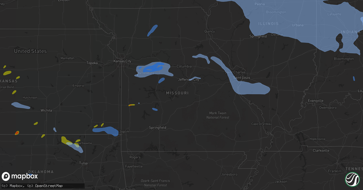
Hail Map in Missouri on August 10, 2020
Get this storm
August 10 map
$229
one time, instant access
Download today. No call, no setup
Keep the $229
Bought the map and want the full workflow? Apply the entire $229 to a subscription within 7 days. None of it is wasted.
Every map, not just this one
This buys you this map. Subscription and you get every map we run, in the markets you choose from a few cities to whole states to nationwide. Plus real-time alerts the moment a storm fires.
Contact data
Name, contact info, occupancy, even credit band for addresses in the footprint. You go from where it hit to who to call.
Become the source they trust
Unlimited branding weather history reports on demand. You already have the documented answer ready for the property owner, and you are the one who showed up with it.
Property data and RoofTrace estimates
Pull up any address you have got, its value and the exact code rules for that jurisdiction, straight from One Click Code. Then RoofTrace estimates the squares, pitch, and roof value, priced the way you price.
Storm reports in Missouri
Missouri
| Date | Description |
|---|---|
| 08/10/20206:58 PM CDT | Trees down. |
| 08/10/20206:57 PM CDT | Trees down in wheatland park. |
| 08/10/20206:40 PM CDT | Tennis ball size hail. Via social media. Delayed report. |
| 08/10/20206:28 PM CDT | Mesonet station wktm7 wah kon tah raws. |
| 08/10/20206:14 PM CDT | Tree down on route cc. |
| 08/10/20206:10 PM CDT | Delayed report: awning material removed from a structure on the property. Several trees down in the area southeast of the i-55/255 junction. |
| 08/10/20206:07 PM CDT | Sheriff reported ping pong sized hail along with a tree blown over. |
| 08/10/20206:05 PM CDT | Dispatch office reported hail the size of a half dollar. Time based on radar. |
| 08/10/20206:04 PM CDT | A large maple tree down on a house. The house suffered damage to the awning and gutters before rolling off the slanted roof. Power lines are also down in the area. Spot |
| 08/10/20206:04 PM CDT | Strong winds were also reported... But no measurement or estimate was given. |
| 08/10/20206:04 PM CDT | 10 inch branch down at old hwy m and old lemay ferry road. |
| 08/10/20206:00 PM CDT | Several 2 inch maple tree branches down near i-255 and telegraph raod. |
| 08/10/20206:00 PM CDT | Power lines reported down near highlands plaza drive south of i-64/40. Power was out in the area. |
| 08/10/20206:00 PM CDT | Power pole down at the 3800 block of shaw blvd. |
| 08/10/20206:00 PM CDT | 3-4 inch tree limbs down at gerald drive and tesson ferry road. |
| 08/10/20206:00 PM CDT | Delayed social media report of a tree limb down in a residential area. Limbs look to be about 6-8 inches in diameter. |
| 08/10/20205:55 PM CDT | Delayed report of a large tree down on power lines near ameling road and bennington place. It was noted that several large trees were down in the area. Time estimated b |
| 08/10/20205:55 PM CDT | Delayed report of a tree down on some power lines near rose acres and mckelvy. Time estimated by radar. |
| 08/10/20205:55 PM CDT | 1-2 inch tree limbs down... Power is out. |
| 08/10/20205:55 PM CDT | 5-6 inch tree limb down in tower grove south. |
| 08/10/20205:50 PM CDT | Power poles down along the service road. |
| 08/10/20205:46 PM CDT | Reported power line down causing power outages in neosho. Time based on radar. |
| 08/10/20205:45 PM CDT | Large trees and power lines down. |
| 08/10/20205:45 PM CDT | Large tree limb down on creve coeur mill road at thomas patrick court. |
| 08/10/20205:45 PM CDT | Branches down at creve coeur park lake front. Portable traffic control sign blown over. |
| 08/10/20205:41 PM CDT | Public reported a tree was down on a house off jungs station road in st. Peters. The fire dept was on the scene. |
| 08/10/20205:40 PM CDT | 8-12 inch tree limbs down on pralle lane. |
| 08/10/20205:40 PM CDT | 6-8 inch tree limbs down... Short light pole down. |
| 08/10/20205:38 PM CDT | Via social media report of 2 inch size tree branches down. Time based on radar. |
| 08/10/20205:38 PM CDT | Tree down over hwy dd near sommers road. |
| 08/10/20205:37 PM CDT | Gust observed by asos at spirit of st. Louis airport. |
| 08/10/20205:36 PM CDT | 1-2 inch softwood tree branches down at tom ginnever ave and st. Matthew ave. |
| 08/10/20205:35 PM CDT | 4-5 inch diameter limbs down... Pea to small marble sized hail. |
| 08/10/20205:35 PM CDT | 6 inch tree limbs down. |
| 08/10/20205:30 PM CDT | Via social media. Delayed report. Hail 2 to 2.5 inches. Time based on radar. |
| 08/10/20205:26 PM CDT | Tree down on hwy ww. |
| 08/10/20205:17 PM CDT | 12 inch diameter tree limb snapped and fell on garage. |
| 08/10/20205:12 PM CDT | Quarter size hail behind camp clark. Delayed report via social media. |
| 08/10/20205:12 PM CDT | Trees uprooted in very wet soil. |
| 08/10/20205:12 PM CDT | Two large highway signs blown down along hwy 61 near mile marker 47. |
| 08/10/20205:00 PM CDT | 6 inch tree limbs down... Wind blew into an open east-west facing gable barn and tore the tin roof halfway off. |
| 08/10/20204:40 PM CDT | Trees uprooted in very wet soil. |
| 08/10/20204:36 PM CDT | A local report indicates 60 MPH wind near 2 NE JEFFERSON CITY |
| 08/10/20204:33 PM CDT | A local report indicates 58 MPH wind near 2 N COLUMBIA |
| 08/10/20204:22 PM CDT | Two inch tree limbs down. |
| 08/10/20203:39 PM CDT | Maple tree downed in boonville. Numerous other trees damaged/ limbs blown down. |
| 08/10/20202:58 PM CDT | Home flagpole snapped and blown down. |
| 08/10/20202:45 PM CDT | Large tree limbs blown down on house. |
| 08/10/20202:45 PM CDT | Large tree blown down along highway 13 south of hale lake rd. Time estimated from radar. |
| 08/10/20202:40 PM CDT | A local report indicates 70 MPH wind near 4 ESE PITTSVILLE |
| 08/10/20202:24 PM CDT | Power lines down within the city of holden. |
| 08/10/20201:06 PM CDT | Power pole snapped at the intersection of highway 190 and highway p. |
| 08/10/20201:06 PM CDT | Several large limbs and power lines down on highway f near the intersection of highway u. |
| 08/10/20201:04 PM CDT | Several trees uprooted. Metal farm outbuildings heavily damaged. Aluminum grain trailer blown over. |
| 08/10/202012:49 PM CDT | Trained spotter reported trees down in memphis. This happened before any rain or storms arrived. |
| 08/10/202011:24 AM CDT | Emergency manager reported winds of around 60 mph moved through the eagleville to blythdale area. |
| 08/10/202011:24 AM CDT | Report of an extended power outage between eagleville to blytheville due to an estimated 24 inch diameter healthy limb falling on and breaking power lines. |
| 08/10/20207:58 AM CDT | At 1258 PM CDT, severe thunderstorms were located along a line extending from near Pattonsburg to 8 miles northeast of Gallatin to Jamesport to 11 miles south of Trenton to near Chillicothe, moving northeast at 25 mph. HAZARD...60 mph wind gusts and penny size hail. SOURCE...Emergency management. IMPACT...Expect damage to roofs, siding, and trees. Locations impacted include... Chillicothe, Trenton, Bethany, Princeton, Jamesport, Ridgeway, Gilman City, Pattonsburg, Eagleville, Cainsville, Linneus, Wheeling, Browning, Spickard, Galt, Chula, Laredo, Blythedale, Purdin and Coffey.This includes Interstate 35 in Missouri between mile markers 71 and109. |
| 08/10/20207:42 AM CDT | At 1242 PM CDT, severe thunderstorms were located along a line extending from near Lone Tree to near Lockridge, moving east at 65 mph. HAZARD...60 mph wind gusts. SOURCE...Trained weather spotters. IMPACT...Expect damage to roofs, siding, and trees. Locations impacted include... Rock Island, Burlington, Muscatine, Fort Madison, Mount Pleasant, Washington, Aledo, Wapello, Columbus Junction, Oquawka, Milan, Coal Valley, West Burlington, Burgess, New London, Mediapolis, Lone Tree, Andalusia, Winfield and Riverside. |
| 08/10/20207:05 AM CDT | At 1205 PM CDT, severe thunderstorms were located along a line extending from near Hedrick to near Lake Sundown, moving east at 45 mph. HAZARD...60 mph wind gusts. SOURCE...Radar indicated. IMPACT...Expect damage to roofs, siding, and trees. Locations impacted include... Fairfield, Keosauqua, Hedrick, Brighton, Richland, Batavia, Birmingham, Milton, Bonaparte, Libertyville, Stockport, Lockridge, Maharishi Vedic City, Cantril, Packwood, Martinsburg, Pleasant Plain, Abingdon, Douds and Bentonsport/Vernon. |
| 08/10/20206:58 AM CDT | At 1158 AM CDT, severe thunderstorms were located along a line extending from 7 miles southeast of Oskaloosa to 7 miles north of Unionville, moving east at 45 mph. These winds are from outflow from storms to the north and west. HAZARD...60 mph wind gusts. SOURCE...Trained weather spotters. IMPACT...Expect damage to roofs, siding, and trees. Locations impacted include... Ottumwa, Centerville, Bloomfield, Ottumwa Industrial Airport, Lake Sundown, Eldon, Fremont, Agency, Moulton, Cincinnati, Blakesburg, Pulaski, Drakesville, Kirkville, Exline, Floris, Unionville, Chillicothe, Udell and Sharon Bluffs State Park. |
| 08/10/20204:25 AM CDT | At 924 AM CDT, severe thunderstorms were located along a line extending from 5 miles north of Glenwood to 6 miles northwest of Bennet, moving southeast at 60 mph. HAZARD...60 mph wind gusts. SOURCE...Trained weather spotters. IMPACT...Expect damage to roofs, siding, and trees. Severe thunderstorms will be near... South Lincoln at 925 AM CDT. Glenwood around 930 AM CDT. Malvern around 935 AM CDT. Emerson, Unadilla and Douglas around 940 AM CDT. Syracuse around 945 AM CDT. Red Oak around 950 AM CDT. Essex, Stanton, Talmage and Lorton around 955 AM CDT.Other locations impacted by these severe thunderstorms includeThurman, Grant, Camp Catron, Manley, Hastings, Coburg, Burr,Waubonsie State Park, Silver City and Pierce Recreation Area.This includes Interstate 29 between mile markers 1 and 39. |
| 08/10/20202:36 AM CDT | At 735 PM CDT, severe thunderstorms were located along a line extending from 8 miles west of Mcleansboro to near Murphysboro, moving east at 65 mph. HAZARD...60 mph wind gusts. SOURCE...Radar indicated. IMPACT...Expect damage to roofs, siding, and trees. Locations impacted include... Carbondale, Marion, Herrin, West Frankfort, Murphysboro, Carterville, Johnston City, Christopher, Zeigler, De Soto, Crainville, Cambria, Royalton, Energy, Elkville, Hurst, Ava, Grand Tower, Pittsburg and Creal Springs.This includes the following highways... Interstate 24 in Illinois between Mile Markers 1 and 2. Interstate 57 in Illinois between Mile Markers 43 and 69. |
| 08/10/20201:54 AM CDT | At 654 PM CDT, severe thunderstorms were located along a line extending from near Hermitage to near Urbana to 10 miles north of Bolivar to near Humansville, moving east at 35 mph. HAZARD...60 mph wind gusts and nickel size hail. SOURCE...Radar indicated. IMPACT...Expect damage to roofs, siding, and trees. Locations impacted include... Pomme de Terre Lake... Pomme De Terre State Park... Bennett Spring State Park... Buffalo... Pittsburg... Polk... Hermitage... Urbana... Wheatland... Macks Creek... Preston... Halfway... Flemington... Louisburg... Windyville... Quincy... Tunas... Pumpkin Center... Branch... Plad... |
| 08/10/20201:00 AM CDT | At 559 PM CDT, a severe thunderstorm was located 1 mile east of Rolla, moving east at 25 mph. HAZARD...60 mph wind gusts and quarter size hail. SOURCE...Radar indicated. IMPACT...Hail damage to vehicles is expected. Expect wind damage to roofs, siding, and trees. Locations impacted include... East Rolla... St. James... Rosati... This includes Interstate 44 between mile markers 189 and 200. |
| 08/10/202012:59 AM CDT | At 559 PM CDT, severe thunderstorms were located along a line extending from Black Jack to near Antonia to near De Soto, moving east at 40 mph. HAZARD...60 mph wind gusts. SOURCE...Trained weather spotters. IMPACT...Expect damage to roofs, siding, and trees. Locations impacted include... St. Louis, Belleville, University City, Granite City, O'Fallon, East St. Louis, Collinsville, Edwardsville, Webster Groves, Ferguson, Arnold, Fairview Heights, Clayton, Cahokia, Jennings, Swansea, Glen Carbon, Shiloh, Crestwood and Festus.This includes the following highways... Interstate 70 in Illinois between exits 21 and 30. Interstate 55 in Illinois near exit 23. Interstate 64 in Illinois between exits 9 and 61. Interstate 55 in Missouri between exits 170 and 191.This also includes Scott Joplin Historic Site, Mastodon HistoricSite, Gov. Dunklin's Grave Historic Site, Carlyle Lake RecreationalArea, and Horseshoe Lake State Park. |
| 08/10/202012:47 AM CDT | At 547 PM CDT, a severe thunderstorm was located over Salem, moving east at 10 mph. HAZARD...60 mph wind gusts and nickel size hail. SOURCE...Radar indicated. IMPACT...Expect damage to roofs, siding, and trees. Locations impacted include... Salem... Boss... Howes... Stone Hill... Howes Mill... |
| 08/10/202012:26 AM CDT | At 525 PM CDT, a severe thunderstorm was located near Walker, or 8 miles east of Nevada, moving east at 20 mph. HAZARD...60 mph wind gusts and half dollar size hail. SOURCE...Radar indicated. IMPACT...Hail damage to vehicles is expected. Expect wind damage to roofs, siding, and trees. Locations impacted include... El Dorado Springs... Walker... Taberville... Caplinger Mills... Cedar Springs... Tiffin... |
| 08/10/202012:16 AM CDT | At 514 PM CDT, severe thunderstorms were located along a line extending from near Bunker Hill to near St. Paul to Beaufort, moving southeast at 45 mph. HAZARD...60 mph wind gusts. SOURCE...Law enforcement. IMPACT...Expect damage to roofs, siding, and trees. Locations impacted include... St. Louis, St. Charles, St. Peters, Florissant, Chesterfield, Belleville, Wildwood, University City, Ballwin, Granite City, Wentzville, O'Fallon, Alton, Kirkwood, Maryland Heights, East St. Louis, Hazelwood, Collinsville, Edwardsville and Webster Groves.This includes the following highways... Interstate 70 in Illinois between exits 21 and 30. Interstate 55 in Illinois between exits 23 and 44. Interstate 64 in Illinois between exits 9 and 27. Interstate 44 in Missouri between exits 230 and 277. Interstate 55 in Missouri between exits 175 and 191. Interstate 70 in Missouri between exits 212 and 231.This also includes Babler Memorial State Park, Scott Joplin HistoricSite, Route 66 State Park, Castlewood State Park, Confluence StatePark, Mastodon Historic Site, Sandy Creek Covered Bridge HistoricSite, Gov. Dunklin's Grave Historic Site, First Missouri StateCapitol Historic Site, Robertsville State Park, and Horseshoe LakeState Park. |
| 08/09/202011:39 PM CDT | At 438 PM CDT, severe thunderstorms were located along a line extending from Montgomery City to near Chamois to near Taos, moving east at 45 mph. HAZARD...60 mph wind gusts and penny size hail. SOURCE...Automated weather station in Jefferson City reported a wind gust of 60 miles per hour. IMPACT...Expect damage to roofs, siding, and trees. Locations impacted include... O'Fallon, St. Peters, Jefferson City, Wentzville, Lake St. Louis, Washington, Dardenne Prairie, Union, Warrenton, Weldon Spring, Wright City, Cottleville, Owensville, Hermann, New Haven, St. Paul, Linn, Villa Ridge, Gerald and Marthasville.This includes Interstate 70 in Missouri between exits 170 and 220. This also includes Deutschheim Historic Site, Clarks Hill/NortonHistoric Site, and Graham Cave State Park. |
| 08/09/202010:26 PM CDT | At 326 PM CDT, severe thunderstorms were located along a line extending from Sedalia to 7 miles north of Cole Camp to near Lincoln, moving east at 45 mph. HAZARD...60 mph wind gusts and quarter size hail. SOURCE...Radar indicated. IMPACT...Hail damage to vehicles is expected. Expect wind damage to roofs, siding, and trees. Locations impacted include... Versailles... Cole Camp... Stover... Syracuse... Ionia... Mora... Florence... Brandon... Crockerville... |
| 08/09/202010:20 PM CDT | At 319 PM CDT, severe thunderstorms were located along a line extending from near Blackburn to 8 miles east of Sweet Springs to 9 miles east of Houstonia to 6 miles north of Sedalia to 7 miles east of Green Ridge, moving east at 60 mph. HAZARD...70 mph wind gusts and nickel size hail. SOURCE...Trained weather spotters. IMPACT...Expect considerable tree damage. Damage is likely to mobile homes, roofs, and outbuildings. Locations impacted include... Sedalia, Moberly, Marshall, Boonville, Fayette, Slater, Sweet Springs, Glasgow, New Franklin, Pilot Grove, Smithton, Higbee, Green Ridge, Otterville, Alma, Bunceton, Clark, Armstrong, Malta Bend and Blackburn.This includes Interstate 70 in Missouri between mile markers 64 and114. |
| 08/09/20209:39 PM CDT | At 239 PM CDT, severe thunderstorms were located along a line extending from near Odessa to 11 miles southwest of Mayview to 9 miles northeast of Holden to 6 miles west of Warrensburg to 7 miles north of Chilhowee, moving northeast at 50 mph. HAZARD...70 mph wind gusts and penny size hail. SOURCE...Radar indicated. IMPACT...Expect considerable tree damage. Damage is likely to mobile homes, roofs, and outbuildings. Locations impacted include... Sedalia, Warrensburg, Marshall, Odessa, Higginsville, Carrollton, Knob Noster, Concordia, Sweet Springs, Whiteman Air Force Base, La Monte, Waverly, Corder, Alma, Chilhowee, Malta Bend, Blackburn, Houstonia, Mayview and Whiteman Afb.This includes Interstate 70 in Missouri between mile markers 33 and83. |
| 08/09/20209:24 PM CDT | At 223 PM CDT, severe thunderstorms were located along a line extending from near Kirksville to 7 miles southeast of Atlanta, moving northeast at 30 mph. HAZARD...60 mph wind gusts and quarter size hail. SOURCE...Radar indicated. IMPACT...Hail damage to vehicles is expected. Expect wind damage to roofs, siding, and trees. Locations impacted include... Edina, La Belle, Shelbyville, Knox City, Greensburg, Plevna, Steffenville, Colony, Hurdland, Novelty, Baring, Bethel, Newark and Leonard. |
| 08/09/20209:10 PM CDT | At 210 PM CDT, severe thunderstorms were located along a line extending from near Harrisonville to East Lynne to near Garden City, moving northeast at 35 mph. HAZARD...60 mph wind gusts and quarter size hail. SOURCE...Radar indicated. IMPACT...Hail damage to vehicles is expected. Expect wind damage to roofs, siding, and trees. Locations impacted include... Raymore, Warrensburg, Harrisonville, Pleasant Hill, Oak Grove, Greenwood, Peculiar, Knob Noster, Holden, Lake Lotawana, Garden City, Whiteman Air Force Base, Lake Winnebago, Lone Jack, Cleveland, Freeman, Creighton, Chilhowee, East Lynne and Kingsville. |
| 08/09/20207:30 PM CDT | Several trees snapped in yard and along roadway. Via social media. |
| 08/09/20207:11 PM CDT | Delayed report of several downed trees and a flagpole snapped in a yard. Time estimated from radar. |
| 08/09/20207:06 PM CDT | Power poles snapped near base at tesson ferry rd. And griffin rd. |
| 08/09/20207:00 PM CDT | Winds 55 mph... Gusting to 65 mph. |
All States Impacted by Hail Map on August 10, 2020
Cities Impacted by Hail Map on August 10, 2020
- Marienthal, KS
- Holcomb, KS
- Deerfield, KS
- Buffalo, OK
- Rosston, OK
- Englewood, KS
- Ashland, KS
- Cherryvale, KS
- Altamont, KS
- Parsons, KS
- Hazelton, KS
- Burlington, OK
- Waldron, KS
- Kiowa, KS
- Garden City, KS
- Scott City, KS
- Healy, KS
- Wright, KS
- Dodge City, KS
- Jetmore, KS
- Spearville, KS
- Hanston, KS
- La Crosse, KS
- Bison, KS
- McCracken, KS
- Brownell, KS
- Victoria, KS
- Hays, KS
- Ford, KS
- Minneola, KS
- Plains, KS
- Dorrance, KS
- Bunker Hill, KS
- Russell, KS
- Hudson, KS
- Raymond, KS
- Holyrood, KS
- Lorraine, KS
- Ellsworth, KS
- Conway Springs, KS
- Argonia, KS
- Waseca, MN
- New Richland, MN
- Pemberton, MN
- Mapleton, MN
- Janesville, MN
- Ellendale, MN
- Minnesota Lake, MN
- Waldorf, MN
- Centerview, MO
- Bates City, MO
- Otterville, MO
- Holden, MO
- Sedalia, MO
- Kingsville, MO
- Franklin, MO
- Higginsville, MO
- Warrensburg, MO
- Knob Noster, MO
- Boonville, MO
- Chilhowee, MO
- Concordia, MO
- Houstonia, MO
- Mayview, MO
- Pilot Grove, MO
- Nelson, MO
- Tipton, MO
- Smithton, MO
- Whiteman Air Force Base, MO
- Syracuse, MO
- Clarksburg, MO
- Blackburn, MO
- Odessa, MO
- Hughesville, MO
- Bunceton, MO
- Sweet Springs, MO
- Leeton, MO
- Blackwater, MO
- Marshall, MO
- La Monte, MO
- Mora, MO
- Cole Camp, MO
- Florence, MO
- Rush Hill, MO
- Thompson, MO
- Montgomery City, MO
- Wellsville, MO
- Mexico, MO
- Centralia, MO
- Laddonia, MO
- Vandalia, MO
- Middletown, MO
- Farber, MO
- Galt, MO
- Humphreys, MO
- Chillicothe, MO
- Chula, MO
- Trenton, MO
- Browning, MO
- Laredo, MO
- Jefferson City, MO
- Holts Summit, MO
- Bonnots Mill, MO
- Chamois, MO
- Tebbetts, MO
- Lake Saint Louis, MO
- Moscow Mills, MO
- Red Bud, IL
- Festus, MO
- Eolia, MO
- Prairie Du Rocher, IL
- Lenzburg, IL
- Eureka, MO
- Wildwood, MO
- Baldwin, IL
- Ashley, IL
- Herculaneum, MO
- Saint Libory, IL
- New Baden, IL
- Imperial, MO
- Hillsboro, MO
- Smithton, IL
- Troy, MO
- Ballwin, MO
- Arnold, MO
- Wentzville, MO
- Columbia, IL
- Mascoutah, IL
- East Carondelet, IL
- Old Monroe, MO
- Marissa, IL
- Fults, IL
- O'Fallon, MO
- Waterloo, IL
- Tamaroa, IL
- Belleville, IL
- Chesterfield, MO
- Millstadt, IL
- Winfield, MO
- Richview, IL
- Sparta, IL
- Oakdale, IL
- Okawville, IL
- Elsberry, MO
- High Ridge, MO
- Saint Peters, MO
- Nashville, IL
- Barnhart, MO
- House Springs, MO
- Defiance, MO
- Hecker, IL
- Coulterville, IL
- Addieville, IL
- Pevely, MO
- Hawk Point, MO
- Freeburg, IL
- Valley Park, MO
- Pinckneyville, IL
- Fenton, MO
- New Athens, IL
- Silex, MO
- Crystal City, MO
- Dupo, IL
- Valmeyer, IL
- Saint Charles, MO
- Tilden, IL
- Bowling Green, MO
- Du Bois, IL
- Evansville, IL
- Saint Louis, MO
- El Dorado Springs, MO
- Bolivar, MO
- Flemington, MO
- Polk, MO
- Freeport, IL
- Dakota, IL
- Lena, IL
- Kent, IL
- Stockton, IL
- Rock City, IL
- McConnell, IL
- Pearl City, IL
- Cedarville, IL
- Rockford, IL
- Winnebago, IL
- Rockton, IL
- Ridott, IL
- Davis, IL
- Pecatonica, IL
- Durand, IL
- Davis Junction, IL
- Belvidere, IL
- Cherry Valley, IL
- Monroe Center, IL
- Garden Prairie, IL
- Marengo, IL
- Morris, IL
- Lombard, IL
- Glen Ellyn, IL
- Villa Park, IL
- Oak Brook, IL
- Elmhurst, IL
- Stratford, TX
- Dalhart, TX
- Vega, TX
- Spearman, TX
- Gruver, TX
- Perryton, TX
- Hereford, TX
- Canyon, TX
- Dimmitt, TX
- Happy, TX
- Tulia, TX
- Adrian, TX
- Wildorado, TX
- Sudan, TX
- Borger, TX
- Skellytown, TX
- Panhandle, TX
- Pampa, TX
- Miami, TX
- Lohrville, IA
- Carroll, IA
- Odebolt, IA
- Glidden, IA
- Lanesboro, IA
- Auburn, IA
- Kiron, IA
- Battle Creek, IA
- Lake City, IA
- Breda, IA
- Wall Lake, IA
- Arthur, IA
- Ida Grove, IA
- Churdan, IA
- Vail, IA
- Charter Oak, IA
- Arion, IA
- Manilla, IA
- Manning, IA
- Ute, IA
- Dunlap, IA
- Westside, IA
- Dow City, IA
- Mapleton, IA
- Denison, IA
- Coon Rapids, IA
- Scranton, IA
- Jefferson, IA
- Cascade, IA
- Bernard, IA
- Parnell, IA
- Alexandria, IN
- Griffith, IN
- Zearing, IA
- Le Claire, IA
- New Buffalo, MI
- Reddick, IL
- Stillman Valley, IL
- Huxley, IA
- Maple Park, IL
- Wren, OH
- Kimmell, IN
- Princeville, IL
- Crescent City, IL
- Tampico, IL
- Soldier, IA
- Elmwood Park, IL
- Bristol, IL
- Loda, IL
- Slater, IA
- New Goshen, IN
- Forest City, IL
- Spencerville, IN
- Osceola, IN
- Tolono, IL
- Harlan, IA
- Carman, IL
- Macy, NE
- Yates City, IL
- Alvin, IL
- Newtown, IN
- Hills, IA
- Lawndale, IL
- Groveland, IL
- Grovertown, IN
- Lost Nation, IA
- Kewanna, IN
- Evergreen Park, IL
- Bloomingdale, IN
- Berkeley, IL
- Davenport, IA
- Lake View, IA
- Garwin, IA
- Caledonia, WI
- Irwin, IA
- University Park, IL
- Wayne, IL
- Springville, IA
- Morocco, IN
- Delavan, IL
- Homestead, IA
- Sheridan, IL
- Mooseheart, IL
- Franklin Grove, IL
- Creve Coeur, IL
- Mark Center, OH
- Batavia, IL
- Edgerton, OH
- Galien, MI
- Woodhull, IL
- Urbandale, IA
- Windfall, IN
- Round Lake, IL
- Emington, IL
- Saunemin, IL
- Pine Village, IN
- Magnolia, IA
- Russiaville, IN
- Worth, IL
- Aspinwall, IA
- Reinbeck, IA
- Grundy Center, IA
- Marne, IA
- Alamo, IN
- Cedar, IA
- Bartlett, IL
- Wapella, IL
- Chebanse, IL
- Hebron, IL
- Olds, IA
- Danville, IA
- Papineau, IL
- Stevensville, MI
- Ely, IA
- Independence, IA
- Stuart, IA
- Kenosha, WI
- Park Ridge, IL
- Spring Valley, IL
- Little York, IL
- Whitestown, IN
- Kalamazoo, MI
- Caledonia, IL
- Pleasant Prairie, WI
- Brookston, IN
- Grinnell, IA
- Williamsville, IL
- London Mills, IL
- Yeoman, IN
- Stone Park, IL
- Boswell, IN
- Walkerton, IN
- Lemont, IL
- Hudson, IA
- Cuba, IL
- Grand Ridge, IL
- Westpoint, IN
- Seneca, IL
- Thornton, IL
- Payne, OH
- Maywood, IL
- Fair Oaks, IN
- Great Lakes, IL
- Roberts, IL
- Veedersburg, IN
- Oswego, IL
- Crystal Lake, IL
- Staunton, IN
- Decatur, MI
- Grover Hill, OH
- Laura, IL
- Westchester, IL
- Jones, MI
- Clinton, WI
- Willshire, OH
- Marshalltown, IA
- Gladbrook, IA
- New Bremen, OH
- Kinsman, IL
- Emerson, IA
- Eldon, IA
- Palatine, IL
- Hanna City, IL
- New Windsor, IL
- Coloma, MI
- Gridley, IL
- Keswick, IA
- Manteno, IL
- Walnut, IL
- Marshall, IN
- Cambridge, IA
- Conroy, IA
- Spragueville, IA
- Kelley, IA
- Grand Junction, MI
- Muncie, IN
- Waterloo, NE
- Paxton, IL
- Mansfield, IL
- Lafayette, IN
- Manchester, IA
- Greencastle, IN
- Moscow, IA
- Crawfordsville, IA
- Morton Grove, IL
- Somonauk, IL
- Sherwood, OH
- Kalida, OH
- Clarence, IA
- Stanwood, IA
- North Sioux City, SD
- Monroe, IN
- Sheffield, IL
- Fowler, IN
- Constantine, MI
- Wilmette, IL
- Royal, IL
- Ferguson, IA
- Roachdale, IN
- Easton, IL
- Saint Joe, IN
- Taylor Ridge, IL
- Clemons, IA
- Riverside, IA
- River Grove, IL
- Coggon, IA
- Arlington Heights, IL
- Boone, IA
- Kirkville, IA
- Botkins, OH
- Emden, IL
- Shipshewana, IN
- Oakwood, IL
- Wanatah, IN
- Oneida, IL
- Yorkville, IL
- Solon, IA
- Cicero, IL
- Lexington, IL
- La Motte, IA
- Momence, IL
- Paragon, IN
- Craig, NE
- Monroe, IA
- Baroda, MI
- Mount Carroll, IL
- Altona, IL
- Buffalo Grove, IL
- Cary, IL
- Yutan, NE
- Bellevue, IA
- Gilson, IL
- Delta, IA
- Lima, OH
- Bourbon, IN
- Defiance, OH
- Verona, IL
- Panora, IA
- Minonk, IL
- Johnston, IA
- Eureka, IL
- Keota, IA
- Griswold, IA
- Rio, IL
- Cedar Rapids, IA
- Genoa, IL
- Capron, IL
- Lockridge, IA
- Arthur, IL
- Thomasboro, IL
- Osco, IL
- Serena, IL
- Hornick, IA
- Keithsburg, IL
- Colfax, IA
- Wilton, IA
- Fairfield, IA
- Harper, IA
- Council Bluffs, IA
- Lidderdale, IA
- Springfield, NE
- Fox Lake, IL
- Rippey, IA
- Dixon, IA
- New Haven, IN
- La Salle, IL
- Bouton, IA
- Chicago Heights, IL
- Arcola, IL
- Kokomo, IN
- Shelby, IN
- East Moline, IL
- Oxford, IA
- Wapello, IA
- Hometown, IL
- Waynetown, IN
- Bainbridge, IN
- Markle, IN
- Avilla, IN
- Genoa City, WI
- Pesotum, IL
- Elliott, IL
- Le Roy, IL
- Hayesville, IA
- Milford, IL
- Plano, IL
- Olin, IA
- Toulon, IL
- Homewood, IL
- Willowbrook, IL
- Mitchellville, IA
- Climax, MI
- Algonquin, IL
- Smithland, IA
- Buffalo, IL
- Durant, IA
- Danvers, IL
- Wakarusa, IN
- Bloomingdale, IL
- West Brooklyn, IL
- Tipton, IN
- Lovilia, IA
- Coatesville, IN
- Oakford, IL
- Andover, IL
- Maroa, IL
- Ludlow, IL
- McClelland, IA
- Toddville, IA
- Mount Auburn, IA
- Hooper, NE
- Piper City, IL
- Chesterton, IN
- Addison, IL
- La Place, IL
- Georgetown, IL
- Yale, IA
- Perrysville, IN
- New Bedford, IL
- Lane, IL
- Minooka, IL
- Preston, IA
- Arrowsmith, IL
- Columbus Junction, IA
- Pekin, IL
- Lawton, MI
- Barrington, IL
- Ladoga, IN
- Wataga, IL
- South Wilmington, IL
- New Ross, IN
- Mount Pleasant, IA
- North Aurora, IL
- Bremen, IN
- Dalzell, IL
- Larwill, IN
- East Galesburg, IL
- Blakesburg, IA
- New Troy, MI
- Van Wert, OH
- Newton, IA
- Goshen, IN
- Wellington, IL
- Hickory Hills, IL
- Canton, IL
- Mount Pulaski, IL
- Monmouth, IL
- Saint Joseph, MI
- Pleasant Valley, IA
- Bettendorf, IA
- Lacona, IA
- Whitten, IA
- Park Forest, IL
- Winthrop Harbor, IL
- Hoopeston, IL
- North English, IA
- Lovington, IL
- Springfield, IL
- Randall, IA
- Russellville, IN
- Spencerville, OH
- Monterey, IN
- Lowden, IA
- Rensselaer, IN
- Kellogg, IA
- Metcalf, IL
- White Heath, IL
- Newhall, IA
- Loves Park, IL
- Lincolnwood, IL
- Des Plaines, IL
- Milmine, IL
- Fairview, IL
- Hillside, IL
- Allegan, MI
- Rossville, IL
- Oak Lawn, IL
- Hindsboro, IL
- Carlock, IL
- Melrose Park, IL
- Saint Anne, IL
- Elliott, IA
- Mahomet, IL
- North Liberty, IA
- Erie, IL
- Ira, IA
- Avoca, IA
- Kilbourne, IL
- Underwood, IA
- Waynesville, IL
- Bensenville, IL
- Marion, IA
- Dana, IN
- Cutler, IN
- Brazil, IN
- Washington, IA
- Brook, IN
- Linden, IA
- Beverly Shores, IN
- West Chester, IA
- Summit Argo, IL
- Indianola, IA
- Clinton, IN
- Pella, IA
- Bancroft, NE
- Guernsey, IA
- Ackworth, IA
- Westfield, IN
- Wilmot, WI
- Winfield, IA
- Emerson, NE
- Blue Island, IL
- Robbins, IL
- Gifford, IL
- Dubuque, IA
- Camargo, IL
- Naperville, IL
- Kingsford Heights, IN
- Hubbard, NE
- Franklin Park, IL
- Cloverdale, IN
- Sodus, MI
- Waveland, IN
- Elkhart, IN
- Bloomington, IL
- Sac City, IA
- Churubusco, IN
- Wilmington, IL
- Rochelle, IL
- Magnolia, IL
- Milo, IA
- Winfield, IL
- Glasford, IL
- Dundee, IL
- Martinsburg, IA
- Tallula, IL
- Little Sioux, IA
- Donahue, IA
- Farnhamville, IA
- Hartsburg, IL
- Dixon, IL
- Lowpoint, IL
- Big Rock, IL
- Dekalb, IL
- Venedocia, OH
- Tekamah, NE
- Zionsville, IN
- Story City, IA
- Craigville, IN
- Letts, IA
- Winnebago, NE
- Central City, IA
- Cabery, IL
- Oquawka, IL
- West Chicago, IL
- West Des Moines, IA
- Cushing, IA
- Bennett, IA
- Wheatfield, IN
- Battle Creek, MI
- Putnamville, IN
- Palos Heights, IL
- Brandon, IA
- Chicago, IL
- Bagley, IA
- Louisville, NE
- Deep River, IA
- Bondville, IL
- Clarks Hill, IN
- Exira, IA
- Glenview, IL
- Joy, IL
- Scott, OH
- Danbury, IA
- Posen, IL
- Norwalk, IA
- Bismarck, IL
- Treynor, IA
- Bringhurst, IN
- Berrien Center, MI
- De Witt, IA
- Danville, IN
- Polk City, IA
- Sully, IA
- Lone Tree, IA
- Newman, IL
- Dover, IL
- Raymond, IA
- Olympia Fields, IL
- Evansdale, IA
- Brooklyn, IN
- Gilman, IL
- Gibson City, IL
- Fishers, IN
- Mossville, IL
- Persia, IA
- Clutier, IA
- Chillicothe, IA
- Rolling Prairie, IN
- Dallas Center, IA
- Oakwood, OH
- Lincolnshire, IL
- Waterford, WI
- Urbana, IA
- Chenoa, IL
- Sibley, IL
- Center Junction, IA
- Traer, IA
- Dedham, IA
- Garrett, IN
- Hickory Corners, MI
- Bridgman, MI
- Bonfield, IL
- Fremont, IA
- Trafalgar, IN
- Colfax, IN
- Eldridge, IA
- McCallsburg, IA
- La Rose, IL
- Knox, IN
- Elk Horn, IA
- Grayslake, IL
- Sadorus, IL
- Rhodes, IA
- Lynnville, IA
- Paw Paw, MI
- Minburn, IA
- Lakeville, IN
- Hamilton, IA
- Brimfield, IL
- Oakland, IL
- Oglesby, IL
- Kingston, IL
- Dana, IL
- Burlington, IA
- Searsboro, IA
- Mineral, IL
- Wheatland, IA
- Seaton, IL
- Clifton, IL
- Gosport, IN
- Huntley, IL
- Havana, IL
- Ligonier, IN
- Conrad, IA
- Young America, IN
- Henderson, IA
- Congerville, IL
- Onslow, IA
- Hedrick, IA
- Midlothian, IL
- Wood Dale, IL
- Crestwood, IL
- Spring Grove, IL
- Glenwood, IL
- Steger, IL
- Wenona, IL
- Trevor, WI
- Lawrence, MI
- Braceville, IL
- Philo, IL
- Hanover, IL
- Mount Morris, IL
- Riverside, IL
- Columbia City, IN
- Illinois City, IL
- Hennepin, IL
- Lapel, IN
- Universal, IN
- Dewey, IL
- Greentown, IN
- Hooppole, IL
- Winamac, IN
- Broadview, IL
- Adel, IA
- Saint Charles, IL
- Daleville, IN
- Worthington, IA
- Lebanon, IN
- Hinckley, IL
- Tuscola, IL
- Hazel Crest, IL
- Watseka, IL
- Carson, IA
- Smithshire, IL
- Oakland, IA
- Cisco, IL
- Climbing Hill, IA
- Princeton, IA
- Cassopolis, MI
- Middletown, IL
- Princeton, IL
- Sioux City, IA
- Michigan City, IN
- Red Oak, IA
- Catlin, IL
- Watkins, IA
- Brighton, IA
- Tracy, IA
- Williamsport, IN
- Schneider, IN
- Saint John, IN
- Speer, IL
- Bristol, IN
- Sloan, IA
- Rockford, OH
- Bondurant, IA
- Hamlet, IN
- Cissna Park, IL
- Prole, IA
- Silver Lake, WI
- Cantrall, IL
- Decatur, NE
- Gobles, MI
- Adair, IA
- Rose Hill, IA
- Middletown, IA
- Middlebury, IN
- Logan, IA
- Atlantic, IA
- Fithian, IL
- Northbrook, IL
- Hopkinton, IA
- Roselle, IL
- Pleasantville, IA
- Pilot Mound, IA
- Forest Park, IL
- Hobart, IN
- Welton, IA
- Reelsville, IN
- Pender, NE
- Armstrong, IL
- Hancock, IA
- Glencoe, IL
- Claypool, IN
- Plainfield, IN
- Tama, IA
- Richton Park, IL
- Fisher, IL
- Crown Point, IN
- Dewitt, IL
- Elmwood, IL
- De Land, IL
- Francesville, IN
- Reasnor, IA
- Highland, IN
- Crawfordsville, IN
- Normal, IL
- Macy, IN
- Panama, IA
- Buck Creek, IN
- Glenwood, IA
- Oakland, NE
- Somers, IA
- Defiance, IA
- Elizabeth, IL
- Vandalia, MI
- Buda, IL
- Farmington, IL
- Muscatine, IA
- Joliet, IL
- Wyanet, IL
- Long Grove, IA
- Portsmouth, IA
- Albion, IA
- Villa Grove, IL
- Callender, IA
- Epworth, IA
- Anderson, IN
- Orland Park, IL
- Warrensburg, IL
- Benson, IL
- Campus, IL
- Montezuma, IA
- Anchor, IL
- South Bend, IN
- Mulberry, IN
- Lewis, IA
- Sawyer, MI
- Esmond, IL
- Bowling Green, IN
- Riverton, IL
- Millington, IL
- Harcourt, IA
- Wakefield, NE
- Millersburg, IN
- Streator, IL
- Carbon Cliff, IL
- Hinton, IA
- Pittsboro, IN
- Silver Lake, IN
- Garden City, IA
- Cedar Falls, IA
- Wauconda, IL
- Luzerne, IA
- Atkinson, IL
- Kewanee, IL
- Laketon, IN
- Port Byron, IL
- Terre Haute, IN
- Island Lake, IL
- Dakota City, NE
- Shellsburg, IA
- South Bend, NE
- Ellisville, IL
- Templeton, IN
- Schleswig, IA
- Nappanee, IN
- Oregon, IL
- Huntertown, IN
- Cumming, IA
- Riley, IN
- Thurston, NE
- Donovan, IL
- Waukegan, IL
- Advance, IN
- Runnells, IA
- Radcliffe, IA
- Fox River Grove, IL
- Andrew, IA
- Jesup, IA
- Galveston, IN
- Waukee, IA
- Mason City, IL
- Seatonville, IL
- Sparland, IL
- Kempton, IN
- Danville, IL
- Teeds Grove, IA
- Westmont, IL
- Scotts, MI
- Bryan, OH
- Tiffin, IA
- Mokena, IL
- Eldora, IA
- Riverdale, IL
- Wayland, IA
- Portage, IN
- Bryant, IL
- Elburn, IL
- Baileyville, IL
- Richland, IA
- Berwyn, IL
- Correctionville, IA
- Ralston, IA
- Grant Park, IL
- Moline, IL
- Continental, OH
- East Peoria, IL
- Peoria, IL
- Booneville, IA
- Thorntown, IN
- Liberty Mills, IN
- Westville, IN
- Bayard, IA
- Walthill, NE
- Penfield, IL
- Ogden, IL
- Andalusia, IL
- Rantoul, IL
- Rochester, IN
- South Elgin, IL
- Hopedale, IL
- Kendallville, IN
- Avon, IL
- Victoria, IL
- Mount Ayr, IN
- Haverhill, IA
- Frankton, IN
- Papillion, NE
- Peoria Heights, IL
- Silvis, IL
- Wheaton, IL
- Gaston, IN
- Herman, NE
- Troy Grove, IL
- Varna, IL
- Eau Claire, MI
- Heyworth, IL
- Union Grove, WI
- Edelstein, IL
- Battle Ground, IN
- Coal Valley, IL
- Kingsley, IA
- Wadsworth, IL
- Pleasant Hill, IA
- Grimes, IA
- Noblesville, IN
- Saint Anthony, IA
- Woodridge, IL
- Butler, IN
- Cropsey, IL
- Atlanta, IL
- Bourbonnais, IL
- Columbus, IN
- New Holland, IL
- Brookfield, IL
- Gretna, NE
- Elkhart, IA
- Oskaloosa, IA
- West Point, NE
- Cory, IN
- Lake In The Hills, IL
- Savoy, IL
- Union, IL
- New Knoxville, OH
- Cornell, IL
- La Fayette, IL
- Rutland, IL
- Delavan, WI
- Shorewood, IL
- Elkhorn, WI
- Earlham, IA
- Romney, IN
- Albia, IA
- Athens, IL
- Richland, MI
- West Lafayette, IN
- Lake Station, IN
- Union, MI
- Ryan, IA
- Holcomb, IL
- Ambia, IN
- Homer Glen, IL
- Leonore, IL
- Decatur, IL
- Washburn, IL
- Ohio City, OH
- Rowley, IA
- Schererville, IN
- Leaf River, IL
- Lake Villa, IL
- Norris, IL
- Swayzee, IN
- Bridgeton, IN
- Hillsdale, IN
- Flora, IN
- Morning Sun, IA
- Baldwin, IA
- Peru, IL
- Saybrook, IL
- Maquon, IL
- Rossville, IN
- Muncie, IL
- Delmar, IA
- Melrose, OH
- Highwood, IL
- Martinton, IL
- Cedar Point, IL
- West Liberty, IA
- Boxholm, IA
- Anamosa, IA
- Ricketts, IA
- Union Mills, IN
- Summitville, IN
- Flossmoor, IL
- Webster, IA
- Compton, IL
- Etna Green, IN
- Buffalo, IA
- Rockville, IN
- Fairmount, IL
- Lisle, IL
- Ames, IA
- Golf, IL
- Blairstown, IA
- Jamaica, IA
- Rockwell City, IA
- Avon, IN
- Yoder, IN
- Blencoe, IA
- Carbon, IN
- Montezuma, IN
- Buckingham, IL
- Rankin, IL
- Leo, IN
- Niantic, IL
- Woodward, IA
- Bellevue, NE
- Leighton, IA
- Ringwood, IL
- Albion, IN
- Kouts, IN
- Chillicothe, IL
- Morrison, IL
- Libertyville, IA
- Amboy, IL
- Abingdon, IL
- Carlisle, IA
- La Grange, IL
- Dawson, IA
- Buckley, IL
- Kenilworth, IL
- Polo, IL
- Columbus City, IA
- Anthon, IA
- Otsego, MI
- Hoffman Estates, IL
- New Lenox, IL
- Oak Park, IL
- Country Club Hills, IL
- Cecil, OH
- Sperry, IA
- Manlius, IL
- Jamestown, IN
- Dyersville, IA
- Edwards, IL
- Gilbert, IA
- Lanark, IL
- South Beloit, IL
- University Park, IA
- Burket, IN
- Prospect Heights, IL
- Ney, OH
- Forsyth, IL
- Audubon, IA
- Buckland, OH
- Oxford Junction, IA
- North Chicago, IL
- Trivoli, IL
- Fulton, MI
- Rosalie, NE
- Darien, IL
- Hume, IL
- Conesville, IA
- Cortland, IL
- Berwick, IL
- Akron, IN
- Haviland, OH
- Mundelein, IL
- Poplar Grove, IL
- Collins, IA
- Lake Bluff, IL
- Dike, IA
- Hanna, IN
- Harvard, IL
- Whiting, IA
- Wheeling, IL
- Langworthy, IA
- Sherrard, IL
- Hamilton, IN
- Weldon, IL
- Chestnut, IL
- Valley, NE
- Alleman, IA
- East Chicago, IN
- Buchanan, MI
- Colfax, IL
- Knightsville, IN
- Millbrook, IL
- Clive, IA
- Otterbein, IN
- Carmel, IN
- Goodfield, IL
- Brayton, IA
- Neponset, IL
- South Holland, IL
- Grabill, IN
- Topeka, IN
- Elwood, IN
- Monon, IN
- Dowagiac, MI
- Waterloo, IA
- Ladd, IL
- Ossian, IN
- Hammond, IN
- Moorhead, IA
- Wellman, IA
- Dolton, IL
- Media, IL
- Missouri Valley, IA
- North Liberty, IN
- Kempton, IL
- Melbourne, IA
- Charlotte, IA
- White Pigeon, MI
- Ophiem, IL
- South English, IA
- Atlanta, IN
- Offutt Afb, NE
- Waterman, IL
- Swan, IA
- Onarga, IL
- Chelsea, IA
- Deer Grove, IL
- Linden, IN
- Maxwell, IA
- Lake Zurich, IL
- Monee, IL
- Henry, IL
- Itasca, IL
- Mentone, IN
- Hillsboro, IN
- Corunna, IN
- New Paris, IN
- Columbia, IA
- Casey, IA
- Shirley, IL
- Hampshire, IL
- Wonder Lake, IL
- Ashley, IN
- Stanhope, IA
- Union Hill, IL
- Paris, IL
- La Porte, IN
- Greenview, IL
- State Line, IN
- Beech Grove, IN
- Bennington, NE
- Saint Augustine, IL
- Kirkman, IA
- Pierceton, IN
- Roanoke, IL
- Zanesville, IN
- Henderson, IL
- Brocton, IL
- Milan, IL
- Guthrie Center, IA
- Wawaka, IN
- Fulton, IL
- New Richmond, IN
- Galva, IL
- Ollie, IA
- Paton, IA
- Crest Hill, IL
- Harwood Heights, IL
- Minster, OH
- Bargersville, IN
- Clare, IL
- North Manchester, IN
- La Crosse, IN
- Quasqueton, IA
- Decatur, IN
- Montour, IA
- Kirkland, IL
- Aledo, IL
- Union, IA
- Plainfield, IL
- Schaumburg, IL
- Winona Lake, IN
- Downers Grove, IL
- Marseilles, IL
- Ellsworth, IL
- Lyons, IL
- Minier, IL
- McCausland, IA
- Bridgeview, IL
- Carpentersville, IL
- Morrison, IA
- Roanoke, IN
- Packwood, IA
- Killduff, IA
- Cameron, IL
- Matherville, IL
- Calamus, IA
- Luther, IA
- Morley, IA
- Huntington, IN
- Rosedale, IN
- Convoy, OH
- Bloomingdale, MI
- Springfield, WI
- Illiopolis, IL
- Pleasant Plains, IL
- Batavia, IA
- Greenwood, IN
- Arcola, IN
- Whiting, IN
- Putnam, IL
- Fort Jennings, OH
- Gardner, IL
- Atwood, IL
- Dunlap, IL
- Hubbard, IA
- Niles, IL
- Zion, IL
- Saint Marys, OH
- Rolling Meadows, IL
- Coralville, IA
- Dana, IA
- Brownsburg, IN
- Henning, IL
- Peotone, IL
- Odell, IL
- Franklin, IN
- Wedron, IL
- West Newton, IN
- Ladora, IA
- Zwingle, IA
- Crescent, IA
- Spencer, IN
- Elwood, IL
- North Henderson, IL
- Vining, IA
- Metamora, IL
- Prairie City, IA
- Oakville, IA
- Castana, IA
- Mattawan, MI
- Broadlands, IL
- Mount Union, IA
- Harlan, IN
- Fort Wayne, IN
- Paw Paw, IL
- Martinsville, IN
- Lincoln, IA
- Sabula, IA
- Bradford, IL
- Lockport, IL
- Ellsworth, IA
- Roland, IA
- Bunker Hill, IN
- Toledo, IA
- Dawson, IL
- Monmouth, IA
- Malden, IL
- Royal Center, IN
- Granger, IN
- Fort Calhoun, NE
- Plainwell, MI
- Covert, MI
- Victor, IA
- Cooksville, IL
- Lostant, IL
- Homer, NE
- Indianapolis, IN
- Stronghurst, IL
- Munster, IN
- Moorland, IA
- Harbert, MI
- Oxford, IN
- Justice, IL
- Alburnett, IA
- Iowa City, IA
- Boone Grove, IN
- Swisher, IA
- Laurel, IA
- Sterling, IL
- Gladstone, IL
- Amana, IA
- Fontana, WI
- Three Oaks, MI
- Melvin, IL
- Chicago Ridge, IL
- State Center, IA
- Cherry, IL
- Latham, IL
- Towanda, IL
- Champaign, IL
- Beaverville, IL
- Laotto, IN
- Libertyville, IL
- Burnettsville, IN
- Auburn, IN
- Hillsdale, IL
- Stratford, IA
- South Whitley, IN
- Bellflower, IL
- New Market, IN
- Sturtevant, WI
- Belle Plaine, IA
- Shabbona, IL
- Shannon, IL
- Fenton, IL
- Glendale Heights, IL
- Walker, IA
- Markham, IL
- Deloit, IA
- Gilberts, IL
- Lytton, IA
- Wyoming, IL
- Delhi, IA
- Urbana, IL
- Byron, IL
- New Boston, IL
- Yarmouth, IA
- Elgin, IL
- Lacon, IL
- Lake Village, IN
- Granville, IL
- Warsaw, IN
- Buffalo, IN
- Essex, IL
- Tremont, IL
- Graymont, IL
- Middle Amana, IA
- Rodney, IA
- Ankeny, IA
- San Jose, IL
- Halbur, IA
- Lake Geneva, WI
- Colona, IL
- Eldena, IL
- Lake Forest, IL
- Braidwood, IL
- Hammond, IL
- Kenney, IL
- Ingleside, IL
- Walnut, IA
- Alexis, IL
- East Leroy, MI
- Collison, IL
- Walworth, WI
- Highland Park, IL
- Earlville, IA
- Syracuse, IN
- Frankfort, IN
- Gary, IN
- Arcadia, IN
- Calumet City, IL
- Idaville, IN
- Sergeant Bluff, IA
- Liscomb, IA
- Berwick, IA
- Alsip, IL
- Logansport, IN
- Van Orin, IL
- Woodbine, IA
- Walford, IA
- Brooklyn, IA
- Martelle, IA
- Tipton, IA
- Arlington, IL
- Sheridan, IN
- Leesburg, IN
- Monticello, IA
- Kirklin, IN
- South Haven, MI
- Lee, IL
- Kalona, IA
- Danforth, IL
- Petersburg, IL
- Altoona, IA
- Bryant, IA
- Manito, IL
- Clinton, IL
- Hoagland, IN
- Hicksville, OH
- Elkhart, IL
- Mapleton, IL
- Ora, IN
- Sidney, IL
- Vicksburg, MI
- Romeoville, IL
- Roseville, IL
- Lawton, IA
- Walton, IN
- Fruitland, IA
- Remington, IN
- Hines, IL
- Vernon Hills, IL
- Argos, IN
- Sandwich, IL
- Bolingbrook, IL
- Woodstock, IL
- Murdock, IL
- Mackinaw, IL
- Mingo, IA
- Ridge Farm, IL
- Deerfield, IL
- Delphos, OH
- Buckingham, IA
- Mount Vernon, IA
- Holstein, IA
- Westphalia, IA
- Orion, IL
- Kansasville, WI
- Coal City, IL
- Athens, MI
- Milledgeville, IL
- Farmer City, IL
- Viola, IL
- Galesburg, IL
- Jolley, IA
- Ottawa, OH
- Kankakee, IL
- Redmon, IL
- Attica, IN
- Stockton, IA
- Montgomery, IL
- Cedar Lake, IN
- Wyoming, IA
- Deer Creek, IL
- Dayton, IN
- Richmond, IL
- Triumph, IL
- Gray, IA
- Nichols, IA
- Monrovia, IN
- Farley, IA
- Bristol, WI
- Shelby, IA
- Hinsdale, IL
- Paulding, OH
- Waterloo, IN
- Milford, IN
- Warrenville, IL
- Antioch, IL
- Agency, IA
- Valparaiso, IN
- Burlington, IL
- Mendon, OH
- Berrien Springs, MI
- Frankfort, IL
- Gibson, IA
- Vermilion, IL
- Lisbon, IA
- Schoolcraft, MI
- Lincoln, IL
- Cloverdale, OH
- Elkhorn, NE
- Hebron, IN
- South Pekin, IL
- Beaver, IA
- Matteson, IL
- Bellwood, IL
- Delphi, IN
- Woosung, IL
- Aurora, IL
- Portage, MI
- Blue Grass, IA
- Racine, WI
- Covington, IN
- Boys Town, NE
- Stockland, IL
- Van Meter, IA
- Burlington, WI
- Goodland, IN
- Dahinda, IL
- Granger, IA
- Kentland, IN
- Silver City, IA
- Atkins, IA
- Depue, IL
- Hamlin, IA
- New Liberty, IA
- Williams Bay, WI
- Malcom, IA
- Blackstone, IL
- Thayer, IN
- Redfield, IA
- Sugar Grove, IL
- Macedonia, IA
- Tiskilwa, IL
- Tippecanoe, IN
- Camden, IN
- Saint David, IL
- Geneseo, IL
- Melcher Dallas, IA
- Wiota, IA
- Dysart, IA
- Bradley, IL
- Thomson, IL
- West Branch, IA
- Williamsfield, IL
- Sheldon, IL
- Bussey, IA
- Kingston Mines, IL
- Lyndon, IL
- Poland, IN
- West Terre Haute, IN
- Lizton, IN
- Downs, IL
- Potomac, IL
- Bement, IL
- Lynn Center, IL
- Cicero, IN
- Nineveh, IN
- Beacon, IA
- North Judson, IN
- Allerton, IL
- Pendleton, IN
- Nevada, IA
- Miles, IA
- Chadwick, IL
- Uniondale, IN
- Oto, IA
- Harmon, IL
- Hartford, MI
- West Lebanon, IN
- Delton, MI
- Saint Joseph, IL
- Masonville, IA
- Beason, IL
- Cullom, IL
- Norway, IA
- Demotte, IN
- Perry, IA
- Carter Lake, IA
- Franksville, WI
- Jonesboro, IN
- Tonica, IL
- Cromwell, IN
- Cordova, IL
- Ransom, IL
- Uehling, NE
- Gilbertville, IA
- Kansas, IL
- Center Point, IA
- Gowrie, IA
- Mendon, MI
- Benton Harbor, MI
- South Sioux City, NE
- Alpha, IL
- Watervliet, MI
- Salix, IA
- German Valley, IL
- Marengo, IA
- Foosland, IL
- Barnes City, IA
- Hartford, IA
- Monticello, IN
- Fairbury, IL
- Medinah, IL
- Mill Creek, IN
- Crete, IL
- Otley, IA
- Taylorsville, IN
- Knoxville, IA
- Annawan, IL
- Anna, OH
- Millersburg, IA
- Westville, IL
- Biggsville, IL
- Standard, IL
- Ashton, IL
- Lansing, IL
- Aroma Park, IL
- Grand Junction, IA
- Sublette, IL
- Twin Lakes, WI
- Chrisman, IL
- Beecher, IL
- Rock Falls, IL
- Morton, IL
- Mooresville, IN
- La Vista, NE
- Malta, IL
- Hanover Park, IL
- Bangor, MI
- Earl Park, IN
- Darlington, IN
- Maquoketa, IA
- Mchenry, IL
- Monroeville, IN
- Carol Stream, IL
- New Sharon, IA
- Kirkwood, IL
- Bluffton, IN
- Camanche, IA
- Lucerne, IN
- Chatsworth, IL
- Longview, IL
- Monticello, IL
- Eddyville, IA
- Green Valley, IL
- Quincy, IN
- Utica, IL
- Thawville, IL
- Grand Mound, IA
- Grandview, IA
- Rapids City, IL
- Pontiac, IL
- Oak Forest, IL
- Ogden, IA
- Liverpool, IL
- Honey Creek, IA
- Schiller Park, IL
- Skokie, IL
- Seymour, IL
- El Paso, IL
- Vinton, IA
- Van Horne, IA
- Roscoe, IL
- Early, IA
- Evanston, IL
- Edwardsburg, MI
- Garrison, IA
- Savanna, IL
- Columbus Grove, OH
- Galesburg, MI
- Tilton, IL
- Lakeside, MI
- Notre Dame, IN
- Ottoville, OH
- Marcellus, MI
- Palos Hills, IL
- Winthrop, IA
- Le Grand, IA
- Pembroke Township, IL
- Niles, MI
- Minden, IA
- Morgantown, IN
- Yorktown, IN
- Willow Springs, IL
- New Carlisle, IN
- Mount Prospect, IL
- Salem, WI
- McLean, IL
- Medaryville, IN
- What Cheer, IA
- Michigantown, IN
- Steward, IL
- Cayuga, IN
- Winnetka, IL
- Sherman, IL
- Rock Island, IL
- Topeka, IL
- River Forest, IL
- Colo, IA
- Prairieburg, IA
- Stilesville, IN
- Sidney, OH
- Culver, IN
- Mendota, IL
- Keystone, IA
- Montpelier, IA
- Homer, IL
- Long Point, IL
- Chana, IL
- Middletown, IN
- La Porte City, IA
- Beaman, IA
- Hartwick, IA
- McNabb, IL
- Clayton, IN
- Manhattan, IL
- Mediapolis, IA
- Baxter, IA
- Forreston, IL
- Sheldahl, IA
- Western Springs, IL
- Mecca, IN
- Kimballton, IA
- Earlville, IL
- Ottawa, IL
- Ashkum, IL
- Ainsworth, IA
- Ohio, IL
- Lewistown, IL
- Des Moines, IA
- North Salem, IN
- Harmony, IN
- Menlo, IA
- Fortville, IN
- Wapakoneta, OH
- Lyons, NE
- Dyer, IN
- Sidell, IL
- Fairfax, IA
- Indianola, IL
- Madrid, IA
- Channahon, IL
- Palo, IA
- Wolcott, IN
- Onawa, IA
- Burlington, IN
- Union Pier, MI
- Atwood, IN
- Pierson, IA
- Mazon, IL
- Mineola, IA
- Flanagan, IL
- Ceresco, MI
- Ivesdale, IL
- Cerro Gordo, IL
- La Moille, IL
- Palos Park, IL
- Camby, IN
- Lowell, IN
- Knoxville, IL
- Lindenwood, IL
- Forrest, IL
- New London, IA
- Anita, IA
- Wingate, IN
- Latty, OH
- Fairmount, IN
- Fillmore, IN
- Augusta, MI
- Blair, NE
- Galena, IL
- Leland, IL
- West Burlington, IA
- Templeton, IA
- Plymouth, IN
- Centerpoint, IN
- Atalissa, IA
- Windsor Heights, IA
- La Grange Park, IL
- Geneva, IL
- Harvey, IL
- Merrillville, IN
- Moville, IA
- Bureau, IL
- Goose Lake, IA
- Secor, IL
- Elk Grove Village, IL
- Star City, IN
- Bronson, IA
- Omaha, NE
- Ancona, IL
- Manson, IA
- Sigourney, IA
- Elberon, IA
- Middle Point, OH
- Wasco, IL
- Earling, IA
- Sharpsville, IN
- Gurnee, IL
- Neola, IA
- Celina, OH
- Pisgah, IA
- Jewell, IA
- Mechanicsville, IA
- Mishawaka, IN
- San Pierre, IN
- Mark, IL
- Clarendon Hills, IL
- Reynolds, IL
- Ottumwa, IA
- Iroquois, IL
- Walcott, IA
- Arcadia, IA
- Mondamin, IA
- Forest, IN
- Edinburgh, IN
- Toluca, IL
- Newark, IL
- Stanford, IL
- Tinley Park, IL
- Three Rivers, MI
- Hiawatha, IA
- Albany, IL
- Hampton, IL
- Roann, IN
- Dwight, IL
- Low Moor, IA
- Robins, IA
- Streamwood, IL
- Gerlaw, IL
- South Amana, IA
- Mellott, IN
- Washington, IL
- Harvey, IA
- Chalmers, IN
- Goldsmith, IN
- Modale, IA
- Argenta, IL
- Sycamore, IL
- Prophetstown, IL
- Cambridge, IL
- Williamsburg, IA
- North Webster, IN
- Oreana, IL
- Peosta, IA
- Gilman, IA
- Woodburn, IN
- Antwerp, OH
- Sharon, WI
- Bishop Hill, IL
- Machesney Park, IL
- Clinton, IA
- Strawn, IL
- Ashland, NE
- Kingman, IN
- Burbank, IL
- Dayton, IA
- Armington, IL
- New Providence, IA
- Hudson, IL
- Herscher, IL
- Salem, IN
- Whigham, GA
- Pelham, GA
- Macon, GA
- Gordon, GA
- Warm Springs, GA
- Pine Mountain, GA
- Hamilton, GA
- Shiloh, GA
- Ware, MA
- Pell City, AL
- Fish Creek, WI
- Ephraim, WI
- Sister Bay, WI
- Baileys Harbor, WI
- Wynona, OK
- Burbank, OK
- Pawhuska, OK
- Barnsdall, OK
- Skiatook, OK
- Bartlesville, OK
- Shattuck, OK
- Woodward, OK
- Sharon, OK
- Fargo, OK
- Arnett, OK
- Gage, OK
- Taloga, OK
- Vici, OK
- Camargo, OK
- Sentinel, OK
- Carter, OK
- Dill City, OK
- Kingfisher, OK
- Hobart, OK
- Lone Wolf, OK
- Liberty, KS
- Edna, KS
- Bartlett, KS
- Chetopa, KS
- Galena, KS
- Quapaw, OK
- Mound Valley, KS
- Columbus, KS
- Coffeyville, KS
- Riverton, KS
- Picher, OK
- Baxter Springs, KS
- Oswego, KS
- Miami, OK
- Treece, KS
- Arkansas City, KS
- Winfield, KS
- Walker, KS
- Stafford, KS
- Turon, KS
- Arlington, KS
- Pretty Prairie, KS
- Kingman, KS
- Sylvia, KS
- Dry Branch, GA
- Silverton, TX
- Turkey, TX
- Quitaque, TX
- Braman, OK
- Medford, OK
- Freedom, OK
- Gate, OK
- Forgan, OK
- Kaw City, OK
- Shidler, OK
- Nevada, MO
- Walker, MO
- Babcock, WI
- Black River Falls, WI
- Necedah, WI
- Pittsville, WI
- Nekoosa, WI
- Warrens, WI
- Patch Grove, WI
- Potosi, WI
- Livingston, WI
- Bloomington, WI
- Mineral Point, WI
- Argyle, WI
- Gratiot, WI
- Bagley, WI
- Blanchardville, WI
- Monroe, WI
- Lancaster, WI
- Belmont, WI
- Cassville, WI
- Prairie Du Chien, WI
- Woodford, WI
- Shullsburg, WI
- Brodhead, WI
- Guttenberg, IA
- Glen Haven, WI
- Fennimore, WI
- Darlington, WI
- Mount Hope, WI
- Juda, WI
- South Wayne, WI
- Beloit, WI
- Garnavillo, IA
- Platteville, WI
- Cuba City, WI
- Browntown, WI
- Stitzer, WI
- Rewey, WI
- Posen, MI
- Talladega, AL
- Stinnett, TX
- Sunray, TX
- Amorita, OK
- McIntyre, GA
- Laverne, OK
- Saint Olaf, IA
- McGregor, IA
- Lawler, IA
- Elma, IA
- Cresco, IA
- Fowler, CO
- Salem, MO
- Lupton, MI
- Rose City, MI
- Greensburg, KS
- Ness City, KS
- Rockford, IA
- Dougherty, IA
- Rockwell, IA
- Harwood, MO
- Dalton, GA
- Winslow, IL
- Greenville, IL
- Pocahontas, IL
- Dixon Springs, TN
- Pleasant Shade, TN
- Hillsboro, IL
- Coffeen, IL
- Oconee, IL
- Nokomis, IL
- Pana, IL
- Friendship, WI
- Arkdale, WI
- Fort Stockton, TX
- Fayette, AL
- Pierce, NE
- Manitowoc, WI
- Lachine, MI
- Hillman, MI
- Winside, NE
- Hoskins, NE
- Norfolk, NE
- Carthage, TN
- Gainesboro, TN
- Adair, IL
- Table Grove, IL
- Hardyville, KY
- Munfordville, KY
- Wallace, MI
- Menominee, MI
- Dumas, TX
- Liebenthal, KS
- Augusta, GA
- Stonington, IL
- Blue Mound, IL
- Presque Isle, MI
- Rogers City, MI
- Daggett, MI
- Carney, MI
- Clermont, FL
- Cadillac, MI
- Rock, MI
- Hephzibah, GA
- New Hampton, IA
- Boise City, OK
- Murfreesboro, TN
- Chestnut Mound, TN
- Elmwood, TN
- Sullivan, MO
- Lakewood, IL
- Boone, CO
- Calmar, IA
- Waucoma, IA
- Hermansville, MI
- Vulcan, MI
- Sturgeon Bay, WI
- Forestville, WI
- Fort Scott, KS
- Salem, AL
- Opelika, AL
- Saint Clair, MO
- Union, MO
- Rolla, MO
- Beaufort, MO
- Royal, NE
- Hugoton, KS
- Liberal, KS
- Bourbon, MO
- Owatonna, MN
- Elkhart Lake, WI
- Saint Cloud, WI
- Gorham, KS
- Marble Rock, IA
- Wausaukee, WI
- Stephenson, MI
- Ingalls, MI
- Mullinville, KS
- Haviland, KS
- Foster City, MI
- Camp Point, IL
- Clayton, IL
- Red Boiling Springs, TN
- Fillmore, IL
- Bolton Landing, NY
- Diamond Point, NY
- Union Point, GA
- Plymouth, WI
- Inman, NE
- Ewing, NE
- St John, KS
- Hartsville, TN
- Meade, KS
- Franklin, KY
- Louisville, IL
- Xenia, IL
- Leslie, MO
- Martinsville, IL
- Brussels, WI
- Orchard, NE
- Hawks, MI
- Charles City, IA
- Nashua, IA
- Fordyce, NE
- Crofton, NE
- Taylor Springs, IL
- Irving, IL
- Allen, NE
- Roby, MO
- Talbotton, GA
- Mason City, IA
- Dixon, NE
- Waterbury, NE
- New Brockton, AL
- Enterprise, AL
- Altamont, NY
- Algoma, WI
- Columbus, GA
- Newberry, MI
- Wheatland, MO
- Myakka City, FL
- Summerville, GA
- Auburntown, TN
- Milton, TN
- Woodbury, TN
- Iron Mountain, MI
- Felch, MI
- Macksville, KS
- Washington Island, WI
- Egg Harbor, WI
- Ellison Bay, WI
- Porterfield, WI
- Pembine, WI
- Saint Jacob, IL
- Troy, IL
- Dodge Center, MN
- Clay City, IL
- Flora, IL
- Osage, IA
- Carlyle, IL
- Lumberton, NC
- Rogers, NM
- West Branch, MI
- Sheboygan, WI
- Cleveland, WI
- Glenbeulah, WI
- Mount Calvary, WI
- Malone, WI
- Sheboygan Falls, WI
- Conyers, GA
- Liberty, TN
- Olney, IL
- Noble, IL
- Plainview, NE
- Brunswick, NE
- Horse Cave, KY
- Fitzpatrick, AL
- Watertown, TN
- Meigs, GA
- Plato, MO
- Rockford, AL
- Lovington, NM
- Annapolis, IL
- Robinson, IL
- Marston, NC
- Guntersville, AL
- Janesville, WI
- Gladwin, MI
- Alger, MI
- Fountain Run, KY
- Lafayette, TN
- Gamaliel, KY
- Cuba, MO
- Cairo, GA
- Ochlocknee, GA
- Wayne, NE
- Carroll, NE
- Chancellor, AL
- Lithonia, GA
- East Troy, WI
- Archer, FL
- Palestine, IL
- Windermere, FL
- Bucklin, KS
- Rosamond, IL
- Sullivan, IN
- Merom, IN
- Coal City, IN
- Clay City, IN
- Rockingham, NC
- Waynesville, MO
- Mankato, MN
- Good Thunder, MN
- Sandersville, GA
- Milledgeville, GA
- Saint James, MO
- Newton, WI
- Tomah, WI
- Dunnellon, FL
- Alma, GA
- Reform, AL
- Elba, AL
- Atlanta, GA
- Patrick, SC
- Chesterfield, SC
- Camp Hill, AL
- Dadeville, AL
- West Concord, MN
- Fond Du Lac, WI
- Sparta, TN
- Scottsville, KY
- Industry, IL
- Steelville, MO
- Potosi, MO
- Warren, IL
- Bronaugh, MO
- Moundville, MO
- Deerfield, MO
- Witt, IL
- Ramsey, IL
- Mullins, SC
- Gerald, MO
- Marathon, TX
- Fort Edward, NY
- Salem, NY
- Fort Ann, NY
- Argyle, NY
- Daleville, AL
- Weaubleau, MO
- Osceola, MO
- Kiel, WI
- Grady, AL
- Jamestown, TN
- Ragland, AL
- Lincoln, AL
- Riverside, AL
- Freedom, IN
- Laurel, NE
- Georgetown, GA
- Timmonsville, SC
- Camp Douglas, WI
- Pembroke, NC
- Maxton, NC
- Rowland, NC
- Mattoon, IL
- Protivin, IA
- Alta Vista, IA
- Schoenchen, KS
- Woodburn, KY
- Bowling Green, KY
- Harpers Ferry, IA
- Fayetteville, TN
- Quebeck, TN
- Rock Island, TN
- Doyle, TN
- Spencer, TN
- Texhoma, OK
- Keyes, OK
- Lebanon, TN
- Goldsboro, NC
- Edmonton, KY
- Burkesville, KY
- Lanett, AL
- Shelbyville, IL
- Iuka, IL
- Ellis, KS
- Buffalo Valley, TN
- Silver Point, TN
- Baxter, TN
- Hazlehurst, GA
- Ozark, AL
- Brumley, MO
- Johannesburg, MI
- Townsend, GA
- Bronson, FL
- Williston, FL
- Fairview Heights, IL
- Carlton, GA
- Little Lake, MI
- Marquette, IA
- Cowden, IL
- Tower Hill, IL
- Herrick, IL
- Beech Island, SC
- Rolfe, IA
- Ottosen, IA
- Bradgate, IA
- Attica, KS
- Hawkeye, IA
- Edgar Springs, MO
- Bloomington, IN
- Headland, AL
- Dothan, AL
- Fort Myers, FL
- Hartington, NE
- Farmersburg, IA
- Grantsboro, NC
- New Bern, NC
- Riddleton, TN
- Punta Gorda, FL
- Elkader, IA
- Olmitz, KS
- Hoisington, KS
- Billingsley, AL
- Ridgeway, SC
- Bazine, KS
- Richards, MO
- Avalon, WI
- Whitewater, WI
- Edwardsville, IL
- Camilla, GA
- Cave City, KY
- Glasgow, KY
- Shelburn, IN
- Powers, MI
- North Port, FL
- Greenville, GA
- Lonedell, MO
- Richwoods, MO
- Hanceville, AL
- Humansville, MO
- Smyrna, TN
- Brussels, IL
- Golden Eagle, IL
- Smithville, TN
- O'Fallon, IL
- Deer Lodge, TN
- Yemassee, SC
- Manchester, TN
- Hillsboro, TN
- Garfield, KS
- Chatsworth, GA
- Pink Hill, NC
- Long Barn, CA
- Raeford, NC
- Collins, MO
- Fairmont, NC
- Sumner, IL
- Walkerville, MI
- Culloden, GA
- Orangeville, IL
- Monroe, NC
- Indian Trail, NC
- Marthasville, MO
- Greene, IA
- Aredale, IA
- Orrum, NC
- Cape Coral, FL
- North Fort Myers, FL
- Claremont, IL
- Sylvester, GA
- Leesburg, GA
- Marshall, IL
- Jeffersonville, GA
- Resaca, GA
- Greensboro, GA
- Jasonville, IN
- Linden, WI
- Westfield, IL
- Page, NE
- Wray, GA
- Lenox, MO
- Adolphus, KY
- Wellington, AL
- Ocoee, FL
- Apopka, FL
- Harrietta, MI
- Winter Garden, FL
- Otis, KS
- Rose Hill, NC
- Magnolia, NC
- Offerle, KS
- Ashland, AL
- Prattville, AL
- Newburg, MO
- Casey, IL
- Decatur, GA
- Laurens, IA
- Holland, KY
- Thomasville, GA
- Rayle, GA
- Mulberry, AR
- Augusta, MO
- Iberia, MO


