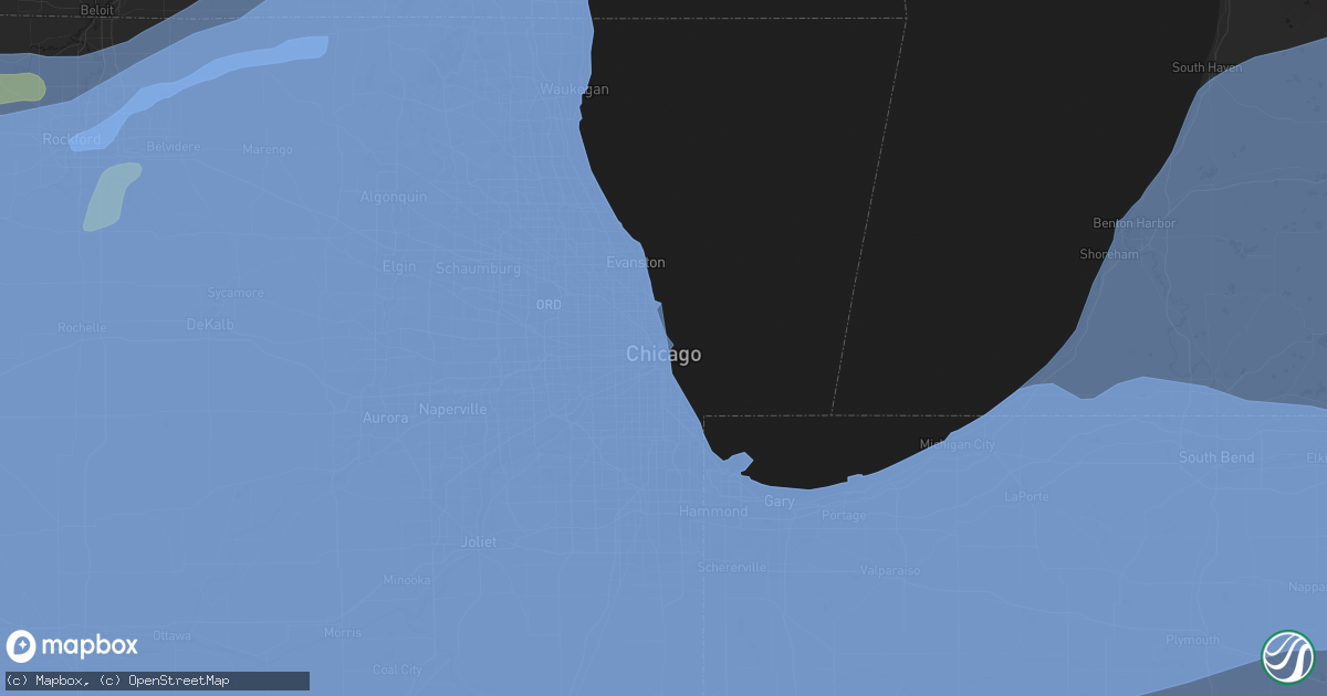
Hail Map in Chicago, IL on August 10, 2020
Get this storm
August 10 map
$229
one time, instant access
Download today. No call, no setup
Keep the $229
Bought the map and want the full workflow? Apply the entire $229 to a subscription within 7 days. None of it is wasted.
Every map, not just this one
This buys you this map. Subscription and you get every map we run, in the markets you choose from a few cities to whole states to nationwide. Plus real-time alerts the moment a storm fires.
Contact data
Name, contact info, occupancy, even credit band for addresses in the footprint. You go from where it hit to who to call.
Become the source they trust
Unlimited branding weather history reports on demand. You already have the documented answer ready for the property owner, and you are the one who showed up with it.
Property data and RoofTrace estimates
Pull up any address you have got, its value and the exact code rules for that jurisdiction, straight from One Click Code. Then RoofTrace estimates the squares, pitch, and roof value, priced the way you price.
Storm reports in Chicago, IL
Chicago, IL
| Date | Description |
|---|---|
| 08/10/20204:10 PM CDT | Tree blocking kezie blvd at logan blvd in logan square neighborhood of chicago. |
| 08/10/20204:03 PM CDT | Large tree snapped. Time estimated by radar. |
| 08/10/20204:02 PM CDT | Additional info on previous tornado report from 1 nnw west ridge - chicago. Additional video shared with nws shows tornado in rogers park neighborhood of chicago that e |
| 08/10/20204:00 PM CDT | Numerous reports of downed tree limbs across wrigleyville... Roscoe village... Logan square... And lincoln square. Time estimated by radar. |
| 08/10/20204:00 PM CDT | Possible structure damage near 18th and canalport avenue in chicago. |
| 08/10/20203:59 PM CDT | An nws damage survey confirmed an ef-1 tornado with estimated peak winds of 110 mph... Path length of 3 miles... And max width of 300 yards touched down near crawford a |
| 08/10/20203:57 PM CDT | Bricks knocked off top of building and trees downed. Time estimated by radar. |
| 08/10/20203:57 PM CDT | Reported at 2105 w eastwood dr... Chicago... Il. Large tree down and large branches broken out of other trees. |
| 08/10/20203:57 PM CDT | Measured by weatherbug station. |
| 08/10/20203:57 PM CDT | Midway asos peak gust. |
| 08/10/20203:57 PM CDT | Reports of a roof blown off a building north of addison and lake shore drive. |
| 08/10/20203:52 PM CDT | Small garage partially collapsed. Time estimated by radar. |
| 08/10/20203:50 PM CDT | Garage collapsed. Reported at nordica and roscoe. |
All States Impacted by Hail Map on August 10, 2020
All Cities Impacted by Hail Map on August 10, 2020
- Marienthal, KS
- Holcomb, KS
- Deerfield, KS
- Buffalo, OK
- Rosston, OK
- Englewood, KS
- Ashland, KS
- Cherryvale, KS
- Altamont, KS
- Parsons, KS
- Hazelton, KS
- Burlington, OK
- Waldron, KS
- Kiowa, KS
- Garden City, KS
- Scott City, KS
- Healy, KS
- Wright, KS
- Dodge City, KS
- Jetmore, KS
- Spearville, KS
- Hanston, KS
- La Crosse, KS
- Bison, KS
- McCracken, KS
- Brownell, KS
- Victoria, KS
- Hays, KS
- Ford, KS
- Minneola, KS
- Plains, KS
- Dorrance, KS
- Bunker Hill, KS
- Russell, KS
- Hudson, KS
- Raymond, KS
- Holyrood, KS
- Lorraine, KS
- Ellsworth, KS
- Conway Springs, KS
- Argonia, KS
- Waseca, MN
- New Richland, MN
- Pemberton, MN
- Mapleton, MN
- Janesville, MN
- Ellendale, MN
- Minnesota Lake, MN
- Waldorf, MN
- Centerview, MO
- Bates City, MO
- Otterville, MO
- Holden, MO
- Sedalia, MO
- Kingsville, MO
- Franklin, MO
- Higginsville, MO
- Warrensburg, MO
- Knob Noster, MO
- Boonville, MO
- Chilhowee, MO
- Concordia, MO
- Houstonia, MO
- Mayview, MO
- Pilot Grove, MO
- Nelson, MO
- Tipton, MO
- Smithton, MO
- Whiteman Air Force Base, MO
- Syracuse, MO
- Clarksburg, MO
- Blackburn, MO
- Odessa, MO
- Hughesville, MO
- Bunceton, MO
- Sweet Springs, MO
- Leeton, MO
- Blackwater, MO
- Marshall, MO
- La Monte, MO
- Mora, MO
- Cole Camp, MO
- Florence, MO
- Rush Hill, MO
- Thompson, MO
- Montgomery City, MO
- Wellsville, MO
- Mexico, MO
- Centralia, MO
- Laddonia, MO
- Vandalia, MO
- Middletown, MO
- Farber, MO
- Galt, MO
- Humphreys, MO
- Chillicothe, MO
- Chula, MO
- Trenton, MO
- Browning, MO
- Laredo, MO
- Jefferson City, MO
- Holts Summit, MO
- Bonnots Mill, MO
- Chamois, MO
- Tebbetts, MO
- Lake Saint Louis, MO
- Moscow Mills, MO
- Red Bud, IL
- Festus, MO
- Eolia, MO
- Prairie Du Rocher, IL
- Lenzburg, IL
- Eureka, MO
- Wildwood, MO
- Baldwin, IL
- Ashley, IL
- Herculaneum, MO
- Saint Libory, IL
- New Baden, IL
- Imperial, MO
- Hillsboro, MO
- Smithton, IL
- Troy, MO
- Ballwin, MO
- Arnold, MO
- Wentzville, MO
- Columbia, IL
- Mascoutah, IL
- East Carondelet, IL
- Old Monroe, MO
- Marissa, IL
- Fults, IL
- O'Fallon, MO
- Waterloo, IL
- Tamaroa, IL
- Belleville, IL
- Chesterfield, MO
- Millstadt, IL
- Winfield, MO
- Richview, IL
- Sparta, IL
- Oakdale, IL
- Okawville, IL
- Elsberry, MO
- High Ridge, MO
- Saint Peters, MO
- Nashville, IL
- Barnhart, MO
- House Springs, MO
- Defiance, MO
- Hecker, IL
- Coulterville, IL
- Addieville, IL
- Pevely, MO
- Hawk Point, MO
- Freeburg, IL
- Valley Park, MO
- Pinckneyville, IL
- Fenton, MO
- New Athens, IL
- Silex, MO
- Crystal City, MO
- Dupo, IL
- Valmeyer, IL
- Saint Charles, MO
- Tilden, IL
- Bowling Green, MO
- Du Bois, IL
- Evansville, IL
- Saint Louis, MO
- El Dorado Springs, MO
- Bolivar, MO
- Flemington, MO
- Polk, MO
- Freeport, IL
- Dakota, IL
- Lena, IL
- Kent, IL
- Stockton, IL
- Rock City, IL
- McConnell, IL
- Pearl City, IL
- Cedarville, IL
- Rockford, IL
- Winnebago, IL
- Rockton, IL
- Ridott, IL
- Davis, IL
- Pecatonica, IL
- Durand, IL
- Davis Junction, IL
- Belvidere, IL
- Cherry Valley, IL
- Monroe Center, IL
- Garden Prairie, IL
- Marengo, IL
- Morris, IL
- Lombard, IL
- Glen Ellyn, IL
- Villa Park, IL
- Oak Brook, IL
- Elmhurst, IL
- Stratford, TX
- Dalhart, TX
- Vega, TX
- Spearman, TX
- Gruver, TX
- Perryton, TX
- Hereford, TX
- Canyon, TX
- Dimmitt, TX
- Happy, TX
- Tulia, TX
- Adrian, TX
- Wildorado, TX
- Sudan, TX
- Borger, TX
- Skellytown, TX
- Panhandle, TX
- Pampa, TX
- Miami, TX
- Lohrville, IA
- Carroll, IA
- Odebolt, IA
- Glidden, IA
- Lanesboro, IA
- Auburn, IA
- Kiron, IA
- Battle Creek, IA
- Lake City, IA
- Breda, IA
- Wall Lake, IA
- Arthur, IA
- Ida Grove, IA
- Churdan, IA
- Vail, IA
- Charter Oak, IA
- Arion, IA
- Manilla, IA
- Manning, IA
- Ute, IA
- Dunlap, IA
- Westside, IA
- Dow City, IA
- Mapleton, IA
- Denison, IA
- Coon Rapids, IA
- Scranton, IA
- Jefferson, IA
- Cascade, IA
- Bernard, IA
- Parnell, IA
- Alexandria, IN
- Griffith, IN
- Zearing, IA
- Le Claire, IA
- New Buffalo, MI
- Reddick, IL
- Stillman Valley, IL
- Huxley, IA
- Maple Park, IL
- Wren, OH
- Kimmell, IN
- Princeville, IL
- Crescent City, IL
- Tampico, IL
- Soldier, IA
- Elmwood Park, IL
- Bristol, IL
- Loda, IL
- Slater, IA
- New Goshen, IN
- Forest City, IL
- Spencerville, IN
- Osceola, IN
- Tolono, IL
- Harlan, IA
- Carman, IL
- Macy, NE
- Yates City, IL
- Alvin, IL
- Newtown, IN
- Hills, IA
- Lawndale, IL
- Groveland, IL
- Grovertown, IN
- Lost Nation, IA
- Kewanna, IN
- Evergreen Park, IL
- Bloomingdale, IN
- Berkeley, IL
- Davenport, IA
- Lake View, IA
- Garwin, IA
- Caledonia, WI
- Irwin, IA
- University Park, IL
- Wayne, IL
- Springville, IA
- Morocco, IN
- Delavan, IL
- Homestead, IA
- Sheridan, IL
- Mooseheart, IL
- Franklin Grove, IL
- Creve Coeur, IL
- Mark Center, OH
- Batavia, IL
- Edgerton, OH
- Galien, MI
- Woodhull, IL
- Urbandale, IA
- Windfall, IN
- Round Lake, IL
- Emington, IL
- Saunemin, IL
- Pine Village, IN
- Magnolia, IA
- Russiaville, IN
- Worth, IL
- Aspinwall, IA
- Reinbeck, IA
- Grundy Center, IA
- Marne, IA
- Alamo, IN
- Cedar, IA
- Bartlett, IL
- Wapella, IL
- Chebanse, IL
- Hebron, IL
- Olds, IA
- Danville, IA
- Papineau, IL
- Stevensville, MI
- Ely, IA
- Independence, IA
- Stuart, IA
- Kenosha, WI
- Park Ridge, IL
- Spring Valley, IL
- Little York, IL
- Whitestown, IN
- Kalamazoo, MI
- Caledonia, IL
- Pleasant Prairie, WI
- Brookston, IN
- Grinnell, IA
- Williamsville, IL
- London Mills, IL
- Yeoman, IN
- Stone Park, IL
- Boswell, IN
- Walkerton, IN
- Lemont, IL
- Hudson, IA
- Cuba, IL
- Grand Ridge, IL
- Westpoint, IN
- Seneca, IL
- Thornton, IL
- Payne, OH
- Maywood, IL
- Fair Oaks, IN
- Great Lakes, IL
- Roberts, IL
- Veedersburg, IN
- Oswego, IL
- Crystal Lake, IL
- Staunton, IN
- Decatur, MI
- Grover Hill, OH
- Laura, IL
- Westchester, IL
- Jones, MI
- Clinton, WI
- Willshire, OH
- Marshalltown, IA
- Gladbrook, IA
- New Bremen, OH
- Kinsman, IL
- Emerson, IA
- Eldon, IA
- Palatine, IL
- Hanna City, IL
- New Windsor, IL
- Coloma, MI
- Gridley, IL
- Keswick, IA
- Manteno, IL
- Walnut, IL
- Marshall, IN
- Cambridge, IA
- Conroy, IA
- Spragueville, IA
- Kelley, IA
- Grand Junction, MI
- Muncie, IN
- Waterloo, NE
- Paxton, IL
- Mansfield, IL
- Lafayette, IN
- Manchester, IA
- Greencastle, IN
- Moscow, IA
- Crawfordsville, IA
- Morton Grove, IL
- Somonauk, IL
- Sherwood, OH
- Kalida, OH
- Clarence, IA
- Stanwood, IA
- North Sioux City, SD
- Monroe, IN
- Sheffield, IL
- Fowler, IN
- Constantine, MI
- Wilmette, IL
- Royal, IL
- Ferguson, IA
- Roachdale, IN
- Easton, IL
- Saint Joe, IN
- Taylor Ridge, IL
- Clemons, IA
- Riverside, IA
- River Grove, IL
- Coggon, IA
- Arlington Heights, IL
- Boone, IA
- Kirkville, IA
- Botkins, OH
- Emden, IL
- Shipshewana, IN
- Oakwood, IL
- Wanatah, IN
- Oneida, IL
- Yorkville, IL
- Solon, IA
- Cicero, IL
- Lexington, IL
- La Motte, IA
- Momence, IL
- Paragon, IN
- Craig, NE
- Monroe, IA
- Baroda, MI
- Mount Carroll, IL
- Altona, IL
- Buffalo Grove, IL
- Cary, IL
- Yutan, NE
- Bellevue, IA
- Gilson, IL
- Delta, IA
- Lima, OH
- Bourbon, IN
- Defiance, OH
- Verona, IL
- Panora, IA
- Minonk, IL
- Johnston, IA
- Eureka, IL
- Keota, IA
- Griswold, IA
- Rio, IL
- Cedar Rapids, IA
- Genoa, IL
- Capron, IL
- Lockridge, IA
- Arthur, IL
- Thomasboro, IL
- Osco, IL
- Serena, IL
- Hornick, IA
- Keithsburg, IL
- Colfax, IA
- Wilton, IA
- Fairfield, IA
- Harper, IA
- Council Bluffs, IA
- Lidderdale, IA
- Springfield, NE
- Fox Lake, IL
- Rippey, IA
- Dixon, IA
- New Haven, IN
- La Salle, IL
- Bouton, IA
- Chicago Heights, IL
- Arcola, IL
- Kokomo, IN
- Shelby, IN
- East Moline, IL
- Oxford, IA
- Wapello, IA
- Hometown, IL
- Waynetown, IN
- Bainbridge, IN
- Markle, IN
- Avilla, IN
- Genoa City, WI
- Pesotum, IL
- Elliott, IL
- Le Roy, IL
- Hayesville, IA
- Milford, IL
- Plano, IL
- Olin, IA
- Toulon, IL
- Homewood, IL
- Willowbrook, IL
- Mitchellville, IA
- Climax, MI
- Algonquin, IL
- Smithland, IA
- Buffalo, IL
- Durant, IA
- Danvers, IL
- Wakarusa, IN
- Bloomingdale, IL
- West Brooklyn, IL
- Tipton, IN
- Lovilia, IA
- Coatesville, IN
- Oakford, IL
- Andover, IL
- Maroa, IL
- Ludlow, IL
- McClelland, IA
- Toddville, IA
- Mount Auburn, IA
- Hooper, NE
- Piper City, IL
- Chesterton, IN
- Addison, IL
- La Place, IL
- Georgetown, IL
- Yale, IA
- Perrysville, IN
- New Bedford, IL
- Lane, IL
- Minooka, IL
- Preston, IA
- Arrowsmith, IL
- Columbus Junction, IA
- Pekin, IL
- Lawton, MI
- Barrington, IL
- Ladoga, IN
- Wataga, IL
- South Wilmington, IL
- New Ross, IN
- Mount Pleasant, IA
- North Aurora, IL
- Bremen, IN
- Dalzell, IL
- Larwill, IN
- East Galesburg, IL
- Blakesburg, IA
- New Troy, MI
- Van Wert, OH
- Newton, IA
- Goshen, IN
- Wellington, IL
- Hickory Hills, IL
- Canton, IL
- Mount Pulaski, IL
- Monmouth, IL
- Saint Joseph, MI
- Pleasant Valley, IA
- Bettendorf, IA
- Lacona, IA
- Whitten, IA
- Park Forest, IL
- Winthrop Harbor, IL
- Hoopeston, IL
- North English, IA
- Lovington, IL
- Springfield, IL
- Randall, IA
- Russellville, IN
- Spencerville, OH
- Monterey, IN
- Lowden, IA
- Rensselaer, IN
- Kellogg, IA
- Metcalf, IL
- White Heath, IL
- Newhall, IA
- Loves Park, IL
- Lincolnwood, IL
- Des Plaines, IL
- Milmine, IL
- Fairview, IL
- Hillside, IL
- Allegan, MI
- Rossville, IL
- Oak Lawn, IL
- Hindsboro, IL
- Carlock, IL
- Melrose Park, IL
- Saint Anne, IL
- Elliott, IA
- Mahomet, IL
- North Liberty, IA
- Erie, IL
- Ira, IA
- Avoca, IA
- Kilbourne, IL
- Underwood, IA
- Waynesville, IL
- Bensenville, IL
- Marion, IA
- Dana, IN
- Cutler, IN
- Brazil, IN
- Washington, IA
- Brook, IN
- Linden, IA
- Beverly Shores, IN
- West Chester, IA
- Summit Argo, IL
- Indianola, IA
- Clinton, IN
- Pella, IA
- Bancroft, NE
- Guernsey, IA
- Ackworth, IA
- Westfield, IN
- Wilmot, WI
- Winfield, IA
- Emerson, NE
- Blue Island, IL
- Robbins, IL
- Gifford, IL
- Dubuque, IA
- Camargo, IL
- Naperville, IL
- Kingsford Heights, IN
- Hubbard, NE
- Franklin Park, IL
- Cloverdale, IN
- Sodus, MI
- Waveland, IN
- Elkhart, IN
- Bloomington, IL
- Sac City, IA
- Churubusco, IN
- Wilmington, IL
- Rochelle, IL
- Magnolia, IL
- Milo, IA
- Winfield, IL
- Glasford, IL
- Dundee, IL
- Martinsburg, IA
- Tallula, IL
- Little Sioux, IA
- Donahue, IA
- Farnhamville, IA
- Hartsburg, IL
- Dixon, IL
- Lowpoint, IL
- Big Rock, IL
- Dekalb, IL
- Venedocia, OH
- Tekamah, NE
- Zionsville, IN
- Story City, IA
- Craigville, IN
- Letts, IA
- Winnebago, NE
- Central City, IA
- Cabery, IL
- Oquawka, IL
- West Chicago, IL
- West Des Moines, IA
- Cushing, IA
- Bennett, IA
- Wheatfield, IN
- Battle Creek, MI
- Putnamville, IN
- Palos Heights, IL
- Brandon, IA
- Chicago, IL
- Bagley, IA
- Louisville, NE
- Deep River, IA
- Bondville, IL
- Clarks Hill, IN
- Exira, IA
- Glenview, IL
- Joy, IL
- Scott, OH
- Danbury, IA
- Posen, IL
- Norwalk, IA
- Bismarck, IL
- Treynor, IA
- Bringhurst, IN
- Berrien Center, MI
- De Witt, IA
- Danville, IN
- Polk City, IA
- Sully, IA
- Lone Tree, IA
- Newman, IL
- Dover, IL
- Raymond, IA
- Olympia Fields, IL
- Evansdale, IA
- Brooklyn, IN
- Gilman, IL
- Gibson City, IL
- Fishers, IN
- Mossville, IL
- Persia, IA
- Clutier, IA
- Chillicothe, IA
- Rolling Prairie, IN
- Dallas Center, IA
- Oakwood, OH
- Lincolnshire, IL
- Waterford, WI
- Urbana, IA
- Chenoa, IL
- Sibley, IL
- Center Junction, IA
- Traer, IA
- Dedham, IA
- Garrett, IN
- Hickory Corners, MI
- Bridgman, MI
- Bonfield, IL
- Fremont, IA
- Trafalgar, IN
- Colfax, IN
- Eldridge, IA
- McCallsburg, IA
- La Rose, IL
- Knox, IN
- Elk Horn, IA
- Grayslake, IL
- Sadorus, IL
- Rhodes, IA
- Lynnville, IA
- Paw Paw, MI
- Minburn, IA
- Lakeville, IN
- Hamilton, IA
- Brimfield, IL
- Oakland, IL
- Oglesby, IL
- Kingston, IL
- Dana, IL
- Burlington, IA
- Searsboro, IA
- Mineral, IL
- Wheatland, IA
- Seaton, IL
- Clifton, IL
- Gosport, IN
- Huntley, IL
- Havana, IL
- Ligonier, IN
- Conrad, IA
- Young America, IN
- Henderson, IA
- Congerville, IL
- Onslow, IA
- Hedrick, IA
- Midlothian, IL
- Wood Dale, IL
- Crestwood, IL
- Spring Grove, IL
- Glenwood, IL
- Steger, IL
- Wenona, IL
- Trevor, WI
- Lawrence, MI
- Braceville, IL
- Philo, IL
- Hanover, IL
- Mount Morris, IL
- Riverside, IL
- Columbia City, IN
- Illinois City, IL
- Hennepin, IL
- Lapel, IN
- Universal, IN
- Dewey, IL
- Greentown, IN
- Hooppole, IL
- Winamac, IN
- Broadview, IL
- Adel, IA
- Saint Charles, IL
- Daleville, IN
- Worthington, IA
- Lebanon, IN
- Hinckley, IL
- Tuscola, IL
- Hazel Crest, IL
- Watseka, IL
- Carson, IA
- Smithshire, IL
- Oakland, IA
- Cisco, IL
- Climbing Hill, IA
- Princeton, IA
- Cassopolis, MI
- Middletown, IL
- Princeton, IL
- Sioux City, IA
- Michigan City, IN
- Red Oak, IA
- Catlin, IL
- Watkins, IA
- Brighton, IA
- Tracy, IA
- Williamsport, IN
- Schneider, IN
- Saint John, IN
- Speer, IL
- Bristol, IN
- Sloan, IA
- Rockford, OH
- Bondurant, IA
- Hamlet, IN
- Cissna Park, IL
- Prole, IA
- Silver Lake, WI
- Cantrall, IL
- Decatur, NE
- Gobles, MI
- Adair, IA
- Rose Hill, IA
- Middletown, IA
- Middlebury, IN
- Logan, IA
- Atlantic, IA
- Fithian, IL
- Northbrook, IL
- Hopkinton, IA
- Roselle, IL
- Pleasantville, IA
- Pilot Mound, IA
- Forest Park, IL
- Hobart, IN
- Welton, IA
- Reelsville, IN
- Pender, NE
- Armstrong, IL
- Hancock, IA
- Glencoe, IL
- Claypool, IN
- Plainfield, IN
- Tama, IA
- Richton Park, IL
- Fisher, IL
- Crown Point, IN
- Dewitt, IL
- Elmwood, IL
- De Land, IL
- Francesville, IN
- Reasnor, IA
- Highland, IN
- Crawfordsville, IN
- Normal, IL
- Macy, IN
- Panama, IA
- Buck Creek, IN
- Glenwood, IA
- Oakland, NE
- Somers, IA
- Defiance, IA
- Elizabeth, IL
- Vandalia, MI
- Buda, IL
- Farmington, IL
- Muscatine, IA
- Joliet, IL
- Wyanet, IL
- Long Grove, IA
- Portsmouth, IA
- Albion, IA
- Villa Grove, IL
- Callender, IA
- Epworth, IA
- Anderson, IN
- Orland Park, IL
- Warrensburg, IL
- Benson, IL
- Campus, IL
- Montezuma, IA
- Anchor, IL
- South Bend, IN
- Mulberry, IN
- Lewis, IA
- Sawyer, MI
- Esmond, IL
- Bowling Green, IN
- Riverton, IL
- Millington, IL
- Harcourt, IA
- Wakefield, NE
- Millersburg, IN
- Streator, IL
- Carbon Cliff, IL
- Hinton, IA
- Pittsboro, IN
- Silver Lake, IN
- Garden City, IA
- Cedar Falls, IA
- Wauconda, IL
- Luzerne, IA
- Atkinson, IL
- Kewanee, IL
- Laketon, IN
- Port Byron, IL
- Terre Haute, IN
- Island Lake, IL
- Dakota City, NE
- Shellsburg, IA
- South Bend, NE
- Ellisville, IL
- Templeton, IN
- Schleswig, IA
- Nappanee, IN
- Oregon, IL
- Huntertown, IN
- Cumming, IA
- Riley, IN
- Thurston, NE
- Donovan, IL
- Waukegan, IL
- Advance, IN
- Runnells, IA
- Radcliffe, IA
- Fox River Grove, IL
- Andrew, IA
- Jesup, IA
- Galveston, IN
- Waukee, IA
- Mason City, IL
- Seatonville, IL
- Sparland, IL
- Kempton, IN
- Danville, IL
- Teeds Grove, IA
- Westmont, IL
- Scotts, MI
- Bryan, OH
- Tiffin, IA
- Mokena, IL
- Eldora, IA
- Riverdale, IL
- Wayland, IA
- Portage, IN
- Bryant, IL
- Elburn, IL
- Baileyville, IL
- Richland, IA
- Berwyn, IL
- Correctionville, IA
- Ralston, IA
- Grant Park, IL
- Moline, IL
- Continental, OH
- East Peoria, IL
- Peoria, IL
- Booneville, IA
- Thorntown, IN
- Liberty Mills, IN
- Westville, IN
- Bayard, IA
- Walthill, NE
- Penfield, IL
- Ogden, IL
- Andalusia, IL
- Rantoul, IL
- Rochester, IN
- South Elgin, IL
- Hopedale, IL
- Kendallville, IN
- Avon, IL
- Victoria, IL
- Mount Ayr, IN
- Haverhill, IA
- Frankton, IN
- Papillion, NE
- Peoria Heights, IL
- Silvis, IL
- Wheaton, IL
- Gaston, IN
- Herman, NE
- Troy Grove, IL
- Varna, IL
- Eau Claire, MI
- Heyworth, IL
- Union Grove, WI
- Edelstein, IL
- Battle Ground, IN
- Coal Valley, IL
- Kingsley, IA
- Wadsworth, IL
- Pleasant Hill, IA
- Grimes, IA
- Noblesville, IN
- Saint Anthony, IA
- Woodridge, IL
- Butler, IN
- Cropsey, IL
- Atlanta, IL
- Bourbonnais, IL
- Columbus, IN
- New Holland, IL
- Brookfield, IL
- Gretna, NE
- Elkhart, IA
- Oskaloosa, IA
- West Point, NE
- Cory, IN
- Lake In The Hills, IL
- Savoy, IL
- Union, IL
- New Knoxville, OH
- Cornell, IL
- La Fayette, IL
- Rutland, IL
- Delavan, WI
- Shorewood, IL
- Elkhorn, WI
- Earlham, IA
- Romney, IN
- Albia, IA
- Athens, IL
- Richland, MI
- West Lafayette, IN
- Lake Station, IN
- Union, MI
- Ryan, IA
- Holcomb, IL
- Ambia, IN
- Homer Glen, IL
- Leonore, IL
- Decatur, IL
- Washburn, IL
- Ohio City, OH
- Rowley, IA
- Schererville, IN
- Leaf River, IL
- Lake Villa, IL
- Norris, IL
- Swayzee, IN
- Bridgeton, IN
- Hillsdale, IN
- Flora, IN
- Morning Sun, IA
- Baldwin, IA
- Peru, IL
- Saybrook, IL
- Maquon, IL
- Rossville, IN
- Muncie, IL
- Delmar, IA
- Melrose, OH
- Highwood, IL
- Martinton, IL
- Cedar Point, IL
- West Liberty, IA
- Boxholm, IA
- Anamosa, IA
- Ricketts, IA
- Union Mills, IN
- Summitville, IN
- Flossmoor, IL
- Webster, IA
- Compton, IL
- Etna Green, IN
- Buffalo, IA
- Rockville, IN
- Fairmount, IL
- Lisle, IL
- Ames, IA
- Golf, IL
- Blairstown, IA
- Jamaica, IA
- Rockwell City, IA
- Avon, IN
- Yoder, IN
- Blencoe, IA
- Carbon, IN
- Montezuma, IN
- Buckingham, IL
- Rankin, IL
- Leo, IN
- Niantic, IL
- Woodward, IA
- Bellevue, NE
- Leighton, IA
- Ringwood, IL
- Albion, IN
- Kouts, IN
- Chillicothe, IL
- Morrison, IL
- Libertyville, IA
- Amboy, IL
- Abingdon, IL
- Carlisle, IA
- La Grange, IL
- Dawson, IA
- Buckley, IL
- Kenilworth, IL
- Polo, IL
- Columbus City, IA
- Anthon, IA
- Otsego, MI
- Hoffman Estates, IL
- New Lenox, IL
- Oak Park, IL
- Country Club Hills, IL
- Cecil, OH
- Sperry, IA
- Manlius, IL
- Jamestown, IN
- Dyersville, IA
- Edwards, IL
- Gilbert, IA
- Lanark, IL
- South Beloit, IL
- University Park, IA
- Burket, IN
- Prospect Heights, IL
- Ney, OH
- Forsyth, IL
- Audubon, IA
- Buckland, OH
- Oxford Junction, IA
- North Chicago, IL
- Trivoli, IL
- Fulton, MI
- Rosalie, NE
- Darien, IL
- Hume, IL
- Conesville, IA
- Cortland, IL
- Berwick, IL
- Akron, IN
- Haviland, OH
- Mundelein, IL
- Poplar Grove, IL
- Collins, IA
- Lake Bluff, IL
- Dike, IA
- Hanna, IN
- Harvard, IL
- Whiting, IA
- Wheeling, IL
- Langworthy, IA
- Sherrard, IL
- Hamilton, IN
- Weldon, IL
- Chestnut, IL
- Valley, NE
- Alleman, IA
- East Chicago, IN
- Buchanan, MI
- Colfax, IL
- Knightsville, IN
- Millbrook, IL
- Clive, IA
- Otterbein, IN
- Carmel, IN
- Goodfield, IL
- Brayton, IA
- Neponset, IL
- South Holland, IL
- Grabill, IN
- Topeka, IN
- Elwood, IN
- Monon, IN
- Dowagiac, MI
- Waterloo, IA
- Ladd, IL
- Ossian, IN
- Hammond, IN
- Moorhead, IA
- Wellman, IA
- Dolton, IL
- Media, IL
- Missouri Valley, IA
- North Liberty, IN
- Kempton, IL
- Melbourne, IA
- Charlotte, IA
- White Pigeon, MI
- Ophiem, IL
- South English, IA
- Atlanta, IN
- Offutt Afb, NE
- Waterman, IL
- Swan, IA
- Onarga, IL
- Chelsea, IA
- Deer Grove, IL
- Linden, IN
- Maxwell, IA
- Lake Zurich, IL
- Monee, IL
- Henry, IL
- Itasca, IL
- Mentone, IN
- Hillsboro, IN
- Corunna, IN
- New Paris, IN
- Columbia, IA
- Casey, IA
- Shirley, IL
- Hampshire, IL
- Wonder Lake, IL
- Ashley, IN
- Stanhope, IA
- Union Hill, IL
- Paris, IL
- La Porte, IN
- Greenview, IL
- State Line, IN
- Beech Grove, IN
- Bennington, NE
- Saint Augustine, IL
- Kirkman, IA
- Pierceton, IN
- Roanoke, IL
- Zanesville, IN
- Henderson, IL
- Brocton, IL
- Milan, IL
- Guthrie Center, IA
- Wawaka, IN
- Fulton, IL
- New Richmond, IN
- Galva, IL
- Ollie, IA
- Paton, IA
- Crest Hill, IL
- Harwood Heights, IL
- Minster, OH
- Bargersville, IN
- Clare, IL
- North Manchester, IN
- La Crosse, IN
- Quasqueton, IA
- Decatur, IN
- Montour, IA
- Kirkland, IL
- Aledo, IL
- Union, IA
- Plainfield, IL
- Schaumburg, IL
- Winona Lake, IN
- Downers Grove, IL
- Marseilles, IL
- Ellsworth, IL
- Lyons, IL
- Minier, IL
- McCausland, IA
- Bridgeview, IL
- Carpentersville, IL
- Morrison, IA
- Roanoke, IN
- Packwood, IA
- Killduff, IA
- Cameron, IL
- Matherville, IL
- Calamus, IA
- Luther, IA
- Morley, IA
- Huntington, IN
- Rosedale, IN
- Convoy, OH
- Bloomingdale, MI
- Springfield, WI
- Illiopolis, IL
- Pleasant Plains, IL
- Batavia, IA
- Greenwood, IN
- Arcola, IN
- Whiting, IN
- Putnam, IL
- Fort Jennings, OH
- Gardner, IL
- Atwood, IL
- Dunlap, IL
- Hubbard, IA
- Niles, IL
- Zion, IL
- Saint Marys, OH
- Rolling Meadows, IL
- Coralville, IA
- Dana, IA
- Brownsburg, IN
- Henning, IL
- Peotone, IL
- Odell, IL
- Franklin, IN
- Wedron, IL
- West Newton, IN
- Ladora, IA
- Zwingle, IA
- Crescent, IA
- Spencer, IN
- Elwood, IL
- North Henderson, IL
- Vining, IA
- Metamora, IL
- Prairie City, IA
- Oakville, IA
- Castana, IA
- Mattawan, MI
- Broadlands, IL
- Mount Union, IA
- Harlan, IN
- Fort Wayne, IN
- Paw Paw, IL
- Martinsville, IN
- Lincoln, IA
- Sabula, IA
- Bradford, IL
- Lockport, IL
- Ellsworth, IA
- Roland, IA
- Bunker Hill, IN
- Toledo, IA
- Dawson, IL
- Monmouth, IA
- Malden, IL
- Royal Center, IN
- Granger, IN
- Fort Calhoun, NE
- Plainwell, MI
- Covert, MI
- Victor, IA
- Cooksville, IL
- Lostant, IL
- Homer, NE
- Indianapolis, IN
- Stronghurst, IL
- Munster, IN
- Moorland, IA
- Harbert, MI
- Oxford, IN
- Justice, IL
- Alburnett, IA
- Iowa City, IA
- Boone Grove, IN
- Swisher, IA
- Laurel, IA
- Sterling, IL
- Gladstone, IL
- Amana, IA
- Fontana, WI
- Three Oaks, MI
- Melvin, IL
- Chicago Ridge, IL
- State Center, IA
- Cherry, IL
- Latham, IL
- Towanda, IL
- Champaign, IL
- Beaverville, IL
- Laotto, IN
- Libertyville, IL
- Burnettsville, IN
- Auburn, IN
- Hillsdale, IL
- Stratford, IA
- South Whitley, IN
- Bellflower, IL
- New Market, IN
- Sturtevant, WI
- Belle Plaine, IA
- Shabbona, IL
- Shannon, IL
- Fenton, IL
- Glendale Heights, IL
- Walker, IA
- Markham, IL
- Deloit, IA
- Gilberts, IL
- Lytton, IA
- Wyoming, IL
- Delhi, IA
- Urbana, IL
- Byron, IL
- New Boston, IL
- Yarmouth, IA
- Elgin, IL
- Lacon, IL
- Lake Village, IN
- Granville, IL
- Warsaw, IN
- Buffalo, IN
- Essex, IL
- Tremont, IL
- Graymont, IL
- Middle Amana, IA
- Rodney, IA
- Ankeny, IA
- San Jose, IL
- Halbur, IA
- Lake Geneva, WI
- Colona, IL
- Eldena, IL
- Lake Forest, IL
- Braidwood, IL
- Hammond, IL
- Kenney, IL
- Ingleside, IL
- Walnut, IA
- Alexis, IL
- East Leroy, MI
- Collison, IL
- Walworth, WI
- Highland Park, IL
- Earlville, IA
- Syracuse, IN
- Frankfort, IN
- Gary, IN
- Arcadia, IN
- Calumet City, IL
- Idaville, IN
- Sergeant Bluff, IA
- Liscomb, IA
- Berwick, IA
- Alsip, IL
- Logansport, IN
- Van Orin, IL
- Woodbine, IA
- Walford, IA
- Brooklyn, IA
- Martelle, IA
- Tipton, IA
- Arlington, IL
- Sheridan, IN
- Leesburg, IN
- Monticello, IA
- Kirklin, IN
- South Haven, MI
- Lee, IL
- Kalona, IA
- Danforth, IL
- Petersburg, IL
- Altoona, IA
- Bryant, IA
- Manito, IL
- Clinton, IL
- Hoagland, IN
- Hicksville, OH
- Elkhart, IL
- Mapleton, IL
- Ora, IN
- Sidney, IL
- Vicksburg, MI
- Romeoville, IL
- Roseville, IL
- Lawton, IA
- Walton, IN
- Fruitland, IA
- Remington, IN
- Hines, IL
- Vernon Hills, IL
- Argos, IN
- Sandwich, IL
- Bolingbrook, IL
- Woodstock, IL
- Murdock, IL
- Mackinaw, IL
- Mingo, IA
- Ridge Farm, IL
- Deerfield, IL
- Delphos, OH
- Buckingham, IA
- Mount Vernon, IA
- Holstein, IA
- Westphalia, IA
- Orion, IL
- Kansasville, WI
- Coal City, IL
- Athens, MI
- Milledgeville, IL
- Farmer City, IL
- Viola, IL
- Galesburg, IL
- Jolley, IA
- Ottawa, OH
- Kankakee, IL
- Redmon, IL
- Attica, IN
- Stockton, IA
- Montgomery, IL
- Cedar Lake, IN
- Wyoming, IA
- Deer Creek, IL
- Dayton, IN
- Richmond, IL
- Triumph, IL
- Gray, IA
- Nichols, IA
- Monrovia, IN
- Farley, IA
- Bristol, WI
- Shelby, IA
- Hinsdale, IL
- Paulding, OH
- Waterloo, IN
- Milford, IN
- Warrenville, IL
- Antioch, IL
- Agency, IA
- Valparaiso, IN
- Burlington, IL
- Mendon, OH
- Berrien Springs, MI
- Frankfort, IL
- Gibson, IA
- Vermilion, IL
- Lisbon, IA
- Schoolcraft, MI
- Lincoln, IL
- Cloverdale, OH
- Elkhorn, NE
- Hebron, IN
- South Pekin, IL
- Beaver, IA
- Matteson, IL
- Bellwood, IL
- Delphi, IN
- Woosung, IL
- Aurora, IL
- Portage, MI
- Blue Grass, IA
- Racine, WI
- Covington, IN
- Boys Town, NE
- Stockland, IL
- Van Meter, IA
- Burlington, WI
- Goodland, IN
- Dahinda, IL
- Granger, IA
- Kentland, IN
- Silver City, IA
- Atkins, IA
- Depue, IL
- Hamlin, IA
- New Liberty, IA
- Williams Bay, WI
- Malcom, IA
- Blackstone, IL
- Thayer, IN
- Redfield, IA
- Sugar Grove, IL
- Macedonia, IA
- Tiskilwa, IL
- Tippecanoe, IN
- Camden, IN
- Saint David, IL
- Geneseo, IL
- Melcher Dallas, IA
- Wiota, IA
- Dysart, IA
- Bradley, IL
- Thomson, IL
- West Branch, IA
- Williamsfield, IL
- Sheldon, IL
- Bussey, IA
- Kingston Mines, IL
- Lyndon, IL
- Poland, IN
- West Terre Haute, IN
- Lizton, IN
- Downs, IL
- Potomac, IL
- Bement, IL
- Lynn Center, IL
- Cicero, IN
- Nineveh, IN
- Beacon, IA
- North Judson, IN
- Allerton, IL
- Pendleton, IN
- Nevada, IA
- Miles, IA
- Chadwick, IL
- Uniondale, IN
- Oto, IA
- Harmon, IL
- Hartford, MI
- West Lebanon, IN
- Delton, MI
- Saint Joseph, IL
- Masonville, IA
- Beason, IL
- Cullom, IL
- Norway, IA
- Demotte, IN
- Perry, IA
- Carter Lake, IA
- Franksville, WI
- Jonesboro, IN
- Tonica, IL
- Cromwell, IN
- Cordova, IL
- Ransom, IL
- Uehling, NE
- Gilbertville, IA
- Kansas, IL
- Center Point, IA
- Gowrie, IA
- Mendon, MI
- Benton Harbor, MI
- South Sioux City, NE
- Alpha, IL
- Watervliet, MI
- Salix, IA
- German Valley, IL
- Marengo, IA
- Foosland, IL
- Barnes City, IA
- Hartford, IA
- Monticello, IN
- Fairbury, IL
- Medinah, IL
- Mill Creek, IN
- Crete, IL
- Otley, IA
- Taylorsville, IN
- Knoxville, IA
- Annawan, IL
- Anna, OH
- Millersburg, IA
- Westville, IL
- Biggsville, IL
- Standard, IL
- Ashton, IL
- Lansing, IL
- Aroma Park, IL
- Grand Junction, IA
- Sublette, IL
- Twin Lakes, WI
- Chrisman, IL
- Beecher, IL
- Rock Falls, IL
- Morton, IL
- Mooresville, IN
- La Vista, NE
- Malta, IL
- Hanover Park, IL
- Bangor, MI
- Earl Park, IN
- Darlington, IN
- Maquoketa, IA
- Mchenry, IL
- Monroeville, IN
- Carol Stream, IL
- New Sharon, IA
- Kirkwood, IL
- Bluffton, IN
- Camanche, IA
- Lucerne, IN
- Chatsworth, IL
- Longview, IL
- Monticello, IL
- Eddyville, IA
- Green Valley, IL
- Quincy, IN
- Utica, IL
- Thawville, IL
- Grand Mound, IA
- Grandview, IA
- Rapids City, IL
- Pontiac, IL
- Oak Forest, IL
- Ogden, IA
- Liverpool, IL
- Honey Creek, IA
- Schiller Park, IL
- Skokie, IL
- Seymour, IL
- El Paso, IL
- Vinton, IA
- Van Horne, IA
- Roscoe, IL
- Early, IA
- Evanston, IL
- Edwardsburg, MI
- Garrison, IA
- Savanna, IL
- Columbus Grove, OH
- Galesburg, MI
- Tilton, IL
- Lakeside, MI
- Notre Dame, IN
- Ottoville, OH
- Marcellus, MI
- Palos Hills, IL
- Winthrop, IA
- Le Grand, IA
- Pembroke Township, IL
- Niles, MI
- Minden, IA
- Morgantown, IN
- Yorktown, IN
- Willow Springs, IL
- New Carlisle, IN
- Mount Prospect, IL
- Salem, WI
- McLean, IL
- Medaryville, IN
- What Cheer, IA
- Michigantown, IN
- Steward, IL
- Cayuga, IN
- Winnetka, IL
- Sherman, IL
- Rock Island, IL
- Topeka, IL
- River Forest, IL
- Colo, IA
- Prairieburg, IA
- Stilesville, IN
- Sidney, OH
- Culver, IN
- Mendota, IL
- Keystone, IA
- Montpelier, IA
- Homer, IL
- Long Point, IL
- Chana, IL
- Middletown, IN
- La Porte City, IA
- Beaman, IA
- Hartwick, IA
- McNabb, IL
- Clayton, IN
- Manhattan, IL
- Mediapolis, IA
- Baxter, IA
- Forreston, IL
- Sheldahl, IA
- Western Springs, IL
- Mecca, IN
- Kimballton, IA
- Earlville, IL
- Ottawa, IL
- Ashkum, IL
- Ainsworth, IA
- Ohio, IL
- Lewistown, IL
- Des Moines, IA
- North Salem, IN
- Harmony, IN
- Menlo, IA
- Fortville, IN
- Wapakoneta, OH
- Lyons, NE
- Dyer, IN
- Sidell, IL
- Fairfax, IA
- Indianola, IL
- Madrid, IA
- Channahon, IL
- Palo, IA
- Wolcott, IN
- Onawa, IA
- Burlington, IN
- Union Pier, MI
- Atwood, IN
- Pierson, IA
- Mazon, IL
- Mineola, IA
- Flanagan, IL
- Ceresco, MI
- Ivesdale, IL
- Cerro Gordo, IL
- La Moille, IL
- Palos Park, IL
- Camby, IN
- Lowell, IN
- Knoxville, IL
- Lindenwood, IL
- Forrest, IL
- New London, IA
- Anita, IA
- Wingate, IN
- Latty, OH
- Fairmount, IN
- Fillmore, IN
- Augusta, MI
- Blair, NE
- Galena, IL
- Leland, IL
- West Burlington, IA
- Templeton, IA
- Plymouth, IN
- Centerpoint, IN
- Atalissa, IA
- Windsor Heights, IA
- La Grange Park, IL
- Geneva, IL
- Harvey, IL
- Merrillville, IN
- Moville, IA
- Bureau, IL
- Goose Lake, IA
- Secor, IL
- Elk Grove Village, IL
- Star City, IN
- Bronson, IA
- Omaha, NE
- Ancona, IL
- Manson, IA
- Sigourney, IA
- Elberon, IA
- Middle Point, OH
- Wasco, IL
- Earling, IA
- Sharpsville, IN
- Gurnee, IL
- Neola, IA
- Celina, OH
- Pisgah, IA
- Jewell, IA
- Mechanicsville, IA
- Mishawaka, IN
- San Pierre, IN
- Mark, IL
- Clarendon Hills, IL
- Reynolds, IL
- Ottumwa, IA
- Iroquois, IL
- Walcott, IA
- Arcadia, IA
- Mondamin, IA
- Forest, IN
- Edinburgh, IN
- Toluca, IL
- Newark, IL
- Stanford, IL
- Tinley Park, IL
- Three Rivers, MI
- Hiawatha, IA
- Albany, IL
- Hampton, IL
- Roann, IN
- Dwight, IL
- Low Moor, IA
- Robins, IA
- Streamwood, IL
- Gerlaw, IL
- South Amana, IA
- Mellott, IN
- Washington, IL
- Harvey, IA
- Chalmers, IN
- Goldsmith, IN
- Modale, IA
- Argenta, IL
- Sycamore, IL
- Prophetstown, IL
- Cambridge, IL
- Williamsburg, IA
- North Webster, IN
- Oreana, IL
- Peosta, IA
- Gilman, IA
- Woodburn, IN
- Antwerp, OH
- Sharon, WI
- Bishop Hill, IL
- Machesney Park, IL
- Clinton, IA
- Strawn, IL
- Ashland, NE
- Kingman, IN
- Burbank, IL
- Dayton, IA
- Armington, IL
- New Providence, IA
- Hudson, IL
- Herscher, IL
- Salem, IN
- Whigham, GA
- Pelham, GA
- Macon, GA
- Gordon, GA
- Warm Springs, GA
- Pine Mountain, GA
- Hamilton, GA
- Shiloh, GA
- Ware, MA
- Pell City, AL
- Fish Creek, WI
- Ephraim, WI
- Sister Bay, WI
- Baileys Harbor, WI
- Wynona, OK
- Burbank, OK
- Pawhuska, OK
- Barnsdall, OK
- Skiatook, OK
- Bartlesville, OK
- Shattuck, OK
- Woodward, OK
- Sharon, OK
- Fargo, OK
- Arnett, OK
- Gage, OK
- Taloga, OK
- Vici, OK
- Camargo, OK
- Sentinel, OK
- Carter, OK
- Dill City, OK
- Kingfisher, OK
- Hobart, OK
- Lone Wolf, OK
- Liberty, KS
- Edna, KS
- Bartlett, KS
- Chetopa, KS
- Galena, KS
- Quapaw, OK
- Mound Valley, KS
- Columbus, KS
- Coffeyville, KS
- Riverton, KS
- Picher, OK
- Baxter Springs, KS
- Oswego, KS
- Miami, OK
- Treece, KS
- Arkansas City, KS
- Winfield, KS
- Walker, KS
- Stafford, KS
- Turon, KS
- Arlington, KS
- Pretty Prairie, KS
- Kingman, KS
- Sylvia, KS
- Dry Branch, GA
- Silverton, TX
- Turkey, TX
- Quitaque, TX
- Braman, OK
- Medford, OK
- Freedom, OK
- Gate, OK
- Forgan, OK
- Kaw City, OK
- Shidler, OK
- Nevada, MO
- Walker, MO
- Babcock, WI
- Black River Falls, WI
- Necedah, WI
- Pittsville, WI
- Nekoosa, WI
- Warrens, WI
- Patch Grove, WI
- Potosi, WI
- Livingston, WI
- Bloomington, WI
- Mineral Point, WI
- Argyle, WI
- Gratiot, WI
- Bagley, WI
- Blanchardville, WI
- Monroe, WI
- Lancaster, WI
- Belmont, WI
- Cassville, WI
- Prairie Du Chien, WI
- Woodford, WI
- Shullsburg, WI
- Brodhead, WI
- Guttenberg, IA
- Glen Haven, WI
- Fennimore, WI
- Darlington, WI
- Mount Hope, WI
- Juda, WI
- South Wayne, WI
- Beloit, WI
- Garnavillo, IA
- Platteville, WI
- Cuba City, WI
- Browntown, WI
- Stitzer, WI
- Rewey, WI
- Posen, MI
- Talladega, AL
- Stinnett, TX
- Sunray, TX
- Amorita, OK
- McIntyre, GA
- Laverne, OK
- Saint Olaf, IA
- McGregor, IA
- Lawler, IA
- Elma, IA
- Cresco, IA
- Fowler, CO
- Salem, MO
- Lupton, MI
- Rose City, MI
- Greensburg, KS
- Ness City, KS
- Rockford, IA
- Dougherty, IA
- Rockwell, IA
- Harwood, MO
- Dalton, GA
- Winslow, IL
- Greenville, IL
- Pocahontas, IL
- Dixon Springs, TN
- Pleasant Shade, TN
- Hillsboro, IL
- Coffeen, IL
- Oconee, IL
- Nokomis, IL
- Pana, IL
- Friendship, WI
- Arkdale, WI
- Fort Stockton, TX
- Fayette, AL
- Pierce, NE
- Manitowoc, WI
- Lachine, MI
- Hillman, MI
- Winside, NE
- Hoskins, NE
- Norfolk, NE
- Carthage, TN
- Gainesboro, TN
- Adair, IL
- Table Grove, IL
- Hardyville, KY
- Munfordville, KY
- Wallace, MI
- Menominee, MI
- Dumas, TX
- Liebenthal, KS
- Augusta, GA
- Stonington, IL
- Blue Mound, IL
- Presque Isle, MI
- Rogers City, MI
- Daggett, MI
- Carney, MI
- Clermont, FL
- Cadillac, MI
- Rock, MI
- Hephzibah, GA
- New Hampton, IA
- Boise City, OK
- Murfreesboro, TN
- Chestnut Mound, TN
- Elmwood, TN
- Sullivan, MO
- Lakewood, IL
- Boone, CO
- Calmar, IA
- Waucoma, IA
- Hermansville, MI
- Vulcan, MI
- Sturgeon Bay, WI
- Forestville, WI
- Fort Scott, KS
- Salem, AL
- Opelika, AL
- Saint Clair, MO
- Union, MO
- Rolla, MO
- Beaufort, MO
- Royal, NE
- Hugoton, KS
- Liberal, KS
- Bourbon, MO
- Owatonna, MN
- Elkhart Lake, WI
- Saint Cloud, WI
- Gorham, KS
- Marble Rock, IA
- Wausaukee, WI
- Stephenson, MI
- Ingalls, MI
- Mullinville, KS
- Haviland, KS
- Foster City, MI
- Camp Point, IL
- Clayton, IL
- Red Boiling Springs, TN
- Fillmore, IL
- Bolton Landing, NY
- Diamond Point, NY
- Union Point, GA
- Plymouth, WI
- Inman, NE
- Ewing, NE
- St John, KS
- Hartsville, TN
- Meade, KS
- Franklin, KY
- Louisville, IL
- Xenia, IL
- Leslie, MO
- Martinsville, IL
- Brussels, WI
- Orchard, NE
- Hawks, MI
- Charles City, IA
- Nashua, IA
- Fordyce, NE
- Crofton, NE
- Taylor Springs, IL
- Irving, IL
- Allen, NE
- Roby, MO
- Talbotton, GA
- Mason City, IA
- Dixon, NE
- Waterbury, NE
- New Brockton, AL
- Enterprise, AL
- Altamont, NY
- Algoma, WI
- Columbus, GA
- Newberry, MI
- Wheatland, MO
- Myakka City, FL
- Summerville, GA
- Auburntown, TN
- Milton, TN
- Woodbury, TN
- Iron Mountain, MI
- Felch, MI
- Macksville, KS
- Washington Island, WI
- Egg Harbor, WI
- Ellison Bay, WI
- Porterfield, WI
- Pembine, WI
- Saint Jacob, IL
- Troy, IL
- Dodge Center, MN
- Clay City, IL
- Flora, IL
- Osage, IA
- Carlyle, IL
- Lumberton, NC
- Rogers, NM
- West Branch, MI
- Sheboygan, WI
- Cleveland, WI
- Glenbeulah, WI
- Mount Calvary, WI
- Malone, WI
- Sheboygan Falls, WI
- Conyers, GA
- Liberty, TN
- Olney, IL
- Noble, IL
- Plainview, NE
- Brunswick, NE
- Horse Cave, KY
- Fitzpatrick, AL
- Watertown, TN
- Meigs, GA
- Plato, MO
- Rockford, AL
- Lovington, NM
- Annapolis, IL
- Robinson, IL
- Marston, NC
- Guntersville, AL
- Janesville, WI
- Gladwin, MI
- Alger, MI
- Fountain Run, KY
- Lafayette, TN
- Gamaliel, KY
- Cuba, MO
- Cairo, GA
- Ochlocknee, GA
- Wayne, NE
- Carroll, NE
- Chancellor, AL
- Lithonia, GA
- East Troy, WI
- Archer, FL
- Palestine, IL
- Windermere, FL
- Bucklin, KS
- Rosamond, IL
- Sullivan, IN
- Merom, IN
- Coal City, IN
- Clay City, IN
- Rockingham, NC
- Waynesville, MO
- Mankato, MN
- Good Thunder, MN
- Sandersville, GA
- Milledgeville, GA
- Saint James, MO
- Newton, WI
- Tomah, WI
- Dunnellon, FL
- Alma, GA
- Reform, AL
- Elba, AL
- Atlanta, GA
- Patrick, SC
- Chesterfield, SC
- Camp Hill, AL
- Dadeville, AL
- West Concord, MN
- Fond Du Lac, WI
- Sparta, TN
- Scottsville, KY
- Industry, IL
- Steelville, MO
- Potosi, MO
- Warren, IL
- Bronaugh, MO
- Moundville, MO
- Deerfield, MO
- Witt, IL
- Ramsey, IL
- Mullins, SC
- Gerald, MO
- Marathon, TX
- Fort Edward, NY
- Salem, NY
- Fort Ann, NY
- Argyle, NY
- Daleville, AL
- Weaubleau, MO
- Osceola, MO
- Kiel, WI
- Grady, AL
- Jamestown, TN
- Ragland, AL
- Lincoln, AL
- Riverside, AL
- Freedom, IN
- Laurel, NE
- Georgetown, GA
- Timmonsville, SC
- Camp Douglas, WI
- Pembroke, NC
- Maxton, NC
- Rowland, NC
- Mattoon, IL
- Protivin, IA
- Alta Vista, IA
- Schoenchen, KS
- Woodburn, KY
- Bowling Green, KY
- Harpers Ferry, IA
- Fayetteville, TN
- Quebeck, TN
- Rock Island, TN
- Doyle, TN
- Spencer, TN
- Texhoma, OK
- Keyes, OK
- Lebanon, TN
- Goldsboro, NC
- Edmonton, KY
- Burkesville, KY
- Lanett, AL
- Shelbyville, IL
- Iuka, IL
- Ellis, KS
- Buffalo Valley, TN
- Silver Point, TN
- Baxter, TN
- Hazlehurst, GA
- Ozark, AL
- Brumley, MO
- Johannesburg, MI
- Townsend, GA
- Bronson, FL
- Williston, FL
- Fairview Heights, IL
- Carlton, GA
- Little Lake, MI
- Marquette, IA
- Cowden, IL
- Tower Hill, IL
- Herrick, IL
- Beech Island, SC
- Rolfe, IA
- Ottosen, IA
- Bradgate, IA
- Attica, KS
- Hawkeye, IA
- Edgar Springs, MO
- Bloomington, IN
- Headland, AL
- Dothan, AL
- Fort Myers, FL
- Hartington, NE
- Farmersburg, IA
- Grantsboro, NC
- New Bern, NC
- Riddleton, TN
- Punta Gorda, FL
- Elkader, IA
- Olmitz, KS
- Hoisington, KS
- Billingsley, AL
- Ridgeway, SC
- Bazine, KS
- Richards, MO
- Avalon, WI
- Whitewater, WI
- Edwardsville, IL
- Camilla, GA
- Cave City, KY
- Glasgow, KY
- Shelburn, IN
- Powers, MI
- North Port, FL
- Greenville, GA
- Lonedell, MO
- Richwoods, MO
- Hanceville, AL
- Humansville, MO
- Smyrna, TN
- Brussels, IL
- Golden Eagle, IL
- Smithville, TN
- O'Fallon, IL
- Deer Lodge, TN
- Yemassee, SC
- Manchester, TN
- Hillsboro, TN
- Garfield, KS
- Chatsworth, GA
- Pink Hill, NC
- Long Barn, CA
- Raeford, NC
- Collins, MO
- Fairmont, NC
- Sumner, IL
- Walkerville, MI
- Culloden, GA
- Orangeville, IL
- Monroe, NC
- Indian Trail, NC
- Marthasville, MO
- Greene, IA
- Aredale, IA
- Orrum, NC
- Cape Coral, FL
- North Fort Myers, FL
- Claremont, IL
- Sylvester, GA
- Leesburg, GA
- Marshall, IL
- Jeffersonville, GA
- Resaca, GA
- Greensboro, GA
- Jasonville, IN
- Linden, WI
- Westfield, IL
- Page, NE
- Wray, GA
- Lenox, MO
- Adolphus, KY
- Wellington, AL
- Ocoee, FL
- Apopka, FL
- Harrietta, MI
- Winter Garden, FL
- Otis, KS
- Rose Hill, NC
- Magnolia, NC
- Offerle, KS
- Ashland, AL
- Prattville, AL
- Newburg, MO
- Casey, IL
- Decatur, GA
- Laurens, IA
- Holland, KY
- Thomasville, GA
- Rayle, GA
- Mulberry, AR
- Augusta, MO
- Iberia, MO


