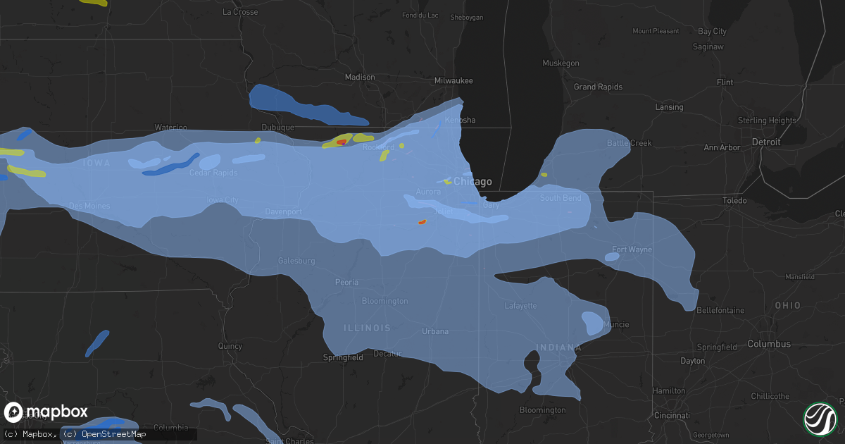
Hail Map on August 10, 2020
Get this storm
August 10 map
$229
one time, instant access
Download today. No call, no setup
Keep the $229
Bought the map and want the full workflow? Apply the entire $229 to a subscription within 7 days. None of it is wasted.
Every map, not just this one
This buys you this map. Subscription and you get every map we run, in the markets you choose from a few cities to whole states to nationwide. Plus real-time alerts the moment a storm fires.
Contact data
Name, contact info, occupancy, even credit band for addresses in the footprint. You go from where it hit to who to call.
Become the source they trust
Unlimited branding weather history reports on demand. You already have the documented answer ready for the property owner, and you are the one who showed up with it.
Property data and RoofTrace estimates
Pull up any address you have got, its value and the exact code rules for that jurisdiction, straight from One Click Code. Then RoofTrace estimates the squares, pitch, and roof value, priced the way you price.
States Impacted by Hail Map on August 10, 2020
Storm reports
Missouri
| Date | Description |
|---|---|
| 08/10/20206:58 PM CDT | Trees down. |
| 08/10/20206:57 PM CDT | Trees down in wheatland park. |
| 08/10/20206:40 PM CDT | Tennis ball size hail. Via social media. Delayed report. |
| 08/10/20206:28 PM CDT | Mesonet station wktm7 wah kon tah raws. |
| 08/10/20206:14 PM CDT | Tree down on route cc. |
| 08/10/20206:10 PM CDT | Delayed report: awning material removed from a structure on the property. Several trees down in the area southeast of the i-55/255 junction. |
| 08/10/20206:07 PM CDT | Sheriff reported ping pong sized hail along with a tree blown over. |
| 08/10/20206:05 PM CDT | Dispatch office reported hail the size of a half dollar. Time based on radar. |
| 08/10/20206:04 PM CDT | Strong winds were also reported... But no measurement or estimate was given. |
| 08/10/20206:04 PM CDT | 10 inch branch down at old hwy m and old lemay ferry road. |
| 08/10/20206:04 PM CDT | A large maple tree down on a house. The house suffered damage to the awning and gutters before rolling off the slanted roof. Power lines are also down in the area. Spot |
| 08/10/20206:00 PM CDT | Power pole down at the 3800 block of shaw blvd. |
| 08/10/20206:00 PM CDT | Delayed social media report of a tree limb down in a residential area. Limbs look to be about 6-8 inches in diameter. |
| 08/10/20206:00 PM CDT | 3-4 inch tree limbs down at gerald drive and tesson ferry road. |
| 08/10/20206:00 PM CDT | Power lines reported down near highlands plaza drive south of i-64/40. Power was out in the area. |
| 08/10/20206:00 PM CDT | Several 2 inch maple tree branches down near i-255 and telegraph raod. |
| 08/10/20205:55 PM CDT | Delayed report of a tree down on some power lines near rose acres and mckelvy. Time estimated by radar. |
| 08/10/20205:55 PM CDT | 1-2 inch tree limbs down... Power is out. |
| 08/10/20205:55 PM CDT | 5-6 inch tree limb down in tower grove south. |
| 08/10/20205:55 PM CDT | Delayed report of a large tree down on power lines near ameling road and bennington place. It was noted that several large trees were down in the area. Time estimated b |
| 08/10/20205:50 PM CDT | Power poles down along the service road. |
| 08/10/20205:46 PM CDT | Reported power line down causing power outages in neosho. Time based on radar. |
| 08/10/20205:45 PM CDT | Branches down at creve coeur park lake front. Portable traffic control sign blown over. |
| 08/10/20205:45 PM CDT | Large trees and power lines down. |
| 08/10/20205:45 PM CDT | Large tree limb down on creve coeur mill road at thomas patrick court. |
| 08/10/20205:41 PM CDT | Public reported a tree was down on a house off jungs station road in st. Peters. The fire dept was on the scene. |
| 08/10/20205:40 PM CDT | 6-8 inch tree limbs down... Short light pole down. |
| 08/10/20205:40 PM CDT | 8-12 inch tree limbs down on pralle lane. |
| 08/10/20205:38 PM CDT | Tree down over hwy dd near sommers road. |
| 08/10/20205:38 PM CDT | Via social media report of 2 inch size tree branches down. Time based on radar. |
| 08/10/20205:37 PM CDT | Gust observed by asos at spirit of st. Louis airport. |
| 08/10/20205:36 PM CDT | 1-2 inch softwood tree branches down at tom ginnever ave and st. Matthew ave. |
| 08/10/20205:35 PM CDT | 4-5 inch diameter limbs down... Pea to small marble sized hail. |
| 08/10/20205:35 PM CDT | 6 inch tree limbs down. |
| 08/10/20205:30 PM CDT | Via social media. Delayed report. Hail 2 to 2.5 inches. Time based on radar. |
| 08/10/20205:26 PM CDT | Tree down on hwy ww. |
| 08/10/20205:17 PM CDT | 12 inch diameter tree limb snapped and fell on garage. |
| 08/10/20205:12 PM CDT | Quarter size hail behind camp clark. Delayed report via social media. |
| 08/10/20205:12 PM CDT | Trees uprooted in very wet soil. |
| 08/10/20205:12 PM CDT | Two large highway signs blown down along hwy 61 near mile marker 47. |
| 08/10/20205:00 PM CDT | 6 inch tree limbs down... Wind blew into an open east-west facing gable barn and tore the tin roof halfway off. |
| 08/10/20204:40 PM CDT | Trees uprooted in very wet soil. |
| 08/10/20204:36 PM CDT | A local report indicates 60 MPH wind near 2 NE JEFFERSON CITY |
| 08/10/20204:33 PM CDT | A local report indicates 58 MPH wind near 2 N COLUMBIA |
| 08/10/20204:22 PM CDT | Two inch tree limbs down. |
| 08/10/20203:39 PM CDT | Maple tree downed in boonville. Numerous other trees damaged/ limbs blown down. |
| 08/10/20202:58 PM CDT | Home flagpole snapped and blown down. |
| 08/10/20202:45 PM CDT | Large tree blown down along highway 13 south of hale lake rd. Time estimated from radar. |
| 08/10/20202:45 PM CDT | Large tree limbs blown down on house. |
| 08/10/20202:40 PM CDT | A local report indicates 70 MPH wind near 4 ESE PITTSVILLE |
| 08/10/20202:24 PM CDT | Power lines down within the city of holden. |
| 08/10/20201:06 PM CDT | Several large limbs and power lines down on highway f near the intersection of highway u. |
| 08/10/20201:06 PM CDT | Power pole snapped at the intersection of highway 190 and highway p. |
| 08/10/20201:04 PM CDT | Several trees uprooted. Metal farm outbuildings heavily damaged. Aluminum grain trailer blown over. |
| 08/10/202012:49 PM CDT | Trained spotter reported trees down in memphis. This happened before any rain or storms arrived. |
| 08/10/202011:24 AM CDT | Report of an extended power outage between eagleville to blytheville due to an estimated 24 inch diameter healthy limb falling on and breaking power lines. |
| 08/10/202011:24 AM CDT | Emergency manager reported winds of around 60 mph moved through the eagleville to blythdale area. |
| 08/10/20207:58 AM CDT | At 1258 PM CDT, severe thunderstorms were located along a line extending from near Pattonsburg to 8 miles northeast of Gallatin to Jamesport to 11 miles south of Trenton to near Chillicothe, moving northeast at 25 mph. HAZARD...60 mph wind gusts and penny size hail. SOURCE...Emergency management. IMPACT...Expect damage to roofs, siding, and trees. Locations impacted include... Chillicothe, Trenton, Bethany, Princeton, Jamesport, Ridgeway, Gilman City, Pattonsburg, Eagleville, Cainsville, Linneus, Wheeling, Browning, Spickard, Galt, Chula, Laredo, Blythedale, Purdin and Coffey.This includes Interstate 35 in Missouri between mile markers 71 and109. |
| 08/10/20207:42 AM CDT | At 1242 PM CDT, severe thunderstorms were located along a line extending from near Lone Tree to near Lockridge, moving east at 65 mph. HAZARD...60 mph wind gusts. SOURCE...Trained weather spotters. IMPACT...Expect damage to roofs, siding, and trees. Locations impacted include... Rock Island, Burlington, Muscatine, Fort Madison, Mount Pleasant, Washington, Aledo, Wapello, Columbus Junction, Oquawka, Milan, Coal Valley, West Burlington, Burgess, New London, Mediapolis, Lone Tree, Andalusia, Winfield and Riverside. |
| 08/10/20207:05 AM CDT | At 1205 PM CDT, severe thunderstorms were located along a line extending from near Hedrick to near Lake Sundown, moving east at 45 mph. HAZARD...60 mph wind gusts. SOURCE...Radar indicated. IMPACT...Expect damage to roofs, siding, and trees. Locations impacted include... Fairfield, Keosauqua, Hedrick, Brighton, Richland, Batavia, Birmingham, Milton, Bonaparte, Libertyville, Stockport, Lockridge, Maharishi Vedic City, Cantril, Packwood, Martinsburg, Pleasant Plain, Abingdon, Douds and Bentonsport/Vernon. |
| 08/10/20206:58 AM CDT | At 1158 AM CDT, severe thunderstorms were located along a line extending from 7 miles southeast of Oskaloosa to 7 miles north of Unionville, moving east at 45 mph. These winds are from outflow from storms to the north and west. HAZARD...60 mph wind gusts. SOURCE...Trained weather spotters. IMPACT...Expect damage to roofs, siding, and trees. Locations impacted include... Ottumwa, Centerville, Bloomfield, Ottumwa Industrial Airport, Lake Sundown, Eldon, Fremont, Agency, Moulton, Cincinnati, Blakesburg, Pulaski, Drakesville, Kirkville, Exline, Floris, Unionville, Chillicothe, Udell and Sharon Bluffs State Park. |
| 08/10/20204:25 AM CDT | At 924 AM CDT, severe thunderstorms were located along a line extending from 5 miles north of Glenwood to 6 miles northwest of Bennet, moving southeast at 60 mph. HAZARD...60 mph wind gusts. SOURCE...Trained weather spotters. IMPACT...Expect damage to roofs, siding, and trees. Severe thunderstorms will be near... South Lincoln at 925 AM CDT. Glenwood around 930 AM CDT. Malvern around 935 AM CDT. Emerson, Unadilla and Douglas around 940 AM CDT. Syracuse around 945 AM CDT. Red Oak around 950 AM CDT. Essex, Stanton, Talmage and Lorton around 955 AM CDT.Other locations impacted by these severe thunderstorms includeThurman, Grant, Camp Catron, Manley, Hastings, Coburg, Burr,Waubonsie State Park, Silver City and Pierce Recreation Area.This includes Interstate 29 between mile markers 1 and 39. |
| 08/10/20202:36 AM CDT | At 735 PM CDT, severe thunderstorms were located along a line extending from 8 miles west of Mcleansboro to near Murphysboro, moving east at 65 mph. HAZARD...60 mph wind gusts. SOURCE...Radar indicated. IMPACT...Expect damage to roofs, siding, and trees. Locations impacted include... Carbondale, Marion, Herrin, West Frankfort, Murphysboro, Carterville, Johnston City, Christopher, Zeigler, De Soto, Crainville, Cambria, Royalton, Energy, Elkville, Hurst, Ava, Grand Tower, Pittsburg and Creal Springs.This includes the following highways... Interstate 24 in Illinois between Mile Markers 1 and 2. Interstate 57 in Illinois between Mile Markers 43 and 69. |
| 08/10/20201:54 AM CDT | At 654 PM CDT, severe thunderstorms were located along a line extending from near Hermitage to near Urbana to 10 miles north of Bolivar to near Humansville, moving east at 35 mph. HAZARD...60 mph wind gusts and nickel size hail. SOURCE...Radar indicated. IMPACT...Expect damage to roofs, siding, and trees. Locations impacted include... Pomme de Terre Lake... Pomme De Terre State Park... Bennett Spring State Park... Buffalo... Pittsburg... Polk... Hermitage... Urbana... Wheatland... Macks Creek... Preston... Halfway... Flemington... Louisburg... Windyville... Quincy... Tunas... Pumpkin Center... Branch... Plad... |
| 08/10/20201:00 AM CDT | At 559 PM CDT, a severe thunderstorm was located 1 mile east of Rolla, moving east at 25 mph. HAZARD...60 mph wind gusts and quarter size hail. SOURCE...Radar indicated. IMPACT...Hail damage to vehicles is expected. Expect wind damage to roofs, siding, and trees. Locations impacted include... East Rolla... St. James... Rosati... This includes Interstate 44 between mile markers 189 and 200. |
| 08/10/202012:59 AM CDT | At 559 PM CDT, severe thunderstorms were located along a line extending from Black Jack to near Antonia to near De Soto, moving east at 40 mph. HAZARD...60 mph wind gusts. SOURCE...Trained weather spotters. IMPACT...Expect damage to roofs, siding, and trees. Locations impacted include... St. Louis, Belleville, University City, Granite City, O'Fallon, East St. Louis, Collinsville, Edwardsville, Webster Groves, Ferguson, Arnold, Fairview Heights, Clayton, Cahokia, Jennings, Swansea, Glen Carbon, Shiloh, Crestwood and Festus.This includes the following highways... Interstate 70 in Illinois between exits 21 and 30. Interstate 55 in Illinois near exit 23. Interstate 64 in Illinois between exits 9 and 61. Interstate 55 in Missouri between exits 170 and 191.This also includes Scott Joplin Historic Site, Mastodon HistoricSite, Gov. Dunklin's Grave Historic Site, Carlyle Lake RecreationalArea, and Horseshoe Lake State Park. |
| 08/10/202012:47 AM CDT | At 547 PM CDT, a severe thunderstorm was located over Salem, moving east at 10 mph. HAZARD...60 mph wind gusts and nickel size hail. SOURCE...Radar indicated. IMPACT...Expect damage to roofs, siding, and trees. Locations impacted include... Salem... Boss... Howes... Stone Hill... Howes Mill... |
| 08/10/202012:26 AM CDT | At 525 PM CDT, a severe thunderstorm was located near Walker, or 8 miles east of Nevada, moving east at 20 mph. HAZARD...60 mph wind gusts and half dollar size hail. SOURCE...Radar indicated. IMPACT...Hail damage to vehicles is expected. Expect wind damage to roofs, siding, and trees. Locations impacted include... El Dorado Springs... Walker... Taberville... Caplinger Mills... Cedar Springs... Tiffin... |
| 08/10/202012:16 AM CDT | At 514 PM CDT, severe thunderstorms were located along a line extending from near Bunker Hill to near St. Paul to Beaufort, moving southeast at 45 mph. HAZARD...60 mph wind gusts. SOURCE...Law enforcement. IMPACT...Expect damage to roofs, siding, and trees. Locations impacted include... St. Louis, St. Charles, St. Peters, Florissant, Chesterfield, Belleville, Wildwood, University City, Ballwin, Granite City, Wentzville, O'Fallon, Alton, Kirkwood, Maryland Heights, East St. Louis, Hazelwood, Collinsville, Edwardsville and Webster Groves.This includes the following highways... Interstate 70 in Illinois between exits 21 and 30. Interstate 55 in Illinois between exits 23 and 44. Interstate 64 in Illinois between exits 9 and 27. Interstate 44 in Missouri between exits 230 and 277. Interstate 55 in Missouri between exits 175 and 191. Interstate 70 in Missouri between exits 212 and 231.This also includes Babler Memorial State Park, Scott Joplin HistoricSite, Route 66 State Park, Castlewood State Park, Confluence StatePark, Mastodon Historic Site, Sandy Creek Covered Bridge HistoricSite, Gov. Dunklin's Grave Historic Site, First Missouri StateCapitol Historic Site, Robertsville State Park, and Horseshoe LakeState Park. |
| 08/09/202011:39 PM CDT | At 438 PM CDT, severe thunderstorms were located along a line extending from Montgomery City to near Chamois to near Taos, moving east at 45 mph. HAZARD...60 mph wind gusts and penny size hail. SOURCE...Automated weather station in Jefferson City reported a wind gust of 60 miles per hour. IMPACT...Expect damage to roofs, siding, and trees. Locations impacted include... O'Fallon, St. Peters, Jefferson City, Wentzville, Lake St. Louis, Washington, Dardenne Prairie, Union, Warrenton, Weldon Spring, Wright City, Cottleville, Owensville, Hermann, New Haven, St. Paul, Linn, Villa Ridge, Gerald and Marthasville.This includes Interstate 70 in Missouri between exits 170 and 220. This also includes Deutschheim Historic Site, Clarks Hill/NortonHistoric Site, and Graham Cave State Park. |
| 08/09/202010:26 PM CDT | At 326 PM CDT, severe thunderstorms were located along a line extending from Sedalia to 7 miles north of Cole Camp to near Lincoln, moving east at 45 mph. HAZARD...60 mph wind gusts and quarter size hail. SOURCE...Radar indicated. IMPACT...Hail damage to vehicles is expected. Expect wind damage to roofs, siding, and trees. Locations impacted include... Versailles... Cole Camp... Stover... Syracuse... Ionia... Mora... Florence... Brandon... Crockerville... |
| 08/09/202010:20 PM CDT | At 319 PM CDT, severe thunderstorms were located along a line extending from near Blackburn to 8 miles east of Sweet Springs to 9 miles east of Houstonia to 6 miles north of Sedalia to 7 miles east of Green Ridge, moving east at 60 mph. HAZARD...70 mph wind gusts and nickel size hail. SOURCE...Trained weather spotters. IMPACT...Expect considerable tree damage. Damage is likely to mobile homes, roofs, and outbuildings. Locations impacted include... Sedalia, Moberly, Marshall, Boonville, Fayette, Slater, Sweet Springs, Glasgow, New Franklin, Pilot Grove, Smithton, Higbee, Green Ridge, Otterville, Alma, Bunceton, Clark, Armstrong, Malta Bend and Blackburn.This includes Interstate 70 in Missouri between mile markers 64 and114. |
| 08/09/20209:39 PM CDT | At 239 PM CDT, severe thunderstorms were located along a line extending from near Odessa to 11 miles southwest of Mayview to 9 miles northeast of Holden to 6 miles west of Warrensburg to 7 miles north of Chilhowee, moving northeast at 50 mph. HAZARD...70 mph wind gusts and penny size hail. SOURCE...Radar indicated. IMPACT...Expect considerable tree damage. Damage is likely to mobile homes, roofs, and outbuildings. Locations impacted include... Sedalia, Warrensburg, Marshall, Odessa, Higginsville, Carrollton, Knob Noster, Concordia, Sweet Springs, Whiteman Air Force Base, La Monte, Waverly, Corder, Alma, Chilhowee, Malta Bend, Blackburn, Houstonia, Mayview and Whiteman Afb.This includes Interstate 70 in Missouri between mile markers 33 and83. |
| 08/09/20209:24 PM CDT | At 223 PM CDT, severe thunderstorms were located along a line extending from near Kirksville to 7 miles southeast of Atlanta, moving northeast at 30 mph. HAZARD...60 mph wind gusts and quarter size hail. SOURCE...Radar indicated. IMPACT...Hail damage to vehicles is expected. Expect wind damage to roofs, siding, and trees. Locations impacted include... Edina, La Belle, Shelbyville, Knox City, Greensburg, Plevna, Steffenville, Colony, Hurdland, Novelty, Baring, Bethel, Newark and Leonard. |
| 08/09/20209:10 PM CDT | At 210 PM CDT, severe thunderstorms were located along a line extending from near Harrisonville to East Lynne to near Garden City, moving northeast at 35 mph. HAZARD...60 mph wind gusts and quarter size hail. SOURCE...Radar indicated. IMPACT...Hail damage to vehicles is expected. Expect wind damage to roofs, siding, and trees. Locations impacted include... Raymore, Warrensburg, Harrisonville, Pleasant Hill, Oak Grove, Greenwood, Peculiar, Knob Noster, Holden, Lake Lotawana, Garden City, Whiteman Air Force Base, Lake Winnebago, Lone Jack, Cleveland, Freeman, Creighton, Chilhowee, East Lynne and Kingsville. |
| 08/09/20207:30 PM CDT | Several trees snapped in yard and along roadway. Via social media. |
| 08/09/20207:11 PM CDT | Delayed report of several downed trees and a flagpole snapped in a yard. Time estimated from radar. |
| 08/09/20207:06 PM CDT | Power poles snapped near base at tesson ferry rd. And griffin rd. |
| 08/09/20207:00 PM CDT | Winds 55 mph... Gusting to 65 mph. |
Kentucky
| Date | Description |
|---|---|
| 08/10/20204:20 PM CDT | Several trees and large branches down along mccoy-witty road. Public report relayed by broadcast media. |
| 08/10/20205:53 AM CDT | At 1052 PM EDT, a severe thunderstorm was located near Williamsburg, moving southeast at 30 mph. HAZARD...60 mph wind gusts. SOURCE...Radar indicated. IMPACT...Expect damage to trees and power lines. Locations impacted include... Georgetown, Blanchester, Forestville, Amelia, Mount Orab, Bethel, Williamsburg, Batavia, Lynchburg, Winchester, Sardinia, Belfast, Withamsville, Coldstream, Woodville, New Market, Sherwood, Owensville, Emerald and Russellville. |
Idaho
| Date | Description |
|---|---|
| 08/10/20202:36 AM CDT | At 735 PM MDT, a severe thunderstorm was located 13 miles north of Juniper, or 20 miles northwest of Snowville, moving northeast at 30 mph. HAZARD...60 mph wind gusts and quarter size hail. SOURCE...Radar indicated. IMPACT...Hail damage to vehicles is expected. Expect wind damage to roofs, siding, and trees. Locations impacted include... Juniper, Roy and Sweetzer Summit. |
Ohio
| Date | Description |
|---|---|
| 08/10/20205:26 PM CDT | Numerous large tree limbs broke off. One branch went through a car windshield and a second branch fell onto a garage roof causing minor structural damage. |
| 08/10/20203:41 AM CDT | At 840 PM EDT, a severe thunderstorm was located near St. Marys, moving east at 35 mph. HAZARD...60 mph wind gusts. SOURCE...Radar indicated. IMPACT...Expect damage to trees and power lines. Locations impacted include... Celina, Wapakoneta, St. Marys, New Bremen, Minster, St. Henry, Cridersville, Fort Loramie, New Knoxville, Moulton, Chickasaw, Burkettsville, Buckland, Kettlersville, Montezuma, Kossuth, Egypt, Lake Loramie State Park, Maria Stein and Neptune. |
| 08/10/20203:27 AM CDT | At 826 PM EDT, severe thunderstorms were located along a line extending from near Celina to near Fort Recovery, moving east at 65 mph. HAZARD...60 mph wind gusts. SOURCE...Radar indicated. IMPACT...Expect damage to trees and power lines. Locations impacted include... Celina, Coldwater, St. Henry, Fort Recovery, Chickasaw, Burkettsville, Montezuma, Neptune, Carthagena and Maria Stein. |
| 08/10/20203:03 AM CDT | At 803 PM EDT, severe thunderstorms were located along a line extending from near Monroe to near Pennville, moving east at 35 mph. HAZARD...60 mph wind gusts. SOURCE...Radar indicated. IMPACT...Expect damage to trees and power lines. Locations impacted include... Celina, Coldwater, Rockford, Wabash, Mendon, Chattanooga and Tama. |
| 08/10/20202:51 AM CDT | At 751 PM EDT, severe thunderstorms were located along a line extending from near Butler to near Woodburn to near Decatur, moving east at 45 mph. HAZARD...70 mph wind gusts. SOURCE...Radar indicated. IMPACT...Expect considerable tree damage. Damage is likely to mobile homes, roofs, and outbuildings. Severe thunderstorms will be near... Edgerton In Williams County around 800 PM EDT. Antwerp and Payne around 805 PM EDT. Convoy around 810 PM EDT. Bryan, Paulding and Ohio City around 815 PM EDT. Van Wert around 820 PM EDT. Ottoville around 835 PM EDT. |
| 08/10/20202:18 AM CDT | At 717 PM EDT, severe thunderstorms were located along a line extending from near Albion to 9 miles northeast of Huntington, moving east at 35 mph. HAZARD...70 mph wind gusts. SOURCE...Radar indicated. IMPACT...Expect considerable tree damage. Damage is likely to mobile homes, roofs, and outbuildings. Severe thunderstorms will be near... Churubusco around 720 PM EDT. Kendallville around 725 PM EDT. Avilla around 730 PM EDT. Ossian around 735 PM EDT. Garrett around 740 PM EDT. Auburn and Waterloo around 745 PM EDT. New Haven around 750 PM EDT. Butler and St. Joe around 755 PM EDT.This includes the following highways... Interstate 469 between mile markers 0 and 30. Interstate 69 in Indiana between mile markers 286 and 340. |
| 08/09/20209:44 PM CDT | Trees down |
| 08/09/20209:02 PM CDT | Tree downed... About 8 inches in diameter... Near intersection of hastings drive and ridgebury drive. Time estimated by radar. |
| 08/09/20208:49 PM CDT | Multiple trees downed along vance road. Time estimated by radar. |
| 08/09/20208:07 PM CDT | Large tree down on state road 109. Time estimated from radar. |
| 08/09/20208:05 PM CDT | Downed tree on county road 10 between county roads s and t. Time estimated from radar. |
| 08/09/20208:00 PM CDT | Tree down in the area. Time is estimated. |
| 08/09/20207:50 PM CDT | Tree down near 112 st. State route 119. |
| 08/09/20207:39 PM CDT | Tree down on road... Suv struck the tree that was down. No reported injuries. |
| 08/09/20207:38 PM CDT | Trees down across road. |
| 08/09/20207:30 PM CDT | Trees and power lines down in the area. Time estimated. |
| 08/09/20207:26 PM CDT | Large tree down in ohio city. Time estimated from radar. |
| 08/09/20207:26 PM CDT | Corrects previous tstm wnd dmg report from 1 ne glenmore. Numerous large tree limbs broke off. One branch went through a car windshield and a second branch fell onto a |
| 08/09/20207:13 PM CDT | Large tree down in convoy. Time estimated from radar. |
| 08/09/20207:13 PM CDT | Trees and power lines down across the town of hicksville. |
Florida
| Date | Description |
|---|---|
| 08/10/20202:52 AM CDT | At 752 PM EDT, a severe thunderstorm was located near Lake Louisa, or 11 miles west of Bay Lake, moving southwest at 15 mph. HAZARD...60 mph wind gusts and quarter size hail. SOURCE...Radar indicated. IMPACT...Hail damage to vehicles is expected. Expect wind damage to roofs, siding, and trees. Locations impacted include... Lake Louisa. |
Wisconsin
| Date | Description |
|---|---|
| 08/10/20205:00 PM CDT | Tree reported down at location. |
| 08/10/20204:55 PM CDT | Large tree limbs down at location. |
| 08/10/20204:21 PM CDT | Large branches down. Report relayed via social media. Time estimated from radar. |
| 08/10/20204:15 PM CDT | Large tree limbs down at location. |
| 08/10/20204:13 PM CDT | Two mature pine trees down around lathrop ave and foxwood rd in mt. Pleasant. Time estimated by radar. |
| 08/10/20204:13 PM CDT | Large limbs down and damage to siding. Report relayed via social media. Time estimated from radar. |
| 08/10/20204:10 PM CDT | Several reports of tree down in union grove. Time estimated by radar. |
| 08/10/20204:09 PM CDT | A local report indicates 60 MPH wind near POWERS LAKE |
| 08/10/20204:07 PM CDT | Large tree branches down in the city of kenosha. Report relayed via social media. |
| 08/10/20204:00 PM CDT | Numerous reports of trees... Tree limbs... And powerlines down across walworth county. |
| 08/10/20203:55 PM CDT | Reports relayed via social media of powerlines and large tree branches down with estimated 70 mph winds. Time estimated based on radar. |
| 08/10/20203:55 PM CDT | A local report indicates 70 MPH wind near PADDOCK LAKE |
| 08/10/20203:52 PM CDT | Trees down around the intersection of hwy z and hwy p in powers lake. |
| 08/10/20203:47 PM CDT | Tree snapped at location. Report relayed via social media. Time estimated from radar. |
| 08/10/20203:47 PM CDT | Multiple reports of trees and wires down around the camp lake area. |
| 08/10/20203:45 PM CDT | Damage to buildings and trees consistent with a low end ef-1 tornado occurred in northern illinois just south of the wisconsin state line. This tornado proceeded ne int |
| 08/10/20203:45 PM CDT | Corrects previous flood report from 2 ssw camp lake. Numerous trees down and snapped at wilmot and 286th. Report relayed via social media. Time estimated from radar. |
| 08/10/20203:38 PM CDT | Multiple trees down on lake geneva blvd and west south street. Report passed along by broadcast media. Time estimated from radar. |
| 08/10/20203:38 PM CDT | Storm survey crew found damage consistent with a high end ef-0 in lake geneva. Winds upwards of 80 mph occurred and much of the damage was to trees. Large limbs and tre |
| 08/10/20203:38 PM CDT | Multiple reports of trees and tree limbs down in the city of lake geneva. Time estimated based on radar. |
| 08/10/20202:30 PM CDT | Tree down across road at location. Report relayed via picture on social media. Time estimated from radar. |
| 08/10/20202:25 PM CDT | A local report indicates 62 MPH wind near 3 ENE MONROE |
| 08/10/20202:20 PM CDT | Social media report of a downed tree in monroe... Wi. Time estimated based on radar. |
| 08/10/20202:05 PM CDT | Many large tree limbs down in yard... Some on the house. 3 trees down on a nearby road. |
| 08/10/20201:29 PM CDT | Multiple reports of downed powerlines... Tree branches... And a blown transformer around alice st. And galena st. On the south side of darlington. Time estimated based |
| 08/10/20201:20 PM CDT | Tree damage and power outages. |
| 08/10/20201:15 PM CDT | 4 roads blocked off in the town and 8-10 inch trees and tree limbs down. |
| 08/10/20201:14 PM CDT | Tree fell on house. |
| 08/10/20201:14 PM CDT | Tall tree snapped at the top. Time estimated from radar. |
| 08/10/20201:13 PM CDT | Power lines and trees down. |
| 08/10/20201:11 PM CDT | Power outages in lancaster/fennimore areas. |
| 08/10/20201:10 PM CDT | Trees down. Reported via social media. Time estimated. |
| 08/10/20201:10 PM CDT | Tree damage and wind gusts of 62 mph. |
| 08/10/20201:09 PM CDT | Multiple reports of a semi truck tipped over on hwy 151 between belmont and platteville. Time estimated based on radar. |
| 08/10/20201:05 PM CDT | Storm spotter reported a funnel with corn leaves/stocks and steel siding debris. |
| 08/10/202012:50 PM CDT | . |
| 08/10/202012:49 PM CDT | . |
| 08/10/202012:32 PM CDT | A brief tornado touched down damaging hardwood trees... Two outbuildings... And downing power lines. Observer of tornado saw corn stalks and metal material from the out |
| 08/10/202012:30 PM CDT | Possible tornado damage. Relayed via emergency management. |
| 08/10/202012:30 PM CDT | . |
| 08/10/20208:55 AM CDT | Tree down. Delayed report from social media. Time estimated by radar. |
| 08/10/20208:28 AM CDT | Trees down along county highway a. Delayed report. Time estimated by radar. |
| 08/10/20208:20 AM CDT | Trees down. Delayed report. Time estimated by radar. |
| 08/10/20208:03 AM CDT | Law enforcement reported a tree down near 13th drive and cypress drive. |
| 08/10/20207:48 AM CDT | Law enforcement reported a tree down in armenia township. |
| 08/10/20207:35 AM CDT | Large tree down at the intersection of highway 80 and 54. Delayed report from social media. Time estimated by radar. |
| 08/10/20207:34 AM CDT | At 1233 PM CDT, severe thunderstorms were located along a line extending from near Boscobel to Balltown, moving east at 45 mph. HAZARD...60 mph wind gusts and penny size hail. SOURCE...Trained weather spotters. A 63 MPH wind gust was measured in Patch Grove in Grant County. IMPACT...Expect damage to roofs, siding, and trees. Locations impacted include... Dodgeville, Mineral Point, Darlington, Shullsburg, Belmont, Benton, Argyle, Blanchardville, Barneveld, Wiota, Highland, Arena, Ridgeway, Avoca, Linden, New Diggings, South Wayne, Waldwick, Elk Grove and Cobb.This includes the following Locations Hyde's Mill, The House on theRock, and Iowa-Grant School. |
| 08/10/20207:04 AM CDT | At 1204 PM CDT, severe thunderstorms were located along a line extending from near Harpers Ferry to near McGregor to near Garnavillo, moving east at 35 mph. HAZARD...60 mph wind gusts and quarter size hail. SOURCE...Radar indicated. IMPACT...Hail damage to vehicles is expected. Expect wind damage to roofs, siding, and trees. Severe thunderstorms will be near... Bloomington around 1220 PM CDT. Cassville around 1225 PM CDT. Boscobel around 1235 PM CDT. Lancaster around 1240 PM CDT. Fennimore around 1245 PM CDT.Other locations impacted by these severe thunderstorms includeEastman, Highway 61 And County T, Giard, Turkey River, Beetown,County Roads K And T and Bridgeport. |
| 08/10/20207:00 AM CDT | A local report indicates 58 MPH wind near BLACK RIVER FALLS |
| 08/10/20203:38 AM CDT | At 838 AM CDT, severe thunderstorms were located along a line extending from near Amherst to 7 miles southwest of Hartman Creek State Park to 6 miles southwest of Wautoma, moving east at 45 mph. HAZARD...60 mph wind gusts and penny size hail. SOURCE...Radar indicated. IMPACT...Expect damage to roofs, siding, and trees. Severe thunderstorms will be near... Napowan Scout Camp around 845 AM CDT. Hartman Creek State Park around 850 AM CDT. Waupaca, Redgranite and Chain O' Lakes-King around 855 AM CDT.Other locations impacted by these severe thunderstorms include Rural,Saxeville, Lind Center, Mount Morris, Auroraville, Wild Rose, EmmonsCreek Barrens, Borth, Sheridan and Silver Lake. |
| 08/10/20203:02 AM CDT | At 801 AM CDT, a severe thunderstorm was located over Friendship, moving east at 50 mph. HAZARD...60 mph wind gusts and nickel size hail. SOURCE...Radar indicated. IMPACT...Expect damage to roofs, siding, and trees. Locations impacted include... Berlin, Westfield, Lawrence, Neshkoro, Springfield Corners and Harrisville. |
| 08/10/20202:57 AM CDT | At 757 AM CDT, severe thunderstorms were located along a line extending from near New Rome to 12 miles north of Friendship to near Adams, moving east at 45 mph. HAZARD...60 mph wind gusts. SOURCE...Radar indicated. IMPACT...Expect damage to roofs, siding, and trees. Severe thunderstorms will be near... Lake Wazeecha around 800 AM CDT. Plainfield around 820 AM CDT. Wautoma around 835 AM CDT.Other locations impacted by these severe thunderstorms includeColoma, Wild Rose, Hancock, Port Edwards, Kellner, Silver Lake,Keene, Heffron, Almond and Blaine. |
| 08/10/20202:20 AM CDT | At 720 AM CDT, severe thunderstorms were located along a line extending from 11 miles south of Shortville to 15 miles northwest of Necedah to 6 miles southeast of Tomah, moving east at 50 mph. HAZARD...60 mph wind gusts and quarter size hail. SOURCE...Radar indicated. IMPACT...Hail damage to vehicles is expected. Expect wind damage to roofs, siding, and trees. Severe thunderstorms will be near... New Lisbon around 735 AM CDT. Necedah around 740 AM CDT. Dellwood around 745 AM CDT. Friendship, Adams and New Rome around 755 AM CDT.Other locations impacted by these severe thunderstorms include NewMiner, Highways 13 And 21, County Roads G And O, County Roads G AndM, Highway 13 And County E, County Roads C And G and Buckhorn StatePark. |
| 08/10/20202:09 AM CDT | At 708 AM CDT, a severe thunderstorm was located 9 miles northeast of Millston, or 16 miles east of Black River Falls, moving east at 50 mph. HAZARD...60 mph wind gusts. SOURCE...Radar indicated. IMPACT...Expect damage to roofs, siding, and trees. This severe thunderstorm will be near... Babcock around 730 AM CDT. Wisconsin Rapids around 750 AM CDT.Other locations impacted by this severe thunderstorm include SandhillWildlife Area, Nekoosa, Walker, Veedum, Scranton, Dexterville,Cranmoor, Port Edwards and Biron. |
| 08/10/20201:51 AM CDT | At 651 AM CDT, severe thunderstorms were located along a line extending from 6 miles northwest of Black River Falls to 6 miles north of Cataract to 6 miles northwest of Sparta, moving east at 40 mph. HAZARD...60 mph wind gusts and quarter size hail. SOURCE...Radar indicated. IMPACT...Hail damage to vehicles is expected. Expect wind damage to roofs, siding, and trees. Severe thunderstorms will be near... Cataract around 655 AM CDT. Sparta around 700 AM CDT. Black River Falls around 705 AM CDT. Millston, Fort Mc Coy and Hatfield around 710 AM CDT. Tomah around 725 AM CDT.Other locations impacted by these severe thunderstorms includeWarrens, City Point, Shamrock, The Black River Correctional Center,Pigeon Creek Campground, Potters Flowage and The North Flowage. |
| 08/09/202011:21 PM CDT | At 421 PM CDT, a severe thunderstorm was located near Camp Rokilio Scout Camp, or near Howards Grove, moving east at 25 mph. HAZARD...60 mph wind gusts and quarter size hail. SOURCE...Radar indicated. IMPACT...Hail damage to vehicles is expected. Expect wind damage to roofs, siding, and trees. Locations impacted include... Plymouth, Howards Grove, Elkhart Lake, Greenbush, Glenbeulah, Haven and Johnsonville. |
| 08/09/202011:20 PM CDT | At 419 AM CDT, severe thunderstorms were located along a line extending from near Red Wing to Wanamingo to near Waseca, moving east at 35 mph. HAZARD...60 mph wind gusts and quarter size hail. SOURCE...Radar indicated. IMPACT...Hail damage to vehicles is expected. Expect wind damage to roofs, siding, and trees. Severe thunderstorms will be near... Mazeppa around 440 AM CDT. Oronoco around 445 AM CDT. Claremont around 500 AM CDT. Wabasha and Elgin around 505 AM CDT. Dodge Center around 510 AM CDT. Plainview and Hayfield around 515 AM CDT. Kasson around 520 AM CDT. Kellogg around 525 AM CDT.Other locations impacted by these severe thunderstorms include SouthTroy, Potsdam, Eden, Highway 57 And 570th Street, County Roads 6 And15, Hidden Meadows R V Park and Rock Dell. |
| 08/09/202011:14 PM CDT | At 414 PM CDT, severe thunderstorms were located along a line extending from near Ephraim to 8 miles west of Sturgeon Bay, moving east at 20 mph. HAZARD...60 mph wind gusts and quarter size hail. SOURCE...Radar indicated. IMPACT...Hail damage to vehicles is expected. Expect wind damage to roofs, siding, and trees. Locations impacted include... Jacksonport, Ephraim, Egg Harbor, Newport State Park, Whitefish Bay, Baileys Harbor, Sister Bay, Peninsula Center, Fish Creek and Peninsula State Park. |
| 08/09/202011:10 PM CDT | At 410 AM CDT, severe thunderstorms were located along a line extending from 6 miles south of Welch to near Kenyon to 6 miles northeast of Medford, moving east at 30 mph. HAZARD...60 mph wind gusts and quarter size hail. SOURCE...Radar indicated. IMPACT...Hail damage to vehicles is expected. Expect wind damage to roofs, siding, and trees. Locations impacted include... Pine Island, Zumbrota, Kenyon, Goodhue, Wanamingo, Nerstrand, Vasa, Bellechester, Wastedo, Central Point, Ruskin and Bombay. |
| 08/09/202010:35 PM CDT | At 335 PM CDT, a severe thunderstorm was located 8 miles northwest of Newport State Park, or 28 miles northeast of Menominee, moving east at 30 mph. HAZARD...60 mph wind gusts and quarter size hail. SOURCE...Radar indicated. IMPACT...Hail damage to vehicles is expected. Expect wind damage to roofs, siding, and trees. Locations impacted include... Ephraim, Newport State Park, Sister Bay, Washington Island, Peninsula State Park, Ellison Bay, Rock Island State Park, Rowleys Bay and Fish Creek. |
| 08/09/202010:10 PM CDT | At 309 PM CDT, a severe thunderstorm was located 7 miles north of Menominee, moving east at 20 mph. HAZARD...60 mph wind gusts and quarter size hail. SOURCE...Radar indicated. IMPACT...Hail damage to vehicles is expected. Expect wind damage to roofs, siding, and trees. Locations impacted include... Birch Creek. |
| 08/09/20209:52 PM CDT | At 252 PM EDT/152 PM CDT/, severe thunderstorms were located along a line extending from 8 miles northeast of Powers to 10 miles southeast of Pembine, moving east at 20 mph. HAZARD...60 mph wind gusts and quarter size hail. SOURCE...Radar indicated. IMPACT...Hail damage to vehicles is expected. Expect wind damage to roofs, siding, and trees. Locations impacted include... Escanaba, Stephenson, Powers, Bagley, Ford River, Wilson, Spalding, Bark River, Nadeau, Gourley, Daggett and Carney. |
| 08/09/20209:43 PM CDT | At 242 PM CDT, severe thunderstorms were located along a line extending from 8 miles north of Cedar River to 6 miles southwest of Stephenson, moving east at 25 mph. HAZARD...60 mph wind gusts and quarter size hail. SOURCE...Radar indicated. IMPACT...Hail damage to vehicles is expected. Expect wind damage to roofs, siding, and trees. Locations impacted include... Stephenson, Cedar River, Wallace, Ingalls, Carbondale and Wells State Park. |
| 08/09/20209:24 PM CDT | At 224 PM CDT, severe thunderstorms were located along a line extending from Warren to near German Valley to near Princeton to near Williamsfield, moving east at 65 mph. These are very dangerous storms. HAZARD...80 mph wind gusts and quarter size hail. SOURCE...Automated wind measurements. This storm has a history of producing measured wind gusts in excess of 80 mph! IMPACT...Flying debris will be dangerous to those caught without shelter. Mobile homes will be heavily damaged. Expect considerable damage to roofs, windows, and vehicles. Extensive tree damage and power outages are likely. Locations impacted include... Aurora, Joliet, Elgin, Bartlett, Crystal Lake, Plainfield, Carpentersville, St. Charles, Oswego, Algonquin, Lake in the Hills, West Chicago, McHenry, Batavia, Woodstock, Huntley, Geneva, Yorkville, Morris and Channahon.Including the following interstates... I-55 between mile markers 219 and 234. I-80 between mile markers 104 and 123. I-88 between mile markers 102 and 120. I-90 between mile markers 32 and 56.This includes... Aurora University, Elgin Community College,Fermilab, Gebhard Woods State Park, Grundy County Speedway andFairgrounds, IL Math and Science Academy, Kane County CougarsBallpark, Mchenry County College, Mchenry County Fairgrounds, MoraineHills State Park, Waubonsee Community College, and William G StrattonState Park. |
| 08/09/20208:41 PM CDT | At 141 PM CDT, severe thunderstorms were located along a line extending from Centralia to near Springbrook to near Princeton to near Little York, moving east at 70 mph. These storms are producing widespread wind damage! HAZARD...70 mph wind gusts and quarter size hail. SOURCE...Radar indicated. IMPACT...Hail damage to vehicles is expected. Expect considerable tree damage. Wind damage is also likely to mobile homes, roofs, and outbuildings. Locations impacted include... Rockford, Beloit, Loves Park, Machesney Park, Dixon, Roscoe, Rochelle, South Beloit, Rockton, Byron, Oregon, Mount Morris, Amboy, Polo, Rockford Airport, Cherry Valley, Winnebago, Davis Junction, Pecatonica and Forreston.Including the following interstates... I-39 between mile markers 78 and 123. I-88 between mile markers 45 and 82. I-90 between mile markers 0 and 18.This includes... Castle Rock State Park, Lee County Fairgrounds,Lowden State Park, Ogle County Fairgrounds, Rock Cut State Park, RockValley College, Rockford Rivets Baseball, Rockford Speedway, SaukValley College, White Pines State Park, and Winnebago CountyFairgrounds. |
| 08/09/20208:26 PM CDT | At 125 PM CDT, severe thunderstorms were located along a line extending from near Dodgeville to near Woodbine, moving northeast at 40 mph. HAZARD...70 mph wind gusts and quarter size hail. SOURCE...Trained weather spotters. These storms have a history of producing wind damage and power outages. IMPACT...Hail damage to vehicles is expected. Expect considerable tree damage. Wind damage is also likely to mobile homes, roofs, and outbuildings. Locations impacted include... Madison, Fitchburg, Middleton, Waunakee, Monroe, Verona, Oregon, Mount Horeb, Dodgeville, Brodhead, Mineral Point, Darlington, Cross Plains, Belleville, New Glarus, Shorewood Hills, Brooklyn, Black Earth, Maple Bluff and Monticello.This includes the following Locations York Memorial Church, WisconsinState Capitol, and Hyde's Mill. |
| 08/09/20208:09 PM CDT | At 109 PM CDT, a severe thunderstorm was located 8 miles southeast of Norway, or 16 miles southeast of Iron Mountain, moving east at 15 mph. HAZARD...60 mph wind gusts and quarter size hail. SOURCE...Radar indicated. IMPACT...Hail damage to vehicles is expected. Expect wind damage to roofs, siding, and trees. Locations impacted include... Powers, Hermansville, Bagley, Wilson, Spalding, Nadeau, Waucedah, Gourley, Faithorn, Carney, Loretto and Cunard. |
Illinois
| Date | Description |
|---|---|
| 08/10/20206:41 PM CDT | Roof damage to supermarket. |
| 08/10/20206:37 PM CDT | Strong winds out ahead of a thunderstorm as a gust front. Small and medium size tree branches down. Winds estimated to be about 50-55 mpr. |
| 08/10/20206:37 PM CDT | 4 to 5 inch tree limbs down... Power lines down. Wind gusts estimated at 50 mph. |
| 08/10/20206:20 PM CDT | Powerlines down. |
| 08/10/20206:19 PM CDT | 12-14 inch tree limb over paula drive. |
| 08/10/20206:13 PM CDT | A local report indicates 60 MPH wind near 1 ENE CAHOKIA |
| 08/10/20206:00 PM CDT | Large tree down blocking the roadway near intersection of spring st and lebanon road. |
| 08/10/20205:49 PM CDT | Powerline down. |
| 08/10/20205:42 PM CDT | Tree down. |
| 08/10/20205:37 PM CDT | 4 inch diameter tree limb down with the gust front. |
| 08/10/20205:36 PM CDT | 2 inch tree limb blown down. |
| 08/10/20205:27 PM CDT | Large tree limbs snapped |
| 08/10/20205:14 PM CDT | A local report indicates 60 MPH wind near COLES COUNTY AIRPORT |
| 08/10/20205:09 PM CDT | Corrected time |
| 08/10/20205:05 PM CDT | Tree limb down. |
| 08/10/20204:50 PM CDT | Numerous trees and power lines down throughout danville. Several streets blocked. |
| 08/10/20204:43 PM CDT | A local report indicates 75 MPH wind near 2 NNW DANVILLE |
| 08/10/20204:40 PM CDT | Two large trees down blocking us 150. |
| 08/10/20204:30 PM CDT | Arps mesonet |
| 08/10/20204:25 PM CDT | Wind gusts estimated at 50-60mph. |
| 08/10/20204:25 PM CDT | A local report indicates 60 MPH wind near WILLARD AIRPORT |
| 08/10/20204:25 PM CDT | Private weather station observed 73 mph gust west of kentland. Time estimated by radar. |
| 08/10/20204:25 PM CDT | Tree down on a garage |
| 08/10/20204:25 PM CDT | Tree down on a house |
| 08/10/20204:23 PM CDT | A local report indicates 61 MPH wind near DECATUR AIRPORT |
| 08/10/20204:20 PM CDT | Private weather station observed 66 mph gust west of kentland. Time estimated by radar. |
| 08/10/20204:20 PM CDT | Two large trees down. Shingles damaged. |
| 08/10/20204:18 PM CDT | A local report indicates 60 MPH wind near 1 ESE NAPERVILLE |
| 08/10/20204:10 PM CDT | 12 inch limb down. Time estimated by radar. |
| 08/10/20204:10 PM CDT | Tree blocking kezie blvd at logan blvd in logan square neighborhood of chicago. |
| 08/10/20204:10 PM CDT | Tree fell on house |
| 08/10/20204:09 PM CDT | Public report of tree damage in cicero. |
| 08/10/20204:08 PM CDT | Trained spotter estimates winds of 60 mph in thornton. Relayed via amateur radio. |
| 08/10/20204:07 PM CDT | Delayed report. |
| 08/10/20204:07 PM CDT | Delayed report. |
| 08/10/20204:05 PM CDT | Measured wind gust of 72 mph near fir street relayed via amateur radio. |
| 08/10/20204:05 PM CDT | Large trees downed. Time estimated by radar. |
| 08/10/20204:04 PM CDT | An ef-0 tornado with path length of 1.5 miles... Max width 250 yards... And peak winds of 80 mph started just northwest of grant park on n 11000 e road... Traveled sout |
| 08/10/20204:03 PM CDT | Large tree snapped. Time estimated by radar. |
| 08/10/20204:03 PM CDT | Numerous trees snapped and uprooted in evanston. Time estimated by radar. |
| 08/10/20204:02 PM CDT | Additional info on previous tornado report from 1 nnw west ridge - chicago. Additional video shared with nws shows tornado in rogers park neighborhood of chicago that e |
| 08/10/20204:02 PM CDT | 45 foot pine tree downed. Time estimated by radar. |
| 08/10/20204:00 PM CDT | Extensive damage to trees reported in the area along 149th and 150th in harvey... Especially east of dixie hwy. Possible tornado. |
| 08/10/20204:00 PM CDT | Large trees and power poles down across entire county. Also reported billboard damage. Time estimated by radar. |
| 08/10/20204:00 PM CDT | Widespread wind damage throughout steger including trees down... Trees on power lines... And power poles broken. |
| 08/10/20204:00 PM CDT | Possible structure damage near 18th and canalport avenue in chicago. |
| 08/10/20204:00 PM CDT | Tree down across a road. Time estimated by radar. Delayed report. |
| 08/10/20204:00 PM CDT | Numerous reports of downed tree limbs across wrigleyville... Roscoe village... Logan square... And lincoln square. Time estimated by radar. |
| 08/10/20204:00 PM CDT | Tree damage near 7500s road west of st anne. Time estimated by radar. |
| 08/10/20204:00 PM CDT | An nws storm survey determined a region of enhanced straight line winds occurred in and around the harvey area. Downed utility poles and snapped trees indicate wind spe |
| 08/10/20203:59 PM CDT | An nws damage survey confirmed an ef-1 tornado with estimated peak winds of 110 mph... Path length of 3 miles... And max width of 300 yards touched down near crawford a |
| 08/10/20203:59 PM CDT | Large tree uprooted in oak lawn. Time estimated by radar. |
| 08/10/20203:57 PM CDT | Measured by weatherbug station. |
| 08/10/20203:57 PM CDT | Nws storm survey determined that a brief tornado touched down very close to the cook/will county line near shabbona drive. It tracked northeast where it produced a loca |
| 08/10/20203:57 PM CDT | 50 to 60 foot tall trees downed. Time estimated by radar. |
| 08/10/20203:57 PM CDT | Midway asos peak gust. |
| 08/10/20203:57 PM CDT | Reports of a roof blown off a building north of addison and lake shore drive. |
| 08/10/20203:57 PM CDT | Reported at 2105 w eastwood dr... Chicago... Il. Large tree down and large branches broken out of other trees. |
| 08/10/20203:57 PM CDT | Bricks knocked off top of building and trees downed. Time estimated by radar. |
| 08/10/20203:57 PM CDT | 6-8 inch tree limbs down |
| 08/10/20203:55 PM CDT | Also had pea size hail. |
| 08/10/20203:55 PM CDT | Private weather station observed 66 mph wind gust. |
| 08/10/20203:54 PM CDT | A tornado touched down just east of south harlem avenue in oak forest... Then moved nearly due east along 151st street producing mainly minor tree and structural damage |
| 08/10/20203:53 PM CDT | Large tree down on road. |
| 08/10/20203:53 PM CDT | The emergency manager relayed reports of trees uprooted across the entire county. Time estimated by radar. |
| 08/10/20203:53 PM CDT | Overturned semi at milepost 287 on southbound i-57. Time estimated by radar. |
| 08/10/20203:52 PM CDT | Small garage partially collapsed. Time estimated by radar. |
| 08/10/20203:51 PM CDT | Measured with handheld anemometer |
| 08/10/20203:50 PM CDT | Garage collapsed. Reported at nordica and roscoe. |
| 08/10/20203:50 PM CDT | Overturned semi trailer on i-57 near mile marker 287. |
| 08/10/20203:50 PM CDT | Small trees down across town... All in the same direction. Time estimated by radar. |
| 08/10/20203:50 PM CDT | Power lines down at 9th and carpenter. Time estimated by radar. |
| 08/10/20203:50 PM CDT | Two large trees were blown down...one of which fell onto a grain bin. |
| 08/10/20203:48 PM CDT | Measured wind gust. Small trees downed. Time estimated by radar. |
| 08/10/20203:46 PM CDT | Trained spotter reported hundreads of trees snapped and uprooted along cedar road and joliet highway. |
| 08/10/20203:45 PM CDT | 18 inch diameter tree uprooted. |
| 08/10/20203:45 PM CDT | A local report indicates 58 MPH wind near W SPRINGFIELD |
| 08/10/20203:45 PM CDT | Power poles damaged |
| 08/10/20203:45 PM CDT | Numerous traffic signals and a large tree damaged near delaney road and cedar road. Time estimated by radar. |
| 08/10/20203:45 PM CDT | Power poles down on s 9th st. |
| 08/10/20203:45 PM CDT | Power line down due to 36 inch diameter tree being uprooted. Tree was partially rotten in the middle. Time estimated by radar. |
| 08/10/20203:43 PM CDT | Trained spotter reports quarter sized hail near roosevelt road and il-53. |
| 08/10/20203:43 PM CDT | Numerous large trees uprooted. Time estimated by radar. |
| 08/10/20203:41 PM CDT | Peak wind gust measured at nws chicago. Small tree limbs observed flying past window at time of wind gust. |
| 08/10/20203:40 PM CDT | 10 inch tree down and eight inch tree branches down |
| 08/10/20203:40 PM CDT | Considerable tree damage along main st north of 75th street. |
| 08/10/20203:40 PM CDT | 8-10 inch diameter limbs downed in the vicinity of sullivan lake road and game trail. Some branches were up to 20 feet in length. Time estimated by radar. |
| 08/10/20203:40 PM CDT | Trained spotter reports numerous 6 inch diameter healthy tree limbs down with several whole trees uprooted. |
| 08/10/20203:40 PM CDT | Public reports large limbs downed. Time estimated by radar. |
| 08/10/20203:40 PM CDT | Report of estimated winds up to 50mph... Small branches downed... And hail to half inch diameter. |
| 08/10/20203:40 PM CDT | 4-5 block area of widespread tree damage. 8 inch and larger diameter branches broken... Some trees snapped near the top. Relayed via amateur radio. |
| 08/10/20203:39 PM CDT | Large tree limbs and small trees down. Time estimated by radar. |
| 08/10/20203:39 PM CDT | Estimated 60 to 70 mph winds. Time estimated by radar. |
| 08/10/20203:39 PM CDT | Corrects previous tornado report from 1 nne lombard. The same storm which produced the brief wheaton tornado produced another region of ef-1 tornado damage immediately |
| 08/10/20203:38 PM CDT | Dupage asos peak gust. |
| 08/10/20203:38 PM CDT | Kdpa west chicago - dupage arpt. |
| 08/10/20203:36 PM CDT | 12 inch diameter tree down on house. Time estimated by radar. |
| 08/10/20203:36 PM CDT | Rolled over b-class truck with trailer at irving park road and schaumburg road. |
| 08/10/20203:36 PM CDT | An nws damage survey determined a corridor of enhanced straight line winds damaged trees and utility poles with the most concentrated damage east of north main street t |
| 08/10/20203:36 PM CDT | Structural damage to the roof of wheaton college church. Relayed via social media. Time estimated by radar. |
| 08/10/20203:35 PM CDT | Kc09 morris airport. |
| 08/10/20203:35 PM CDT | Trained spotter reports 1-6 in diameter tree branches down all over warrenville. |
| 08/10/20203:35 PM CDT | Corrects previous tornado report from 1 ene wheaton. A very brief ef-1 tornado touched down near the intersection of seminary avenue and scott street before moving nort |
| 08/10/20203:34 PM CDT | Six inch diameter tree limb down. Time estimated by radar. |
| 08/10/20203:33 PM CDT | Public reports trees down near caton farm road and drauden road. |
| 08/10/20203:32 PM CDT | Measured by weatherbug station. |
| 08/10/20203:31 PM CDT | Large trees and power lines down across plainfield. Time estimated by radar. |
| 08/10/20203:30 PM CDT | 8-in diameter branches down near i-55 and caton farm road. Relayed via amateur radio. Time estimated by radar. |
| 08/10/20203:30 PM CDT | Video relayed via social media of tree damage in forrest. |
| 08/10/20203:30 PM CDT | Tree over 12 inches in diameter snapped. Near us-12 and il-173. |
| 08/10/20203:30 PM CDT | Damage to siding of a house. Small branches downed in the vicinity. Time estimated by radar. |
| 08/10/20203:30 PM CDT | Law enforcement reports golfball sized hail near i-80 and lisbon road. |
| 08/10/20203:30 PM CDT | Power pole in ameren parking lot fell on car. |
| 08/10/20203:29 PM CDT | 14 inch diameter tree split in half. Power lines downed. Time estimated by radar. |
| 08/10/20203:28 PM CDT | Eight inch tree limbs down |
| 08/10/20203:27 PM CDT | Tree down on road near nancy ln and powis rd in wayne. |
| 08/10/20203:27 PM CDT | Time estimated by radar. |
| 08/10/20203:27 PM CDT | Tree down on car. |
| 08/10/20203:20 PM CDT | A local report indicates 64 MPH wind near BLOOMINGTON AIRPORT |
| 08/10/20203:20 PM CDT | Several trees and large branches down. Time estimated by radar. |
| 08/10/20203:20 PM CDT | Tree damage blocking fays lane west of sugar grove. Time estimated by radar. |
| 08/10/20203:20 PM CDT | 10 inch diameter tree snapped. Time estimated by radar. |
| 08/10/20203:17 PM CDT | Numerous metal farm buildings damaged including roofs and metal sidings blown off. Also... Large tree snapped and downed onto a house. Time estimated by radar. |
| 08/10/20203:16 PM CDT | Large branch of a linden tree blown down by thunderstorm wind gust along east side of hershey street north of the clearwater intersection. |
| 08/10/20203:16 PM CDT | A live 4 inch diameter 18 foot long silver maple branch blew down in back yard of a house on gill street. Northwest wind gust estimated at 65 mph. |
| 08/10/20203:16 PM CDT | Numerous mature branches down near veterans and bloomington road. |
| 08/10/20203:16 PM CDT | Aurora asos peak gust. |
| 08/10/20203:16 PM CDT | A local report indicates 62 MPH wind near 2 W SUGAR GROVE |
| 08/10/20203:15 PM CDT | An ef-1 tornado with peak winds of 105 mph... Path length of 14.5 miles... And max width of 250 yards started on the south side of yorkville destroying a pergola... Tak |
| 08/10/20203:15 PM CDT | 4 inch diameter branch downed and damage to traffic signals at il-38 and meredith road. Time estimated by radar. |
| 08/10/20203:15 PM CDT | 20 inch tree limb down. No structural damage reported. Time estimated. |
| 08/10/20203:15 PM CDT | 8 inch diameter tree snapped near il-47 and nottingham. Relayed via nws chat... Time estimated by radar. |
| 08/10/20203:15 PM CDT | Tree down on house at 1st and 4th st. Tree branches down at 5th and atlanta. |
| 08/10/20203:15 PM CDT | Trained spotter reports widespread tree and power line damage across somanauk. Trees up to 4-6 diameter snapped at the base. |
| 08/10/20203:14 PM CDT | Private weather station recorded 65 mph wind gust. |
| 08/10/20203:12 PM CDT | Drone footage reveals a narrow swath of corn likely around 40 yards across flattened in a convergent pattern. In addition... Damage to a barn was noted... With a near c |
| 08/10/20203:12 PM CDT | A local report indicates 58 MPH wind near TOWANDA |
| 08/10/20203:11 PM CDT | Large tree limb down |
| 08/10/20203:10 PM CDT | Multiple trees and power lines down... Including 10 and 20 inch in diameter trees. Fences also blown down. Time estimated by radar. |
| 08/10/20203:10 PM CDT | Downed power lines caused a four acre field fire |
| 08/10/20203:06 PM CDT | A local report indicates 80 MPH wind near 3 E SOUTH PEKIN |
| 08/10/20203:06 PM CDT | 10 inch diameter tree branches down |
| 08/10/20203:05 PM CDT | Multiple trees and power lines down. Estimated 60 mph gusts. |
| 08/10/20203:05 PM CDT | An ef-1 tornado with peak winds of 95 mph and path length of 5.7 miles touched down on harmony road southwest of i-90 and continued northeast before lifting near dunham |
| 08/10/20203:04 PM CDT | Large tree down onto powerlines. Numerous large branches/limbs down. Shed destroyed. Time estimated by radar. |
| 08/10/20203:02 PM CDT | Several trees snapped and uprooted. Time estimated by radar. |
| 08/10/20203:00 PM CDT | Grain bin damaged |
| 08/10/20203:00 PM CDT | Rockford fire chief reports at least 150 damaged power poles across the city. |
| 08/10/20203:00 PM CDT | A local report indicates 1.00 inch wind near 1 WNW BELVIDERE |
| 08/10/20203:00 PM CDT | Large tree down blocking a road |
| 08/10/20202:59 PM CDT | An nws damage survey found widespread tree damage with a few trees snapped very near their base. Seven large and new utility poles were also snapped about 10 feet up fr |
| 08/10/20202:59 PM CDT | A brief ef-1 tornado with peak winds of 100 mph... Path length of 0.75 miles... And max width of 150 yards impacted the north side of ottawa damaging roofing material a |
| 08/10/20202:58 PM CDT | Measured wind gusts between 55-62mph occurred between 250 and 258pm. |
| 08/10/20202:56 PM CDT | Live tree... Over one foot in diameter... Blown down. |
| 08/10/20202:56 PM CDT | Reports of damage to roofs and outside structuers in utica. Time estimated by radar. |
| 08/10/20202:55 PM CDT | Tree down and damage to a metal structure. Time estimated by radar. |
| 08/10/20202:54 PM CDT | Drone footage shows a narrow swath of corn flattened in a convergent pattern. This brief ef-0 tornado crossed buck road and pearl street before lifting in a field east |
| 08/10/20202:53 PM CDT | A local report indicates 1.00 inch wind near 4 NNW CHERRY VALLEY |
| 08/10/20202:53 PM CDT | Multiple large tree limbs... Approximately 20 feet long... Down. Power lines also down. Some streets blocked by downed trees. No structural damage reported. |
| 08/10/20202:53 PM CDT | Power lines downed... And corn flattened. Time estimated by radar. |
| 08/10/20202:53 PM CDT | Estimated 70 to 80 mph winds and dime size hail. |
| 08/10/20202:52 PM CDT | Farm and fleet on east riverside road in loves park lost a good portion of its roof. |
| 08/10/20202:50 PM CDT | Six inch tree branches blown down |
| 08/10/20202:50 PM CDT | A local report indicates 65 MPH wind near 1 S MORTON |
| 08/10/20202:50 PM CDT | Photos show tree damage and flattened crops along buck road north of kirkland. Time estimated by radar. |
| 08/10/20202:50 PM CDT | Large trees snapped and large limbs down on the rock valley college campus. Time estimated by radar. |
| 08/10/20202:48 PM CDT | Large tree limbs downed. Time estimated by radar. |
| 08/10/20202:48 PM CDT | Power lines blown down... Power out in town. |
| 08/10/20202:48 PM CDT | Large tree blown down. Power lines also down. |
| 08/10/20202:47 PM CDT | A very brief tornado with peak winds of 75 mph and path length of 1.5 miles touched down near the intersection of pierpont ave and montague road and continued northeast |
| 08/10/20202:47 PM CDT | Power pole snapped near jefferson and westshore |
| 08/10/20202:47 PM CDT | An ef-1 tornado with peak winds of 100 mph and path length of 9.2 touched down just north of rockford college and traveled northeast into caledonia. Significant tree da |
| 08/10/20202:46 PM CDT | Thunderstorm downed large tree on the property of a manufactured home and impaled a small branch from this into one of the walls. Time estimated from radar. |
| 08/10/20202:46 PM CDT | 6 inch diameter tree limb down. Estimated winds of 60 to 70 mph. Time of the event was estimated using radar. |
| 08/10/20202:45 PM CDT | Corrects previous tstm wnd gst report from mendota. Wind gusts to severe limits were frequent for 30 minutes after they started. The peak gust was estimated to be aroun |
| 08/10/20202:45 PM CDT | Two large trees... Approximately 10 inches in diameter... Blown down. |
| 08/10/20202:45 PM CDT | Trained spotter reports widespread tree damage in rockford. Medium to large branches and trees snapped. |
| 08/10/20202:45 PM CDT | In rockford... Lots of downed trees... Power lines and poles... And fences northeast of the area from near the north alpine and guilford intersection thru shaw woods to |
| 08/10/20202:45 PM CDT | 1 foot diameter branch downed. Winds estimated at 60 mph. Time estimated by radar. |
| 08/10/20202:45 PM CDT | Tree down on powerlines on fairview drive. Time estimated by radar. |
| 08/10/20202:45 PM CDT | Trees down |
| 08/10/20202:44 PM CDT | Tree down on powerlines on heuermann rd. Time estimated by radar. |
| 08/10/20202:43 PM CDT | *** 1 inj *** corrects previous tstm wnd dmg report from 2 n peru for including one injury that was the truck driver... As reported by area radio station wlpo. Semi tra |
| 08/10/20202:43 PM CDT | A local report indicates 59 MPH wind near PEORIA INTERNATIONAL AI |
| 08/10/20202:42 PM CDT | Many 6 inch diameter tree branches down. |
| 08/10/20202:42 PM CDT | Roof blown off a large shed |
| 08/10/20202:42 PM CDT | A local report indicates 65 MPH wind near SPRING BAY |
| 08/10/20202:40 PM CDT | Tree damage... Power lines down... 2 semis overturned... Snapped traffic signs... And roof damage to homes reported. Time estimated by radar. |
| 08/10/20202:40 PM CDT | Multiple trees and power lines down. Tree down on a house... Residents had to be helped out of home. |
| 08/10/20202:40 PM CDT | Tree down on graham chapel road and il route 78. |
| 08/10/20202:40 PM CDT | Tree fell on house on main st. Many 6-8 inch diameter branches down. School st blocked by downed trees. |
| 08/10/20202:40 PM CDT | Large tree limb down. Time estimated by radar. |
| 08/10/20202:40 PM CDT | Roof damage to middle school. Reported by week-tv. |
| 08/10/20202:40 PM CDT | Large limb down. Time estimated by radar. |
| 08/10/20202:40 PM CDT | Two trees broken near the base |
| 08/10/20202:40 PM CDT | Trees and power lines down on 2nd street. |
| 08/10/20202:40 PM CDT | Several trees and fences blown down |
| 08/10/20202:40 PM CDT | Wind gusts up to 60mph lasted for approximately five minutes. |
| 08/10/20202:39 PM CDT | Private weather station observed 92 mph wind gust just south of dixon at 2:39 pm. 20-30 minutes of winds gusting more than 50mph. |
| 08/10/20202:38 PM CDT | Part of the germantown hills middle school roof was blown off. Delayed report. |
| 08/10/20202:37 PM CDT | Two trees blown down. One resulted in a road being blocked. |
| 08/10/20202:37 PM CDT | Picnic shelter destroyed. Delayed report. |
| 08/10/20202:35 PM CDT | Damage to a home under construction |
| 08/10/20202:35 PM CDT | Large billboard was blown over near the intersection of gift avenue and sheridan road. Steel beams supporting the billboard bent about halfway. Delayed report. |
| 08/10/20202:35 PM CDT | A porch roof was blown off on the west side of canton. |
| 08/10/20202:35 PM CDT | Eight inch tree limbs down at war memorial drive and grave ave. Delayed report. |
| 08/10/20202:35 PM CDT | 8 inch diameter tree blown down. Delayed swop report. |
| 08/10/20202:35 PM CDT | Multiple tree limbs down and power pole partially down on 5400 block of galena road. Delayed report. |
| 08/10/20202:32 PM CDT | Tree fell on house |
| 08/10/20202:30 PM CDT | 3-4 inch tree branches down... Time estimated from radar. |
| 08/10/20202:30 PM CDT | A local report indicates 61 MPH wind near HANNA CITY |
| 08/10/20202:30 PM CDT | Tree snapped at base |
| 08/10/20202:29 PM CDT | Eight inch tree down on house on 3300 block alta lane. Delayed report. |
| 08/10/20202:28 PM CDT | Large tree uprooted |
| 08/10/20202:25 PM CDT | Tree was on home at 4th st and birch and tree branches on home at 5th and birch. Delayed report. |
| 08/10/20202:25 PM CDT | Several branches down. Exterior side of house peeled away. |
| 08/10/20202:25 PM CDT | Delayed report. Numerous power poles snapped in princeton. Time estimated. |
| 08/10/20202:25 PM CDT | Branches and trees were reported down in the city of freeport. |
| 08/10/20202:25 PM CDT | Delayed report. 150 foot communications tower collapsed. Tower was rated to 90 mph. Time estimated. |
| 08/10/20202:23 PM CDT | Reported wind gusts of 50-60 mph. Wind gusts remained at this level for about five minutes. |
| 08/10/20202:22 PM CDT | Tree branch took down powerlines in lena. |
| 08/10/20202:20 PM CDT | 1700 people without power in the county... Many in the city of the freeport. Numerous streets are blocked due to down trees and power lines. The time of the event was e |
| 08/10/20202:20 PM CDT | Ten inch tree across il-78 near graham chapel road. Delayed report. |
| 08/10/20202:18 PM CDT | *** 5 inj *** updates previous tstm wnd dmg report from forreston. Multiple trailers blown over by wind and numerous trees down in forreston. Relayed by emergency manag |
| 08/10/20202:15 PM CDT | Several power lines and trees blown down between 210-220pm. |
| 08/10/20202:15 PM CDT | Report was delayed. Pictures via social media of large tree limbs down with one about 12 inches in diameter and others smaller. |
| 08/10/20202:15 PM CDT | *** 5 inj *** updates previous tstm wind dmg report from forreston. Several trailers were damaged or destroyed. Significant damage was done to a metal building near the |
| 08/10/20202:15 PM CDT | Several tree limbs snapped based on photo about 4 to 6 inches in diameter. Trampoline was blown over on its side. Time of the event was estimated based on radar and dur |
| 08/10/20202:15 PM CDT | Several power lines and trees blown down between 210-220pm. |
| 08/10/20202:15 PM CDT | Several power lines and trees blown down between 210-220pm. |
| 08/10/20202:15 PM CDT | Several power lines and trees blown down between 210-220pm. |
| 08/10/20202:15 PM CDT | Tree limbs down about 4 to 6 inches in diameter or larger in morrison. Time of the event was estimated using radar. |
| 08/10/20202:12 PM CDT | A tornado moved through cropland just south of freeport. The tornado began just west of florence... And moved n/ne for about 4.5 miles before dissipating at the souther |
| 08/10/20202:10 PM CDT | Delayed report with time estimated from radar. Widespread tree damage in village with power lines down. Roof of fire house gone. |
| 08/10/20202:05 PM CDT | Large tree fell down and onto the power lines. Both are lying across the street. Smaller branches and limbs can also be seen through the streets. |
| 08/10/20202:00 PM CDT | 4 to 6 inch tree limb down. Picture via social media. |
| 08/10/20202:00 PM CDT | Several power lines and tree branches down. |
| 08/10/20201:55 PM CDT | Home weather station reported 58 mph gusts and pea sized hail. |
| 08/10/20201:53 PM CDT | Via social media...two large tree limbs down in their yard. Time estimated using radar and duration. |
| 08/10/20201:50 PM CDT | Several trees and powerlines down in town. Time of the event was estimated using radar. |
| 08/10/20201:48 PM CDT | A local report indicates 79 MPH wind near MOLINE QUAD-CITY AIRPOR |
| 08/10/20201:46 PM CDT | Corrects previous tstm wnd dmg report from nora to correct the time. 6 inch diameter tree limb down. Estimated winds of 60 to 70 mph. Time of the event was estimated us |
| 08/10/20201:45 PM CDT | Numerous photos of trees down in port byron via social media. Time of the event was estimated using radar. |
| 08/10/20201:45 PM CDT | Many trees uprooted and snapped. Some building damage downtown was also noted. |
| 08/10/20201:44 PM CDT | Tree limbs down near south park mall. |
| 08/10/20201:40 PM CDT | Reported that a few trees were down in little work as well as power lines. Time of the event was estimated using radar. |
| 08/10/20201:35 PM CDT | Several large tree limbs are down |
| 08/10/20201:35 PM CDT | Reported at freeport... Il. |
| 08/10/20201:35 PM CDT | A local report indicates 77 MPH wind near MOLINE QUAD-CITY AIRPOR |
| 08/10/20201:35 PM CDT | Estimated time by radar. Large tree limbs down and on top of houses. |
| 08/10/20201:35 PM CDT | Large tree was uprooted in a front yard... Pulling up a lot of the ground and concrete there. |
| 08/10/20201:33 PM CDT | Via social media. Old barn and other out buildings with roofs ripped off. Time of the event was estimated using radar. |
| 08/10/20201:30 PM CDT | Location estimated. Tree snapped |
| 08/10/20201:28 PM CDT | A local report indicates 68 MPH wind near MOLINE QUAD-CITY AIRPOR |
| 08/10/20201:28 PM CDT | A local report indicates 60 MPH wind near 3 WNW OAK GROVE |
| 08/10/20201:25 PM CDT | Large tree snapped and fell into a house... Actually breaking through the ceiling and leading to damage to the house. |
| 08/10/20202:31 AM CDT | At 730 PM CDT, severe thunderstorms were located along a line extending from 6 miles north of Mount Vernon to 6 miles northeast of Rend Lake Area to near Valier, moving east at 65 mph. HAZARD...70 mph wind gusts. SOURCE...Radar indicated. IMPACT...Expect considerable tree damage. Damage is likely to mobile homes, roofs, and outbuildings. Locations impacted include... Fairfield, Mcleansboro, Wayne City, Dahlgren, Sims, Keenes, Macedonia and Belle Prairie City.This includes Interstate 64 in Illinois between Mile Markers 91 and108. |
| 08/10/20202:11 AM CDT | At 711 PM CDT, severe thunderstorms were located along a line extending from near Irvington to 7 miles northwest of Tamaroa, moving east at 65 mph. HAZARD...60 mph wind gusts. SOURCE...Radar indicated. IMPACT...Expect damage to roofs, siding, and trees. Locations impacted include... Mount Vernon, Benton, Christopher, Rend Lake Area, Sesser, Woodlawn, Bluford, Valier, West City, Ina, North City, Buckner, Dix, Waltonville, Bonnie, Belle Rive, Ewing and Nason.This includes the following highways... Interstate 57 in Illinois between Mile Markers 70 and 105. Interstate 64 in Illinois between Mile Markers 63 and 90. |
| 08/10/20201:56 AM CDT | At 655 PM CDT, severe thunderstorms were located along a line extending from near Albers to near Lively Grove to Sparta, moving east at 50 mph. HAZARD...60 mph wind gusts. SOURCE...Emergency management reported roof damage to a store in Marissa. IMPACT...Expect damage to roofs, siding, and trees. Locations impacted include... Nashville, Centralia, Okawville, Wamac, Irvington, Ashley, Posen, Bartelso, Beaucoup, Hoyleton, Hoffman, Covington, Richview, Addieville, Oakdale, Radom, New Minden, Du Bois, Huegely and Cordes.This includes Interstate 64 in Illinois between exits 41 and 61. |
| 08/10/20201:49 AM CDT | At 648 PM CDT, severe thunderstorms were located along a line extending from 7 miles southwest of New Memphis to Baldwin to near Evansville, moving east at 50 mph. HAZARD...60 mph wind gusts. SOURCE...Radar indicated. IMPACT...Expect damage to roofs, siding, and trees. Locations impacted include... Du Quoin, Pinckneyville, Tamaroa, Willisville, Cutler and St. Johns. |
| 08/10/20201:35 AM CDT | Several large tree limbs are down |
| 08/10/202012:46 AM CDT | At 546 PM CDT, severe thunderstorms were located along a line extending from 6 miles southeast of Dennison to near Casey, moving southeast at 20 mph. HAZARD...60 mph wind gusts. SOURCE...Radar indicated. IMPACT...Expect damage to roofs, siding, and trees. Locations impacted include... Marshall, Casey, Martinsville, Clarksville, West Union, Dennison, Darwin, Orange and Lincoln Trail State Park.This includes Interstate 70 between mile markers 128 and 154. |
| 08/10/202012:19 AM CDT | At 519 PM CDT, severe thunderstorms were located along a line extending from near Cowden to near Litchfield, moving southeast at 45 mph. HAZARD...60 mph wind gusts and quarter size hail. SOURCE...Radar indicated. IMPACT...Hail damage to vehicles is expected. Expect wind damage to roofs, siding, and trees. Locations impacted include... Vandalia, Greenville, Litchfield, Hillsboro, Nokomis, St. Elmo, Ramsey, Witt, Pocahontas, Brownstown, Taylor Springs, Coffeen, Mulberry Grove, Schram City, Tamalco, Farina, Sorento, Beaver Creek, Shobonier and Woburn.This includes the following highways... Interstate 70 in Illinois between exits 36 and 76. Interstate 55 in Illinois near exit 52. Interstate 57 in Illinois near exit 135.This also includes Ramsey Lake State Park and Lake Lou Yaeger. |
| 08/09/202011:56 PM CDT | At 456 PM CDT, severe thunderstorms were located along a line extending from near Greenfield to Davis to near Bellflower, moving southeast at 25 mph. HAZARD...60 mph wind gusts. SOURCE...Radar indicated. IMPACT...Expect damage to roofs, siding, and trees. Locations impacted include... Florissant, Granite City, Alton, Hazelwood, Edwardsville, Godfrey, Glen Carbon, Wood River, Troy, Bethalto, Jerseyville, Black Jack, Staunton, Gillespie, Elsberry, St. Paul, Spanish Lake, East Alton, Moscow Mills and Carrollton.This includes Interstate 55 in Illinois between exits 23 and 44. This also includes Cuivre River State Park, Confluence State Park,Pere Marquette State Park, and Beaver Dam State Park. |
| 08/09/202011:49 PM CDT | At 448 PM CDT, severe thunderstorms were located along a line extending from 7 miles northeast of Danville to near Allerton, moving east at 40 mph. HAZARD...70 mph wind gusts. SOURCE...Emergency management. IMPACT...Expect considerable tree damage. Damage is likely to mobile homes, roofs, and outbuildings. Locations impacted include... Danville, Georgetown, Westville, Tilton, Catlin, Ridge Farm, Sidell, Belgium, Bismarck, Indianola, Jamaica, Vermilion County Airport, Alvin and Kickapoo State Park.This includes Interstate 74 between mile markers 209 and 219. |
| 08/09/202011:29 PM CDT | At 429 PM CDT, severe thunderstorms were located along a line extending from Allerton to near Assumption, moving east at 70 mph. HAZARD...70 mph wind gusts. SOURCE...Radar indicated. IMPACT...Expect considerable tree damage. Damage is likely to mobile homes, roofs, and outbuildings. Locations impacted include... Charleston, Mattoon, Taylorville, Shelbyville, Tuscola, Sullivan, Pana, Arcola, Villa Grove, Arthur, Moweaqua, Kincaid, Bethany, Atwood, Assumption, Macon, Lovington, Morrisonville, Stonington and Oakland.This includes Interstate 57 between mile markers 182 and 219. |
| 08/09/202011:25 PM CDT | At 424 PM CDT, an area of severe thunderstorms was located along a line extending from near Browns Lake to Racine, moving east at 20 mph. HAZARD...60 mph wind gusts and penny size hail. SOURCE...Radar indicated. IMPACT...Expect damage to roofs, siding, and trees. Locations impacted include... Kenosha, Racine, Mount Pleasant, Pleasant Prairie, Antioch, Sturtevant, Union Grove, Paddock Lake, Camp Lake, Wind Lake, Winthrop Harbor, Rochester, Raymond, Wheatland, Yorkville, Silver Lake, Wind Point, Channel Lake, Lake Catherine and Browns Lake.This replaces the Severe Thunderstorm Warning that was previously in effect for Racine and Kenosha Counties. |
| 08/09/202010:39 PM CDT | At 339 PM CDT, severe thunderstorms were located along a line extending from near Lake Geneva to Round Lake Park, moving northeast at 45 mph. HAZARD...60 mph wind gusts and nickel size hail. SOURCE...Radar indicated. IMPACT...Expect damage to roofs, siding, and trees. Locations impacted include... Kenosha, Racine, Mount Pleasant, Pleasant Prairie, Antioch, Sturtevant, Union Grove, Paddock Lake, Camp Lake, Winthrop Harbor, Rochester, Wheatland, Yorkville, Silver Lake, Channel Lake, Lake Catherine, Powers Lake, Browns Lake, Eagle Lake and Twin Lakes. |
| 08/09/202010:25 PM CDT | At 325 PM CDT, severe thunderstorms were located along a line extending from near Gardner to Fairbury to Bloomington, moving southeast at 60 mph. HAZARD...60 mph wind gusts. SOURCE...Radar indicated. IMPACT...Expect damage to roofs, siding, and trees. Locations impacted include... Watseka, Paxton, Gibson City, Gilman, Clifton, Milford, Onarga, Sheldon, Chebanse, Cissna Park, Piper City, Ashkum, Buckley, Martinton, Stockland, Crescent City, Danforth, Melvin, Loda and Beaverville.Including the following interstate... I-57 between mile markers 258 and 301. |
| 08/09/202010:13 PM CDT | At 312 PM CDT, severe thunderstorms were located along a line extending from near Clinton to near Marengo, moving east at 40 mph. HAZARD...60 mph wind gusts and nickel size hail. SOURCE...Radar indicated. IMPACT...Expect damage to roofs, siding, and trees. Locations impacted include... Elkhorn, Delavan, Lake Geneva, Williams Bay, Camp Lake, Rochester, Wheatland, Genoa City, Walworth, Silver Lake, Clinton, Fontana-On-Geneva Lake, Sharon, Darien, Powers Lake, Browns Lake, Como, Pell Lake, Twin Lakes and Bohners Lake. |
| 08/09/202010:09 PM CDT | At 308 PM CDT, severe thunderstorms were located along a line extending from near Memphis to near Lewistown, moving northeast at 40 mph. HAZARD...60 mph wind gusts and quarter size hail. SOURCE...Radar indicated. IMPACT...Hail damage to vehicles is expected. Expect wind damage to roofs, siding, and trees. Locations impacted include... Kahoka, Memphis, Wayland, Wyaconda, Rutledge, Luray, South Gorin, Granger, Winchester, Revere, Arbela, Gregory Landing, Clark County Fairgrounds, Chambersburg, Ashton, Heath Memorial Conservation Area, Prospect Grove, Peaksville, Scotland County Fairgrounds and Fairmont. |
| 08/09/20209:50 PM CDT | At 250 PM CDT, severe thunderstorms were located along a line extending from near Roanoke to near St. David, moving southeast at 30 mph. HAZARD...70 mph wind gusts. SOURCE...Radar indicated. IMPACT...Expect considerable tree damage. Damage is likely to mobile homes, roofs, and outbuildings. Locations impacted include... Bloomington, Pekin, Canton, Normal, Morton, Le Roy, Heyworth, Tremont, Lexington, Mackinaw, Hudson, Chenoa, Delavan, Manito, Gridley, Minier, Danvers, South Pekin, Colfax and Downs.This includes the following highways... Interstate 155 between mile markers 12 and 30. Interstate 39 between mile markers 0 and 6. Interstate 55 between mile markers 146 and 187. Interstate 74 between mile markers 122 and 153. |
| 08/09/20209:47 PM CDT | At 247 PM CDT, severe thunderstorms were located along a line extending from near Durand to near Davis Junction to near North Utica to Roanoke, moving east at 75 mph. HAZARD...60 mph wind gusts. SOURCE...Radar indicated. IMPACT...Expect damage to roofs, siding, and trees. Locations impacted include... Streator, Pontiac, Dwight, Fairbury, Chatsworth, Gridley, Forrest, Flanagan, Odell, South Streator, Cullom, Cornell, Saunemin, Long Point, Campus, Emington and Strawn.Including the following interstate... I-55 between mile markers 188 and 218. |
| 08/09/20209:29 PM CDT | At 229 PM CDT, severe thunderstorms were located along a line extending from near Belleville to near Rock City, moving east at 30 mph. HAZARD...60 mph wind gusts and quarter size hail. SOURCE...Radar indicated. IMPACT...Hail damage to vehicles is expected. Expect wind damage to roofs, siding, and trees. Locations impacted include... Janesville, Beloit, Whitewater, Monroe, Elkhorn, Delavan, Milton, Edgerton, Evansville, Brodhead, Williams Bay, Walworth, Belleville, New Glarus, Clinton, Fontana-On-Geneva Lake, Sharon, Darien, Orfordville and Brooklyn.A Tornado Warning is also in effect for southern Green and Rock Counties. |
| 08/09/20209:25 PM CDT | At 225 PM CDT, a severe thunderstorm was located near Ridott, or near Freeport, moving northeast at 50 mph. HAZARD...70 mph wind gusts. SOURCE...Radar indicated. IMPACT...Expect considerable tree damage. Damage is likely to mobile homes, roofs, and outbuildings. Locations impacted include... Freeport, Cedarville, Davis, Dakota, German Valley, Rock City, Ridott, Rock Grove, Afolkey, Scioto Mills, Winneshiek, Dakota Dornink Airport, Albertus Airport, Stephenson County Fairgrounds and Lake Summerset. |
| 08/09/20209:15 PM CDT | At 215 PM CDT, severe thunderstorms were located along a line extending from near Tiskilwa to near Wyoming to near Prairie City, moving east at 65 mph. HAZARD...70 mph wind gusts. SOURCE...Radar indicated. IMPACT...Expect considerable tree damage. Damage is likely to mobile homes, roofs, and outbuildings. Locations impacted include... Peoria, Pekin, Canton, Eureka, Lacon, East Peoria, Morton, Washington, Bartonville, Chillicothe, Creve Coeur, West Peoria, Metamora, Germantown Hills, Marquette Heights, El Paso, Henry, Farmington, Minonk and Roanoke.This includes the following highways... Interstate 155 between mile markers 30 and 31. Interstate 39 between mile markers 10 and 40. Interstate 474 between mile markers 0 and 14. Interstate 74 between mile markers 76 and 117. |
| 08/09/20209:04 PM CDT | At 203 PM CDT, severe thunderstorms were located along a line extending from Massbach to 6 miles southwest of Pearl City to near Lanark, moving northeast at 60 mph. These are very dangerous storms! HAZARD...80 mph wind gusts and nickel size hail. SOURCE...Radar indicated. IMPACT...Flying debris will be dangerous to those caught without shelter. Mobile homes will be heavily damaged. Expect considerable damage to roofs, windows, and vehicles. Extensive tree damage and power outages are likely. Locations impacted include... Freeport, Lena, Pearl City, Cedarville, Davis, Dakota, German Valley, Rock City, Ridott, Buena Vista, Loran, Rock Grove, Orangeville, Kent, Eleroy, Damascus, Scioto Mills, Winneshiek, Elmoville and Stephenson County Fairgrounds. |
| 08/09/20209:03 PM CDT | At 202 PM CDT, severe thunderstorms were located along a line extending from near Council Hill to near Mount Carroll to near Annawan to near Galesburg, moving east at 70 mph. These are very dangerous storms. HAZARD...80 mph wind gusts and quarter size hail. The strong winds may last for more than 30 minutes! SOURCE...Automated wind measurements. There have been multiple measured wind gusts of 80 mph across the Quad Cities with this line of storms! IMPACT...Flying debris will be dangerous to those caught without shelter. Mobile homes will be heavily damaged. Expect considerable damage to roofs, windows, and vehicles. Extensive tree damage and power outages are likely. Locations impacted include... DeKalb, Belvidere, Loves Park, Ottawa, Sycamore, Streator, Peru, La Salle, Sandwich, Mendota, Poplar Grove, Genoa, Marseilles, Sheridan, Shabbona, Candlewick Lake, Lake Holiday, Cortland, Oglesby and Cherry Valley.Including the following interstates... I-39 between mile markers 41 and 77. I-80 between mile markers 73 and 103. I-88 between mile markers 83 and 101. I-90 between mile markers 19 and 31.This includes... Northern Illinois University, Sandwich Fairgrounds,Boone County Fairgrounds, Buffalo Rock State Park, Illini State Park,Illinois Valley Community College, Matthiessen State Park, StarvedRock State Park, and Tri-County Fairgrounds. |
| 08/09/20209:00 PM CDT | At 159 PM CDT, severe thunderstorms were located along a line extending from near Prophetstown to near La Fayette, moving east at 70 mph. These are very dangerous storms! HAZARD...80 mph wind gusts. SOURCE...Trained weather spotters. This line of storms has a history of producing 70 to 90 mph wind gusts and significant tree damage. IMPACT...Flying debris will be dangerous to those caught without shelter. Mobile homes will be heavily damaged. Expect considerable damage to roofs, windows, and vehicles. Extensive tree damage and power outages are likely. Locations impacted include... Kewanee, Princeton, Hennepin, Spring Valley, Galva, Henry, DePue, Granville, Walnut, Ladd, Wyanet, Atkinson, Sheffield, Annawan, Tiskilwa, La Moille, Dalzell, Buda, Bureau Junction and McNabb.This includes the following highways... Interstate 80 in Illinois between mile markers 23 and 72. Interstate 180 between mile markers 1 and 13. |
| 08/09/20208:41 PM CDT | At 141 PM CDT, severe thunderstorms were located along a line extending from near Terre Haute to Carthage, moving east at 45 mph. HAZARD...60 mph wind gusts. SOURCE...Trained weather spotters. IMPACT...Expect damage to roofs, siding, and trees. Locations impacted include... Macomb, Carthage, Bushnell, Colchester, La Harpe, Dallas City, Blandinsville, Industry, Good Hope, Bardolph, Ferris, Tennessee, Sciota, Colusa, Western Illinois University, Adrian, Fandon, New Philadelphia, Burnside and Adair. |
| 08/09/20208:40 PM CDT | Trees limbs down in carmi and across the county. |
| 08/09/20208:33 PM CDT | At 131 PM CDT, severe thunderstorms were located along a line extending from near Coal Valley to near Burgess to Dallas City, moving east at 70 mph. HAZARD...70 mph wind gusts. SOURCE...Radar indicated. IMPACT...Expect considerable tree damage. Damage is likely to mobile homes, roofs, and outbuildings. Severe thunderstorms will be near... Rio and Galesburg around 145 PM CDT. Wataga and Oneida around 150 PM CDT. Altona around 155 PM CDT. Victoria around 200 PM CDT. Toulon, Osceola, Williamsfield, West Jersey, La Fayette, Elmore and Laura around 205 PM CDT. Wyoming around 210 PM CDT.Other locations impacted by these severe thunderstorms include SnakeDen Hollow, Galesburg Airport, Ellisville, Monica, Smithfield,Marietta, Fiatt, Dahinda, Delong and East Galesburg.This includes Interstate 74 between mile markers 34 and 75. |
| 08/09/20208:07 PM CDT | Trees and power lines down... Some roof damage mainly near and north of harrisburg. Some areas still without power. |
| 08/09/20207:50 PM CDT | Late report. Tree damage on south edge of dahlgren. Also several fields of corn that suffered wind damage from dahlgren to near delafield. |
| 08/09/20207:42 PM CDT | Lots of trees down and power outages. |
| 08/09/20207:40 PM CDT | Late report. Measured from a personal davis weather station. |
| 08/09/20207:36 PM CDT | Power lines down in multiple locations in murphysboro. |
| 08/09/20207:35 PM CDT | Late report. Large hickory tree blown down. Also many limbs broken off of bradford pear tree. |
| 08/09/20207:33 PM CDT | Lots of trees down... Power outages. |
| 08/09/20207:30 PM CDT | Tree damage across the area. |
| 08/09/20207:25 PM CDT | Branches down... Tree on a house. |
| 08/09/20207:20 PM CDT | Trees down on vehicles and roadways in ava area. |
| 08/09/20207:16 PM CDT | Delayed report of a wind measurement. Several small trees down. |
| 08/09/20207:09 PM CDT | Large tree blocking the right lane on interstate 64 for a half mile near exit 50. |
| 08/09/20207:08 PM CDT | Power out... 5 inch tree limbs down... Wind gust estimated around 75 mph. |
Kansas
| Date | Description |
|---|---|
| 08/10/20206:50 PM CDT | Mesonet station k5wkr 2 nw victoria. |
| 08/10/20206:07 PM CDT | The wind was estimated at 60 to 70 mph. |
| 08/10/20206:00 PM CDT | Corrects event time from previous tstm wnd dmg report from ford. Several tree branches blown down. Pictures on social media and time was estimated by radar. |
| 08/10/20205:45 PM CDT | Several tree branches blown down. Pictures on social media and time was estimated by radar. |
| 08/10/20205:43 PM CDT | Shingles blown off. |
| 08/10/20205:43 PM CDT | A local report indicates 1.75 inch wind near 5 W LIEBENTHAL |
| 08/10/20205:30 PM CDT | Mesonet station dw9907 bloom. |
| 08/10/20205:23 PM CDT | A local report indicates 1.75 inch wind near 3 NW LA CROSSE |
| 08/10/20205:18 PM CDT | 6 inch diameter tree branches down in arkansas city. |
| 08/10/20205:12 PM CDT | Roof blown off an outbuilding along with several large trees down. |
| 08/10/20205:08 PM CDT | A local report indicates 63 MPH wind near STROTHER FIELD AIRPORT |
| 08/10/20205:05 PM CDT | A local report indicates 2.00 inch wind near LA CROSSE |
| 08/10/20204:55 PM CDT | At least 5 downed tress in rural areas. Time based on radar. |
| 08/10/20204:52 PM CDT | Corrects previous tstm wnd dmg report from 2 wsw hallowell. Cherokee county emergency management director observed 65 to 70 mph winds along highway 160 east of oswego. |
| 08/10/20204:52 PM CDT | Cherokee county emergency management director observed 65 to 70 mph winds along highway 160 east of oswego. |
| 08/10/20204:46 PM CDT | A local report indicates 60 MPH wind near OSWEGO |
| 08/10/20204:41 PM CDT | A local report indicates 60 MPH wind near 1 ENE FRIEND |
| 08/10/20204:35 PM CDT | A local report indicates 1.00 inch wind near 2 N DODGE CITY |
| 08/10/20204:27 PM CDT | A local report indicates 1.25 inch wind near 2 NNW DODGE CITY |
| 08/10/20204:25 PM CDT | A local report indicates 1.25 inch wind near 2 NNW DODGE CITY |
| 08/10/20204:22 PM CDT | A local report indicates 1.00 inch wind near 1 S PARSONS |
| 08/10/20204:19 PM CDT | Dime hail along with 70 mph winds. |
| 08/10/20204:18 PM CDT | Asos station kcfv coffeyville. |
| 08/10/20204:14 PM CDT | A local report indicates 60 MPH wind near COFFEYVILLE |
| 08/10/20204:05 PM CDT | A local report indicates 65 MPH wind near LIBERTY |
| 08/10/20204:04 PM CDT | Asos station kcfv coffeyville. |
| 08/10/20205:55 AM CDT | At 1055 AM MDT/1155 AM CDT/, severe thunderstorms were located along a line extending from 8 miles northwest of Monument to 13 miles southeast of Wallace, and are nearly stationary. HAZARD...60 mph wind gusts and penny size hail. SOURCE...Radar indicated. IMPACT...Expect damage to roofs, siding, and trees. Locations impacted include... Winona, Monument and Russell Springs. This includes Interstate 70 in Kansas between mile markers 68 and 70. |
| 08/10/20204:38 AM CDT | At 937 PM CDT, a severe thunderstorm was located near Conway Springs, moving east at 15 mph. HAZARD...60 mph wind gusts and quarter size hail. SOURCE...Radar indicated. IMPACT...Hail damage to vehicles is expected. Expect wind damage to roofs, siding, and trees. Locations impacted include... Wellington, Mulvane, Belle Plaine, Conway Springs, Oxford, Mayfield, Milan, Riverdale and Wellington Airport.This includes Interstate 35 between Mile Markers 13 and 33. |
| 08/10/20202:28 AM CDT | At 728 PM CDT, a severe thunderstorm was located near Raymond, or 11 miles southeast of Ellinwood, moving northeast at 30 mph. HAZARD...60 mph wind gusts and quarter size hail. SOURCE...Radar indicated. IMPACT...Hail damage to vehicles is expected. Expect wind damage to roofs, siding, and trees. Locations impacted include... Hutchinson, Lyons, South Hutchinson, Sterling, Nickerson, Little River, Chase, Alden, Raymond, Willowbrook and Silica. |
| 08/10/20202:26 AM CDT | At 726 PM CDT, a severe thunderstorm was located 9 miles east of Milberger, or 10 miles southeast of Russell, moving east at 30 mph. HAZARD...60 mph wind gusts and quarter size hail. SOURCE...Radar indicated. IMPACT...Hail damage to vehicles is expected. Expect wind damage to roofs, siding, and trees. Locations impacted include... Milberger, Galatia and Susank. This includes Interstate 70 near Mile Marker 204. |
| 08/10/20202:10 AM CDT | At 710 PM CDT, a severe thunderstorm was located near Hudson, moving northeast at 15 mph. HAZARD...60 mph wind gusts and quarter size hail. SOURCE...Radar indicated. IMPACT...Hail damage to vehicles is expected. Expect wind damage to roofs, siding, and trees. Locations impacted include... St. John, Stafford, Hudson, Seward, Neola, Zenith and Dillwyn. |
| 08/10/20201:46 AM CDT | At 645 PM CDT, a severe thunderstorm was located over Victoria, moving northeast at 30 mph. HAZARD...60 mph wind gusts and quarter size hail. SOURCE...Radar indicated. IMPACT...Hail damage to vehicles is expected. Expect wind damage to roofs, siding, and trees. Locations impacted include... Russell, Lucas, Gorham, Luray, Dorrance, Bunker Hill, Paradise, Waldo, Wilson State Park, Wilson Lake and Russell Airport.This includes Interstate 70 between Mile Markers 175 and 204. |
| 08/10/20201:34 AM CDT | At 633 PM CDT, a severe thunderstorm was located near Toulon, moving northeast at 20 mph. HAZARD...60 mph wind gusts and quarter size hail. SOURCE...Radar indicated. IMPACT...Hail damage to vehicles is expected. Expect wind damage to roofs, siding, and trees. Locations impacted include... Victoria, Walker, Catherine, Pfeifer, Emmeram and Toulon. |
| 08/10/20201:33 AM CDT | At 633 PM CDT, a severe thunderstorm was located near Toulon, moving northeast at 20 mph. HAZARD...60 mph wind gusts and quarter size hail. SOURCE...Radar indicated. IMPACT...Hail damage to vehicles is expected. Expect wind damage to roofs, siding, and trees. Locations impacted include... Victoria, Walker, Catherine, Pfeifer, Emmeram and Toulon. |
| 08/10/20201:08 AM CDT | At 608 PM CDT, a severe thunderstorm was located near Meade, moving east at 20 mph. HAZARD...60 mph wind gusts and half dollar size hail. SOURCE...Radar indicated. IMPACT...Hail damage to vehicles is expected. Expect wind damage to roofs, siding, and trees. Locations impacted include... Meade and Meade State Park. |
| 08/10/20201:06 AM CDT | At 606 PM CDT, a severe thunderstorm was located 7 miles north of McCracken, moving north at 20 mph. HAZARD...Golf ball size hail and 70 mph wind gusts. SOURCE...Radar indicated. IMPACT...People and animals outdoors will be injured. Expect hail damage to roofs, siding, windows, and vehicles. Expect considerable tree damage. Wind damage is also likely to mobile homes, roofs, and outbuildings. Locations impacted include... Hays, Ellis, Schoenchen, Liebenthal, Yocemento, Toulon, Munjor, Antonino and Riga. |
| 08/10/202012:56 AM CDT | At 556 PM CDT, a severe thunderstorm was located near Spearville, moving northeast at 5 mph. A second severe storm was located near Ford moving east at 5 mph. HAZARD...60 mph wind gusts and quarter size hail. SOURCE...Radar indicated. IMPACT...Hail damage to vehicles is expected. Expect wind damage to roofs, siding, and trees. Locations impacted include... Bucklin, Spearville, Ford, Wright, Windhorst and Bellefont. |
| 08/10/202012:37 AM CDT | At 537 PM CDT, a severe thunderstorm was located near Hargrave, moving north at 10 mph. HAZARD...Golf ball size hail and 60 mph wind gusts. SOURCE...Radar indicated. IMPACT...People and animals outdoors will be injured. Expect hail damage to roofs, siding, windows, and vehicles. Expect wind damage to roofs, siding, and trees. Locations impacted include... McCracken, Liebenthal and Hargrave. |
| 08/10/202012:28 AM CDT | At 527 PM CDT, a severe thunderstorm was located 8 miles south of Mullinville, moving northeast at 5 mph. HAZARD...60 mph wind gusts and half dollar size hail. SOURCE...Radar indicated. IMPACT...Hail damage to vehicles is expected. Expect wind damage to roofs, siding, and trees. This severe thunderstorm will remain over mainly rural areas of southwestern Kiowa County. |
| 08/10/202012:25 AM CDT | At 525 PM CDT, a severe thunderstorm was located near Hargrave, moving northeast at 5 mph. HAZARD...Golf ball size hail and 60 mph wind gusts. SOURCE...Radar indicated. IMPACT...People and animals outdoors will be injured. Expect hail damage to roofs, siding, windows, and vehicles. Expect wind damage to roofs, siding, and trees. Locations impacted include... Liebenthal. |
| 08/10/202012:23 AM CDT | At 523 PM CDT, a severe thunderstorm was located near Bloom, moving northeast at 5 mph. HAZARD...60 mph wind gusts and quarter size hail. SOURCE...Radar indicated. IMPACT...Hail damage to vehicles is expected. Expect wind damage to roofs, siding, and trees. Locations impacted include... Bloom and Kingsdown. |
| 08/10/202012:20 AM CDT | At 520 PM CDT, a severe thunderstorm was located 4 miles north of Selman, moving east at 5 mph. HAZARD...60 mph wind gusts and quarter size hail. SOURCE...Radar indicated. IMPACT...Hail damage to vehicles is expected. Expect wind damage to roofs, siding, and trees. Locations impacted include... Selman. |
| 08/10/202012:15 AM CDT | At 515 PM CDT, a severe thunderstorm was located near Amorita, and is nearly stationary. HAZARD...60 mph wind gusts and quarter size hail. SOURCE...Radar indicated. IMPACT...Hail damage to vehicles is expected. Expect wind damage to roofs, siding, and trees. Locations impacted include... Amorita, Byron and Waldron. |
| 08/10/202012:12 AM CDT | At 511 PM CDT, a severe thunderstorm was located over Arkansas City, moving southeast at 25 mph. HAZARD...60 mph wind gusts and penny size hail. SOURCE...Radar indicated. IMPACT...Expect damage to roofs, siding, and trees. Locations impacted include... Arkansas City, Winfield, Dexter, Geuda Springs, Maple City and Strother Field Airport. |
| 08/10/202012:01 AM CDT | At 501 PM CDT, a severe thunderstorm was located very near Bison, moving north at 20 mph. HAZARD...60 mph wind gusts and quarter size hail. SOURCE...Radar indicated. IMPACT...Hail damage to vehicles is expected. Expect wind damage to roofs, siding, and trees. Locations impacted include... La Crosse, Bison, Timken, Loretta and Pfeifer. |
| 08/10/202012:00 AM CDT | At 500 PM CDT, a severe thunderstorm was located 5 miles northeast of Buffalo, and is nearly stationary. HAZARD...60 mph wind gusts and quarter size hail. SOURCE...Radar indicated. IMPACT...Hail damage to vehicles is expected. Expect wind damage to roofs, siding, and trees. This severe thunderstorm will remain over mainly rural areas of northeastern Harper County. |
| 08/09/202011:51 PM CDT | At 451 PM CDT, a severe thunderstorm was located 13 miles east of Friend, moving northeast at 15 mph. HAZARD...60 mph wind gusts and penny size hail. SOURCE...Trained weather spotters reported 55 mph winds and blowing dust on US 83 at the Scott and Finney County line at 444 PM . IMPACT...Expect damage to roofs, siding, and trees. Locations impacted include... Amy. |
| 08/09/202011:41 PM CDT | At 441 PM CDT, a severe thunderstorm was located over Oswego, moving east at 35 mph. HAZARD...60 mph wind gusts and penny size hail. SOURCE...Trained weather spotters. IMPACT...Expect damage to roofs, siding, and trees. Locations impacted include... Parsons, Oswego, Chetopa, Altamont, Edna, Mound Valley, Bartlett and Labette. |
| 08/09/202011:29 PM CDT | At 429 PM CDT, a severe thunderstorm was located near Hazelton, moving northeast at 15 mph. HAZARD...Quarter size hail. SOURCE...Radar indicated. IMPACT...Damage to vehicles is expected. Locations impacted include... Hazelton. |
| 08/09/202011:28 PM CDT | At 427 PM CDT, a severe thunderstorm was located near Dodge City, moving northeast at 15 mph. Quarter sized hail was reported in Dodge City at 4:26 PM. HAZARD...Quarter size hail. SOURCE...Trained weather spotters. IMPACT...Damage to vehicles is expected. Locations impacted include... Dodge City, Spearville and Wright. |
| 08/09/202011:26 PM CDT | At 426 PM CDT, severe thunderstorms were located along a line extending from near Parsons to near Altamont to near Edna, moving east at 40 mph. HAZARD...60 mph wind gusts and quarter size hail. SOURCE...Radar indicated. IMPACT...Hail damage to vehicles is expected. Expect wind damage to roofs, siding, and trees. Locations impacted include... Baxter Springs... Columbus... Galena... Cherokee... Weir... Lowell... Sherman... Scammon... West Mineral... Treece... Roseland... Neutral... Melrose... Riverton... Lawton... Carona... Skidmore... Hallowell... Sherwin... Faulkner... |
| 08/09/202011:26 PM CDT | At 426 PM CDT, a severe thunderstorm was located over Hazelton, moving northeast at 15 mph. HAZARD...Ping pong ball size hail and 60 mph wind gusts. SOURCE...Radar indicated. IMPACT...People and animals outdoors will be injured. Expect hail damage to roofs, siding, windows, and vehicles. Expect wind damage to roofs, siding, and trees. Locations impacted include... Anthony, Harper, Attica, Danville, Waldron, Corwin and Crystal Springs. |
| 08/09/202011:20 PM CDT | At 419 PM CDT, a severe thunderstorm was located 8 miles southeast of Englewood, moving east at 10 mph. Another intensifying thunderstorm was located just to north of Buffalo HAZARD...60 mph wind gusts and quarter size hail. SOURCE...Radar indicated. IMPACT...Hail damage to vehicles is expected. Expect wind damage to roofs, siding, and trees. Locations impacted include... Buffalo. |
| 08/09/202011:08 PM CDT | At 408 PM CDT, severe thunderstorms were located along a line extending from near Altamont to near Dearing, moving east at 30 mph. HAZARD...70 mph wind gusts and quarter size hail. SOURCE...Radar indicated. IMPACT...Hail damage to vehicles is expected. Expect considerable tree damage. Wind damage is also likely to mobile homes, roofs, and outbuildings. Locations impacted include... Chetopa, Edna, Bartlett and Angola. |
| 08/09/202011:02 PM CDT | At 402 PM CDT, a severe thunderstorm was located near Englewood, moving northeast at 15 mph. HAZARD...60 mph wind gusts and quarter size hail. SOURCE...Radar indicated. IMPACT...Hail damage to vehicles is expected. Expect wind damage to roofs, siding, and trees. Locations impacted include... Ashland, Englewood, Sitka and Acres. |
| 08/09/202011:01 PM CDT | At 400 AM CDT, a severe thunderstorm was located 8 miles southwest of Arlington, or 13 miles northwest of Kingman, moving east at 30 mph. HAZARD...60 mph wind gusts. SOURCE...Radar indicated. IMPACT...Expect damage to roofs, siding, and trees. Locations impacted include... Kingman, Haven, Pretty Prairie, Arlington, Cunningham, Turon, Partridge, Yoder, Murdock, Waterloo, Langdon, Penalosa, Mt Vernon, Kingman Airport, Cheney State Park and Cheney Lake. |
| 08/09/202010:49 PM CDT | At 349 PM CDT, a severe thunderstorm was located 6 miles east of Cherryvale, moving east at 15 mph. HAZARD...60 mph wind gusts and half dollar size hail. SOURCE...Radar indicated. IMPACT...Hail damage to vehicles is expected. Expect wind damage to roofs, siding, and trees. Locations impacted include... Parsons, Oswego, Altamont, Mound Valley, Labette, Parsons Tri City Airport, Dennis and Big Hill Lake. |
| 08/09/202010:41 PM CDT | At 341 PM CDT, a severe thunderstorm was located over Tyro, or near Caney, moving east at 15 mph. HAZARD...60 mph wind gusts and half dollar size hail. SOURCE...Radar indicated. IMPACT...Hail damage to vehicles is expected. Expect wind damage to roofs, siding, and trees. Locations impacted include... Coffeyville, Independence, Cherryvale, Caney, Dearing, Tyro, Liberty, Havana, Bolton, Independence Airport and Coffeyville Airport. |
| 08/09/20207:40 PM CDT | 50 to 60 mph winds. |
Iowa
| Date | Description |
|---|---|
| 08/10/20202:32 PM CDT | Extensive damage to buildings at this interchange. |
| 08/10/20202:02 PM CDT | 60 to 70 mph winds estimated. Time is also estimated. |
| 08/10/20202:00 PM CDT | Delayed report. 400 foot radio broadcast tower collapsed. |
| 08/10/20202:00 PM CDT | Trees and wires down. |
| 08/10/20202:00 PM CDT | A local report indicates 74 MPH wind near CLINTON AIRPORT |
| 08/10/20202:00 PM CDT | Numerous reports of trees... Limbs andpowerlines down in the county. Clinton awos shows gusts over 60 mph for about 45 minutes. Time of the event was estimated based on |
| 08/10/20201:58 PM CDT | 8 inch branch snapped and numerous additional tree damage. Also damage to wood fence. |
| 08/10/20201:52 PM CDT | A local report indicates 68 MPH wind near 1 NNW BETTENDORF |
| 08/10/20201:50 PM CDT | Corrects previous tstm wnd gst report from 3 nnw moline to ad addiitional information. Dot rwis on i-74 bridge there are numerous reports of of powerlines and trees dow |
| 08/10/20201:47 PM CDT | 4-5 semi trailers blown over on hwy 61 blocking traffic... Time estimated from radar. |
| 08/10/20201:47 PM CDT | Delayed report. From iowa dot rwis. Peak wind gust on i-74 bridge. |
| 08/10/20201:47 PM CDT | Significant roof damage at radio station kmcn... With roofing and insulation material blown into adjacent field. |
| 08/10/20201:46 PM CDT | Two large interstate signs steel supports were snapped. |
| 08/10/20201:45 PM CDT | Corrects previous tstm wnd gst report from davenport airport. Numerous tree limbs down around the airport including a 3 foot wide sycamore tree that was partially rotte |
| 08/10/20201:45 PM CDT | A local report indicates 69 MPH wind near CLINTON AIRPORT |
| 08/10/20201:45 PM CDT | Via social media. Large tree and limbs down in front yard about 12 to 18 inches in diameter.time of the event is estimated using radar. |
| 08/10/20201:35 PM CDT | Shingle damage to house at this location. Time estimated by radar. |
| 08/10/20201:30 PM CDT | Trees and wires down. |
| 08/10/20201:30 PM CDT | Lost an old hickory tree and another 18 inch diameter tree was broken off halfway up. Strong winds lasted until 2 pm. Time of the event was estimated using radar. |
| 08/10/20201:30 PM CDT | Heavy structural damage to a grain silo. It looks like the top part of it collapsed through the center of the silo. |
| 08/10/20201:30 PM CDT | Several snapped trees and large tree branches on the ground. |
| 08/10/20201:30 PM CDT | Via social media...trees down and soffitt peeled back on an outbuilding north of wildcat den state park. Time was estimated using radar. |
| 08/10/20201:30 PM CDT | Trees down across road... Time estimated from radar. |
| 08/10/20201:30 PM CDT | Estimated location and time from radar. Large trees down. |
| 08/10/20201:28 PM CDT | Large tree uprooted and laying across someones yard. Large limbs throughout the street. |
| 08/10/20201:28 PM CDT | Multiple trees down with very strong winds. |
| 08/10/20201:27 PM CDT | Numerous tree branches down all over town... Time estimated from radar. |
| 08/10/20201:26 PM CDT | Nws office... Rsois. |
| 08/10/20201:25 PM CDT | Delayed report. From iowa dot rwis on i-74 bridge. Initial gust when outflow arrived. |
| 08/10/20201:25 PM CDT | 60 knot gust reported at davenport municipal airport asos. |
| 08/10/20201:25 PM CDT | A local report indicates 1.00 inch wind near 1 ENE CASCADE |
| 08/10/20201:24 PM CDT | 6 inch tree limbs down across power lines. |
| 08/10/20201:23 PM CDT | Flagpole bent over. |
| 08/10/20201:22 PM CDT | A local report indicates 60 MPH wind near BURLINGTON REGIONAL AIR |
| 08/10/20201:20 PM CDT | Neighbors wooden fence was blown down... Which was relatively new. There is some damage to his siding of the house. Several 4-6 inch limbs are down... Along with a larg |
| 08/10/20201:20 PM CDT | Tree blown down. |
| 08/10/20201:20 PM CDT | Trees snapped in half... Around 12 inch diameter |
| 08/10/20201:15 PM CDT | Trees reported down in town. |
| 08/10/20201:15 PM CDT | A lot of tree damage throughout the town. Large tree limbs and trees down. |
| 08/10/20201:15 PM CDT | A local report indicates 58 MPH wind near MUSCATINE AIRPORT |
| 08/10/20201:12 PM CDT | Tree limbs everywhere. |
| 08/10/20201:10 PM CDT | Estimated location. Large tree down. |
| 08/10/20201:07 PM CDT | No power and lots of 6-12 inch diameter trees snapped. Estimating 90mph winds. |
| 08/10/20201:06 PM CDT | Shingles completely blown off roof. |
| 08/10/20201:05 PM CDT | Estimating wind gusts to 75mph. |
| 08/10/20201:05 PM CDT | Large tree branches blown off trees with an estimate at 60+mph winds. |
| 08/10/20201:05 PM CDT | Several tree branches blown to the ground... Up to 3 inches in diameter. No power. Personal weather station recorded 69 knots before the power went out. |
| 08/10/20201:05 PM CDT | Several large tree branches down along with several power flashes. |
| 08/10/20201:05 PM CDT | Estimated location. Downed trees and an amateur radio operator tower went down. |
| 08/10/20201:01 PM CDT | Damage to mobile homes in the area of intersection of highways 13 and 151. Estimates of wind around 90 mph. |
| 08/10/20201:00 PM CDT | Ia-dot. |
| 08/10/20201:00 PM CDT | 70 ft tall tree toppled. |
| 08/10/20201:00 PM CDT | Estimated location. Large tree down. |
| 08/10/20201:00 PM CDT | Time estimated. Estimated winds to be between 80-90 mph. Telephone poles snapped with power poles down... Tree lines between 2 and 4 inches in diameter are down... And |
| 08/10/20201:00 PM CDT | The emergency manager relayed numerous reports of widespread trees... Powerlines and limbs down throughout the county. The time of the event was estimated using radar. |
| 08/10/20201:00 PM CDT | Corrects date of previous tstm wnd gst report from wilton. |
| 08/10/20201:00 PM CDT | Large tree limbs and fences are down. |
| 08/10/202012:58 PM CDT | Estimated gusts over 100 mph with multiple campers blown over... Along with the shelter roof at the park blown off. |
| 08/10/202012:58 PM CDT | Small to medium tree limbs down within town. |
| 08/10/202012:57 PM CDT | 2 ft diameter trees uprooted. Shingles torn off house and power out. |
| 08/10/202012:56 PM CDT | Large branches down... Playground equipment blown out of yards. |
| 08/10/202012:55 PM CDT | A local report indicates 112 MPH wind near 1 S MIDWAY |
| 08/10/202012:55 PM CDT | A local report indicates 58 MPH wind near MOUNT PLEASANT AIRPORT |
| 08/10/202012:55 PM CDT | Several trees down in her neighborhood... Two of which were in her yard. |
| 08/10/202012:52 PM CDT | Gust measured with davis weather station. |
| 08/10/202012:51 PM CDT | Delayed report with time estimated from radar. Newer tree split from high winds. |
| 08/10/202012:51 PM CDT | A local report indicates 70 MPH wind near WEST BRANCH |
| 08/10/202012:50 PM CDT | 60-70 mph winds estimated. |
| 08/10/202012:49 PM CDT | A local report indicates 100 MPH wind near HIAWATHA |
| 08/10/202012:45 PM CDT | Minor damage to new construction sites. |
| 08/10/202012:44 PM CDT | Reported a measured gust of 70 mph. |
| 08/10/202012:43 PM CDT | Widespread tree damage in cedar rapids... With very high winds. Numerous power outages. |
| 08/10/202012:43 PM CDT | Corrects time to previous tstm wnd gst report from iowa city municipal arpt. Recovered peak wind gust from asos. |
| 08/10/202012:42 PM CDT | Multiple trees and branches down. |
| 08/10/202012:40 PM CDT | Several large 12 inch tree limbs down... Time estimated from radar. |
| 08/10/202012:40 PM CDT | Multiple transformers have blown... With large tree limbs down in town. |
| 08/10/202012:40 PM CDT | Measured wind gust from hand-held anemometer. Time estimated. |
| 08/10/202012:40 PM CDT | A lot of tree damage with large oak trees snapped half way up. An outbuilding was tossed into a field and a large amount of corn damage was observed in the area. |
| 08/10/202012:40 PM CDT | Time estimated from radar. |
| 08/10/202012:40 PM CDT | Numerous large 1 ft diameter or larger trees snapped. |
| 08/10/202012:39 PM CDT | Corrects previous tstm wnd gst report from iowa city airport. |
| 08/10/202012:39 PM CDT | *** 1 fatal *** tree fell on biker. Time is estimated based on radar. |
| 08/10/202012:38 PM CDT | Estimated wind gusts up to 80 mph. |
| 08/10/202012:38 PM CDT | 4 inch limb from a tree snapped and over roadway. |
| 08/10/202012:37 PM CDT | 3 trees tops knocked out. Multiple limbs down in the area. |
| 08/10/202012:35 PM CDT | A local report indicates 60 MPH wind near FAIRFIELD MUNICIPALITY |
| 08/10/202012:35 PM CDT | Winds in excess of 80 mph with large limbs down. |
| 08/10/202012:35 PM CDT | Large tree snapped. 80 ft long tree that was about a foot in diameter. |
| 08/10/202012:35 PM CDT | Trees snapped in half... Around 12 inch diameter |
| 08/10/202012:35 PM CDT | Parts of a church roof ripped off... Along with several shingles missing. |
| 08/10/202012:35 PM CDT | Large mature trees down at linn/benton rd. |
| 08/10/202012:35 PM CDT | A local report indicates 60 MPH wind near OTTUMWA |
| 08/10/202012:34 PM CDT | Measured with handheld anemometer. |
| 08/10/202012:32 PM CDT | Lots of tree damage with a large birch tree fallen. |
| 08/10/202012:31 PM CDT | Straight line winds estimated around 140 mph removed the roof of an apartment complex... And destroyed most exterior walls and some interior walls. Video and pictures r |
| 08/10/202012:31 PM CDT | A brief tornado moved through cropland just north of the eastern iowa airport. The path was found in high resolution satellite imagery. The tornado was on the leading e |
| 08/10/202012:31 PM CDT | Fire department reported winds around 90 mph. |
| 08/10/202012:30 PM CDT | Estimated time. Major tree damage and shingles everywhere. |
| 08/10/202012:30 PM CDT | Large grain bins destroyed and blown around yard. One is up against the house... While the other is in a bunch of trees. Some siding damage to their house also. |
| 08/10/202012:30 PM CDT | Heavy damage reported at the housby heavy equipment building. |
| 08/10/202012:30 PM CDT | A local report indicates 68 MPH wind near CEDAR RAPIDS MUNICIPALI |
| 08/10/202012:30 PM CDT | Midwest athletic center building completely destroyed. Two walls blown out. Looks like winds came in from the west facing wall and blew out the south facing wall. Heavy |
| 08/10/202012:30 PM CDT | Coop grain bins blown in and severely damaged. Widespread crop damage across tama county. Delayed report and time estimated by radar. |
| 08/10/202012:30 PM CDT | Estimated location. Several trees snapped clean at the middle in wooded area. |
| 08/10/202012:30 PM CDT | Benton co em reported wind gust at shellsburg fire department wind meter. |
| 08/10/202012:30 PM CDT | Location approximated from social media report. Roof of a house nearly torn all off. Major structural damage. Large tree limbs down in the front lawn. |
| 08/10/202012:28 PM CDT | Delayed report. Roof removed from small strip mall. Some exterior walls collapsed. |
| 08/10/202012:28 PM CDT | A local report indicates 70 MPH wind near 6 NNE VAN HORNE |
| 08/10/202012:28 PM CDT | Widespread damage across southern benton county... From keystone... To van horne and the atkins area. Numerous houses... Outbuildings... Grain bins and trees damaged or |
| 08/10/202012:28 PM CDT | Public report relayed by emergency manager. Measured on home weather station with a clear western exposure. |
| 08/10/202012:25 PM CDT | Delayed report. Antenna mounted on a tower at 340 feet above ground was snapped off. Antenna was rated to withstand 125 mph winds. |
| 08/10/202012:25 PM CDT | Winds in excess of 90 mph with major damage reported in town. |
| 08/10/202012:25 PM CDT | Heavy structural damage to residents house. Several shingles ripped off the roof. 2x4s through the walls of the house. Parts of the roof actually torn off. Trees snappe |
| 08/10/202012:20 PM CDT | A bunch of damage done to trees... Roofing missing on several buildings... And a building was destroyed. |
| 08/10/202012:19 PM CDT | Along with pea sized hail. |
| 08/10/202012:15 PM CDT | Trees down all over town on the roads. Estimated wind speeds 70 mph. Time estimated. |
| 08/10/202012:15 PM CDT | Multiple spotter reports of 70+ mph winds from belle plaine to luzerne. |
| 08/10/202012:10 PM CDT | Semi blown over on i-80 just west of the grinnell interchange. |
| 08/10/202012:01 PM CDT | Tornado associated with qlcs derecho first observed via high resolution satellite imagery. Path was also overflown by uas confirming convegent path of debris. No damage |
| 08/10/202012:01 PM CDT | 60x90 foot machine shed completely demolished. Neighbors |
| 08/10/202012:00 PM CDT | A local report indicates 90 MPH wind near 3 S CHELSEA |
| 08/10/202012:00 PM CDT | Significant tree and structural damage. Exact time unknown. |
| 08/10/202011:58 AM CDT | A local report indicates 75 MPH wind near 2 SW CONRAD |
| 08/10/202011:58 AM CDT | Significant damage in state center. Numerous cars blown off us30 and flipped. |
| 08/10/202011:57 AM CDT | Reported at leighton... Ia. Pws. |
| 08/10/202011:55 AM CDT | 70 mph plus wind gust in toledo. Tree struck office. |
| 08/10/202011:52 AM CDT | Personal weather station kiamarsh15. |
| 08/10/202011:52 AM CDT | Numerous trees and powerlines downed. Via socail media. |
| 08/10/202011:51 AM CDT | Several large sections of roofs blown off buildings along old highway 30 on south part of marshalltown. |
| 08/10/202011:51 AM CDT | Estimated winds of 90 to 100 mph. |
| 08/10/202011:50 AM CDT | Asos station kmiw marshalltown airport. Peak gust thus far. |
| 08/10/202011:47 AM CDT | Damage to barns and roofs. |
| 08/10/202011:43 AM CDT | Numerous large trees down. Winds estimated at 70 mph. |
| 08/10/202011:43 AM CDT | Recovered peak wind gust from asos. |
| 08/10/202011:43 AM CDT | Mesonet station rmti4 marshalltown |
| 08/10/202011:40 AM CDT | Mesonet station nswi4 neil smith nwr raws. |
| 08/10/202011:39 AM CDT | Multiple large tree limbs down... Largest is eight inches in diameter. Exact time unknown. |
| 08/10/202011:39 AM CDT | Tornado initially found from high resolution satellite imagery and confirmed via uas overflight. Damage was done to crop and trees. Some minor damage to housing structu |
| 08/10/202011:38 AM CDT | Mesonet station fw1669 hubbard. |
| 08/10/202011:36 AM CDT | Brief tornado captured from post event uas survey. Stayed in cropland with no impacts to damage indicators... Hence the efu rating. Delayed report. |
| 08/10/202011:35 AM CDT | Awos station koxv knoxville airport. |
| 08/10/202011:34 AM CDT | Large tree branches down. Street signs blown down in town. Part of house roof blown off. Exact time unknown. |
| 08/10/202011:30 AM CDT | Brief qlcs tornado on leading edge of convection. Path found via high resolution satellite imagery. The tornado impacted no damage indicators... Hence the efu rating. D |
| 08/10/202011:30 AM CDT | Peak wind gust of 77 mph via davis weather station. Tree branches of 2-3 inch diameter broken and on the ground. 4 inch tree broke off at the ground. |
| 08/10/202011:29 AM CDT | Damage reported throughout town. Tree damage with roads blocked. Delayed report at 12:30 pm. Radar estimated 11:29 am. |
| 08/10/202011:26 AM CDT | Asos station klwd lamoni airport. |
| 08/10/202011:26 AM CDT | Mailboxes blown down... Along with trees and branches of undetermined size. |
| 08/10/202011:24 AM CDT | Large tree blocking both lanes of state highway f48 in town of colfax. |
| 08/10/202011:24 AM CDT | Iowa state campus. 65 to 75 mph winds estimated. Extensive tree damage throughout ames. No power. |
| 08/10/202011:20 AM CDT | Trees down with high winds. Power on/off. |
| 08/10/202011:20 AM CDT | Winds of 70 to 80 mph. |
| 08/10/202011:19 AM CDT | Large tree down. |
| 08/10/202011:16 AM CDT | Lots of tree damage in carlisle. Social media. |
| 08/10/202011:16 AM CDT | 128th and douglas urbandale... Iowa fence blown down with high winds. |
| 08/10/202011:15 AM CDT | Tree and bin damage. Time estimated. |
| 08/10/202011:15 AM CDT | Awos station kikv ankeny airport. |
| 08/10/202011:14 AM CDT | Large tree branches down. |
| 08/10/202011:13 AM CDT | Part of the des moines buccaneers roof blown off. Relayed by who-tv. |
| 08/10/202011:12 AM CDT | Trees down. Damage to roofs. Relayed by woi-tv. |
| 08/10/202011:11 AM CDT | Estimated over 70 mph winds in ames. |
| 08/10/202011:10 AM CDT | Nw johnston tree uprooted. Time estimated. |
| 08/10/202011:10 AM CDT | Mesonet station rami4 2 e ames. |
| 08/10/202011:10 AM CDT | Branches down. |
| 08/10/202011:10 AM CDT | Mesonet station up752 0.6 w elkhart |
| 08/10/202011:10 AM CDT | 6 in larger tree limbs down. Power outages. Time estimated by radar. Wind gusts of 50 mph lasted 30 minutes. Report 11:40 am. |
| 08/10/202011:07 AM CDT | A local report indicates 70 MPH wind near GILBERT |
| 08/10/202011:06 AM CDT | Mesonet station cw2001 madrid. |
| 08/10/202011:06 AM CDT | Lots of small branches down. |
| 08/10/202011:05 AM CDT | Twelve inch to eight inch diameter trees down. |
| 08/10/202011:05 AM CDT | Roof damage to buccaneer arena. 72nd and hickman rd. Report via social media. Time estimated. |
| 08/10/202011:04 AM CDT | Asos station kdsm des moines international airport. |
| 08/10/202011:03 AM CDT | A local report indicates 58 MPH wind near INDIANOLA |
| 08/10/202011:03 AM CDT | Several large trees down throughout the town of cumming. Time estimated by radar. |
| 08/10/202011:02 AM CDT | Numerous trees down along with power outages. |
| 08/10/202011:01 AM CDT | Mesonet station raki4 ankeny - i35 and ne 36th. |
| 08/10/202011:00 AM CDT | Numerous trees and powerlines down. Time estimated. |
| 08/10/202011:00 AM CDT | 100 to 120 cars had their windows blown out at a factory. Time estimated. |
| 08/10/202011:00 AM CDT | Several large tree limbs down and a couple tree trunks snapped. Roads blocked. |
| 08/10/202011:00 AM CDT | Reported at 112th ne and 104th... Des moines from personal weather station. Time estimated. |
| 08/10/202010:59 AM CDT | Reported at 75th and diamond... Urbandale iowa tree damage. |
| 08/10/202010:57 AM CDT | Power out... Trees down. |
| 08/10/202010:56 AM CDT | Power out near cumming... Iowa. |
| 08/10/202010:55 AM CDT | A local report indicates 75 MPH wind near 5 WSW CUMMING |
| 08/10/202010:55 AM CDT | Trees down... Roof off building. Lots of tree damage. |
| 08/10/202010:54 AM CDT | Damage to home foundation and several large tree limbs down as well as very large tree trunk. |
| 08/10/202010:54 AM CDT | Time estimated from radar. |
| 08/10/202010:54 AM CDT | Several large tree limbs down... Power out. |
| 08/10/202010:52 AM CDT | Semi blown over at us30/highway 17 interchange. Time estimated by radar. |
| 08/10/202010:48 AM CDT | Wind reported in city of adel. Limbs down... Objects blown around. |
| 08/10/202010:47 AM CDT | Mills civic and i35; 70 mph winds. Sign and tree damage. Winds of 55 to 70 lasted nearly 20 minutes during the surge. |
| 08/10/202010:40 AM CDT | Lots of small trees down and several anchored swing sets toppled over. |
| 08/10/202010:38 AM CDT | Tree damage reported. Winds greater than 60 mph estimated. |
| 08/10/202010:37 AM CDT | Power off/on. Winds higher than 60 mph. |
| 08/10/202010:34 AM CDT | 8 inch tree limbs down. Power lines down. Trees down all over town. |
| 08/10/202010:34 AM CDT | Trees down. Wind still blowing. |
| 08/10/202010:33 AM CDT | 60 to 70 mph wind gusts. |
| 08/10/202010:32 AM CDT | Large tree limb down hit house. Without power now. Estimate 60 mph winds or higher. |
| 08/10/202010:30 AM CDT | Debris on roads as well. |
| 08/10/202010:30 AM CDT | Roof damage to a home. Time estimated. |
| 08/10/202010:26 AM CDT | Branches down... Power out. |
| 08/10/202010:25 AM CDT | Two foot diameter tree limb down in perry. |
| 08/10/202010:21 AM CDT | Along with pea sized hail and heavy rainfall. |
| 08/10/202010:20 AM CDT | Personal weather station. Time estimated from radar. |
| 08/10/202010:15 AM CDT | Large trees down blocking roads. Wind still blowing. |
| 08/10/202010:14 AM CDT | A local report indicates 65 MPH wind near 5 SSE GUTHRIE CENTER |
| 08/10/202010:10 AM CDT | A local report indicates 60 MPH wind near 4 SSE ATLANTIC |
| 08/10/202010:04 AM CDT | Semi blown over at mile marker 28 near minden. |
| 08/10/202010:02 AM CDT | A local report indicates 74 MPH wind near 3 WSW GLIDDEN |
| 08/10/202010:00 AM CDT | Outbuilding had roof blown off. Time estimated. |
| 08/10/20209:58 AM CDT | Wind-driven hail caused significant damage northeast of breda. Winds estimated to be 60 mph or greater. Delayed report. Time estimated by radar. |
| 08/10/20209:45 AM CDT | Tree damage reported around town. |
| 08/10/20209:36 AM CDT | Large tree limb roughly 6 inches in diameter and 20 feet long down. Several smaller tree limbs down as well. |
| 08/10/20209:35 AM CDT | Awos station khnr harlan airport. |
| 08/10/20209:33 AM CDT | A local report indicates 60 MPH wind near 3 E HARLAN |
| 08/10/20209:30 AM CDT | Semi jackknifed due to strong winds. |
| 08/10/20209:30 AM CDT | Law reports tree damage in town - tree fell on neighbors car. Tree damage throughout the county. Time estimated. |
| 08/10/20209:29 AM CDT | 4 or 5 large branches down. Lots of smaller branches and leaves down. |
| 08/10/20209:20 AM CDT | Coop observer called in with winds estimated of at least 60 mph. He noted several large trees were down in the area. |
| 08/10/20209:20 AM CDT | Tree limbs were strewn across the highway. |
| 08/10/20209:11 AM CDT | Measured on a personal weather station. |
| 08/10/20209:10 AM CDT | Coop observer estimated wind speeds of 70 mph. Noted that there were several downed tree limbs in his area. |
| 08/10/20209:00 AM CDT | Large tree snapped off. Appears to be at least 3 feet in diameter. Report via social media. Time estimated based on radar data. |
| 08/10/20208:40 AM CDT | Mesonet station rsci4 sioux city |
| 08/10/20208:24 AM CDT | Delayed report. Asos station ksux sioux gateway airport. |
| 08/10/20208:20 AM CDT | Asos station ksux sioux gateway airport. |
| 08/10/20208:16 AM CDT | Branches and part of a tree laying in the road. Trees swayed back and forth for at least 10 to 15 minutes. Time estimated from radar. |
| 08/10/20207:47 AM CDT | At 1246 PM CDT, severe thunderstorms were located along a line extending from near Mount Auburn to near Amana, moving east at 50 mph. HAZARD...70 mph wind gusts. SOURCE...Trained weather spotters. IMPACT...Expect considerable tree damage. Damage is likely to mobile homes, roofs, and outbuildings. Locations impacted include... Cedar Rapids, Vinton, Hiawatha, Center Point, Fairfax, Atkins, Walford, Urbana, Palo, Shellsburg, Newhall, Blairstown, Van Horne, Keystone, Norway, Garrison, Luzerne, Toddville, Vinton Memorial Airport and Hannen Lake Park.This includes Interstate 380 between mile markers 29 and 41. |
| 08/10/20207:38 AM CDT | At 1238 PM CDT, a severe thunderstorm was located near Monticello, or 12 miles north of Anamosa, moving east at 50 mph. HAZARD...60 mph wind gusts and quarter size hail. SOURCE...Radar indicated. IMPACT...Hail damage to vehicles is expected. Expect wind damage to roofs, siding, and trees. Locations impacted include... Dubuque, Monticello, Cascade, Epworth, Peosta, Hopkinton, Worthington, Bernard, Zwingle, Swiss Valley Park, Otter Creek, Jones County Fairgrounds, South Gary Owen, Dubuque Regional Airport, Fillmore, Garry Owen, Pictured Rocks Wildlife Area, Fillmore Recreation Area, Buck Creek and Camp Courageous. |
| 08/10/20207:37 AM CDT | At 1236 PM CDT, severe thunderstorms were located along a line extending from 9 miles southwest of Boscobel to near Lancaster to Rickardsville, moving east at 35 mph. HAZARD...70 mph wind gusts and quarter size hail. SOURCE...Radar indicated. IMPACT...Hail damage to vehicles is expected. Expect considerable tree damage. Wind damage is also likely to mobile homes, roofs, and outbuildings. Severe thunderstorms will be near... Lancaster around 1240 PM CDT. Fennimore and Dickeyville around 100 PM CDT. Platteville around 105 PM CDT. Cuba City and Hazel Green around 115 PM CDT.Other locations impacted by these severe thunderstorms includeArthur, Highway 61 And County T, Montfort, Beetown, County Roads KAnd T, Nelson Dewey State Park and Lancaster Municipal Airport. |
| 08/10/20207:34 AM CDT | At 1233 PM CDT, severe thunderstorms were located along a line extending from near Center Point to Ely to near Wellman, moving east at 70 mph. These are very dangerous storms! HAZARD...80 mph wind gusts. SOURCE...Trained weather spotters. This line of storms has a history of producing 70 to 90 mph winds and significant tree damage. IMPACT...Flying debris will be dangerous to those caught without shelter. Mobile homes will be heavily damaged. Expect considerable damage to roofs, windows, and vehicles. Extensive tree damage and power outages are likely. Locations impacted include... Cedar Rapids, Davenport, Iowa City, Moline, Rock Island, Bettendorf, Clinton, Muscatine, East Moline, Maquoketa, Anamosa, Tipton, West Branch, Durant, Mechanicsville, Stanwood, Marion, Coralville, North Liberty and Silvis.This includes the following highways... Interstate 74 in Iowa between mile markers 1 and 5. Interstate 80 in Iowa between mile markers 235 and 306. Interstate 380 between mile markers 1 and 30. Interstate 80 in Illinois between mile markers 1 and 4. Interstate 74 in Illinois between mile markers 1 and 7. Interstate 88 between mile markers 1 and 13. Interstate 280 between mile markers 1 and 18. |
| 08/10/20207:28 AM CDT | At 1227 PM CDT, severe thunderstorms were located along a line extending from 7 miles south of Reinbeck to near Brooklyn to 6 miles northeast of Eddyville, moving east at 70 mph. HAZARD...60 mph wind gusts still possible as these storms depart. SOURCE...Trained Spotters. IMPACT...Expect damage to roofs, siding, and trees. Locations impacted include... Tama, Traer, Brooklyn, Dysart, Victor, Holiday Lake, Deep River, Chelsea, Clutier, Elberon, Barnes City, Rose Hill, Hartwick, Guernsey, Vining, Tf Clark State Park and Toledo Municipal Airport.This includes Interstate 80 between mile markers 195 and 204. |
| 08/10/20207:17 AM CDT | At 1216 PM CDT, a severe thunderstorm was located near Hudson, or 11 miles southwest of Waterloo, moving east at 55 mph. HAZARD...70 mph wind gusts. SOURCE...Radar indicated. IMPACT...Expect considerable tree damage. Damage is likely to mobile homes, roofs, and outbuildings. Locations impacted include... Independence, Manchester, Jesup, Urbana, Central City, Fairbank, Edgewood, Winthrop, Hazleton, Walker, Coggon, Quasqueton, Lamont, Ryan, Brandon, Rowley, Aurora, Prairieburg, Dundee and Mount Auburn.This includes Interstate 380 between mile markers 41 and 55. |
| 08/10/20207:13 AM CDT | At 1212 PM CDT, a severe thunderstorm was located near Reinbeck, or 13 miles east of Grundy Center, moving east at 50 mph. HAZARD...70 mph wind gusts. SOURCE...Radar indicated. IMPACT...Expect considerable tree damage. Damage is likely to mobile homes, roofs, and outbuildings. Locations impacted include... Waterloo, Cedar Falls, Evansdale, Jesup, La Porte City, Hudson, Reinbeck, Dike, Elk Run Heights, Crossroads Mall, Waterloo Municipal Airport, Uni-Dome And McLeod Center, Washburn, Dunkerton, Raymond, Gilbertville, Morrison, Tf Clark State Park and George Wyth State Park.This includes Interstate 380 between mile markers 56 and 73. |
| 08/10/20206:52 AM CDT | At 1152 AM CDT, severe thunderstorms were located along a line extending from 8 miles east of Conrad to near Brooklyn to near Oskaloosa, moving east at 60 mph. These are very dangerous storms. HAZARD...90 mph wind gusts and quarter size hail. SOURCE...Trained Spotters. IMPACT...You are in a life-threatening situation. Flying debris may be deadly to those caught without shelter. Mobile homes will be heavily damaged or destroyed. Homes and businesses will have substantial roof and window damage. Expect extensive tree damage and power outages. Locations impacted include... Marshalltown, Oskaloosa, Pella, Grinnell, Toledo, Montezuma, Tama, Traer, Brooklyn, Dysart, New Sharon, Conrad, Meskwaki Casino, Rock Creek Lake, Gladbrook, Le Grand, Victor, Sully, Garwin and Gilman.This includes Interstate 80 between mile markers 175 and 204. |
| 08/10/20206:48 AM CDT | At 1148 AM CDT, severe thunderstorms were located along a line extending from 7 miles east of Conrad to near Montezuma to near Pella, moving east at 70 mph. These are very dangerous storms! HAZARD...80 mph wind gusts. SOURCE...Radar indicated. IMPACT...Flying debris will be dangerous to those caught without shelter. Mobile homes will be heavily damaged. Expect considerable damage to roofs, windows, and vehicles. Extensive tree damage and power outages are likely. Locations impacted include... Cedar Rapids, Iowa City, Vinton, Marengo, West Branch, Sigourney, Marion, Coralville, North Liberty, Hiawatha, Mount Vernon, Robins, Williamsburg, Belle Plaine, Center Point, Kalona, Lisbon, Fairfax, Solon and Tiffin.This includes the following highways... Interstate 80 in Iowa between mile markers 205 and 253. Interstate 380 between mile markers 1 and 40. |
| 08/10/20206:47 AM CDT | At 1147 AM CDT, a severe thunderstorm was located near Eldora, moving east at 55 mph. HAZARD...60 mph wind gusts and quarter size hail. SOURCE...Radar indicated. IMPACT...Hail damage to vehicles is expected. Expect wind damage to roofs, siding, and trees. Locations impacted include... Eldora, Grundy Center, Hudson, Reinbeck, Dike, Conrad, Wellsburg, Union, Steamboat Rock, Holland, New Providence, Beaman, Lincoln, Whitten, Morrison, Owasa, Pine Lake State Park, Tf Clark State Park and Eldora Municipal Airport. |
| 08/10/20206:29 AM CDT | At 1128 AM CDT, a severe thunderstorm gust front was located along a line extending from 7 miles northwest of Mercer to near Cainsville to near Ridgeway to near Bethany, moving east at 55 mph. HAZARD...60 mph wind gusts. SOURCE...Automated Surface Observation. IMPACT...Expect damage to roofs, siding, and trees. Locations impacted include... Trenton, Bethany, Milan, Unionville, Princeton, Ridgeway, Gilman City, Mercer, Cainsville, Spickard, Galt, Lineville, Laredo, Blythedale, Newtown, Humphreys, Pollock, Mount Moriah, Lucerne and Tindall.This includes Interstate 35 in Missouri between mile markers 87 and103. |
| 08/10/20206:28 AM CDT | At 1128 AM CDT, severe thunderstorms were located along a line extending from 6 miles southwest of Monroe to 6 miles south of Melcher-Dallas to 11 miles northwest of Corydon, moving east at 50 mph. HAZARD...60 mph wind gusts. SOURCE...Radar indicated. IMPACT...Expect damage to roofs, siding, and trees. Locations impacted include... Oskaloosa, Knoxville, Centerville, Chariton, Albia, Corydon, Pleasantville, Melcher-Dallas, Eddyville, Lake Sundown, Rathbun Lake, Knoxville Raceway, Ottumwa Industrial Airport, Lake Red Rock, Hartford, Fremont, Seymour, Moravia, Russell and Lovilia. |
| 08/10/20206:19 AM CDT | At 1118 AM CDT, severe thunderstorms were located along a line extending from 12 miles southwest of Eldora to near Newton to Pleasantville, moving east at 70 mph. These are very dangerous storms. HAZARD...80 mph wind gusts and quarter size hail. SOURCE...Radar indicated. IMPACT...Flying debris will be dangerous to those caught without shelter. Mobile homes will be heavily damaged. Expect considerable damage to roofs, windows, and vehicles. Extensive tree damage and power outages are likely. Locations impacted include... Marshalltown, Newton, Altoona, Oskaloosa, Pella, Grinnell, Pleasant Hill, Nevada, Toledo, Montezuma, Carlisle, Bondurant, Story City, Tama, Mitchellville, Colfax, Monroe, Traer, Prairie City and State Center.This includes Interstate 80 between mile markers 142 and 204. |
| 08/10/20206:10 AM CDT | At 1110 AM CDT, a severe thunderstorm was located near Jewell Junction, or 16 miles southeast of Webster City, moving east at 55 mph. HAZARD...60 mph wind gusts. SOURCE...Radar indicated. IMPACT...Expect damage to roofs, siding, and trees. Locations impacted include... Webster City, Iowa Falls, Eldora, Ackley, Jewell Junction, Hubbard, Alden, Radcliffe, Ellsworth, Stanhope, Union, Williams, Steamboat Rock, New Providence, Blairsburg, Kamrar, Randall, Whitten, Buckeye and Garden City.This includes Interstate 35 between mile markers 127 and 148. |
| 08/10/20205:58 AM CDT | At 1058 AM CDT, a severe thunderstorm was located over Polk City, or near Johnston, moving east at 70 mph. HAZARD...70 mph wind gusts. SOURCE...Radar indicated. IMPACT...Expect considerable tree damage. Damage is likely to mobile homes, roofs, and outbuildings. Locations impacted include... West Des Moines, Urbandale, Johnston, Clive, Waukee, Boone, Grimes, Perry, Adel, Madrid, Ogden, Dallas Center, Granger, De Soto, Woodward, Van Meter, Jordan Creek Town Center, Boone Speedway, Valley West Mall and Big Creek Lake.This includes the following highways... Interstate 35 between mile markers 67 and 72. Interstate 80 between mile markers 110 and 129. Interstate 235 between mile markers 1 and 2. |
| 08/10/20205:51 AM CDT | At 1050 AM CDT, severe thunderstorms were located along a line extending from Norwalk to near Sun Valley Lake, moving east at 50 mph. HAZARD...60 mph wind gusts. SOURCE...Radar indicated. IMPACT...Expect damage to roofs, siding, and trees. Locations impacted include... West Des Moines, Indianola, Norwalk, Knoxville, Osceola, Chariton, Pleasantville, Melcher-Dallas, Lakeside Casino, Knoxville Raceway, Avenue Of The Saints Event Center, Lake Red Rock, Milo, Hartford, Murray, St. Charles, Russell, New Virginia, Truro and Martensdale.This includes Interstate 35 between mile markers 25 and 66. |
| 08/10/20205:39 AM CDT | At 1039 AM CDT, severe thunderstorms were located along a line extending from 10 miles northwest of Boone to near Granger to near Van Meter, moving east at 70 mph. HAZARD...70 mph wind gusts and quarter size hail. SOURCE...Radar indicated. IMPACT...Hail damage to vehicles is expected. Expect considerable tree damage. Wind damage is also likely to mobile homes, roofs, and outbuildings. Locations impacted include... Des Moines, Ames, West Des Moines, Ankeny, Urbandale, Johnston, Clive, Newton, Altoona, Pella, Norwalk, Pleasant Hill, Grimes, Nevada, Windsor Heights, Carlisle, Bondurant, Story City, Polk City and Huxley.This includes the following highways... Interstate 35 between mile markers 67 and 72, and between milemarkers 87 and 126. Interstate 80 between mile markers 122 and 174. Interstate 235 between mile markers 1 and 14. |
| 08/10/20205:35 AM CDT | At 1034 AM CDT, a severe thunderstorm was located near Gowrie, or 17 miles south of Fort Dodge, moving east at 55 mph. HAZARD...60 mph wind gusts and nickel size hail. SOURCE...Radar indicated. IMPACT...Expect damage to roofs, siding, and trees. Locations impacted include... Webster City, Jewell Junction, Gowrie, Dayton, Stratford, Coalville, Otho, Ellsworth, Stanhope, Lehigh, Duncombe, Callender, Farnhamville, Williams, Harcourt, Blairsburg, Kamrar, Randall, Moorland and Somers.This includes Interstate 35 between mile markers 127 and 150. |
| 08/10/20205:32 AM CDT | At 1030 AM CDT, a severe thunderstorm was located near Jerico, or 9 miles southwest of Cresco, moving east at 25 mph. HAZARD...60 mph wind gusts and quarter size hail. SOURCE...Radar indicated. IMPACT...Hail damage to vehicles is expected. Expect wind damage to roofs, siding, and trees. This severe thunderstorm will be near... Protivin around 1045 AM CDT. Ridgeway around 1100 AM CDT. Spillville around 1105 AM CDT. Calmar around 1110 AM CDT. Decorah around 1115 AM CDT.Other locations impacted by this severe thunderstorm include VernonSprings County Park, Festina, Vernon Springs, Lake Meyer County Park,County Roads V 58 And A 46, Bluffton and New Hampton Airport. |
| 08/10/20205:17 AM CDT | At 1017 AM CDT, severe thunderstorms were located along a line extending from Stuart to 9 miles northeast of Lake Icaria, moving east at 65 mph. HAZARD...60 mph wind gusts. SOURCE...Radar indicated. IMPACT...Expect damage to roofs, siding, and trees. Locations impacted include... Winterset, Greenfield, Stuart, Earlham, Avenue Of The Saints Event Center, St. Charles, Truro, Orient, Lorimor, Patterson, East Peru, Macksburg, Bevington, Greenfield Municipal Airport, Nodaway Park, Badger Creek State Park and Winterset-Madison County Airport.This includes Interstate 80 between mile markers 89 and 98. |
| 08/10/20205:11 AM CDT | At 1011 AM CDT, severe thunderstorms were located along a line extending from 11 miles east of Lake City to near Jefferson to 8 miles west of Stuart, moving east at 55 mph. HAZARD...70 mph wind gusts and quarter size hail. SOURCE...Radar indicated. IMPACT...Hail damage to vehicles is expected. Expect considerable tree damage. Wind damage is also likely to mobile homes, roofs, and outbuildings. Locations impacted include... West Des Moines, Urbandale, Johnston, Clive, Waukee, Boone, Grimes, Perry, Jefferson, Adel, Guthrie Center, Polk City, Madrid, Ogden, Stuart, Dallas Center, Earlham, Granger, Panora and De Soto.This includes the following highways... Interstate 35 between mile markers 67 and 72. Interstate 80 between mile markers 100 and 129. Interstate 235 near mile marker 1. |
| 08/10/20204:46 AM CDT | At 946 AM CDT, a severe thunderstorm was located over Black Hawk Lake, or 9 miles south of Sac City, moving east at 35 mph. HAZARD...60 mph wind gusts and nickel size hail. SOURCE...Radar indicated. IMPACT...Expect damage to roofs, siding, and trees. Locations impacted include... Sac City, Rockwell City, Lake City, Manson, Lake View, North Twin Lake, Black Hawk Lake, South Twin Lake, Wall Lake, Pomeroy, Early, Farnhamville, Lohrville, Twin Lakes, Auburn, Lytton, Somers, Nemaha, Knierim and Rinard. |
| 08/10/20204:39 AM CDT | At 938 AM CDT, a severe thunderstorm was located near Atlantic, moving east at 55 mph. HAZARD...60 mph wind gusts. SOURCE...Radar indicated. IMPACT...Expect damage to roofs, siding, and trees. Locations impacted include... Atlantic, Greenfield, Griswold, Anita, Adair, Fontanelle, Lewis, Casey, Massena, Cumberland, Bridgewater, Brayton, Marne, Wiota, Lake Anita State Park, Greenfield Municipal Airport, Nodaway Park, Griswold Park, Cold Springs State Park and Atlantic Municipal Airport.This includes Interstate 80 between mile markers 50 and 88. |
| 08/10/20204:29 AM CDT | At 929 AM CDT, a severe thunderstorm was located 7 miles northwest of Manning, or 9 miles east of Denison, moving east at 55 mph. HAZARD...70 mph wind gusts and quarter size hail. SOURCE...Radar indicated. IMPACT...Hail damage to vehicles is expected. Expect considerable tree damage. Wind damage is also likely to mobile homes, roofs, and outbuildings. Locations impacted include... Carroll, Jefferson, Audubon, Guthrie Center, Manning, Coon Rapids, Glidden, Panora, Lake Panorama, Exira, Elk Horn, Scranton, Arcadia, Breda, Bayard, Casey, Churdan, Templeton, Menlo and Kimballton. |
| 08/10/20204:26 AM CDT | At 926 AM CDT, a severe thunderstorm was located over Arthur, or near Ida Grove, moving east at 40 mph. HAZARD...60 mph wind gusts and quarter size hail. SOURCE...Radar indicated. IMPACT...Hail damage to vehicles is expected. Expect wind damage to roofs, siding, and trees. This severe thunderstorm will be near... Arthur around 930 AM CDT.Other locations impacted by this severe thunderstorm includeSchaller. |
| 08/10/20204:09 AM CDT | At 908 AM CDT, severe thunderstorms were located along a line extending from near Dunlap to 5 miles north of Underwood to Bellevue, moving east at 60 mph. HAZARD...65 mph wind gusts. SOURCE...Trained weather spotters and automated weather systems have measured winds of 55 to 75 mph with this storm. The strongest winds within this warning will be over Shelby county. IMPACT...Expect damage to roofs, siding, and trees. Severe thunderstorms will be near... Minden and Earling around 915 AM CDT. Shelby and Defiance around 920 AM CDT. Oakland, Avoca and Irwin around 925 AM CDT.Other locations impacted by these severe thunderstorms include OldTown Park, Prairie Rose State Park, Farm Creek Public Wildlife Area,McClelland, Hancock, Botna Bend Park, Tennant, Manteno RecreationArea, Nishna Bend Recreation Area and Panama.This includes Interstate 80 in Iowa between mile markers 31 and 48. |
| 08/10/20203:53 AM CDT | At 853 AM CDT, a severe thunderstorm was located near Ute, or 23 miles west of Denison, moving east at 55 mph. HAZARD...60 mph wind gusts and quarter size hail. SOURCE...Radar indicated. IMPACT...Hail damage to vehicles is expected. Expect wind damage to roofs, siding, and trees. Locations impacted include... Denison, Sac City, Manning, Lake View, Dunlap, Odebolt, Black Hawk Lake, Schleswig, Wall Lake, Manilla, Schaller, Early, Dow City, Charter Oak, Arcadia, Vail, Westside, Kiron, Deloit and Ricketts. |
| 08/10/20203:53 AM CDT | At 852 AM CDT, a gust front associated with severe thunderstorms to the north was located along a line extending from 5 miles west of Missouri Valley to near Elkhorn to 6 miles southeast of Wahoo, moving southeast at 50 mph. HAZARD...60 mph wind gusts. SOURCE...Radar indicated. IMPACT...Expect damage to roofs, siding, and trees. Locations impacted include... Omaha, Council Bluffs, Bellevue, Papillion, La Vista, Ralston, Wahoo, Gretna, Ashland, Valley, Springfield, Yutan, Louisville, Underwood, Fort Calhoun, Waterloo, Minden, Mead, Greenwood and Cedar Creek.This includes the following highways... Interstate 29 between mile markers 42 and 74. Interstate 80 in Iowa between mile markers 1 and 29. Interstate 80 in Nebraska between mile markers 418 and 454. |
| 08/10/20203:49 AM CDT | At 849 AM CDT, a severe thunderstorm was located near Anthon, or 20 miles west of Ida Grove, moving east at 45 mph. HAZARD...60 mph wind gusts and penny size hail. SOURCE...Radar indicated. IMPACT...Expect damage to roofs, siding, and trees. This severe thunderstorm will be near... Danbury around 900 AM CDT. Battle Creek around 910 AM CDT. Ida Grove around 915 AM CDT. Arthur around 925 AM CDT.Other locations impacted by this severe thunderstorm include Oto. |
| 08/10/202012:51 AM CDT | At 551 AM CDT, a severe thunderstorm was located near Rock Rapids, moving east at 45 mph. HAZARD...60 mph wind gusts and quarter size hail. SOURCE...Radar indicated. IMPACT...Hail damage to vehicles is expected. Expect wind damage to roofs, siding, and trees. This severe thunderstorm will be near... Ellsworth around 600 AM CDT. Little Rock around 610 AM CDT. Sibley and Ashton around 620 AM CDT. Ocheyedan and Melvin around 630 AM CDT.Other locations impacted by this severe thunderstorm include Bigelow. |
| 08/09/202011:27 PM CDT | At 427 AM CDT, severe thunderstorms were located along a line extending from near Salem to near Canistota to near Dolton, moving east at 45 mph. HAZARD...60 mph wind gusts. SOURCE...Radar indicated. IMPACT...Expect damage to roofs, siding, and trees. Severe thunderstorms will be near... Montrose around 435 AM CDT. Humboldt around 440 AM CDT. Wall Lake around 450 AM CDT. Hartford and Colton around 455 AM CDT. Crooks around 500 AM CDT. Sioux Falls and Baltic around 505 AM CDT. Dell Rapids around 510 AM CDT. Brandon, Garretson and Palisades State Park around 515 AM CDT. |
| 08/09/20209:38 PM CDT | At 238 PM CDT, severe thunderstorms were located along a line extending from 7 miles north of Brashear to near Plevna, moving northeast at 30 mph. HAZARD...60 mph wind gusts and quarter size hail. SOURCE...Radar indicated. IMPACT...Hail damage to vehicles is expected. Expect wind damage to roofs, siding, and trees. Locations impacted include... Memphis, Rutledge, Greensburg, Crawford, Bible Grove, Sand Hill, Memphis Memorial Airport, Scotland County Fairgrounds, Spillman Mound and Hitt. |
| 08/09/20209:15 PM CDT | At 214 PM CDT, severe thunderstorms were located along a line extending from near Shannon to near Sheffield, moving east at 65 mph. These are very dangerous storms! HAZARD...80 mph wind gusts. SOURCE...Trained weather spotters. This line of storms has a history of producing up to 70 to 90 mph mph wind gusts and significant tree damage. IMPACT...Flying debris will be dangerous to those caught without shelter. Mobile homes will be heavily damaged. Expect considerable damage to roofs, windows, and vehicles. Extensive tree damage and power outages are likely. Locations impacted include... Clinton, Sterling, Rock Falls, Morrison, Mount Carroll, Camanche, Fulton, Savanna, Prophetstown, Port Byron, Erie, Lanark, Garden Plain, Milledgeville, Preston, Rapids City, Fairhaven, Albany, Tampico and Shannon.This includes Interstate 88 between mile markers 7 and 44. |
| 08/09/20208:58 PM CDT | At 157 PM CDT, severe thunderstorms were located along a line extending from near Spickard to 6 miles west of Milan to 9 miles south of Green City to 14 miles north of Bucklin to near Callao, moving northeast at 40 mph. HAZARD...60 mph wind gusts and penny size hail. SOURCE...Radar indicated. IMPACT...Expect damage to roofs, siding, and trees. Locations impacted include... Kirksville, Trenton, Macon, Milan, Unionville, La Plata, Lancaster, Princeton, Bevier, Green City, Queen City, Bucklin, Novinger, Greentop, Atlanta, Downing, Mercer, Callao, Greencastle and Brashear. |
| 08/09/20208:23 PM CDT | At 123 PM CDT, severe thunderstorms were located along a line extending from Hamlet to Niota, moving east at 60 mph. HAZARD...60 mph wind gusts. SOURCE...Trained weather spotters. IMPACT...Expect damage to roofs, siding, and trees. Locations impacted include... Burlington, Kewanee, Fort Madison, Monmouth, Aledo, Cambridge, Oquawka, West Burlington, Galva, Burgess, Roseville, Viola, Dallas City, Stronghurst, Woodhull, Millersburg, Matherville, Kirkwood, Alpha and Sherrard.This includes Interstate 74 in Illinois between mile markers 22 and33. |
| 08/09/20208:20 PM CDT | At 119 PM CDT, a severe thunderstorm was located over Bernard, or 13 miles southwest of Dubuque, moving east at 50 mph. Additional thunderstorms were located along the Highway 20 corridor near Galena and Freeport, moving east. HAZARD...60 mph wind gusts and quarter size hail. SOURCE...Radar indicated. IMPACT...Hail damage to vehicles is expected. Expect wind damage to roofs, siding, and trees. Locations impacted include... Dubuque, Freeport, Galena, Asbury, Lena, Bellevue, Cascade, Stockton, Epworth, East Dubuque, Farley, Warren, Peosta, Hanover, Pearl City, Elizabeth, Cedarville, Davis, Woodbine and Dakota. |
| 08/09/20208:15 PM CDT | At 114 PM CDT, severe thunderstorms were located along a line extending from near Center Junction to Calamus to near Montpelier, moving east at 70 mph. These are very dangerous storms! HAZARD...90 mph wind gusts. SOURCE...Trained weather spotters. This line of storms has a history of producing winds up to 80 to 100 mph and significant tree damage. IMPACT...You are in a life-threatening situation. Flying debris may be deadly to those caught without shelter. Mobile homes will be heavily damaged or destroyed. Homes and businesses will have substantial roof and window damage. Expect extensive tree damage and power outages. Locations impacted include... Davenport, Moline, Rock Island, Bettendorf, Clinton, East Moline, Sterling, Rock Falls, Maquoketa, Morrison, Durant, Mount Carroll, Silvis, Geneseo, Eldridge, DeWitt, Milan, Colona, Camanche and Le Claire.This includes the following highways... Interstate 74 in Iowa between mile markers 1 and 5. Interstate 80 in Iowa between mile markers 276 and 306. Interstate 80 in Illinois between mile markers 1 and 48. Interstate 74 in Illinois between mile markers 1 and 21. Interstate 88 between mile markers 1 and 44. Interstate 280 between mile markers 1 and 18. |
South Carolina
| Date | Description |
|---|---|
| 08/10/20203:29 AM CDT | At 828 PM EDT, a severe thunderstorm was located near Pocotaligo, moving northeast at 15 mph. HAZARD...60 mph wind gusts and penny size hail. SOURCE...Radar indicated. IMPACT...Expect damage to trees and powerlines. Locations impacted include... Walterboro, Yemassee, Hendersonville, Coosawhatchie, Early Branch, McPhersonville, Pocotaligo, Ritter and White Hall.This warning includes I-95 in South Carolina between mile markers 29and 58. |
| 08/09/20207:41 PM CDT | Schp reported a tree down on hendersonville highway near highway 21 alternate. Event time was determined from radar data. |
| 08/09/20207:39 PM CDT | South carolina highway patrol reported a tree down near the intersection of i-95 and highway 17. |
| 08/09/20207:32 PM CDT | Schp reported a tree down near the intersection of church street and green street. Time determined from radar data. |
| 08/09/20207:32 PM CDT | Schp reported a tree down near the intersection of church street and green street. Time determined from radar data. |
North Carolina
| Date | Description |
|---|---|
| 08/10/20202:05 AM CDT | At 704 PM EDT, a severe thunderstorm was located near Carrboro, or near Chapel Hill, moving northwest at 10 mph. HAZARD...60 mph wind gusts. SOURCE...Radar indicated. IMPACT...Expect damage to roofs, siding, and trees. Locations impacted include... Chapel Hill, Carrboro and Cane Creek Reservoir. |
| 08/10/202012:41 AM CDT | At 541 PM EDT, a severe thunderstorm was located 9 miles north of Monroe, or near Fairview In Union County, moving east at 10 mph. HAZARD...60 mph wind gusts and penny size hail. SOURCE...Radar indicated. IMPACT...Expect damage to trees and power lines. Locations impacted include... Unionville, Marshville, Lake Park, Hemby Bridge, Fairview In Union County, New Salem, Wingate, Monroe, Indian Trail and Stallings. |
| 08/09/202011:54 PM CDT | At 454 PM EDT, a severe thunderstorm was located over Buie, or 7 miles southeast of Red Springs, moving east at 25 mph. HAZARD...60 mph wind gusts and quarter size hail. SOURCE...Radar indicated. IMPACT...Minor hail damage to vehicles is possible. Expect wind damage to trees and power lines. Locations impacted include... Lumberton, Red Springs, Pembroke, St. Pauls, Smiths, Rex, Howellsville, Tolarsville, Shannon, Buie, Robeson Community College, Wakulla, Barker Ten Mile, Prospect, Elrod, Parkton, Rennert, Lumber Bridge and Southeastern Regional Medical Center. |
Texas
| Date | Description |
|---|---|
| 08/10/20206:43 PM CDT | Trailers totaled in twichell. Public report relayed by broadcast media. Time estimated from radar. |
| 08/10/20206:30 PM CDT | 2 miles of power poles blown down on county road 28 around 1/2 mile south of county road 759. |
| 08/10/20206:19 PM CDT | A local report indicates 1.00 inch wind near 1 SW SPEARMAN |
| 08/10/20206:01 PM CDT | A local report indicates 59 MPH wind near 1 NW PALO DURO RESERVOI |
| 08/10/20205:32 PM CDT | Trained spotter measured quarter size hail in southwest stratford. |
| 08/10/20205:32 PM CDT | Storm spotter measured ping pong ball size hail along u.s. Highway 54 southwest of stratford. |
| 08/10/20206:24 AM CDT | At 1124 PM CDT, the leading edge of winds from a line of severe thunderstorms was located along a line extending from 4 miles south of Lake Chickasha to 9 miles northwest of Chattanooga to 3 miles south of Frederick, moving east at 40 mph. HAZARD...60 mph wind gusts. SOURCE...A trained weather spotter measured a 60 mph wind gust at Meers. IMPACT...Expect damage to roofs, siding, and trees. Locations impacted include... Lawton, Chickasha, Anadarko, Marlow, Frederick, Walters, Cache, Elgin, Apache, Geronimo, Rush Springs, Fletcher, Cyril, Grandfield, Sterling, Alex, Verden, Cement, Chattanooga and Medicine Park. |
| 08/10/20205:37 AM CDT | At 1036 PM CDT, a severe thunderstorm was located over Caprock Canyon State Park, moving southeast at 45 mph. The West Texas mesonet station near Silverton reported a gust to 73 mph at 1030 PM. HAZARD...75 mph wind gusts. SOURCE...Radar indicated. IMPACT...Expect considerable tree damage. Damage is likely to mobile homes, roofs, and outbuildings. Locations impacted include... Turkey, Caprock Canyon State Park, Quitaque, Flomot, Valley Schools and Northfield. |
| 08/10/20204:38 AM CDT | At 938 PM CDT, the leading edge of winds from a line of severe thunderstorms was located along a line extending from 4 miles northwest of Foss Reservoir to 3 miles southwest of Carter to near Dodson, moving east at 30 mph. HAZARD...60 mph wind gusts. SOURCE...The Erick Mesonet measured a 64 mph wind gust. IMPACT...Expect damage to roofs, siding, and trees. Locations impacted include... Elk City, Clinton, Sayre, Mangum, Cordell, Hollis, Granite, Burns Flat, Erick, Sentinel, Arapaho, Hammon, Dill City, Canute, Lone Wolf, Butler, Carter, Bessie, Foss and Willow. |
| 08/10/20204:14 AM CDT | At 913 PM CDT, a severe thunderstorm was located 7 miles southwest of Buffalo Lake, or 11 miles east of Hereford, moving southeast at 25 mph. HAZARD...Golf ball size hail and 60 mph wind gusts. SOURCE...Radar indicated. IMPACT...People and animals outdoors will be injured. Expect hail damage to roofs, siding, windows, and vehicles. Expect wind damage to roofs, siding, and trees. Locations impacted include... Happy and Nazareth. |
| 08/10/20203:41 AM CDT | At 841 PM CDT, a severe thunderstorm was located 8 miles north of Hereford, moving southeast at 20 mph. HAZARD...60 mph wind gusts and quarter size hail. SOURCE...Radar indicated. IMPACT...Minor damage to roofs, siding, and trees is possible. Hail damage to vehicles is expected. Locations impacted include... Hereford, Umbarger, Buffalo Lake and Dawn. |
| 08/10/20203:13 AM CDT | At 813 PM CDT, a severe thunderstorm was located 4 miles northwest of Enochs, or 13 miles north of Morton, moving southeast at 15 mph. HAZARD...Ping pong ball size hail and 60 mph wind gusts. SOURCE...Radar indicated. IMPACT...People and animals outdoors will be injured. Expect hail damage to roofs, siding, windows, and vehicles. Expect wind damage to roofs, siding, and trees. Locations impacted include... Enochs, Muleshoe Wildlife Refuge, Bula and Maple. |
| 08/10/20202:49 AM CDT | At 748 PM CDT, severe thunderstorms were located along a line extending from 9 miles northeast of Simms to 8 miles south of Wildorado, moving southeast at 20 mph. HAZARD...60 mph wind gusts and half dollar size hail. SOURCE...Radar indicated. IMPACT...Minor damage to roofs, siding, and trees is possible. Hail damage to vehicles is expected. Locations impacted include... Canyon, Umbarger, Buffalo Lake and Dawn. |
| 08/10/20202:47 AM CDT | At 746 PM CDT, a severe thunderstorm was located 9 miles north of Maple, or 19 miles northwest of Morton, moving southeast at 25 mph. HAZARD...60 mph wind gusts and half dollar size hail. SOURCE...Radar indicated. IMPACT...Hail damage to vehicles is expected. Expect wind damage to roofs, siding, and trees. Locations impacted include... Needmore, Enochs, Muleshoe Wildlife Refuge and Bula. |
| 08/10/20202:45 AM CDT | At 744 PM CDT, severe thunderstorms were located along a line extending from 10 miles northwest of Codman to near Skellytown to 7 miles southwest of Fritch, moving southeast at 25 mph. HAZARD...70 mph wind gusts and nickel size hail. SOURCE...Radar indicated. IMPACT...Expect some tree damage. Damage is likely to mobile homes, roofs, and outbuildings. Locations impacted include... Pampa, Panhandle, Miami, White Deer, Groom, Lefors, Skellytown, New Mobeetie, Kingsmill, Codman, Mobeetie and Pantex. |
| 08/10/20201:27 AM CDT | At 627 PM CDT, a severe thunderstorm was located over Spearman, moving southeast at 15 mph. HAZARD...60 mph wind gusts and half dollar size hail. SOURCE...Radar indicated. IMPACT...Minor damage to roofs, siding, and trees is possible. Hail damage to vehicles is expected. Locations impacted include... Spearman. |
| 08/10/202012:10 AM CDT | At 510 PM CDT, a severe thunderstorm was located near Stratford, moving east at 30 mph. HAZARD...60 mph wind gusts and quarter size hail. SOURCE...Radar indicated. IMPACT...Minor damage to roofs, siding, and trees is possible. Hail damage to vehicles is expected. Locations impacted include... Stratford and Conlen. |
| 08/10/202012:10 AM CDT | Observed by the west texas mesonet |
| 08/09/202011:37 PM CDT | Sheet metal removed from roof of building. |
| 08/09/202011:00 PM CDT | Measured by the west texas mesonet |
| 08/09/202010:30 PM CDT | West texas mesonet |
| 08/09/202010:10 PM CDT | At 310 PM CDT, a severe thunderstorm was located near Alpine, moving south at 15 mph. HAZARD...60 mph wind gusts and quarter size hail. SOURCE...Radar indicated. IMPACT...Hail damage to vehicles is expected. Expect wind damage to roofs, siding, and trees. Locations impacted include... Alpine. |
| 08/09/20209:02 PM CDT | Dozier mesonet measured 62 mph wind gust. |
| 08/09/20208:58 PM CDT | Hvac ductwork blown off roof. Public report relayed by broadcast media. Time estimated from radar. |
| 08/09/20208:25 PM CDT | Mesonet measured 65 mph wind gust. |
| 08/09/20208:21 PM CDT | Late report of quarter size hail from the all things canyon facebook page. |
| 08/09/20208:09 PM CDT | Siding was pulled off of a home. Pea sized hail also reported. |
| 08/09/20207:36 PM CDT | A local report indicates 69 MPH wind near 7 E BORGER |
Georgia
| Date | Description |
|---|---|
| 08/10/20205:01 PM CDT | Tree reported down on powerlines along hwy 24 about 3 miles east of sandersville. |
| 08/10/20205:00 PM CDT | Tree down |
| 08/10/20204:36 PM CDT | Tree reported down across deepstep road around deepstep area. Time estimated from radar. |
| 08/10/20204:36 PM CDT | Tree down on hwy 18 at the wilkinson/twiggs county line |
| 08/10/20204:36 PM CDT | Tree down on hwy 57 and branan rd |
| 08/10/20204:34 PM CDT | Tree down on hwy 57... 3 miles west of irwinton |
| 08/10/20204:30 PM CDT | Tree down |
| 08/10/20204:29 PM CDT | Tree down on hwy 18 at mm7 |
| 08/10/20204:25 PM CDT | Tree down |
| 08/10/20204:24 PM CDT | A couple trees blow down ne of dry branch |
| 08/10/20204:24 PM CDT | Tree down |
| 08/10/20204:24 PM CDT | Tree down |
| 08/10/20204:24 PM CDT | Tree down |
| 08/10/20204:24 PM CDT | Tree down |
| 08/10/20204:20 PM CDT | Tree down |
| 08/10/20204:18 PM CDT | Powerlines down |
| 08/10/20204:18 PM CDT | Tree down |
| 08/10/20204:15 PM CDT | Tree reported down at the 100 block of coombs ave se. |
| 08/10/20204:15 PM CDT | Tree reported down at the 2200 block of queens court |
| 08/10/20204:12 PM CDT | A couple trees were blown down near patterson rd and masseyville rd |
| 08/10/20204:12 PM CDT | Tree down |
| 08/10/20204:12 PM CDT | Tree reported down near the intersection of west lakeview dr and shortcut rd. |
| 08/10/20204:09 PM CDT | Tree blown down on n franklinton rd |
| 08/10/20204:06 PM CDT | Several trees reported down in the vicinity of the i-75/i-16 split. |
| 08/10/20204:03 PM CDT | Several trees reported down around the i-75 and i-16 interchage in macon |
| 08/10/20204:00 PM CDT | Tree reported down near the intersection of west lakeview dr and shortcut rd. |
| 08/10/20203:48 PM CDT | Tree down |
| 08/10/20203:48 PM CDT | Tree down |
| 08/10/20203:22 PM CDT | Report of a few scattered trees down between hwy 36 and stark rd... Ne of jackson |
| 08/10/20203:15 PM CDT | Report of trees down on hwy 36 near the county line. |
| 08/10/20202:55 PM CDT | Large tree down on powerlines off cowan road se. Time estimated from radar. |
| 08/10/20202:50 PM CDT | Twitter report of a couple trees down near by a home close to honey creek elementary school |
| 08/10/20202:47 PM CDT | Mutliple trees down along hwy 138 and granade rd sw. Time estimated from radar. |
| 08/10/20202:45 PM CDT | Road closure in both directions of hwy 92 at the intersection of stonecroft lane due to powerlines down in the road. |
| 08/10/20202:40 PM CDT | Tree down on powerlines along cliffview drive in lilburn. Time estimated from radar. |
| 08/10/20202:35 PM CDT | Tree and powerlines reported down at the 2600 block of cliffview dr sw. |
| 08/10/20202:22 PM CDT | Strong winds snapped and uprooted multiple trees along crawfordville rd in union point |
| 08/10/20201:55 PM CDT | A couple of trees reported down along bayberry rd... West of cumming... With some isolated roof damage sustained. |
| 08/10/20201:54 PM CDT | Numerous trees down or snapped |
| 08/10/20201:54 PM CDT | Powerlines down |
| 08/10/20201:54 PM CDT | Multiple trees down |
| 08/10/20201:42 PM CDT | 5 mobile homes affected or damaged by falling trees. |
| 08/10/20201:42 PM CDT | Power pole broken |
| 08/10/20201:36 PM CDT | Powerlines down |
| 08/10/20201:30 PM CDT | Report of a snapped tree blown down and significantly damaging a golf cart on magnolia creek dr |
| 08/10/20201:30 PM CDT | Emergency management reports strong winds from a downburst blew down several trees in a trailer park north of griffin. Approx 5-6 manufactured homes were affected by fa |
| 08/10/202012:48 PM CDT | Powerlines down |
| 08/10/202012:30 PM CDT | Road closure at the intersection of knox bridge hwy and knox campground trail due to powerlines on the roadway. |
| 08/10/20202:56 AM CDT | At 756 PM EDT, a severe thunderstorm was located over Oceanway, or near Jacksonville International Arpt, moving southeast at 15 mph. HAZARD...60 mph wind gusts. SOURCE...Radar indicated. IMPACT...Expect damage to roofs, siding, and trees. Locations impacted include... Jacksonville, Fernandina Beach, Jacksonville International Arpt, Arlington, Yulee, Baymeadows, Cisco Gardens, Ortega, Oceanway and Normandy. |
| 08/10/202012:58 AM CDT | At 558 PM EDT, a severe thunderstorm was located over Stovall, or 8 miles southwest of Greenville, moving south at 10 mph. HAZARD...60 mph wind gusts and quarter size hail. SOURCE...Radar indicated. IMPACT...Hail damage to vehicles is expected. Expect wind damage to roofs, siding, and trees. Locations impacted include... LaGrange, Greenville, Manchester, Warm Springs, Stovall, Raleigh, Mountville, Big Springs, Durand, Louise, Harris City and Odessadale. |
| 08/10/202012:42 AM CDT | At 542 PM EDT, a severe thunderstorm was located near Sandersville, moving southeast at 20 mph. HAZARD...60 mph wind gusts and quarter size hail. SOURCE...Radar indicated. IMPACT...Hail damage to vehicles is expected. Expect wind damage to roofs, siding, and trees. Locations impacted include... Sandersville, Davisboro, Tennille, Harrison, Riddleville and Downs. |
| 08/10/202012:37 AM CDT | At 537 PM EDT, a severe thunderstorm was located over F.d. Roosevelt State Park, or near Hamilton, and is nearly stationary. HAZARD...60 mph wind gusts and quarter size hail. SOURCE...Radar indicated. IMPACT...Hail damage to vehicles is expected. Expect wind damage to roofs, siding, and trees. Locations impacted include... Hamilton, Pine Mountain, Waverly Hall, F.d. Roosevelt State Park, Cataula and Mulberry Grove. |
| 08/10/202012:29 AM CDT | At 529 PM EDT, severe thunderstorms were located along a line extending from near Gordon to Myricks Mill to near Huber to near Rutland, moving southeast at 25 mph. HAZARD...60 mph wind gusts and penny size hail. SOURCE...Radar indicated. IMPACT...Expect damage to roofs, siding, and trees. Locations impacted include... Jeffersonville, Irwinton, Gordon, Ivey, McIntyre, Toomsboro, Danville, Allentown, Marion, Bullard, Nicklesville, Ripley and District Path. |
| 08/10/202012:19 AM CDT | At 518 PM EDT, a severe thunderstorm was located 9 miles north of Whigham, or 10 miles southwest of Pelham, moving southwest at 20 mph. HAZARD...60 mph wind gusts and quarter size hail. SOURCE...Radar indicated. IMPACT...Hail damage to vehicles is possible. Expect wind damage to roofs, siding, and trees. Locations impacted include... Cairo, Pelham, Camilla, Bainbridge, Whigham, Climax, Vada, Akridge, Capel, Elpino, Cotton, Harrells Still, Princes Still, Peoples Still, Spence, Quality, Mitchell Co A/P and Branchville. |
| 08/10/202012:14 AM CDT | At 514 PM EDT, a severe thunderstorm was located near North Fort Benning, or 12 miles north of Cusseta, moving southeast at 10 mph. HAZARD...60 mph wind gusts and quarter size hail. SOURCE...Radar indicated. IMPACT...Hail damage to vehicles is expected. Expect wind damage to roofs, siding, and trees. Locations impacted include... Cusseta, North Fort Benning, Upatoi, Flat Rock, Christopher, Midland and Eelbeck/West Fort Benning. |
| 08/10/202012:11 AM CDT | At 511 PM EDT, a severe thunderstorm was located near Franklin, moving southeast at 10 mph. HAZARD...60 mph wind gusts and nickel size hail. SOURCE...Radar indicated. IMPACT...Expect damage to roofs, siding, and trees. Locations impacted include... LaGrange, Franklin, Hogansville, Grantville, Moreland, Lone Oak, Corinth, East Newnan, Louise, Powers Crossroads, Harrisonville, Hillcrest and Wares Crossroads. |
| 08/10/202012:07 AM CDT | At 507 PM EDT, a severe thunderstorm was located near Cross Keys, or near Macon, moving southeast at 15 mph. HAZARD...60 mph wind gusts and nickel size hail. SOURCE...Radar indicated. IMPACT...Expect damage to roofs, siding, and trees. Locations impacted include... Macon, Warner Robins, Centerville, Gordon, Ivey, Payne, Robins Air Force Base, Payne City, Postell, Rutland, Mountain Springs, Griswoldville, Fitzpatrick, Greenberry Crossroads, Ripley, Huber, Cross Keys, Wesleyan, Dry Branch and Myricks Mill. |
| 08/09/202011:48 PM CDT | At 448 PM EDT, a severe thunderstorm was located over Talbotton, moving east at 10 mph. HAZARD...60 mph wind gusts and quarter size hail. SOURCE...Radar indicated. IMPACT...Hail damage to vehicles is expected. Expect wind damage to roofs, siding, and trees. Locations impacted include... Talbotton, Woodland, Junction City, Geneva, Juniper, Baldwinville, Baughville, Olive Branch, Po Biddy Crossroads, Box Springs, Pleasant Hill, Prattsburg and Big Lazer Creek Wma. |
| 08/09/202010:46 PM CDT | At 346 PM EDT, a severe thunderstorm was located over Magnet, moving southeast at 30 mph. HAZARD...60 mph wind gusts and quarter size hail. SOURCE...Radar indicated. IMPACT...Hail damage to vehicles is expected. Expect wind damage to roofs, siding, and trees. Locations impacted include... Conyers, Covington, Oxford, Porterdale, Mansfield, Jenkinsburg, Georgia International Horse Park, Stewart, Turtle Cove, Ola, Magnet, Worthville, Almon, Starrsville, Brick Store, Eudora, North Alcovy, Fincherville, Kelleytown and Oak Hill. |
| 08/09/202010:45 PM CDT | At 345 PM EDT, a severe thunderstorm was located near Forsyth, moving southeast at 15 mph. HAZARD...60 mph wind gusts and quarter size hail. SOURCE...Radar indicated. IMPACT...Hail damage to vehicles is expected. Expect wind damage to roofs, siding, and trees. Locations impacted include... Forsyth, Bolingbroke, Dames Ferry, Collier, Brent, Plant Scherer and Juliette. |
| 08/09/202010:22 PM CDT | At 322 PM EDT, a severe thunderstorm was located over Gresham Park, or near Decatur, moving southeast at 20 mph. HAZARD...60 mph wind gusts and quarter size hail. SOURCE...Radar indicated. IMPACT...Hail damage to vehicles is expected. Expect wind damage to roofs, siding, and trees. Locations impacted include... Atlanta, Decatur, Conyers, East Point, Stockbridge, Forest Park, Morrow, Hapeville, Avondale Estates, Lake City, Lithonia, Belvedere Park, Grant Park-Zoo Atlanta, Lakeview Estates, Candler-Mcafee, Druid Hills, Lake Spivey, Rex, Belmont and Sweet Auburn. |
| 08/09/20209:54 PM CDT | At 253 PM EDT, severe thunderstorms were located along a line extending from Woodstock to Cumming and Chestatee, moving southeast at 40 mph. HAZARD...60 mph wind gusts and nickel size hail. SOURCE...Radar indicated. IMPACT...Expect damage to roofs, siding, and trees. Locations impacted include... Atlanta, Marietta, Gainesville, Lawrenceville, Canton, Decatur, Cumming, Sandy Springs, Roswell, Johns Creek, Alpharetta, Smyrna, Dunwoody, Milton, Kennesaw, Duluth, Woodstock, Acworth, Sugar Hill and Snellville. |
| 08/09/20208:11 PM CDT | At 111 PM EDT, a severe thunderstorm was located near Dawnville, or near Chatsworth, moving southeast at 15 mph. HAZARD...60 mph wind gusts and quarter size hail. SOURCE...Radar indicated. IMPACT...Hail damage to vehicles is expected. Expect wind damage to roofs, siding, and trees. Locations impacted include... Dalton, Chatsworth, Eton, Carters, Dawnville, Ramhurst, Fort Mountain State Park, Tilton and North Georgia Speedway. |
Nebraska
| Date | Description |
|---|---|
| 08/10/20209:20 AM CDT | Omaha public power district reported crews are responding to widespread power outages in the omaha area due to straight line wind damage. |
| 08/10/20209:15 AM CDT | Trees and power lines down in the bellevue... Lavista... And papillion areas. Some homes with tree damage. Time estimated based on radar. |
| 08/10/20209:11 AM CDT | Asos station klnk lincoln airport. |
| 08/10/20209:10 AM CDT | Trees and power lines down in the bellevue... Lavista... And papillion areas. Some homes with tree damage. Time estimated based on radar. |
| 08/10/20209:09 AM CDT | Public called in report of large tree branches... Up to 10 inches in diameter damaged. |
| 08/10/20209:07 AM CDT | Trained spotter called in report of downed tree branches with 8 inch diameter. Also said there was a power outage. |
| 08/10/20209:06 AM CDT | Asos station koma omaha eppley airfield. |
| 08/10/20209:05 AM CDT | Former nws employee called in a report estimating winds at 60 mph. |
| 08/10/20209:03 AM CDT | Measured on a personal weather station. |
| 08/10/20209:02 AM CDT | Personal weather station |
| 08/10/20208:58 AM CDT | Corrects previous tstm wnd gst report from 3 nnw boys town. E 55-60. |
| 08/10/20208:57 AM CDT | Personal weather station |
| 08/10/20208:52 AM CDT | Corrects previous report from 2 ese tekamah. Asos station ktqe tekamah airport. |
| 08/10/20208:39 AM CDT | Public weather station |
| 08/10/20208:39 AM CDT | A local report indicates 62 MPH wind near 3 ENE UEHLING |
| 08/10/20208:14 AM CDT | Large tree down. |
| 08/10/20208:14 AM CDT | Corrects location of previous tstm wnd dmg report from 1 sse pender. Large tree down. |
| 08/10/20208:06 AM CDT | Large older tree blown down. |
| 08/10/20203:46 AM CDT | At 846 AM CDT, severe thunderstorms were located along a line extending from 4 miles northwest of Anthon to 5 miles northwest of Pisgah to 4 miles south of Modale, moving east at 50 mph. HAZARD...60 mph wind gusts. SOURCE...Radar indicated. IMPACT...Expect damage to roofs, siding, and trees. Locations impacted include... Blair, Harlan, Onawa, Missouri Valley, Logan, Earling, Mondamin, Ute, Persia, Defiance, Modale, Pisgah, Moorhead, Woodbine, Mapleton, Dunlap, Blencoe, Panama, Portsmouth and Magnolia.This includes Interstate 29 between mile markers 75 and 101. |
| 08/10/20201:32 AM CDT | At 631 AM CDT, severe thunderstorms were located along a line extending from near Menno to near Tabor to 6 miles south of Santee, moving east at 50 mph. HAZARD...60 mph wind gusts and quarter size hail. SOURCE...Radar indicated. IMPACT...Hail damage to vehicles is expected. Expect wind damage to roofs, siding, and trees. Severe thunderstorms will be near... Menno and Tabor around 635 AM CDT. Utica around 645 AM CDT. Yankton around 650 AM CDT. Mayfield and Mission Hill around 655 AM CDT. Viborg, Irene and Volin around 705 AM CDT. Wakonda around 710 AM CDT. Centerville around 715 AM CDT.Other locations impacted by these severe thunderstorms includeGayville, Lesterville and Olivet. |
| 08/10/202012:49 AM CDT | At 549 AM CDT, severe thunderstorms were located along a line extending from near Armour to near Lynch, moving east at 45 mph. HAZARD...70 mph wind gusts. SOURCE...Trained weather spotters. IMPACT...Expect considerable tree damage. Damage is likely to mobile homes, roofs, and outbuildings. Severe thunderstorms will be near... Delmont around 605 AM CDT. Tripp around 620 AM CDT. Springfield and Kaylor around 630 AM CDT. Scotland around 635 AM CDT.Other locations impacted by these severe thunderstorms includeOlivet. |
| 08/10/202012:25 AM CDT | At 525 AM CDT, a severe thunderstorm was located 7 miles southwest of Geddes, or 11 miles west of Lake Andes, moving east at 40 mph. HAZARD...70 mph wind gusts and half dollar size hail. SOURCE...Radar indicated. IMPACT...Hail damage to vehicles is expected. Expect considerable tree damage. Wind damage is also likely to mobile homes, roofs, and outbuildings. This severe thunderstorm will be near... Lake Andes around 540 AM CDT. Pickstown around 545 AM CDT. Ravinia around 550 AM CDT. Marty around 555 AM CDT. Wagner around 600 AM CDT. Dante around 610 AM CDT.Other locations impacted by this severe thunderstorm include Fairfax. |
Indiana
| Date | Description |
|---|---|
| 08/10/20206:57 PM CDT | Semi was overturned. |
| 08/10/20206:55 PM CDT | A twelve inch diameter live tree was blown down at its base by thunderstorm winds near 600 w and 700 s. Time approximated from radar. |
| 08/10/20206:50 PM CDT | Ten inch diameter live tree broken at cr 800 n and 500 e from thunderstorm wind. |
| 08/10/20206:50 PM CDT | Two 10 to 12 inch down from a live healthy tree. |
| 08/10/20206:50 PM CDT | Approximate location. Receiving reports of trees and power lines and a few shingles and siding off a business in northern anderson and frankton indiana. |
| 08/10/20206:50 PM CDT | Corrects previous tstm wnd dmg report from country club heights. Approximate location. Receiving reports of trees and power lines and a few shingles and siding off a bu |
| 08/10/20206:47 PM CDT | No damage seen. |
| 08/10/20206:46 PM CDT | A six to eight inch diameter tree was blown down onto utility lines. Line down in yard. Power out. |
| 08/10/20206:46 PM CDT | Trees were blown down just west of linwood. Time approximate. |
| 08/10/20206:45 PM CDT | Eight to ten inch diameter trees or tree limbs were blown down by thunderstorm winds. |
| 08/10/20206:45 PM CDT | A local report indicates 65 MPH wind near 3 WNW HOMECROFT |
| 08/10/20206:45 PM CDT | *** 1 fatal... 1 inj *** mobile home rolled over trapping two occupants... Adult female died later at hospital... Male child in good condition. |
| 08/10/20206:42 PM CDT | Thunderstorm winds have caused over 500 power outages in the anderson area per emergency manager. |
| 08/10/20206:42 PM CDT | Thunderstorm winds have caused power outages in the pendleton area per emergency manager. |
| 08/10/20206:40 PM CDT | Multiple trees and large branches across sr 327 between cr56 and cr64. Time estimated by radar. |
| 08/10/20206:38 PM CDT | Semi blown on its side. |
| 08/10/20206:35 PM CDT | Top half of a 1 foot diameter tree snapped at the intersection of leo road and arapaho passover. |
| 08/10/20206:34 PM CDT | A local report indicates 61 MPH wind near INDIANAPOLIS INT'L AIRP |
| 08/10/20206:34 PM CDT | Thunderstorm winds snapped off a 36 inch diameter live tree at its base. Time estimated from radar. |
| 08/10/20206:33 PM CDT | Over 50 reports of trees and power lines sent to electric companies reported by fire departments...most of which were in anderson...alexandria...and elwood. Time estima |
| 08/10/20206:33 PM CDT | Over 50 reports of trees and power lines sent to electric companies reported by fire departments...most of which were in anderson...alexandria...and elwood. Time estima |
| 08/10/20206:33 PM CDT | Power pole snapped in lake arrowhead area. Time estimated from radar. |
| 08/10/20206:33 PM CDT | One tree of unknown size was blown down into a house near anderson university by thunderstorm winds. Time approximated from radar. |
| 08/10/20206:33 PM CDT | A pear tree was blown down. |
| 08/10/20206:33 PM CDT | Over 50 reports of trees and power lines sent to electric companies reported by fire departments...most of which were in anderson...alexandria...and elwood. Time estima |
| 08/10/20206:32 PM CDT | Estimated 12-18 inch diameter tree was blow down into the road with live power lines down at 4000 block of 00ns howard co. Relayed to ema by citizen. |
| 08/10/20206:32 PM CDT | A local report indicates 69 MPH wind near 2 S ROLLING HILLS |
| 08/10/20206:30 PM CDT | Dispatch reports trees and power lines down in fort wayne. No specific details. |
| 08/10/20206:29 PM CDT | Large tree down and power lines snapped in kendallville. Time estimated from radar. |
| 08/10/20206:28 PM CDT | A tree and power lines were blown down from thunderstorm winds at 200 south and dan jones road. Time approximated from radar. |
| 08/10/20206:25 PM CDT | A large tree limb was blown down that is approximately 8 to 10 inches in diameter. |
| 08/10/20206:23 PM CDT | New barn under construction sustained significant roof and wall damage. Photos on twitter. |
| 08/10/20206:23 PM CDT | Tree downed onto a house. Time estimated from radar. |
| 08/10/20206:23 PM CDT | Numerous large tree branches down onto a house. |
| 08/10/20206:21 PM CDT | Estimated 50 to 60 mph winds in brownsburg. Biggest tree limb down nearby is about 3 inches in diameter. |
| 08/10/20206:21 PM CDT | Power poles downed. Time estimated from radar. |
| 08/10/20206:21 PM CDT | Thunderstorm winds blew down a 14 to 16 inch diameter tree across the road near or at county road 625 east and county road 300 south. Time approximated from radar. |
| 08/10/20206:20 PM CDT | A tree roughly 18 inches in diameter was snapped off that fell onto utility lines due to thunderstorm winds. Time approximated from radar. |
| 08/10/20206:20 PM CDT | Several trees down blocking road near 900n and 300e. Damage also to a house. Time estimated from radar. |
| 08/10/20206:20 PM CDT | Tree downed onto a house with notable damage to the house. Time estimated from radar. |
| 08/10/20206:19 PM CDT | Large trees down on a property. Time estimated from radar. |
| 08/10/20206:19 PM CDT | Metal roof partially taken off of a building. Time estimated from radar. |
| 08/10/20206:18 PM CDT | Tree blown down. |
| 08/10/20206:17 PM CDT | Large tree down. |
| 08/10/20206:16 PM CDT | Large portion of a tree down. Picture on twitter. |
| 08/10/20206:16 PM CDT | Corn knocked down in a field. |
| 08/10/20206:16 PM CDT | 25 foot tall tree down across a fence. Trunk snapped 2 or 3 feet from the ground. Time estimated from radar. |
| 08/10/20206:14 PM CDT | Empty grain bin toppled. Photo on twitter. |
| 08/10/20206:14 PM CDT | Healthy tree snapped at the base. Photo on twitter. |
| 08/10/20206:10 PM CDT | A 25 inch diameter live with significant tree rot was blown down onto a road by thunderstorm winds. |
| 08/10/20206:09 PM CDT | Corrects previous tstm wnd dmg report from battle ground. Numerous trees and limbs down around battle ground. Video and lots of pics of tree damage. Widespread power ou |
| 08/10/20206:08 PM CDT | A tree was blow down by thunderstorm winds. |
| 08/10/20206:07 PM CDT | Power lines down on north side of north webster. |
| 08/10/20206:06 PM CDT | A live 24 inch diameter tree was blown down by thunderstorm winds at county road 275 east and county road 1000 north. Time estimated from radar. |
| 08/10/20206:06 PM CDT | A 10 inch diameter tree was blown down by thunderstorm winds at 550 north maple street. |
| 08/10/20206:06 PM CDT | A 12 inch diameter tree limb was blown down by thunderstorm winds at state road 39 and county road 1025 north. Time approximated from radar. |
| 08/10/20206:05 PM CDT | Reports of trees and power lines down. Time estimated from radar. |
| 08/10/20206:01 PM CDT | A 12 inch diameter tree limb was blown down by thunderstorm winds. |
| 08/10/20206:01 PM CDT | Power outage. |
| 08/10/20206:00 PM CDT | Tree and power lines down. Time estimated from radar. |
| 08/10/20206:00 PM CDT | An 18 to 24 inch diameter tree downed at the 4000 block of county road 1100s near reelsville. 3 power poles were snapped near the location. Fire rescue made 12 downed t |
| 08/10/20206:00 PM CDT | Six to eight inch diameter trees or tree limbs were blown down by thunderstorm winds. Time is approximate. |
| 08/10/20205:59 PM CDT | Duke energy reports 130 power outages to homes or businesses. |
| 08/10/20205:58 PM CDT | Several reports of utility lines down in terre haute. |
| 08/10/20205:58 PM CDT | Widespread tree damage as well as some structure damage from falling trees in the epworth forest area. |
| 08/10/20205:57 PM CDT | Scanner traffic indicates power lines down on south 7th st. In terre haute. |
| 08/10/20205:57 PM CDT | Large tree down. |
| 08/10/20205:56 PM CDT | Measured 70 mph wind gust at sr 26 and 750 w in howard co by trained amateur spotter. Relayed by em. |
| 08/10/20205:56 PM CDT | Duke energy reports 100 power outages to homes or businesses. |
| 08/10/20205:56 PM CDT | Nws storm survey concluded ef-1 tornado occurred. Tornado tracked southeast to 1 mile east of north webster before dissipating. Trees were snapped west of state road 13 |
| 08/10/20205:55 PM CDT | Large tree limbs down in north manchester. Time estimated from radar. |
| 08/10/20205:54 PM CDT | A number of large tree branches down. Branches look healthy in twitter picture. |
| 08/10/20205:54 PM CDT | Multiple large tree limbs down in leesburg. Time estimated from radar. |
| 08/10/20205:51 PM CDT | Estimated 60 to 70 mph wind gusts at fruitridge avenue and plum street on the east side of terre haute. |
| 08/10/20205:51 PM CDT | Two hundred and two homes or businesses without power according to duke energy. |
| 08/10/20205:50 PM CDT | Large tree down on the road. Time estimated from radar. |
| 08/10/20205:50 PM CDT | Large tree branch was down across sr 15. Tree shows some rot. |
| 08/10/20205:50 PM CDT | Power outage. |
| 08/10/20205:48 PM CDT | Large trees down in peru. Time estimated from radar. |
| 08/10/20205:46 PM CDT | Fifty homes or businesses without power. Reported from duke energy. |
| 08/10/20205:45 PM CDT | Neighborhood of northwest woods had three trees downed... Around 1 to 2 ft in diameter. Appeared reasonably healthy. Numerous small to medium sized limbs down... Rangin |
| 08/10/20205:44 PM CDT | Several large trees down in nappanee. Time estimated from radar. |
| 08/10/20205:40 PM CDT | Nws survey confirmed an ef1 tornado on august 11th 2020. |
| 08/10/20205:40 PM CDT | Delayed report of several large trees down in mentone vicinity including a large tree falling on top of a house. |
| 08/10/20205:36 PM CDT | Trees down. |
| 08/10/20205:35 PM CDT | Tree and power line down over road. Via twitter. |
| 08/10/20205:32 PM CDT | Ninety power outages in attica according to duke energy. |
| 08/10/20205:30 PM CDT | Trees and power lines down across plymouth area. Time estimated from radar. |
| 08/10/20205:30 PM CDT | Reports of trees down. |
| 08/10/20205:30 PM CDT | Trees and power lines down along with pea sized hail. |
| 08/10/20205:30 PM CDT | A local report indicates 65 MPH wind near 4 SE BURROWS |
| 08/10/20205:19 PM CDT | A local report indicates 67 MPH wind near 4 SW VEEDERSBURG |
| 08/10/20205:18 PM CDT | A local report indicates 63 MPH wind near LAFAYETTE |
| 08/10/20205:13 PM CDT | Large tree uprooted...roughly 16 inches in diameter. |
| 08/10/20205:10 PM CDT | Tree across the road with a power line entangled in it. There was another power line downed in town but an exact location was not given. Delayed report. |
| 08/10/20205:10 PM CDT | A local report indicates 63 MPH wind near 2 E BREMS |
| 08/10/20205:10 PM CDT | 1-2 ft diameter tree downed blocking the road on e 400 n near raccoon circle. Delayed report. |
| 08/10/20205:10 PM CDT | Trees down across old indiana 25 going into delphi at the carroll and tippecanoe county border going down the hill. Time estimated from radar. |
| 08/10/20205:08 PM CDT | Power line downed at 500n and 700e. Delayed report. |
| 08/10/20205:05 PM CDT | Tree downed across lowes road bridge and blocking traffic... Approximately 1 ft in diameter. Delayed report. |
| 08/10/20205:03 PM CDT | A local report indicates 70 MPH wind near 5 ENE ATTICA |
| 08/10/20205:03 PM CDT | A local report indicates 70 MPH wind near 3 SW CAMDEN |
| 08/10/20204:58 PM CDT | Gust front ahead of approaching line has apparently knocked out electric power. Currently estimated winds at 30-40 mph at the observing site. |
| 08/10/20204:48 PM CDT | Large tree down. Time estimated from radar. |
| 08/10/20204:41 PM CDT | Semi blown over near valparaiso. Time estimated by radar. |
| 08/10/20204:40 PM CDT | Trained spotter reports 10 inch diameter branch downed on lute road in portage. Time estimated by radar. |
| 08/10/20204:40 PM CDT | Damage to the roof of a strip mall along central avenue in portage. Time estimated by radar. |
| 08/10/20204:39 PM CDT | Estimated 70 mph wind gusts. Time estimated by radar. |
| 08/10/20204:32 PM CDT | Four 8 to 10 inch in diameter snapped. |
| 08/10/20204:31 PM CDT | Downed trees and trampoline thrown across yard. |
| 08/10/20204:29 PM CDT | Private weather station recorded 60 mph gust. |
| 08/10/20204:21 PM CDT | 30 by 50 foot corn field flattened with swiling denoted in cornfall. Also... Metal sheds damaged with parts of roofs and doors missing. No major structure damage was no |
| 08/10/20204:21 PM CDT | Brick chimney blown down; multiple tree limbs blown down. Time estimated by radar. |
| 08/10/20204:20 PM CDT | Powerlines down across us-41 near in-16 between morocco and kentland. Time estimated by radar. |
| 08/10/20204:16 PM CDT | Large tree snapped. Time estimated by radar. |
| 08/10/20204:15 PM CDT | 6 inch diameter tree downed near parrish avenue and 141st avenue in cedar lake. Time estimated by radar. |
| 08/10/20204:15 PM CDT | Private weather station observed 61 mph gust. |
| 08/10/20204:15 PM CDT | This ef-0 tornado was on the ground for less than 1 minute and produced minor damage to a metal farm building immediately west of state highway 41. |
| 08/10/20204:08 PM CDT | Several trees snapped. |
| 08/10/20204:55 AM CDT | At 954 PM EDT, a severe thunderstorm was located 12 miles southeast of Salem, moving southeast at 30 mph. HAZARD...60 mph wind gusts. SOURCE...Radar indicated. IMPACT...Expect damage to roofs, siding, and trees. Locations impacted include... New Albany, Clarksville, Sellersburg, Galena, Blue River, New Pekin, Borden, Greenville, Navilleton and Speed. |
| 08/10/20204:24 AM CDT | At 924 PM EDT, a severe thunderstorm was located 9 miles southwest of Salem, moving east at 45 mph. HAZARD...60 mph wind gusts. SOURCE...Radar indicated. IMPACT...Expect damage to roofs, siding, and trees. Locations impacted include... Galena, Blue River, New Pekin, Palmyra, Borden, Greenville, Hardinsburg, Livonia, Fredericksburg and Shorts Corner. |
| 08/10/20204:07 AM CDT | At 907 PM EDT, a severe thunderstorm was located 8 miles northeast of Salem, moving east at 40 mph. HAZARD...60 mph wind gusts. SOURCE...Radar indicated. IMPACT...Expect damage to roofs, siding, and trees. Locations impacted include... Scottsburg, Vienna, Austin, Little York, Kossuth, Plattsburg, New Frankfort and Leota. |
| 08/10/20203:58 AM CDT | At 857 PM EDT, a severe thunderstorm was located over Brownstown, or 12 miles southwest of Seymour, moving east at 35 mph. HAZARD...60 mph wind gusts and penny size hail. SOURCE...Radar indicated. IMPACT...Expect damage to roofs, siding, and trees. Locations impacted include... Seymour, Brownstown, Crothersville, Medora, Vallonia, Pleasant View, Paris Crossing, Freetown and Cortland.This includes Interstate 65 between mile markers 37 and 50. |
| 08/10/20203:36 AM CDT | At 835 PM EDT, a severe thunderstorm was located near St. Henry, moving east at 35 mph. HAZARD...60 mph wind gusts. SOURCE...Radar indicated. IMPACT...Expect damage to trees and power lines. Locations impacted include... Piqua, Greenville, Versailles, Covington, Newport, Bradford, Union City, Fort Loramie, Ansonia, Webster, Russia, Gettysburg, Osgood, North Star, Rossburg, New Weston, Yorkshire, Polo, Darke County Airport and Rose Hill.This includes I-75 in Ohio between mile markers 80 and 83. |
| 08/10/20203:01 AM CDT | At 801 PM EDT, severe thunderstorms were located along a line extending from 9 miles north of Nashville to 12 miles east of Bloomfield, moving southeast at 35 mph. HAZARD...70 mph wind gusts. SOURCE...Radar indicated. IMPACT...Expect considerable tree damage. Damage is likely to mobile homes, roofs, and outbuildings. Locations impacted include... Columbus, Seymour, Bedford, Brownstown, Nashville, Edinburgh, Mitchell, Hope, Crothersville, Oolitic, Medora, Elizabethtown, Hartsville, Clifford, Jonesville, Peoga, Newbern, Smithville, Tunnelton and Gnaw Bone.This includes Interstate 65 between mile markers 37 and 78. |
| 08/10/20202:55 AM CDT | At 754 PM EDT, a severe thunderstorm was located 9 miles southwest of Greenfield, or 12 miles northwest of Shelbyville, moving east at 45 mph. HAZARD...70 mph wind gusts. SOURCE...Radar indicated. IMPACT...Expect considerable tree damage. Damage is likely to mobile homes, roofs, and outbuildings. Locations impacted include... Indianapolis, Shelbyville, Greenwood, Franklin, New Whiteland, Edinburgh, Whiteland, Bargersville, New Palestine, Flat Rock, Princes Lakes, Geneva, Morristown, Trafalgar, St. Paul, Morgantown, Carthage, Fairland, Waldron and Mays.This includes the following highways... Interstate 65 between mile markers 79 and 102. Interstate 74 between mile markers 98 and 123.This storm is producing power outages. |
| 08/10/20202:36 AM CDT | At 735 PM EDT, a severe thunderstorm was located near Lawrence, or 10 miles east of Indianapolis, moving east at 90 mph. HAZARD...70 mph wind gusts. SOURCE...Radar indicated. IMPACT...Expect considerable tree damage. Damage is likely to mobile homes, roofs, and outbuildings. Locations impacted include... Indianapolis, Carmel, Fishers, Lawrence, Greenfield, Beech Grove, Speedway, Cumberland, McCordsville, Pendleton, Fortville, Ingalls, New Palestine, Meridian Hills, Warren Park, Rocky Ripple, Markleville, Wilkinson, Williams Creek and Wynnedale.This includes the following highways... Interstate 65 between mile markers 107 and 120. Interstate 69 between mile markers 200 and 210. Interstate 70 between mile markers 74 and 112. Interstate 74 between mile markers 73 and 96. |
| 08/10/20202:34 AM CDT | At 733 PM EDT, a severe thunderstorm was located 8 miles east of Spencer, or 11 miles northwest of Bloomington, moving east at 45 mph. HAZARD...60 mph wind gusts. SOURCE...Radar indicated. IMPACT...Expect damage to roofs, siding, and trees. Locations impacted include... Bloomington, Spencer, Nashville, Ellettsville, Worthington, Stinesville, Smithville, Lake Lemon, Beanblossom, Gnaw Bone, Freedom, Spurgeons Corner, Monroe Reservoir, Woodville Hills, Elkinsville, Charles Deam Wilderness, Stone Head, Unionville, Story and Whitehall. |
| 08/10/20202:19 AM CDT | At 718 PM EDT, a severe thunderstorm was located near Elwood, or 11 miles northwest of Anderson, moving east at 50 mph. HAZARD...60 mph wind gusts. SOURCE...Radar indicated. IMPACT...Expect damage to roofs, siding, and trees. Locations impacted include... Muncie, Anderson, Fishers, Elwood, Alexandria, Yorktown, Pendleton, Chesterfield, Lapel, Edgewood, Frankton, Eaton, Daleville, Summitville, Gaston, Orestes, Sulphur Springs, Woodlawn Heights, Country Club Heights and River Forest.This includes Interstate 69 between mile markers 210 and 251. |
| 08/10/20202:15 AM CDT | At 715 PM EDT, a severe thunderstorm was located 12 miles east of Greencastle, or 28 miles north of Bloomington, moving east at 40 mph. HAZARD...60 mph wind gusts. SOURCE...Radar indicated. IMPACT...Expect damage to roofs, siding, and trees. Locations impacted include... Indianapolis, Greenwood, Plainfield, Franklin, Beech Grove, Martinsville, Greencastle, Mooresville, Southport, New Whiteland, Edinburgh, Whiteland, Bargersville, Cloverdale, Brooklyn, Princes Lakes, Trafalgar, Monrovia, Morgantown and Clayton.This includes the following highways... Interstate 65 between mile markers 84 and 106. Interstate 70 between mile markers 35 and 72. Interstate 74 between mile markers 98 and 100. |
| 08/10/20202:04 AM CDT | At 703 PM EDT, a severe thunderstorm was located 7 miles northeast of Lebanon, or 15 miles southeast of Frankfort, moving east at 45 mph. HAZARD...70 mph wind gusts. SOURCE...Radar indicated. IMPACT...Expect considerable tree damage. Damage is likely to mobile homes, roofs, and outbuildings. Locations impacted include... Indianapolis, Carmel, Fishers, Noblesville, Lawrence, Plainfield, Brownsburg, Lebanon, Beech Grove, Zionsville, Speedway, Danville, Westfield, Avon, Cicero, Pittsboro, Whitestown, Sheridan, Arcadia and Meridian Hills.This includes the following highways... Interstate 65 between mile markers 107 and 138. Interstate 69 between mile markers 200 and 209. Interstate 70 between mile markers 73 and 91. Interstate 74 between mile markers 59 and 94.This storm is producing power outages. |
| 08/10/20201:48 AM CDT | At 648 PM EDT, severe thunderstorms were located along a line extending from 7 miles northwest of North Manchester to 6 miles northeast of Mexico, moving east at 45 mph. HAZARD...60 mph wind gusts. SOURCE...Radar indicated. IMPACT...Expect damage to roofs, siding, and trees. Severe thunderstorms will be near... North Manchester around 655 PM EDT. Wabash around 700 PM EDT. South Whitley around 705 PM EDT. Andrews around 720 PM EDT. Huntington around 725 PM EDT.This includes Interstate 69 in Indiana near mile marker 284. |
| 08/10/20201:42 AM CDT | At 641 PM EDT, a severe thunderstorm was located 8 miles northwest of Frankfort, moving east at 50 mph. HAZARD...60 mph wind gusts. SOURCE...Radar indicated. IMPACT...Expect damage to roofs, siding, and trees. Locations impacted include... Kokomo, Frankfort, Tipton, Windfall, Greentown, Rossville, Mulberry, Russiaville, Kirklin, Colfax, Sharpsville, Burlington, Michigantown, Kempton and Indian Heights.This includes Interstate 65 between mile markers 151 and 160.This storm is producing power outages. |
| 08/10/20201:27 AM CDT | At 626 PM EDT, a severe thunderstorm was located near Crawfordsville, moving east at 60 mph. HAZARD...70 mph wind gusts. SOURCE...Radar indicated. IMPACT...Expect considerable tree damage. Damage is likely to mobile homes, roofs, and outbuildings. Locations impacted include... Crawfordsville, Brownsburg, Lebanon, Pittsboro, Thorntown, Ladoga, Jamestown, Darlington, Linden, New Market, North Salem, Lizton, Advance, Waveland, New Ross, Ulen, Alamo and Shades State Park.This includes the following highways... Interstate 65 between mile markers 133 and 150. Interstate 74 between mile markers 27 and 64. |
| 08/10/20201:24 AM CDT | At 623 PM EDT, severe thunderstorms were located along a line extending from near Dowagiac to near South Bend to near Plymouth to Argos, moving east at 45 mph. These are very dangerous storms. HAZARD...80 mph wind gusts and quarter size hail. SOURCE...Radar indicated. IMPACT...Flying debris will be dangerous to those caught without shelter. Mobile homes will be heavily damaged. Expect considerable damage to roofs, windows, and vehicles. Extensive tree damage and power outages are likely. Severe thunderstorms will be near... Mishawaka and Dowagiac around 630 PM EDT. Bremen, Granger, Bourbon and Cassopolis around 635 PM EDT. Osceola and Mentone around 640 PM EDT. Elkhart, Simonton Lake, Wakarusa and Marcellus around 645 PM EDT. Nappanee and Dunlap around 650 PM EDT. Warsaw, Winona Lake, Bristol, Milford and New Paris around 655 PM EDT. Goshen, Three Rivers, Syracuse and Pierceton around 700 PM EDT. Middlebury, Centreville, North Webster and Millersburg around 705 PM EDT.This includes Interstate 80 in Indiana between mile markers 73 and124. |
| 08/10/20201:15 AM CDT | At 614 PM EDT, a severe thunderstorm was located 8 miles east of Lafayette, moving east at 55 mph. HAZARD...70 mph wind gusts. SOURCE...Radar indicated. IMPACT...Expect considerable tree damage. Damage is likely to mobile homes, roofs, and outbuildings. Locations impacted include... Lafayette, Kokomo, Frankfort, West Lafayette, Tipton, Delphi, Flora, Rossville, Shadeland, Dayton, Mulberry, Russiaville, Kirklin, Colfax, Camden, Clarks Hill, Sharpsville, Burlington, Michigantown and Kempton.This includes Interstate 65 between mile markers 151 and 176. |
| 08/10/202012:49 AM CDT | At 549 PM EDT, a severe thunderstorm was located over Danville, moving east at 60 mph. HAZARD...70 mph wind gusts. SOURCE...Radar indicated. IMPACT...Expect considerable tree damage. Damage is likely to mobile homes, roofs, and outbuildings. Locations impacted include... Crawfordsville, Covington, Veedersburg, Cayuga, Waynetown, Darlington, Linden, New Market, Hillsboro, Kingman, Perrysville, New Richmond, Wingate, Newtown, Mellott, Wallace, Alamo, Foster, Yeddo and Gessie.This includes Interstate 74 between mile markers 1 and 39. |
| 08/10/202012:27 AM CDT | At 527 PM EDT, a severe thunderstorm was located near Talbot, moving east at 60 mph. HAZARD...70 mph wind gusts. SOURCE...Radar indicated. IMPACT...Expect considerable tree damage. Damage is likely to mobile homes, roofs, and outbuildings. Locations impacted include... Lafayette, West Lafayette, Delphi, Williamsport, Attica, Shadeland, Dayton, Battle Ground, West Lebanon, Pine Village, Yeoman, Purdue University, Pence, Tab and Rainsville.This includes Interstate 65 between mile markers 164 and 183. |
| 08/10/202012:22 AM CDT | At 522 PM EDT/422 PM CDT/, severe thunderstorms were located along a line extending from near Conrad to Brook to near Raub, moving east at 50 mph. These are very dangerous storms. HAZARD...80 mph wind gusts and quarter size hail. SOURCE...Radar indicated. IMPACT...Flying debris will be dangerous to those caught without shelter. Mobile homes will be heavily damaged. Expect considerable damage to roofs, windows, and vehicles. Extensive tree damage and power outages are likely. Severe thunderstorms will be near... Wolcott around 550 PM EDT. Monon and Medaryville around 555 PM EDT. Monticello, Brookston and Francesville around 600 PM EDT. Winamac and Royal Center around 615 PM EDT. Logansport around 630 PM EDT. Rochester and Walton around 640 PM EDT. Peru, Grissom Afb and Mexico around 645 PM EDT. Bunker Hill around 650 PM EDT.This includes Interstate 65 between mile markers 185 and 198. |
| 08/10/202012:19 AM CDT | At 517 PM EDT/417 PM CDT/, severe thunderstorms were located along a line extending from 16 miles northeast of Hyde Park to near Gary to near Crown Point to near Lake Village, moving east at 55 mph. These are very dangerous storms. HAZARD...80 mph wind gusts and quarter size hail. SOURCE...Radar indicated. IMPACT...Flying debris will be dangerous to those caught without shelter. Mobile homes will be heavily damaged. Expect considerable damage to roofs, windows, and vehicles. Extensive tree damage and power outages are likely. Severe thunderstorms will be near... Wanatah and La Crosse around 540 PM EDT. Westville and Trail Creek around 545 PM EDT. New Buffalo and Kingsford Heights around 550 PM EDT. La Porte, Knox, Bridgman, North Judson, Three Oaks, Hamlet, Shorewood-Tower Hills-Harbert and Shorewood-Tower Hill around 555 PM EDT. Stevensville around 600 PM EDT. Buchanan, Walkerton, New Carlisle and Koontz Lake around 605 PM EDT. Plymouth, North Liberty and Berrien Springs around 610 PM EDT. South Bend, Niles and Culver around 615 PM EDT.This includes the following highways... Interstate 196 between mile markers 0 and 7. Interstate 80 in Indiana between mile markers 38 and 87. Interstate 94 in Indiana between mile markers 33 and 45. Interstate 94 in Michigan between mile markers 0 and 42. |
| 08/10/202012:16 AM CDT | At 515 PM CDT, severe thunderstorms were located along a line extending from near Charleston to near Ramsey, moving southeast at 25 mph. HAZARD...60 mph wind gusts. SOURCE...Radar indicated. IMPACT...Expect damage to roofs, siding, and trees. Locations impacted include... Charleston, Mattoon, Effingham, Robinson, Newton, Toledo, Casey, Altamont, Neoga, Teutopolis, Greenup, Oblong, Watson, Stewardson, Dieterich, Hutsonville, Beecher City, Edgewood, Lerna and Ste. Marie.This includes the following highways... Interstate 57 between mile markers 144 and 185. Interstate 70 between mile markers 79 and 126. |
| 08/09/202011:55 PM CDT | At 454 PM CDT, severe thunderstorms were located along a line extending from near Belgium to near Oakland, moving southeast at 55 mph. HAZARD...60 mph wind gusts. SOURCE...Radar indicated. IMPACT...Expect damage to roofs, siding, and trees. Locations impacted include... Paris, Marshall, Casey, Chrisman, Martinsville, Oakland, Kansas, Ashmore, Westfield, Hume, Brocton, Vermilion, Redmon, Clarksville, Oliver, Dennison, West Union, Edgar, Darwin and Orange.This includes Interstate 70 between mile markers 128 and 154. |
| 08/09/202010:32 PM CDT | At 331 PM CDT, a severe thunderstorm was located 23 miles northwest of Long Beach, or 24 miles northwest of Michigan City, moving east at 75 mph. This is a very dangerous storm. HAZARD...80 mph wind gusts and quarter size hail. SOURCE...Trained weather spotters. IMPACT...Flying debris will be dangerous to those caught without shelter. Mobile homes will be heavily damaged. Expect considerable damage to roofs, windows, and vehicles. Extensive tree damage and power outages are likely. Locations impacted include... Chicago, Aurora, Joliet, Naperville, Elgin, Waukegan, Cicero, Hammond, Arlington Heights, Evanston, Schaumburg, Bolingbrook, Palatine, Skokie, Des Plaines, Orland Park, Tinley Park, Oak Lawn, Berwyn and Mount Prospect.Including the following interstates... I-55 between mile markers 233 and 294. I-57 between mile markers 303 and 358. I-80 between mile markers 123 and 155. I-88 between mile markers 121 and 140. I-90 between mile markers 57 and 107. I-94 between mile markers 1 and 74. I-290 between mile markers 1 and 29. I-294 between mile markers 1 and 74. I-355 between mile markers 1 and 30. Indiana I-90 between mile markers 1 and 2. |
| 08/09/202010:31 PM CDT | At 330 PM CDT/430 PM EDT/, a severe thunderstorm was located near Herscher, moving east at 55 mph. HAZARD...70 mph wind gusts. SOURCE...Radar indicated. IMPACT...Expect considerable tree damage. Damage is likely to mobile homes, roofs, and outbuildings. Locations impacted include... Hammond, Gary, Portage, Merrillville, Valparaiso, East Chicago, Schererville, Hobart, Lansing, Crown Point, Highland, Munster, Chesterton, Cedar Lake, Lowell, Rensselaer, DeMotte, Hebron, Fowler and Kentland.Including the following interstates... Indiana I-80 between mile markers 1 and 16. Indiana I-90 between mile markers 3 and 37. Indiana I-94 between mile markers 16 and 32. Indiana I-65 between mile markers 200 and 261.This includes... Indiana University Northwest, Purdue UniversityNorthwest Hammond, Valparaiso University, Illiana Motor Speedway,Indiana Dunes State Park, Lake County Fairgrounds, Porter CountyFairgrounds, South Shore Rail Cats Baseball, and US 41 Dragway. |
| 08/09/20209:56 PM CDT | At 254 PM CDT, a line of severe thunderstorms were located along a line from Rockford to Mendota, moving east at 75 mph. This is a very dangerous storm! HAZARD...80 mph wind gusts and quarter size hail. SOURCE...Trained weather spotters. This storm has a history of producing widespread wind damage across western and north central Illinois. IMPACT...Flying debris will be dangerous to those caught without shelter. Mobile homes will be heavily damaged. Expect considerable damage to roofs, windows, and vehicles. Extensive tree damage and power outages are likely. Locations impacted include... Chicago, Aurora, Joliet, Naperville, Elgin, Waukegan, Cicero, Hammond, Arlington Heights, Evanston, Schaumburg, Bolingbrook, Palatine, Skokie, Des Plaines, Orland Park, Tinley Park, Oak Lawn, Berwyn and Mount Prospect.Including the following interstates... I-55 between mile markers 233 and 294. I-57 between mile markers 303 and 358. I-80 between mile markers 123 and 155. I-88 between mile markers 121 and 140. I-90 between mile markers 57 and 107. I-94 between mile markers 1 and 74. I-290 between mile markers 1 and 29. I-294 between mile markers 1 and 74. I-355 between mile markers 1 and 30. Indiana I-90 between mile markers 1 and 2.This includes... Argonne National Laboratory, Brookfield Zoo,Lincoln Park Zoo, Loyola University, Oakton Community College,Schaumburg Boomers Baseball, SeatGeek Stadium, Triton College,University of Chicago, University of St. Francis, Windy CityThunderbolts Baseball, Benedictine University, Chain O Lakes StatePark, Channahon State Park, Chicagoland Speedway...Route 66 Raceway,College of DuPage, College of Lake County, DuPage County Fairgrounds,Hollywood Casino Amphitheatre, Governors State University, GreatLakes Naval Training Center, Harper College, Hawthorne Park, JolietJunior College, Joliet Slammers Baseball, Kankakee Community College,Kankakee County Fairgrounds and Speedway, Kankakee River State Park,Lake County IL Fairgrounds, Lake Forest College, Lewis University,Moraine Valley Community College, Morton Arboretum, NortheasternIllinois University, Northwestern University, Olivet NazarineUniversity, Prairie State College, Ravinia Music Festival, Six FlagsGreat America, Soldier Field, South Suburban College, University ofIllinois Chicago, Guaranteed Rate Field...IL Institute of Technology,Wheaton College, Will County Fairgrounds, Wrigley Field, The Loop,Museum of Science and Industry, Museum Campus, Northerly Island, andNorth Central College. |
| 08/09/20208:18 PM CDT | Numerous trees and several power lines down across jackson county. Time estimated from radar. |
| 08/09/20208:05 PM CDT | Trees down near intersection of walnut ridge rd and north mckinley road. |
| 08/09/20207:48 PM CDT | Twelve inch diameter tree limbs were blown down from thunderstorm winds. |
| 08/09/20207:48 PM CDT | A tree approximately 18 inches in diameter was blown down by thunderstorm winds. Time is approximated from radar. |
| 08/09/20207:30 PM CDT | Scattered power outages have occurred from thunderstorm wind damage in hope. |
| 08/09/20207:30 PM CDT | Numerous trees down. |
| 08/09/20207:30 PM CDT | Scattered power outages have occurred from thunderstorm wind damage. |
| 08/09/20207:26 PM CDT | Numerous trees and limbs down around battle ground. Video and lots of pics of tree damage. Widespread power outages from battle ground to burrows reported with much of |
| 08/09/20207:23 PM CDT | A local report indicates 60 MPH wind near 1 NE EDINBURGH |
| 08/09/20207:19 PM CDT | At 100 north and apple street there are several 10 to 12 inch diameter live tree limbs down from thunderstorm winds. |
| 08/09/20207:05 PM CDT | Trees down into power lines at beech tree and nineveh. Time estimated from radar. 18 other reports of trees down across brown county. |
Colorado
| Date | Description |
|---|---|
| 08/09/202010:02 PM CDT | At 302 PM MDT, a severe thunderstorm was located near Fowler, or 27 miles east of Pueblo, moving south at 10 mph. HAZARD...60 mph wind gusts and nickel size hail. SOURCE...Radar indicated. IMPACT...Expect damage to roofs, siding, and trees. Locations impacted include... Fowler and Olney Springs. |
South Dakota
| Date | Description |
|---|---|
| 08/10/20203:50 AM CDT | A local report indicates 60 MPH wind near 6 WSW CASTLE ROCK |
| 08/10/20201:57 AM CDT | At 656 AM CDT, severe thunderstorms were located along a line extending from near Utica to 6 miles north of Wausa, moving east at 45 mph. HAZARD...60 mph wind gusts. SOURCE...Radar indicated. IMPACT...Expect damage to roofs, siding, and trees. Locations impacted include... Yankton, Hartington, Coleridge, Wynot, Pleasant Valley, Fordyce, St. Helena, Obert, Brooky Bottom, St. Helena Boat Dock and Gavins Point Dam And Campgrounds. |
| 08/10/20201:38 AM CDT | At 638 AM CDT, severe thunderstorms were located along a line extending from near Tabor to 7 miles southwest of Verdigre, moving east at 35 mph. HAZARD...60 mph wind gusts and quarter size hail. SOURCE...Radar indicated. IMPACT...Hail damage to vehicles is expected. Expect wind damage to roofs, siding, and trees. Locations impacted include... Bloomfield, Verdigre, Niobrara, Santee, Crofton, Pleasant Valley, Fordyce, St. Helena, Center, Lindy, Lewis And Clark State Recreation Area, Gavins Point Dam And Campgrounds and St. Helena Boat Dock. |
| 08/10/202012:55 AM CDT | At 555 AM CDT, severe thunderstorms were located along a line extending from 4 miles northeast of Wagner to 7 miles southeast of Lynch, moving east at 40 mph. HAZARD...60 mph wind gusts and quarter size hail. SOURCE...Radar indicated. IMPACT...Hail damage to vehicles is expected. Expect wind damage to roofs, siding, and trees. Locations impacted include... Niobrara, Santee, Verdel and Lindy. |
| 08/10/202012:37 AM CDT | At 537 AM CDT, a severe thunderstorm was located over Spencer, moving northeast at 50 mph. HAZARD...Ping pong ball size hail and 60 mph wind gusts. SOURCE...Radar indicated. IMPACT...People and animals outdoors will be injured. Expect hail damage to roofs, siding, windows, and vehicles. Expect wind damage to roofs, siding, and trees. Locations impacted include... Spencer, Butte, Lynch, Gross, Bristow, Anoka, Monowi, Spencer Dam, Parshall Bridge State Wildlife Management Area, Redbird State Wildlife Management Area, Hull Lake State Wildlife Management Area and Anncar.This includes the following highways... Highway 281 between mile markers 202 and 223. Highway 12 between mile markers 106 and 144. |
| 08/09/202011:49 PM CDT | At 449 AM CDT, a severe thunderstorm was located 7 miles northeast of Burke, or 33 miles west of Lake Andes, moving east at 45 mph. HAZARD...Ping pong ball size hail and 60 mph wind gusts. SOURCE...Radar indicated. IMPACT...People and animals outdoors will be injured. Expect hail damage to roofs, siding, windows, and vehicles. Expect wind damage to roofs, siding, and trees. This severe thunderstorm will be near... Platte around 515 AM CDT. Geddes around 520 AM CDT. |
| 08/09/202011:22 PM CDT | At 422 AM CDT, a severe thunderstorm was located over Dallas, or 17 miles southeast of Winner, moving east at 20 mph. HAZARD...60 mph wind gusts and half dollar size hail. SOURCE...Radar indicated. IMPACT...Hail damage to vehicles is expected. Expect wind damage to roofs, siding, and trees. This severe thunderstorm will be near... Dallas around 425 AM CDT. Gregory around 440 AM CDT. Burke around 500 AM CDT.Other locations impacted by this severe thunderstorm include Dixon InGregory County. |
| 08/09/202011:21 PM CDT | At 421 AM CDT, severe thunderstorms were located along a line extending from 2 miles northwest of Dallas to 2 miles north of Hidden Timber, moving east at 30 mph. HAZARD...Half dollar size hail. SOURCE...Radar indicated. IMPACT...Damage to vehicles is expected. Locations impacted include... Winner, Colome, Okreek, Carter, Hidden Timber, Clearfield and Dog Ear Lake. |
| 08/09/202010:36 PM CDT | At 336 AM CDT, a severe thunderstorm was located 3 miles north of Rosebud, or 8 miles west of Mission, moving east at 35 mph. HAZARD...Half dollar size hail. SOURCE...Radar indicated. IMPACT...Damage to vehicles is expected. Locations impacted include... Mission, Rosebud, Parmelee, Okreek, Hidden Timber and Haystack Butte. |
| 08/09/202010:23 PM CDT | At 323 AM CDT, severe thunderstorms were located along a line extending from near Artesian to near Mount Vernon, moving east at 25 mph. HAZARD...60 mph wind gusts and quarter size hail. SOURCE...Radar indicated. IMPACT...Hail damage to vehicles is expected. Expect wind damage to roofs, siding, and trees. Severe thunderstorms will be near... Ethan around 355 AM CDT. |
| 08/09/20209:47 PM CDT | At 247 AM CDT, a severe thunderstorm was located over Plankinton, moving east at 25 mph. HAZARD...60 mph wind gusts and quarter size hail. SOURCE...Radar indicated. IMPACT...Hail damage to vehicles is expected. Expect wind damage to roofs, siding, and trees. This severe thunderstorm will be near... Plankinton around 250 AM CDT. Mount Vernon around 315 AM CDT. |
| 08/09/20208:45 PM CDT | At 145 AM MDT/245 AM CDT/, a severe thunderstorm was located 3 miles north of Vetal, or 18 miles east of Martin, moving east at 35 mph. HAZARD...Half dollar size hail. SOURCE...Radar indicated. IMPACT...Damage to vehicles is expected. Locations impacted include... Rosebud, Saint Francis, Parmelee, Spring Creek, Vetal and Harrington. |
Tennessee
| Date | Description |
|---|---|
| 08/10/20206:09 PM CDT | A couple trees down. |
| 08/10/20204:00 PM CDT | Large... Hollow tree snapped and fell on power line. Us 70 between rock springs rd and stanton rd. |
| 08/10/20203:51 PM CDT | Branch down on power line |
| 08/10/20203:25 PM CDT | Multiple trees and power lines down in the area of defeated creek |
| 08/10/20203:03 PM CDT | Report of 3 or 4 trees down. Time estimated via radar. |
| 08/10/20201:38 AM CDT | At 637 PM EDT/537 PM CDT/, severe thunderstorms were located along a line extending from 11 miles southwest of Crossville to 8 miles southwest of Pikeville to 7 miles northwest of Dunlap to near Gruetli-Laager, moving southeast at 25 mph. HAZARD...60 mph wind gusts. SOURCE...Radar indicated. IMPACT...Expect damage to roofs, siding, and trees. Locations impacted include... Dayton, Dunlap, Pikeville, Soddy-Daisy, Spring City, Fairmount, Graysville, Cartwright, Flat Top Mountain and North Chickamauga Creek Gorge. |
| 08/09/202011:08 PM CDT | At 408 PM CDT, a severe thunderstorm was located over Baxter, or 9 miles west of Cookeville, moving southeast at 35 mph. HAZARD...60 mph wind gusts. SOURCE...Radar indicated. IMPACT...Expect damage to roofs, siding, and trees. Locations impacted include... Cookeville, Sparta, Baxter, Doyle, Hamptons Crossroads, Bakers Crossroads and Burgess Falls State Park.This includes Interstate 40 between mile markers 270 and 288. |
| 08/09/202010:50 PM CDT | At 350 PM CDT, a severe thunderstorm was located near Gordonsville, or near Carthage, moving southeast at 10 mph. HAZARD...60 mph wind gusts and quarter size hail. SOURCE...Radar indicated. IMPACT...Hail damage to vehicles is expected. Expect wind damage to roofs, siding, and trees. Locations impacted include... Baxter, Gordonsville, Center Hill Lake, Granville and Edgar Evans State Park.This includes Interstate 40 between mile markers 258 and 279. |
| 08/09/202010:16 PM CDT | At 316 PM CDT, a severe thunderstorm was located near Hartsville, moving southeast at 10 mph. HAZARD...60 mph wind gusts and quarter size hail. SOURCE...Radar indicated. IMPACT...Hail damage to vehicles is expected. Expect wind damage to roofs, siding, and trees. Locations impacted include... Lafayette, Carthage, Hartsville, Gordonsville, Hickman, South Carthage, Dixon Springs and Pleasant Shade.This includes Interstate 40 between mile markers 251 and 261. |
| 08/09/202010:09 PM CDT | At 309 PM CDT, a severe thunderstorm was located over Red Boiling Springs, or 9 miles east of Lafayette, moving southeast at 15 mph. HAZARD...60 mph wind gusts and quarter size hail. SOURCE...Radar indicated. IMPACT...Hail damage to vehicles is expected. Expect wind damage to roofs, siding, and trees. Locations impacted include... Gainesboro, Red Boiling Springs and Whitleyville. |
| 08/09/20209:41 PM CDT | At 241 PM CDT, a severe thunderstorm was located near Red Boiling Springs, or 11 miles northeast of Lafayette, moving southeast at 15 mph. HAZARD...60 mph wind gusts and quarter size hail. SOURCE...Radar indicated. IMPACT...Hail damage to vehicles is expected. Expect wind damage to roofs, siding, and trees. Locations impacted include... Red Boiling Springs and Bugtussle. |
Michigan
| Date | Description |
|---|---|
| 08/10/20206:39 PM CDT | Delayed report. Asos station kbtl battle creek executive airport. |
| 08/10/20206:35 PM CDT | Corrects previous tstm wnd dmg report from 1 n south gull lake. Multiple trees down along the east shoreline of gull lake. |
| 08/10/20206:25 PM CDT | 8 inch diameter tree down across m89 in plainwell. |
| 08/10/20206:19 PM CDT | Small shed damaged and isolated tree damage. |
| 08/10/20206:05 PM CDT | Several reports or large trees down in three rivers area. Time estimated from radar. |
| 08/10/20205:59 PM CDT | Some trees down. |
| 08/10/20205:56 PM CDT | Trees down along western territorial road. |
| 08/10/20205:52 PM CDT | Some trees down. |
| 08/10/20205:25 PM CDT | A local report indicates 67 MPH wind near 3 N BENTON HARBOR |
| 08/10/20205:21 PM CDT | Several trees down in the baroda township. Additional reports of trees down in grand beach... St. Joseph... And surrounding areas. |
| 08/10/20205:18 PM CDT | Half of a 24 inch diameter tree fell across mars street. |
| 08/10/20205:16 PM CDT | Ansley and lincoln in saint joseph twp large tree ~2 ft dia down across road. |
| 08/10/20205:12 PM CDT | Hollywood rd and west lemon creek in baroda twp... Wind blew down transformer. |
| 08/10/20205:05 PM CDT | Estimated wind gusts around 50 mph with small to medium sized tree limbs down. |
| 08/10/20205:00 PM CDT | Delayed report: broadcast media relayed report of trees down on power lines in vicinity of leer rd/olsen rd |
| 08/10/20202:45 PM CDT | Social media report. Time estimated from radar. |
| 08/10/20207:44 AM CDT | At 1244 PM EDT, a severe thunderstorm was located near Newberry, moving east at 45 mph. HAZARD...60 mph wind gusts and quarter size hail. SOURCE...Radar indicated. IMPACT...Hail damage to vehicles is expected. Expect wind damage to roofs, siding, and trees. Locations impacted include... Newberry and Four Mile Corner. |
| 08/10/20207:31 AM CDT | At 1231 PM EDT/1131 AM CDT/, a severe thunderstorm was located near Felch, or 12 miles northeast of Iron Mountain, moving east at 25 mph. HAZARD...60 mph wind gusts and quarter size hail. SOURCE...Radar indicated. IMPACT...Hail damage to vehicles is expected. Expect wind damage to roofs, siding, and trees. Locations impacted include... Felch, Foster City, Northland, Randville, Ralph, Granite Bluff, Merriman, Hardwood and Arnold. |
| 08/10/20205:55 AM CDT | At 1055 AM EDT, a severe thunderstorm was located near Au Train, or near Munising, moving east at 40 mph. HAZARD...Quarter size hail. SOURCE...Radar indicated. IMPACT...Damage to vehicles is expected. Locations impacted include... Munising, Miners Castle, Chapel Lake, Grand Island, Au Train, Shingleton, M-28 between Shingleton and Seney, Christmas, Forest Lake, Cusino Lake, Beaver Lake and Grand Portal Point. |
| 08/10/20205:11 AM CDT | At 1010 AM EDT/910 AM CDT/, severe thunderstorms were located along a line extending from 7 miles south of Negaunee to 7 miles southwest of Gwinn to 7 miles northeast of Foster City, moving east at 40 mph. HAZARD...60 mph wind gusts and quarter size hail. SOURCE...Radar indicated. IMPACT...Hail damage to vehicles is expected. Expect wind damage to roofs, siding, and trees. Locations impacted include... Watson, Au Train, Chatham, Deerton, Trenary, K. I. Sawyer Airport, Rock, K I Sawyer, Harvey, Gwinn, U.S. 41 between Trenary and Rapid River and Sands. |
| 08/10/20204:42 AM CDT | At 942 AM EDT/842 AM CDT/, a severe thunderstorm was located near Felch, or 14 miles north of Iron Mountain, moving east at 45 mph. HAZARD...60 mph wind gusts and quarter size hail. SOURCE...Radar indicated. IMPACT...Hail damage to vehicles is expected. Expect wind damage to roofs, siding, and trees. Locations impacted include... Watson, Felch, Foster City, Northland, McFarland, Ralph, Hardwood and Arnold. |
| 08/10/20202:38 AM CDT | At 737 PM EDT, a severe thunderstorm was located over Rose Township, or 13 miles south of Mio, moving northeast at 15 mph. HAZARD...60 mph wind gusts and quarter size hail. SOURCE...Radar indicated. IMPACT...Hail damage to vehicles is expected. Expect wind damage to roofs, siding, and trees. Locations impacted include... South Branch, McKinley, Lupton, Rose Township and Curtisville. |
| 08/10/20202:33 AM CDT | At 733 PM EDT, a severe thunderstorm was located near Kentwood, or 7 miles south of Grand Rapids, moving northeast at 40 mph. HAZARD...60 mph wind gusts. SOURCE...Radar indicated. IMPACT...Expect damage to roofs, siding, and trees. Locations impacted include... Grand Rapids... Lowell... Wyoming... Kentwood... Grandville... East Grand Rapids... Caledonia... Ada... Grattan... Dutton... Cutlerville... Murray Lake... Alto... Alaska... Byron Center... Cannonsburg... Cascade... |
| 08/10/20201:50 AM CDT | At 650 PM EDT, severe thunderstorms were located along a line extending from near Bangor to near Simonton Lake, moving east at 45 mph. HAZARD...60 mph wind gusts. SOURCE...Radar indicated. IMPACT...Expect damage to roofs, siding, and trees. Locations impacted include... Kalamazoo... Portage... Vicksburg... Galesburg... Schoolcraft... Climax... Richland... Comstock Northwest... Westwood... Gull Lake... Alamo... Fulton... Augusta... Oshtemo... Comstock... Scotts... Cooper... |
| 08/10/20201:26 AM CDT | At 625 PM EDT, a severe thunderstorm was located near Posen, or 8 miles southwest of Presque Isle Light, moving northeast at 15 mph. HAZARD...60 mph wind gusts and quarter size hail. SOURCE...Radar indicated. IMPACT...Hail damage to vehicles is expected. Expect wind damage to roofs, siding, and trees. Locations impacted include... Presque Isle Light, Presque Isle, Posen and Thompsons Harbor State Park. |
| 08/10/202012:49 AM CDT | At 547 PM EDT, severe thunderstorms were located along a line extending from 31 miles northeast of Wind Point to 37 miles west of Van Buren SP to near New Buffalo, moving northeast at 50 mph. HAZARD...60 mph wind gusts. SOURCE...Radar indicated. IMPACT...Expect damage to roofs, siding, and trees. Locations impacted include... Holland... Grand Haven... Allegan... South Haven... Paw Paw... Hudsonville... Zeeland... Coopersville... Wayland... Otsego... Plainwell... Ferrysburg... Hartford... Spring Lake... Mattawan... Lawton... Bangor... Decatur... Fennville... Saugatuck... |
| 08/10/202012:30 AM CDT | At 529 PM EDT, a severe thunderstorm was located near Royston, or near Lachine, moving northeast at 20 mph. HAZARD...60 mph wind gusts and quarter size hail. SOURCE...Radar indicated. IMPACT...Hail damage to vehicles is expected. Expect wind damage to roofs, siding, and trees. Locations impacted include... Presque Isle Light, Presque Isle, Long Rapids, Posen, Thompsons Harbor State Park, Lakewood and Cathro. |
| 08/09/202011:12 PM CDT | At 411 PM EDT, a severe thunderstorm was located near Lower Tahquamenon Falls State Park, or 10 miles west of Paradise, moving northeast at 35 mph. HAZARD...60 mph wind gusts and quarter size hail. SOURCE...Radar indicated. IMPACT...Hail damage to vehicles is expected. Expect wind damage to roofs, siding, and trees. Locations impacted include... Paradise, Whitefish Point and Lower Tahquamenon Falls State Park. |
| 08/09/202010:53 PM CDT | At 353 PM EDT, a severe thunderstorm was located near Long Rapids, or 7 miles north of Lachine, moving northeast at 30 mph. HAZARD...60 mph wind gusts and quarter size hail. SOURCE...Radar indicated. IMPACT...Hail damage to vehicles is expected. Expect wind damage to roofs, siding, and trees. Locations impacted include... Presque Isle Light, Presque Isle, Posen, Thompsons Harbor State Park, Cathro and Lakewood. |
| 08/09/20208:09 PM CDT | At 108 PM EDT/1208 PM CDT/, a severe thunderstorm was located near Foster City, or 21 miles northeast of Iron Mountain, moving east at 25 mph. HAZARD...60 mph wind gusts and half dollar size hail. SOURCE...Radar indicated. IMPACT...Hail damage to vehicles is expected. Expect wind damage to roofs, siding, and trees. Locations impacted include... Watson, Rock, Foster City, La Branche, Whitney, Cornell, St. Nicholas and Hardwood. |
Massachusetts
| Date | Description |
|---|---|
| 08/10/20204:25 PM CDT | Tree and wires down on jug end road |
| 08/10/20201:30 AM CDT | At 629 PM EDT, a severe thunderstorm was located over Ware, or 12 miles southeast of Amherst, moving east at 10 mph. HAZARD...60 mph wind gusts and quarter size hail. SOURCE...Radar indicated. IMPACT...Expect wind damage to trees and power lines. Minor hail damage to vehicles is possible. Locations impacted include... Belchertown, Palmer, Spencer, Leicester, Ware, Rutland, Barre, Warren, Paxton, North Brookfield, Hubbardston, West Brookfield, Brimfield, Brookfield, Hardwick, East Brookfield, Oakham, Pelham, Petersham and New Braintree. |
| 08/09/202010:58 PM CDT | At 358 PM EDT, a severe thunderstorm was located near North-South Lake Campground, or near Catskill, moving southeast at 15 mph. HAZARD...60 mph wind gusts and quarter size hail. SOURCE...Radar indicated. IMPACT...Hail damage to vehicles is expected. Expect wind damage to roofs, siding, and trees. This severe thunderstorm will be near... Saugerties around 415 PM EDT. Catskill around 420 PM EDT. Saugerties South around 425 PM EDT. Clermont around 440 PM EDT. Livingston around 445 PM EDT. Pine Plains and Ancram around 500 PM EDT. |
| 08/09/20207:15 PM CDT | Tree down on campbell street |
Minnesota
| Date | Description |
|---|---|
| 08/10/20208:36 AM CDT | A local report indicates 1.25 inch wind near NEW RICHLAND |
| 08/10/20208:36 AM CDT | Report via spotter with time estimated based on radar. |
| 08/10/20207:54 AM CDT | At 1253 AM CDT, a severe thunderstorm was located over Mayer, or 20 miles south of Buffalo, moving east at 30 mph. HAZARD...Ping pong ball size hail. SOURCE...Radar indicated. IMPACT...People and animals outdoors will be injured. Expect damage to roofs, siding, windows, and vehicles. Locations impacted include... Eden Prairie, Minnetonka, Edina, Shakopee, Chaska, Chanhassen, Hopkins, Waconia, Mound, Orono, Victoria and Minnetrista. |
| 08/10/20207:41 AM CDT | At 1240 AM CDT, a severe thunderstorm was located over Plymouth, or 11 miles northwest of Minneapolis, moving east at 15 mph. HAZARD...Two inch hail. SOURCE...Trained weather spotters. IMPACT...People and animals outdoors will be injured. Expect damage to roofs, siding, windows, and vehicles. Locations impacted include... Minneapolis, Brooklyn Park, Plymouth, Maple Grove, Coon Rapids, Minnetonka, Edina, St. Louis Park, Brooklyn Center, Fridley, Champlin and Golden Valley. |
| 08/10/20207:28 AM CDT | At 1226 AM CDT, a severe thunderstorm was located near Montrose, or near Buffalo, moving east at 15 mph. HAZARD...Quarter size hail. SOURCE...Radar indicated. IMPACT...Damage to vehicles is expected. Locations impacted include... Buffalo, St. Michael, Delano, Rockford, Montrose, Hanover, Greenfield, Waverly, Buffalo Airport and Rassat.This includes U.S. Highway 12 between mile markers 128 and 140. |
| 08/10/20203:36 AM CDT | At 836 AM CDT, a severe thunderstorm was located over New Richland, or 17 miles southwest of Owatonna, moving east at 30 mph. HAZARD...Quarter size hail. SOURCE...Radar indicated. IMPACT...Damage to vehicles is expected. Locations impacted include... Owatonna, Blooming Prairie, Ellendale, Geneva, Hollandale, Lemond, Merton, Hope, Steele Center, Bixby and Owatonna Airport.This includes the following highways... Interstate 35 between mile markers 20 and 45. U.S. Highway 14 between mile markers 166 and 181. |
| 08/10/20203:10 AM CDT | At 809 AM CDT, a severe thunderstorm was located near Waldorf, or 18 miles southeast of Mankato, moving east at 40 mph. HAZARD...Quarter size hail. SOURCE...Radar indicated. IMPACT...Damage to vehicles is expected. Locations impacted include... Waseca, New Richland, Waldorf, Otisco, Waseca Airport and Alma City.This includes U.S. Highway 14 between mile markers 149 and 165. |
| 08/10/20201:20 AM CDT | At 619 AM CDT, severe thunderstorms were located along a line extending from near Independence to Galesville to near Houston, moving east at 50 mph. HAZARD...60 mph wind gusts and quarter size hail. SOURCE...Radar indicated. IMPACT...Hail damage to vehicles is expected. Expect wind damage to roofs, siding, and trees. Severe thunderstorms will be near... Whitehall and Galesville around 625 AM CDT. Blair around 630 AM CDT. North Bend around 635 AM CDT. La Crosse, French Island and La Crosse Airport around 645 AM CDT.Other locations impacted by these severe thunderstorms includeFranklin, County Roads G And H, Irish Hill, North Side Of La Crosse,Camp Decorah, South Side Of La Crosse and Goose Island. |
| 08/10/202012:56 AM CDT | At 556 AM CDT, a severe thunderstorm was located near Lewiston, or 14 miles southwest of Winona, moving east at 45 mph. HAZARD...60 mph wind gusts and quarter size hail. SOURCE...Radar indicated. IMPACT...Hail damage to vehicles is expected. Expect wind damage to roofs, siding, and trees. This severe thunderstorm will be near... Trempealeau around 630 AM CDT. Dakota around 635 AM CDT.Other locations impacted by this severe thunderstorm include CountyRoads 6 And 33, Wyattville, I 90 Exit 257, Ridgeway, I 90 Exit 275,Utica and Peterson. |
| 08/10/202012:27 AM CDT | At 526 AM CDT, a severe thunderstorm was located 7 miles southwest of Kenyon, or 10 miles northeast of Owatonna, moving east at 35 mph. HAZARD...Ping pong ball size hail and 60 mph wind gusts. SOURCE...Radar indicated. IMPACT...People and animals outdoors will be injured. Expect hail damage to roofs, siding, windows, and vehicles. Expect wind damage to roofs, siding, and trees. Locations impacted include... Kenyon. |
| 08/10/202012:21 AM CDT | At 520 AM CDT, severe thunderstorms were located along a line extending from Wabasha to 6 miles north of Plainview to near Elgin, moving east at 30 mph. HAZARD...60 mph wind gusts and quarter size hail. SOURCE...Radar indicated. IMPACT...Hail damage to vehicles is expected. Expect wind damage to roofs, siding, and trees. Severe thunderstorms will be near... Wabasha around 525 AM CDT. Kellogg around 540 AM CDT. Alma, Buffalo City and Modena around 550 AM CDT. Buffalo and Altura around 555 AM CDT. Rollingstone around 610 AM CDT. Goodview and Fountain City around 615 AM CDT. Winona around 620 AM CDT.Other locations impacted by these severe thunderstorms includeWhitewater State Park, Pioneer Campground, Merrick State Park,Czechville, Lock And Dam 5 A, County Roads 9 And 10 and Dodge. |
| 08/10/202012:08 AM CDT | At 507 AM CDT, a severe thunderstorm was located near Ellendale, or 11 miles south of Owatonna, moving east at 35 mph. HAZARD...60 mph wind gusts and quarter size hail. SOURCE...Trained weather spotters. IMPACT...Hail damage to vehicles is expected. Expect wind damage to roofs, siding, and trees. Locations impacted include... Blooming Prairie, Ellendale, Geneva, Lemond, Hope and Steele Center.This includes Interstate 35 between mile markers 23 and 33. |
| 08/09/202011:16 PM CDT | At 416 AM CDT, a severe thunderstorm was located over Waseca, or 12 miles west of Owatonna, moving east at 25 mph. HAZARD...60 mph wind gusts and quarter size hail. SOURCE...Radar indicated. IMPACT...Hail damage to vehicles is expected. Expect wind damage to roofs, siding, and trees. Locations impacted include... Owatonna, Waseca, Medford, Clinton Falls, Merton, Moland, Deerfield, Waseca Airport, Steele Center, Bixby and Owatonna Airport.This includes the following highways... Interstate 35 between mile markers 33 and 49. U.S. Highway 14 between mile markers 153 and 182. |
| 08/09/202010:46 PM CDT | At 346 AM CDT, a severe thunderstorm was located near Faribault, moving east at 35 mph. HAZARD...Ping pong ball size hail and 60 mph wind gusts. SOURCE...Radar indicated. IMPACT...People and animals outdoors will be injured. Expect hail damage to roofs, siding, windows, and vehicles. Expect wind damage to roofs, siding, and trees. Locations impacted include... Faribault, Nerstrand, Ruskin and Faribault Airport. This includes Interstate 35 between mile markers 53 and 64. |
| 08/09/202010:35 PM CDT | At 335 AM CDT, a severe thunderstorm was located over Brunswick, or 14 miles west of Pine City, moving east at 35 mph. HAZARD...60 mph wind gusts and half dollar size hail. SOURCE...Radar indicated. IMPACT...Hail damage to vehicles is expected. Expect wind damage to roofs, siding, and trees. Locations impacted include... Pine City, Rock Creek, Grantsburg, Brook Park, Henriette, Branstad, Randall, Greely, Phantom Lake, Chengwatana State Forest, Saint Croix State Park, West Rock, and Beroun. |
| 08/09/202010:29 PM CDT | At 328 AM CDT, a severe thunderstorm was located over Northfield, moving east at 30 mph. HAZARD...Golf ball size hail and 60 mph wind gusts. SOURCE...Radar indicated. IMPACT...People and animals outdoors will be injured. Expect hail damage to roofs, siding, windows, and vehicles. Expect wind damage to roofs, siding, and trees. Locations impacted include... Northfield, Cannon Falls, Dundas, Stanton, Bridgewater, Randolph, Miesville, Wastedo, Hader and Lake Byllesby. |
| 08/09/202010:15 PM CDT | At 314 AM CDT, a severe thunderstorm was located near Bock, or 26 miles northwest of Cambridge, moving east at 45 mph. HAZARD...60 mph wind gusts and quarter size hail. SOURCE...Radar indicated. IMPACT...Hail damage to vehicles is expected. Expect wind damage to roofs, siding, and trees. Locations impacted include... Mora, Milaca, Brunswick, Foreston, Ogilvie, Grasston, Quamba, Bock, Knife Lake and Mora Airport.This includes U.S. Highway 169 between mile markers 192 and 204. |
| 08/09/202010:06 PM CDT | At 306 AM CDT, a severe thunderstorm was located over Corcoran, or 12 miles east of Buffalo, moving east at 40 mph. HAZARD...Golf ball size hail. SOURCE...Trained weather spotters. IMPACT...People and animals outdoors will be injured. Expect damage to roofs, siding, windows, and vehicles. Locations impacted include... Minneapolis, Brooklyn Park, Plymouth, Maple Grove, Coon Rapids, Blaine, Andover, Brooklyn Center, Fridley, Ramsey, Champlin and New Brighton. |
| 08/09/20209:43 PM CDT | At 242 AM CDT, a severe thunderstorm was located over Cologne, or 28 miles southwest of Minneapolis, moving east at 35 mph. HAZARD...60 mph wind gusts and quarter size hail. SOURCE...Radar indicated. IMPACT...Hail damage to vehicles is expected. Expect wind damage to roofs, siding, and trees. Locations impacted include... Shakopee, Chaska, Chanhassen, Waconia, Victoria, Jordan, Carver, Norwood Young America, Cologne, Shorewood and Marystown. |
| 08/09/20209:41 PM CDT | At 240 AM CDT, severe thunderstorms were located along a line extending from near Rosemount to near Elko New Market to near Montgomery, moving east at 25 mph. HAZARD...60 mph wind gusts and quarter size hail. SOURCE...Radar indicated. IMPACT...Hail damage to vehicles is expected. Expect wind damage to roofs, siding, and trees. Locations impacted include... Northfield, Eagan, Lakeville, Apple Valley, Cottage Grove, Inver Grove Heights, Hastings, Rosemount, Farmington, Lonsdale, Webster and Elko New Market.This includes Interstate 35 near mile marker 67, and between milemarkers 69 and 80. |
| 08/09/20209:31 PM CDT | At 231 AM CDT, a severe thunderstorm was located near Buffalo, moving east at 45 mph. HAZARD...60 mph wind gusts and half dollar size hail. SOURCE...Radar indicated. IMPACT...Hail damage to vehicles is expected. Expect wind damage to roofs, siding, and trees. Locations impacted include... Buffalo, Elk River, St. Michael, Otsego, Monticello, Albertville, Rockford, Annandale, Maple Lake, Hanover, Greenfield and Buffalo Airport.This includes the following highways... Interstate 94 in Minnesota between mile markers 195 and 205. U.S. Highway 10 in Minnesota near mile marker 214. |
| 08/09/20209:20 PM CDT | At 220 AM CDT, a severe thunderstorm was located near Prior Lake, or 20 miles southwest of Minneapolis, moving east at 30 mph. HAZARD...60 mph wind gusts and quarter size hail. SOURCE...Trained weather spotters. IMPACT...Hail damage to vehicles is expected. Expect wind damage to roofs, siding, and trees. Locations impacted include... Eagan, Burnsville, Lakeville, Apple Valley, Shakopee, Inver Grove Heights, Savage, Prior Lake, Rosemount, Farmington, Credit River and Coates.This includes Interstate 35 near mile marker 80. This includes Mystic Lake Casino. |
| 08/09/20209:08 PM CDT | At 207 AM CDT, a severe thunderstorm was located near Jordan, or 23 miles northwest of Northfield, moving east at 20 mph. HAZARD...60 mph wind gusts and quarter size hail. SOURCE...Radar indicated. IMPACT...Hail damage to vehicles is expected. Expect wind damage to roofs, siding, and trees. Locations impacted include... New Prague, Jordan, Elko New Market, Helena, Veseli and St Benedict. |
| 08/09/20209:04 PM CDT | At 204 AM CDT, a severe thunderstorm was located 7 miles north of Dassel, or 19 miles west of Buffalo, moving east at 30 mph. HAZARD...60 mph wind gusts and quarter size hail. SOURCE...Radar indicated. IMPACT...Hail damage to vehicles is expected. Expect wind damage to roofs, siding, and trees. Locations impacted include... Annandale, Cokato, Maple Lake, Howard Lake, French Lake, South Haven, Rassat and Smith Lake.This includes U.S. Highway 12 between mile markers 122 and 127. |
| 08/09/20208:57 PM CDT | At 156 AM CDT, a severe thunderstorm was located over Eagan, or 9 miles southwest of St. Paul, moving east at 20 mph. HAZARD...60 mph wind gusts and quarter size hail. SOURCE...Trained weather spotters. IMPACT...Hail damage to vehicles is expected. Expect wind damage to roofs, siding, and trees. Locations impacted include... Minneapolis, Bloomington, Eagan, Burnsville, Apple Valley, Richfield, Cottage Grove, Inver Grove Heights, Rosemount, South St. Paul, Mendota Heights and St. Paul Park. |
| 08/09/20208:21 PM CDT | At 121 AM CDT, a severe thunderstorm was located over Eden Prairie, or 10 miles southwest of Minneapolis, moving east at 20 mph. HAZARD...60 mph wind gusts and quarter size hail. SOURCE...Trained weather spotters. IMPACT...Hail damage to vehicles is expected. Expect wind damage to roofs, siding, and trees. Locations impacted include... Minneapolis, St. Paul, Bloomington, Eagan, Eden Prairie, Burnsville, Lakeville, Minnetonka, Apple Valley, Edina, St. Louis Park and Shakopee. |
New York
| Date | Description |
|---|---|
| 08/10/20206:22 PM CDT | Tree down on fowler road |
| 08/10/20205:08 PM CDT | Tree and wires down on mcghee hill road |
| 08/10/20204:44 PM CDT | Trees down in glasco |
| 08/10/20204:44 PM CDT | Trees and wires were downed |
| 08/10/20204:42 PM CDT | Tree down on wires in the roadway |
| 08/10/20204:40 PM CDT | Numerous wires down |
| 08/10/20204:40 PM CDT | Tree down across route 45. Time estimated by radar. |
| 08/10/20204:21 PM CDT | Wires down near the intersection of halls pond road and route 30 |
| 08/10/20204:20 PM CDT | Multiple trees and powerlines down |
| 08/10/20204:18 PM CDT | Large tree limbs down |
| 08/10/20204:16 PM CDT | Tree down across road across east old state road |
| 08/10/20204:16 PM CDT | A couple of trees and wires downed |
| 08/10/20204:16 PM CDT | Large tree uprooted at the intersection of warnick and callaway |
| 08/10/20204:07 PM CDT | Tree down |
| 08/10/20204:05 PM CDT | Nws confirms an ef1 tornado with 90mph winds. Most of the damage observed was snapped and uprooted trees. There were a few homes that sustanined shingle and roof damage |
| 08/10/20203:58 PM CDT | Numours tree limnb and dead trees down along route 22 near warner road |
| 08/10/20203:58 PM CDT | Trees down on west kerley corners road |
| 08/10/20203:40 PM CDT | Numerous wires down |
| 08/10/20203:36 PM CDT | Tree down on dock street |
| 08/10/20203:36 PM CDT | Trees down on the intersection of fish creek and patch roads and also on rte 9w. |
| 08/10/20203:31 PM CDT | Trees down on lighthouse and clermont streets. |
| 08/10/20202:46 PM CDT | A tree was downed across shelving rock road |
| 08/10/202012:07 AM CDT | At 507 PM EDT, a severe thunderstorm was located near Copake, or 7 miles southwest of Great Barrington, moving northeast at 5 mph. HAZARD...60 mph wind gusts and quarter size hail. SOURCE...Radar indicated. IMPACT...Hail damage to vehicles is expected. Expect wind damage to roofs, siding, and trees. Locations impacted include... Great Barrington, Sheffield, Housatonic, Stockbridge, Hillsdale, New Marlborough, Monterey, Alford, Hartsville, Newsboy Statue, Glendale, Williamsville, North Egremont, Interlaken, Risingdale, West Stockbridge Center, Copake Falls, Egremont Plain, Van Deusenville and Larrywaug. |
| 08/10/202012:04 AM CDT | At 504 PM EDT, a severe thunderstorm was located near Guilderland, or near Rotterdam, moving east at 20 mph. HAZARD...60 mph wind gusts and quarter size hail. SOURCE...Radar indicated. IMPACT...Hail damage to vehicles is expected. Expect wind damage to roofs, siding, and trees. Locations impacted include... Albany, Troy, East Greenbush, Watervliet, Rensselaer, Colonie, Nassau, Latham, Delmar, Guilderland, Menands, Voorheesville, Green Island, Altamont, Loudonville, West Sand Lake, Wyantskill, Averill Park, Feura Bush and Wynantskill. |
New Mexico
| Date | Description |
|---|---|
| 08/10/20202:07 AM CDT | At 706 PM CDT/606 PM MDT/, a severe thunderstorm was located 11 miles northeast of Jal Airport, or 14 miles northeast of Jal, moving south at 10 mph. HAZARD...60 mph wind gusts and quarter size hail. SOURCE...Radar indicated. IMPACT...Hail damage to vehicles is expected. Expect wind damage to roofs, siding, and trees. This severe thunderstorm will remain over mainly rural areas of southeastern Lea, southwestern Andrews and northeastern Winkler Counties and may cross US HWY 128. |
Connecticut
| Date | Description |
|---|---|
| 08/10/202012:38 AM CDT | At 537 PM EDT, a severe thunderstorm was located over Saugerties South, or near Saugerties, moving southeast at 5 mph. HAZARD...60 mph wind gusts and quarter size hail. SOURCE...Radar indicated. IMPACT...Hail damage to vehicles is expected. Expect wind damage to roofs, siding, and trees. Locations impacted include... Kingston, Saugerties, Rhinebeck, Hyde Park, Hurley, Woodstock, Pine Plains, Clermont, Red Hook, Millerton, Stanfordville, West Hurley, Saugerties South, Port Ewen, Lake Katrine, Staatsburg, Esopus, Bethel, Veteran and Milan. |
Vermont
| Date | Description |
|---|---|
| 08/10/202012:11 AM CDT | At 510 PM EDT, a severe thunderstorm was located near Hartford, or 8 miles east of Hudson Falls, moving southeast at 10 mph. HAZARD...60 mph wind gusts and quarter size hail. SOURCE...Radar indicated. IMPACT...Hail damage to vehicles is expected. Expect wind damage to roofs, siding, and trees. Locations impacted include... Hudson Falls, Salem, Fort Edward, Cambridge, Greenwich, Kingsbury, Porter, Schuylerville, Argyle, Cossayuna, Dunham Basin, Battenville, Smiths Basin, Center Falls, Goose Island, Adamsville, East Hebron, Rexleigh, Tiplady and Middle Falls. |
| 08/09/202010:24 PM CDT | At 324 PM EDT, a severe thunderstorm was located near Huletts Landing, or 8 miles northwest of Whitehall, moving southeast at 10 mph. HAZARD...60 mph wind gusts and quarter size hail. SOURCE...Radar indicated. IMPACT...Hail damage to vehicles is expected. Expect wind damage to roofs, siding, and trees. Locations impacted include... Whitehall, Hartford, Comstock, Bolton Landing, Huletts Landing, Mount Hope, Hampton, Shelving Rock, South Bay, Low Hampton, North Granville, South Bay Village, Snody Dock, Truthville, Sabbath Day Point, Hampton Flats, Grays Corner, West Granville, East Whitehall and Ottenburgs Ramp. |
Oklahoma
| Date | Description |
|---|---|
| 08/10/20206:55 PM CDT | A local report indicates 66 MPH wind near 16 NNE FREEDOM |
| 08/10/20206:50 PM CDT | A local report indicates 66 MPH wind near 16 NNE FREEDOM |
| 08/10/20206:45 PM CDT | A local report indicates 65 MPH wind near 16 NNE FREEDOM |
| 08/10/20206:40 PM CDT | A local report indicates 66 MPH wind near 16 NNE FREEDOM |
| 08/10/20206:35 PM CDT | A local report indicates 68 MPH wind near 16 NNE FREEDOM |
| 08/10/20206:25 PM CDT | Tree blown over on to a home. Per social media post. |
| 08/10/20205:56 PM CDT | A local report indicates 1.75 inch wind near 4 S GATE |
| 08/10/20205:56 AM CDT | At 1054 PM CDT, the leading edge of winds from a line of severe thunderstorms was located along a line extending from 4 miles southwest of Lovell to 7 miles west of Cashion to near Concho, moving southeast at 30 mph. HAZARD...60 mph wind gusts. SOURCE...A trained weather spotter reported a 67 mph wind gust along the leading gust front near Kingfisher. IMPACT...Expect damage to roofs, siding, and trees. Locations impacted include... Northwestern Oklahoma City, Edmond, El Reno, Guthrie, Yukon, Bethany, Warr Acres, The Village, Piedmont, Nichols Hills, Langston, Crescent, Cashion, Coyle, Cedar Valley, Cimarron City, Meridian, Concho, Woodlawn Park and Seward. |
| 08/10/20205:40 AM CDT | At 1039 PM CDT, the leading edge of winds from a line of severe thunderstorms was located along a line extending from near Colony to near Cooperton to near Elmer, moving southeast at 40 mph. HAZARD...60 mph wind gusts. SOURCE...64 mph wind gusts were measured by both the Hobart Mesonet and ASOS. IMPACT...Expect damage to roofs, siding, and trees. Locations impacted include... Lawton, Altus, Anadarko, Frederick, Hobart, Cache, Elgin, Carnegie, Apache, Snyder, Fletcher, Cyril, Grandfield, Tipton, Blair, Mountain View, Binger, Fort Cobb, Olustee and Corn. |
| 08/10/20205:04 AM CDT | At 1003 PM CDT, the leading edge of winds from a line of severe thunderstorms was located along a line extending from 5 miles southeast of Foss to 3 miles north of Lone Wolf to 6 miles north of Duke, moving east at 35 mph. HAZARD...60 mph wind gusts. SOURCE...Radar indicated. IMPACT...Expect damage to roofs, siding, and trees. Locations impacted include... Altus, Hobart, Mangum, Cordell, Granite, Burns Flat, Sentinel, Blair, Mountain View, Olustee, Dill City, Corn, Lone Wolf, Roosevelt, Gotebo, Bessie, Martha, Rocky, Foss and Colony. |
| 08/10/20204:29 AM CDT | At 929 PM CDT, severe thunderstorms were located along a line extending from 4 miles northwest of Chester to near Taloga to 3 miles southeast of Moorewood, moving east at 35 mph. HAZARD...70 mph wind gusts and nickel size hail. SOURCE...Radar indicated. IMPACT...Expect considerable tree damage. Damage is likely to mobile homes, roofs, and outbuildings. Locations impacted include... Fairview, Taloga, Thomas, Seiling, Canton, Leedey, Custer City, Butler, Longdale, Oakwood, Mutual, Putnam, Canton Lake, Orion, Chester, Moorewood, Eagle City, Cestos, Fay and Homestead. |
| 08/10/20203:44 AM CDT | At 843 PM CDT, severe thunderstorms were located along a line extending from 4 miles east of Fort Supply to 3 miles east of Harmon to 6 miles northeast of Roll, moving east at 25 mph. HAZARD...70 mph wind gusts and quarter size hail. SOURCE...Radar indicated. IMPACT...Hail damage to vehicles is expected. Expect considerable tree damage. Wind damage is also likely to mobile homes, roofs, and outbuildings. Locations impacted include... Woodward, Mooreland, Vici, Leedey, Camargo, Sharon, Mutual, Quinlan, Angora, Cestos and Harmon. |
| 08/10/20203:37 AM CDT | At 836 PM CDT, severe thunderstorms were located along a line extending from 6 miles northeast of Briscoe to 5 miles west of Kellerville to 3 miles northwest of Lake Mcclellan, moving southeast at 45 mph. HAZARD...70 mph wind gusts. SOURCE...Radar indicated. IMPACT...Expect some tree damage. Damage is likely to mobile homes, roofs, and outbuildings. Locations impacted include... Shamrock, Briscoe, Wheeler, Mclean, New Mobeetie, Lake Mcclellan, Twitty, Allison, Lela, Samnorwood, Kellerville, Dozier, Alanreed and Mobeetie. |
| 08/10/20203:09 AM CDT | At 809 PM CDT, severe thunderstorms were located along a line extending from 5 miles southwest of May to 3 miles west of Gage to 7 miles east of Higgins, moving east at 25 mph. HAZARD...60 mph wind gusts and quarter size hail. SOURCE...Radar indicated. IMPACT...Hail damage to vehicles is expected. Expect wind damage to roofs, siding, and trees. Locations impacted include... Woodward, Shattuck, Arnett, Gage, Fargo, Fort Supply, Harmon and Tangier. |
| 08/10/20202:47 AM CDT | At 747 PM CDT, the leading edge of winds from a line of severe thunderstorms was located along a line extending from 3 miles southeast of Kiowa to 4 miles southwest of Burlington to 5 miles north of Dacoma, moving southeast at 30 mph. HAZARD...60 mph wind gusts. SOURCE...Radar indicated. IMPACT...Expect damage to roofs, siding, and trees. Locations impacted include... Alva, Cherokee, Helena, Jet, Burlington, Dacoma, Amorita, Byron, Lambert, Ingersoll, Great Salt Plains Lake, Driftwood, Capron and Waldron. |
| 08/10/20202:34 AM CDT | At 734 PM CDT, a severe thunderstorm was located over Barnsdall, moving southeast at 40 mph. HAZARD...60 mph wind gusts and penny size hail. SOURCE...Radar indicated. IMPACT...Expect damage to roofs, siding, and trees. Locations in or near the path include... Tulsa... Skiatook... Collinsville... Barnsdall... Sperry... Oologah... Ramona... Ochelata... Avant... Talala... Vera... Turley... Tallant... Pershing... Nelagoney... Wolco... |
| 08/10/20201:45 AM CDT | At 645 PM CDT, severe thunderstorms were located along a line extending from 9 miles southwest of Aetna to 5 miles east of Selman to 8 miles south of Buffalo, and are nearly stationary. HAZARD...60 mph wind gusts and quarter size hail. SOURCE...Radar indicated. IMPACT...Hail damage to vehicles is expected. Expect wind damage to roofs, siding, and trees. Locations impacted include... Selman. |
| 08/10/202012:55 AM CDT | At 555 PM CDT, severe thunderstorms were located along a line extending from 9 miles southeast of Acres to 4 miles south of Gate, and are nearly stationary. HAZARD...60 mph wind gusts and quarter size hail. SOURCE...Radar indicated. IMPACT...Hail damage to vehicles is expected. Expect wind damage to roofs, siding, and trees. Locations impacted include... Rosston. |
| 08/10/202012:31 AM CDT | At 530 PM CDT, a severe thunderstorm was located over Gate, or 10 miles south of Englewood, moving northeast at 10 mph. HAZARD...60 mph wind gusts and quarter size hail. SOURCE...Radar indicated. IMPACT...Minor damage to roofs, siding, and trees is possible. Hail damage to vehicles is expected. Locations impacted include... Gate and Knowles. |
| 08/10/202012:20 AM CDT | A local report indicates 61 MPH wind near 4 SE HOBART |
| 08/10/202012:20 AM CDT | At 520 PM CDT, severe thunderstorms were located along a line extending from near West Mineral to near Baxter Springs to Quapaw to near Bluejacket, moving east at 40 mph. HAZARD...70 mph wind gusts and nickel size hail. SOURCE...Radar indicated. IMPACT...Expect considerable tree damage. Damage is likely to mobile homes, roofs, and outbuildings. Locations impacted include... Joplin... Carthage... Neosho... Webb City... Big Sugar Creek State Park... Carl Junction... Oronogo... Seneca... Granby... Anderson... Carterville... Duquesne... Sarcoxie... Goodman... Duenweg... Diamond... Pineville... Loma Linda... Airport Drive... Leawood...This includes the following highways... Interstate 44 between mile markers 1 and 31. Interstate 49 between mile markers 5 and 46. |
| 08/10/202012:16 AM CDT | A local report indicates 62 MPH wind near 3 SE HOBART |
| 08/10/202012:08 AM CDT | At 508 PM CDT, a severe thunderstorm was located 6 miles southeast of Englewood, Kansas, and is nearly stationary. HAZARD...60 mph wind gusts and quarter size hail. SOURCE...Radar indicated. IMPACT...Hail damage to vehicles is expected. Expect wind damage to roofs, siding, and trees. This severe thunderstorm will remain over mainly rural areas of northwestern Harper County. |
| 08/09/202011:53 PM CDT | At 453 PM CDT, a severe thunderstorm was located near Englewood, moving northeast at 20 mph. HAZARD...60 mph wind gusts and quarter size hail. SOURCE...Radar indicated. IMPACT...Hail damage to vehicles is expected. Expect wind damage to roofs, siding, and trees. Locations impacted include... Ashland, Englewood and Acres. |
| 08/09/202011:46 PM CDT | A local report indicates 60 MPH wind near ELGIN |
| 08/09/202011:35 PM CDT | At 434 PM CDT, a severe thunderstorm was located 6 miles west of Braman, moving northeast at 15 mph. HAZARD...60 mph wind gusts and quarter size hail. SOURCE...Radar indicated. IMPACT...Hail damage to vehicles is expected. Expect wind damage to roofs, siding, and trees. Locations impacted include... Blackwell Lake. |
| 08/09/202011:32 PM CDT | A local report indicates 60 MPH wind near E ANADARKO |
| 08/09/202011:29 PM CDT | A local report indicates 60 MPH wind near 2 E MEERS |
| 08/09/202011:20 PM CDT | A local report indicates 60 MPH wind near MEERS |
| 08/09/202010:50 PM CDT | A local report indicates 59 MPH wind near 1 W KINGFISHER |
| 08/09/202010:48 PM CDT | A local report indicates 67 MPH wind near 3 E KINGFISHER |
| 08/09/202010:30 PM CDT | A local report indicates 64 MPH wind near 4 SE HOBART |
| 08/09/202010:30 PM CDT | A local report indicates 64 MPH wind near 3 SE HOBART |
| 08/09/20209:37 PM CDT | A local report indicates 60 MPH wind near 7 S SAYRE |
| 08/09/20209:30 PM CDT | A local report indicates 64 MPH wind near 4 ESE ERICK |
| 08/09/20209:10 PM CDT | A local report indicates 68 MPH wind near 4 WNW CAMARGO |
| 08/09/20209:00 PM CDT | A local report indicates 65 MPH wind near 4 WNW CAMARGO |
| 08/09/20208:55 PM CDT | A local report indicates 72 MPH wind near 4 WNW CAMARGO |
| 08/09/20208:19 PM CDT | A local report indicates 70 MPH wind near 2 SW GAGE |
| 08/09/20208:19 PM CDT | Train derailment with multiple train cars off tracks. |
| 08/09/20208:10 PM CDT | A local report indicates 58 MPH wind near 1 SSW CHEROKEE |
| 08/09/20207:05 PM CDT | Numerous tree limbs down. Per social media report. |
Alabama
| Date | Description |
|---|---|
| 08/10/20206:41 PM CDT | Several trees were blown down across a few locations south and southwest of dadeville... This includes along sr-42 and cr-34... Generally near and east of lake martin & |
| 08/10/20206:35 PM CDT | Trees blown down. Cr 166. Time estimated from radar. |
| 08/10/20206:24 PM CDT | A few trees blown down. Cr 183 near 280. |
| 08/10/20205:43 PM CDT | Trees and power lines down along spring hill road. |
| 08/10/20205:12 PM CDT | Corrects previous tstm wnd dmg report from 4 wnw mellow valley. One small tree and several branches were blown down along new prospect road and mack crawford road. It a |
| 08/10/20204:42 PM CDT | Trees down on howells cove road. |
| 08/10/20204:40 PM CDT | Trees down on beck lane. |
| 08/10/20204:39 PM CDT | Trees down near glade road. |
| 08/10/20204:37 PM CDT | Trees down on michaels cove lane. |
| 08/10/20204:36 PM CDT | Trees blown down along stemley road. |
| 08/10/20204:25 PM CDT | Tree down across a road in the clayhatchee area. Reported on clayhatchee volunteer fire dept facebook page. |
| 08/10/20204:22 PM CDT | A local report indicates 1.00 inch wind near 1 NW PELL CITY |
| 08/10/20204:16 PM CDT | A local report indicates 1.00 inch wind near 3 WNW PELL CITY |
| 08/10/20202:35 PM CDT | Trees down along chalakee rd. |
| 08/10/20201:30 PM CDT | Damage was reported to a marina. |
| 08/10/20204:20 AM CDT | At 920 PM EDT/820 PM CDT/, a severe thunderstorm was located over Georgetown, moving southeast at 25 mph. HAZARD...60 mph wind gusts and quarter size hail. SOURCE...Radar indicated. IMPACT...Hail damage to vehicles is expected. Expect wind damage to roofs, siding, and trees. Locations impacted include... Fort Gaines, Georgetown, Days Crossroads, Springvale Station, Walter F. George Lock And Dam, Wire Bridge, Walter F George Lake, Bonapartes Retreat, Standleys Store, Otho, Watson Crossroads, Moores Crossroads, Crossroads, Ricks Place, Garnersville, Coates, Bagby State Park, Thomas Mill Creek, Hatcher and Morris. |
| 08/10/20203:47 AM CDT | At 847 PM CDT, a severe thunderstorm was located 7 miles northwest of Guntersville, moving southeast at 5 mph. HAZARD...60 mph wind gusts and penny size hail. SOURCE...Radar indicated. IMPACT...Expect damage to roofs, siding, and trees. Locations impacted include... Guntersville, Arab, Union Grove, Lake Guntersville St Park and Mountain View. |
| 08/10/20203:15 AM CDT | At 815 PM CDT, a severe thunderstorm was located over Gurley, or 13 miles east of Huntsville, moving southeast at 20 mph. HAZARD...60 mph wind gusts and penny size hail. SOURCE...Radar indicated. IMPACT...Expect damage to roofs, siding, and trees. Locations impacted include... Scottsboro, Owens Cross Roads, Grant, Gurley, Woodville, Paint Rock, Lim Rock, Trenton, Garth and Hampton Cove. |
| 08/10/20201:22 AM CDT | At 621 PM CDT, severe thunderstorms were located along a line extending from Opelika to near Griffen Mill, and are nearly stationary. HAZARD...60 mph wind gusts and quarter size hail. SOURCE...Radar indicated. IMPACT...Hail damage to vehicles is expected. Expect wind damage to roofs, siding, and trees. Locations impacted include... Auburn, Opelika, Beauregard, Griffen Mill, Phenix Drag Strip and Robert G. Pitts Airport. |
| 08/09/202011:48 PM CDT | At 448 PM CDT, a severe thunderstorm was located over Waldo, or near Talladega, and is nearly stationary. HAZARD...60 mph wind gusts and quarter size hail. SOURCE...Radar indicated. IMPACT...Hail damage to vehicles is expected. Expect wind damage to roofs, siding, and trees. Locations impacted include... Talladega, Waldo and Chandler Springs. |
| 08/09/202011:09 PM CDT | At 409 PM CDT, a severe thunderstorm was located near Odenville, and is nearly stationary. HAZARD...60 mph wind gusts and quarter size hail. SOURCE...Radar indicated. IMPACT...Hail damage to vehicles is expected. Expect wind damage to roofs, siding, and trees. Locations impacted include... Pell City, Moody, Springville, Odenville, Margaret, Riverside, Bald Rock, Logan Martin Lake, Branchville, St. Clair County Airport, Wattsville, Chula Vista and Cropwell. |
| 08/09/202011:05 PM CDT | At 404 PM CDT, a severe thunderstorm was located over Dothan, moving south at 20 mph. HAZARD...60 mph wind gusts and penny size hail. SOURCE...Radar indicated. IMPACT...Expect damage to roofs, siding, and trees. Locations impacted include... Daleville, Elba, Enterprise, Headland, Dothan, Fort Rucker, Ozark, Taylor, Midland City, Kinsey, Ashford, Level Plains, Slocomb, Cowarts, Newton, Webb, New Brockton, Columbia, Pinckard and Malvern. |
| 08/09/202010:30 PM CDT | At 329 PM CDT, a severe thunderstorm was located 8 miles east of Ashcraft Corner, or 9 miles southeast of Fayette, moving southeast at 5 mph. HAZARD...60 mph wind gusts and quarter size hail. SOURCE...Radar indicated. IMPACT...Hail damage to vehicles is expected. Expect wind damage to roofs, siding, and trees. Locations impacted include... Stone Wall and New Lexington. |
| 08/09/20209:15 PM CDT | Multiple trees down. |
| 08/09/20209:10 PM CDT | Tree on house reported at 2694 aldridge gap rd. |
| 08/09/20209:08 PM CDT | Multiple trees down along white elephant rd. |
| 08/09/20209:05 PM CDT | Trees down near honey comb rd with a tree down on a house. |
| 08/09/20208:25 PM CDT | Trees reported down south of scottsboro. |
| 08/09/20208:20 PM CDT | Corrects previous tstm wnd dmg report from 1 sse eufaula. Corrects previous tstm wnd dmg report from 1 sse eufaula. A few trees were blown down near mccoo school. |
| 08/09/20208:15 PM CDT | A few trees were blown down along gammage road. |
| 08/09/20208:15 PM CDT | A few trees were blown near mccoo school. |
| 08/09/20207:45 PM CDT | Ema reported trees down in the higdon area. |
Cities Impacted by Hail Map on August 10, 2020
- Marienthal, KS
- Holcomb, KS
- Deerfield, KS
- Buffalo, OK
- Rosston, OK
- Englewood, KS
- Ashland, KS
- Cherryvale, KS
- Altamont, KS
- Parsons, KS
- Hazelton, KS
- Burlington, OK
- Waldron, KS
- Kiowa, KS
- Garden City, KS
- Scott City, KS
- Healy, KS
- Wright, KS
- Dodge City, KS
- Jetmore, KS
- Spearville, KS
- Hanston, KS
- La Crosse, KS
- Bison, KS
- McCracken, KS
- Brownell, KS
- Victoria, KS
- Hays, KS
- Ford, KS
- Minneola, KS
- Plains, KS
- Dorrance, KS
- Bunker Hill, KS
- Russell, KS
- Hudson, KS
- Raymond, KS
- Holyrood, KS
- Lorraine, KS
- Ellsworth, KS
- Conway Springs, KS
- Argonia, KS
- Waseca, MN
- New Richland, MN
- Pemberton, MN
- Mapleton, MN
- Janesville, MN
- Ellendale, MN
- Minnesota Lake, MN
- Waldorf, MN
- Centerview, MO
- Bates City, MO
- Otterville, MO
- Holden, MO
- Sedalia, MO
- Kingsville, MO
- Franklin, MO
- Higginsville, MO
- Warrensburg, MO
- Knob Noster, MO
- Boonville, MO
- Chilhowee, MO
- Concordia, MO
- Houstonia, MO
- Mayview, MO
- Pilot Grove, MO
- Nelson, MO
- Tipton, MO
- Smithton, MO
- Whiteman Air Force Base, MO
- Syracuse, MO
- Clarksburg, MO
- Blackburn, MO
- Odessa, MO
- Hughesville, MO
- Bunceton, MO
- Sweet Springs, MO
- Leeton, MO
- Blackwater, MO
- Marshall, MO
- La Monte, MO
- Mora, MO
- Cole Camp, MO
- Florence, MO
- Rush Hill, MO
- Thompson, MO
- Montgomery City, MO
- Wellsville, MO
- Mexico, MO
- Centralia, MO
- Laddonia, MO
- Vandalia, MO
- Middletown, MO
- Farber, MO
- Galt, MO
- Humphreys, MO
- Chillicothe, MO
- Chula, MO
- Trenton, MO
- Browning, MO
- Laredo, MO
- Jefferson City, MO
- Holts Summit, MO
- Bonnots Mill, MO
- Chamois, MO
- Tebbetts, MO
- Lake Saint Louis, MO
- Moscow Mills, MO
- Red Bud, IL
- Festus, MO
- Eolia, MO
- Prairie Du Rocher, IL
- Lenzburg, IL
- Eureka, MO
- Wildwood, MO
- Baldwin, IL
- Ashley, IL
- Herculaneum, MO
- Saint Libory, IL
- New Baden, IL
- Imperial, MO
- Hillsboro, MO
- Smithton, IL
- Troy, MO
- Ballwin, MO
- Arnold, MO
- Wentzville, MO
- Columbia, IL
- Mascoutah, IL
- East Carondelet, IL
- Old Monroe, MO
- Marissa, IL
- Fults, IL
- O'Fallon, MO
- Waterloo, IL
- Tamaroa, IL
- Belleville, IL
- Chesterfield, MO
- Millstadt, IL
- Winfield, MO
- Richview, IL
- Sparta, IL
- Oakdale, IL
- Okawville, IL
- Elsberry, MO
- High Ridge, MO
- Saint Peters, MO
- Nashville, IL
- Barnhart, MO
- House Springs, MO
- Defiance, MO
- Hecker, IL
- Coulterville, IL
- Addieville, IL
- Pevely, MO
- Hawk Point, MO
- Freeburg, IL
- Valley Park, MO
- Pinckneyville, IL
- Fenton, MO
- New Athens, IL
- Silex, MO
- Crystal City, MO
- Dupo, IL
- Valmeyer, IL
- Saint Charles, MO
- Tilden, IL
- Bowling Green, MO
- Du Bois, IL
- Evansville, IL
- Saint Louis, MO
- El Dorado Springs, MO
- Bolivar, MO
- Flemington, MO
- Polk, MO
- Freeport, IL
- Dakota, IL
- Lena, IL
- Kent, IL
- Stockton, IL
- Rock City, IL
- McConnell, IL
- Pearl City, IL
- Cedarville, IL
- Rockford, IL
- Winnebago, IL
- Rockton, IL
- Ridott, IL
- Davis, IL
- Pecatonica, IL
- Durand, IL
- Davis Junction, IL
- Belvidere, IL
- Cherry Valley, IL
- Monroe Center, IL
- Garden Prairie, IL
- Marengo, IL
- Morris, IL
- Lombard, IL
- Glen Ellyn, IL
- Villa Park, IL
- Oak Brook, IL
- Elmhurst, IL
- Stratford, TX
- Dalhart, TX
- Vega, TX
- Spearman, TX
- Gruver, TX
- Perryton, TX
- Hereford, TX
- Canyon, TX
- Dimmitt, TX
- Happy, TX
- Tulia, TX
- Adrian, TX
- Wildorado, TX
- Sudan, TX
- Borger, TX
- Skellytown, TX
- Panhandle, TX
- Pampa, TX
- Miami, TX
- Lohrville, IA
- Carroll, IA
- Odebolt, IA
- Glidden, IA
- Lanesboro, IA
- Auburn, IA
- Kiron, IA
- Battle Creek, IA
- Lake City, IA
- Breda, IA
- Wall Lake, IA
- Arthur, IA
- Ida Grove, IA
- Churdan, IA
- Vail, IA
- Charter Oak, IA
- Arion, IA
- Manilla, IA
- Manning, IA
- Ute, IA
- Dunlap, IA
- Westside, IA
- Dow City, IA
- Mapleton, IA
- Denison, IA
- Coon Rapids, IA
- Scranton, IA
- Jefferson, IA
- Cascade, IA
- Bernard, IA
- Parnell, IA
- Alexandria, IN
- Griffith, IN
- Zearing, IA
- Le Claire, IA
- New Buffalo, MI
- Reddick, IL
- Stillman Valley, IL
- Huxley, IA
- Maple Park, IL
- Wren, OH
- Kimmell, IN
- Princeville, IL
- Crescent City, IL
- Tampico, IL
- Soldier, IA
- Elmwood Park, IL
- Bristol, IL
- Loda, IL
- Slater, IA
- New Goshen, IN
- Forest City, IL
- Spencerville, IN
- Osceola, IN
- Tolono, IL
- Harlan, IA
- Carman, IL
- Macy, NE
- Yates City, IL
- Alvin, IL
- Newtown, IN
- Hills, IA
- Lawndale, IL
- Groveland, IL
- Grovertown, IN
- Lost Nation, IA
- Kewanna, IN
- Evergreen Park, IL
- Bloomingdale, IN
- Berkeley, IL
- Davenport, IA
- Lake View, IA
- Garwin, IA
- Caledonia, WI
- Irwin, IA
- University Park, IL
- Wayne, IL
- Springville, IA
- Morocco, IN
- Delavan, IL
- Homestead, IA
- Sheridan, IL
- Mooseheart, IL
- Franklin Grove, IL
- Creve Coeur, IL
- Mark Center, OH
- Batavia, IL
- Edgerton, OH
- Galien, MI
- Woodhull, IL
- Urbandale, IA
- Windfall, IN
- Round Lake, IL
- Emington, IL
- Saunemin, IL
- Pine Village, IN
- Magnolia, IA
- Russiaville, IN
- Worth, IL
- Aspinwall, IA
- Reinbeck, IA
- Grundy Center, IA
- Marne, IA
- Alamo, IN
- Cedar, IA
- Bartlett, IL
- Wapella, IL
- Chebanse, IL
- Hebron, IL
- Olds, IA
- Danville, IA
- Papineau, IL
- Stevensville, MI
- Ely, IA
- Independence, IA
- Stuart, IA
- Kenosha, WI
- Park Ridge, IL
- Spring Valley, IL
- Little York, IL
- Whitestown, IN
- Kalamazoo, MI
- Caledonia, IL
- Pleasant Prairie, WI
- Brookston, IN
- Grinnell, IA
- Williamsville, IL
- London Mills, IL
- Yeoman, IN
- Stone Park, IL
- Boswell, IN
- Walkerton, IN
- Lemont, IL
- Hudson, IA
- Cuba, IL
- Grand Ridge, IL
- Westpoint, IN
- Seneca, IL
- Thornton, IL
- Payne, OH
- Maywood, IL
- Fair Oaks, IN
- Great Lakes, IL
- Roberts, IL
- Veedersburg, IN
- Oswego, IL
- Crystal Lake, IL
- Staunton, IN
- Decatur, MI
- Grover Hill, OH
- Laura, IL
- Westchester, IL
- Jones, MI
- Clinton, WI
- Willshire, OH
- Marshalltown, IA
- Gladbrook, IA
- New Bremen, OH
- Kinsman, IL
- Emerson, IA
- Eldon, IA
- Palatine, IL
- Hanna City, IL
- New Windsor, IL
- Coloma, MI
- Gridley, IL
- Keswick, IA
- Manteno, IL
- Walnut, IL
- Marshall, IN
- Cambridge, IA
- Conroy, IA
- Spragueville, IA
- Kelley, IA
- Grand Junction, MI
- Muncie, IN
- Waterloo, NE
- Paxton, IL
- Mansfield, IL
- Lafayette, IN
- Manchester, IA
- Greencastle, IN
- Moscow, IA
- Crawfordsville, IA
- Morton Grove, IL
- Somonauk, IL
- Sherwood, OH
- Kalida, OH
- Clarence, IA
- Stanwood, IA
- North Sioux City, SD
- Monroe, IN
- Sheffield, IL
- Fowler, IN
- Constantine, MI
- Wilmette, IL
- Royal, IL
- Ferguson, IA
- Roachdale, IN
- Easton, IL
- Saint Joe, IN
- Taylor Ridge, IL
- Clemons, IA
- Riverside, IA
- River Grove, IL
- Coggon, IA
- Arlington Heights, IL
- Boone, IA
- Kirkville, IA
- Botkins, OH
- Emden, IL
- Shipshewana, IN
- Oakwood, IL
- Wanatah, IN
- Oneida, IL
- Yorkville, IL
- Solon, IA
- Cicero, IL
- Lexington, IL
- La Motte, IA
- Momence, IL
- Paragon, IN
- Craig, NE
- Monroe, IA
- Baroda, MI
- Mount Carroll, IL
- Altona, IL
- Buffalo Grove, IL
- Cary, IL
- Yutan, NE
- Bellevue, IA
- Gilson, IL
- Delta, IA
- Lima, OH
- Bourbon, IN
- Defiance, OH
- Verona, IL
- Panora, IA
- Minonk, IL
- Johnston, IA
- Eureka, IL
- Keota, IA
- Griswold, IA
- Rio, IL
- Cedar Rapids, IA
- Genoa, IL
- Capron, IL
- Lockridge, IA
- Arthur, IL
- Thomasboro, IL
- Osco, IL
- Serena, IL
- Hornick, IA
- Keithsburg, IL
- Colfax, IA
- Wilton, IA
- Fairfield, IA
- Harper, IA
- Council Bluffs, IA
- Lidderdale, IA
- Springfield, NE
- Fox Lake, IL
- Rippey, IA
- Dixon, IA
- New Haven, IN
- La Salle, IL
- Bouton, IA
- Chicago Heights, IL
- Arcola, IL
- Kokomo, IN
- Shelby, IN
- East Moline, IL
- Oxford, IA
- Wapello, IA
- Hometown, IL
- Waynetown, IN
- Bainbridge, IN
- Markle, IN
- Avilla, IN
- Genoa City, WI
- Pesotum, IL
- Elliott, IL
- Le Roy, IL
- Hayesville, IA
- Milford, IL
- Plano, IL
- Olin, IA
- Toulon, IL
- Homewood, IL
- Willowbrook, IL
- Mitchellville, IA
- Climax, MI
- Algonquin, IL
- Smithland, IA
- Buffalo, IL
- Durant, IA
- Danvers, IL
- Wakarusa, IN
- Bloomingdale, IL
- West Brooklyn, IL
- Tipton, IN
- Lovilia, IA
- Coatesville, IN
- Oakford, IL
- Andover, IL
- Maroa, IL
- Ludlow, IL
- McClelland, IA
- Toddville, IA
- Mount Auburn, IA
- Hooper, NE
- Piper City, IL
- Chesterton, IN
- Addison, IL
- La Place, IL
- Georgetown, IL
- Yale, IA
- Perrysville, IN
- New Bedford, IL
- Lane, IL
- Minooka, IL
- Preston, IA
- Arrowsmith, IL
- Columbus Junction, IA
- Pekin, IL
- Lawton, MI
- Barrington, IL
- Ladoga, IN
- Wataga, IL
- South Wilmington, IL
- New Ross, IN
- Mount Pleasant, IA
- North Aurora, IL
- Bremen, IN
- Dalzell, IL
- Larwill, IN
- East Galesburg, IL
- Blakesburg, IA
- New Troy, MI
- Van Wert, OH
- Newton, IA
- Goshen, IN
- Wellington, IL
- Hickory Hills, IL
- Canton, IL
- Mount Pulaski, IL
- Monmouth, IL
- Saint Joseph, MI
- Pleasant Valley, IA
- Bettendorf, IA
- Lacona, IA
- Whitten, IA
- Park Forest, IL
- Winthrop Harbor, IL
- Hoopeston, IL
- North English, IA
- Lovington, IL
- Springfield, IL
- Randall, IA
- Russellville, IN
- Spencerville, OH
- Monterey, IN
- Lowden, IA
- Rensselaer, IN
- Kellogg, IA
- Metcalf, IL
- White Heath, IL
- Newhall, IA
- Loves Park, IL
- Lincolnwood, IL
- Des Plaines, IL
- Milmine, IL
- Fairview, IL
- Hillside, IL
- Allegan, MI
- Rossville, IL
- Oak Lawn, IL
- Hindsboro, IL
- Carlock, IL
- Melrose Park, IL
- Saint Anne, IL
- Elliott, IA
- Mahomet, IL
- North Liberty, IA
- Erie, IL
- Ira, IA
- Avoca, IA
- Kilbourne, IL
- Underwood, IA
- Waynesville, IL
- Bensenville, IL
- Marion, IA
- Dana, IN
- Cutler, IN
- Brazil, IN
- Washington, IA
- Brook, IN
- Linden, IA
- Beverly Shores, IN
- West Chester, IA
- Summit Argo, IL
- Indianola, IA
- Clinton, IN
- Pella, IA
- Bancroft, NE
- Guernsey, IA
- Ackworth, IA
- Westfield, IN
- Wilmot, WI
- Winfield, IA
- Emerson, NE
- Blue Island, IL
- Robbins, IL
- Gifford, IL
- Dubuque, IA
- Camargo, IL
- Naperville, IL
- Kingsford Heights, IN
- Hubbard, NE
- Franklin Park, IL
- Cloverdale, IN
- Sodus, MI
- Waveland, IN
- Elkhart, IN
- Bloomington, IL
- Sac City, IA
- Churubusco, IN
- Wilmington, IL
- Rochelle, IL
- Magnolia, IL
- Milo, IA
- Winfield, IL
- Glasford, IL
- Dundee, IL
- Martinsburg, IA
- Tallula, IL
- Little Sioux, IA
- Donahue, IA
- Farnhamville, IA
- Hartsburg, IL
- Dixon, IL
- Lowpoint, IL
- Big Rock, IL
- Dekalb, IL
- Venedocia, OH
- Tekamah, NE
- Zionsville, IN
- Story City, IA
- Craigville, IN
- Letts, IA
- Winnebago, NE
- Central City, IA
- Cabery, IL
- Oquawka, IL
- West Chicago, IL
- West Des Moines, IA
- Cushing, IA
- Bennett, IA
- Wheatfield, IN
- Battle Creek, MI
- Putnamville, IN
- Palos Heights, IL
- Brandon, IA
- Chicago, IL
- Bagley, IA
- Louisville, NE
- Deep River, IA
- Bondville, IL
- Clarks Hill, IN
- Exira, IA
- Glenview, IL
- Joy, IL
- Scott, OH
- Danbury, IA
- Posen, IL
- Norwalk, IA
- Bismarck, IL
- Treynor, IA
- Bringhurst, IN
- Berrien Center, MI
- De Witt, IA
- Danville, IN
- Polk City, IA
- Sully, IA
- Lone Tree, IA
- Newman, IL
- Dover, IL
- Raymond, IA
- Olympia Fields, IL
- Evansdale, IA
- Brooklyn, IN
- Gilman, IL
- Gibson City, IL
- Fishers, IN
- Mossville, IL
- Persia, IA
- Clutier, IA
- Chillicothe, IA
- Rolling Prairie, IN
- Dallas Center, IA
- Oakwood, OH
- Lincolnshire, IL
- Waterford, WI
- Urbana, IA
- Chenoa, IL
- Sibley, IL
- Center Junction, IA
- Traer, IA
- Dedham, IA
- Garrett, IN
- Hickory Corners, MI
- Bridgman, MI
- Bonfield, IL
- Fremont, IA
- Trafalgar, IN
- Colfax, IN
- Eldridge, IA
- McCallsburg, IA
- La Rose, IL
- Knox, IN
- Elk Horn, IA
- Grayslake, IL
- Sadorus, IL
- Rhodes, IA
- Lynnville, IA
- Paw Paw, MI
- Minburn, IA
- Lakeville, IN
- Hamilton, IA
- Brimfield, IL
- Oakland, IL
- Oglesby, IL
- Kingston, IL
- Dana, IL
- Burlington, IA
- Searsboro, IA
- Mineral, IL
- Wheatland, IA
- Seaton, IL
- Clifton, IL
- Gosport, IN
- Huntley, IL
- Havana, IL
- Ligonier, IN
- Conrad, IA
- Young America, IN
- Henderson, IA
- Congerville, IL
- Onslow, IA
- Hedrick, IA
- Midlothian, IL
- Wood Dale, IL
- Crestwood, IL
- Spring Grove, IL
- Glenwood, IL
- Steger, IL
- Wenona, IL
- Trevor, WI
- Lawrence, MI
- Braceville, IL
- Philo, IL
- Hanover, IL
- Mount Morris, IL
- Riverside, IL
- Columbia City, IN
- Illinois City, IL
- Hennepin, IL
- Lapel, IN
- Universal, IN
- Dewey, IL
- Greentown, IN
- Hooppole, IL
- Winamac, IN
- Broadview, IL
- Adel, IA
- Saint Charles, IL
- Daleville, IN
- Worthington, IA
- Lebanon, IN
- Hinckley, IL
- Tuscola, IL
- Hazel Crest, IL
- Watseka, IL
- Carson, IA
- Smithshire, IL
- Oakland, IA
- Cisco, IL
- Climbing Hill, IA
- Princeton, IA
- Cassopolis, MI
- Middletown, IL
- Princeton, IL
- Sioux City, IA
- Michigan City, IN
- Red Oak, IA
- Catlin, IL
- Watkins, IA
- Brighton, IA
- Tracy, IA
- Williamsport, IN
- Schneider, IN
- Saint John, IN
- Speer, IL
- Bristol, IN
- Sloan, IA
- Rockford, OH
- Bondurant, IA
- Hamlet, IN
- Cissna Park, IL
- Prole, IA
- Silver Lake, WI
- Cantrall, IL
- Decatur, NE
- Gobles, MI
- Adair, IA
- Rose Hill, IA
- Middletown, IA
- Middlebury, IN
- Logan, IA
- Atlantic, IA
- Fithian, IL
- Northbrook, IL
- Hopkinton, IA
- Roselle, IL
- Pleasantville, IA
- Pilot Mound, IA
- Forest Park, IL
- Hobart, IN
- Welton, IA
- Reelsville, IN
- Pender, NE
- Armstrong, IL
- Hancock, IA
- Glencoe, IL
- Claypool, IN
- Plainfield, IN
- Tama, IA
- Richton Park, IL
- Fisher, IL
- Crown Point, IN
- Dewitt, IL
- Elmwood, IL
- De Land, IL
- Francesville, IN
- Reasnor, IA
- Highland, IN
- Crawfordsville, IN
- Normal, IL
- Macy, IN
- Panama, IA
- Buck Creek, IN
- Glenwood, IA
- Oakland, NE
- Somers, IA
- Defiance, IA
- Elizabeth, IL
- Vandalia, MI
- Buda, IL
- Farmington, IL
- Muscatine, IA
- Joliet, IL
- Wyanet, IL
- Long Grove, IA
- Portsmouth, IA
- Albion, IA
- Villa Grove, IL
- Callender, IA
- Epworth, IA
- Anderson, IN
- Orland Park, IL
- Warrensburg, IL
- Benson, IL
- Campus, IL
- Montezuma, IA
- Anchor, IL
- South Bend, IN
- Mulberry, IN
- Lewis, IA
- Sawyer, MI
- Esmond, IL
- Bowling Green, IN
- Riverton, IL
- Millington, IL
- Harcourt, IA
- Wakefield, NE
- Millersburg, IN
- Streator, IL
- Carbon Cliff, IL
- Hinton, IA
- Pittsboro, IN
- Silver Lake, IN
- Garden City, IA
- Cedar Falls, IA
- Wauconda, IL
- Luzerne, IA
- Atkinson, IL
- Kewanee, IL
- Laketon, IN
- Port Byron, IL
- Terre Haute, IN
- Island Lake, IL
- Dakota City, NE
- Shellsburg, IA
- South Bend, NE
- Ellisville, IL
- Templeton, IN
- Schleswig, IA
- Nappanee, IN
- Oregon, IL
- Huntertown, IN
- Cumming, IA
- Riley, IN
- Thurston, NE
- Donovan, IL
- Waukegan, IL
- Advance, IN
- Runnells, IA
- Radcliffe, IA
- Fox River Grove, IL
- Andrew, IA
- Jesup, IA
- Galveston, IN
- Waukee, IA
- Mason City, IL
- Seatonville, IL
- Sparland, IL
- Kempton, IN
- Danville, IL
- Teeds Grove, IA
- Westmont, IL
- Scotts, MI
- Bryan, OH
- Tiffin, IA
- Mokena, IL
- Eldora, IA
- Riverdale, IL
- Wayland, IA
- Portage, IN
- Bryant, IL
- Elburn, IL
- Baileyville, IL
- Richland, IA
- Berwyn, IL
- Correctionville, IA
- Ralston, IA
- Grant Park, IL
- Moline, IL
- Continental, OH
- East Peoria, IL
- Peoria, IL
- Booneville, IA
- Thorntown, IN
- Liberty Mills, IN
- Westville, IN
- Bayard, IA
- Walthill, NE
- Penfield, IL
- Ogden, IL
- Andalusia, IL
- Rantoul, IL
- Rochester, IN
- South Elgin, IL
- Hopedale, IL
- Kendallville, IN
- Avon, IL
- Victoria, IL
- Mount Ayr, IN
- Haverhill, IA
- Frankton, IN
- Papillion, NE
- Peoria Heights, IL
- Silvis, IL
- Wheaton, IL
- Gaston, IN
- Herman, NE
- Troy Grove, IL
- Varna, IL
- Eau Claire, MI
- Heyworth, IL
- Union Grove, WI
- Edelstein, IL
- Battle Ground, IN
- Coal Valley, IL
- Kingsley, IA
- Wadsworth, IL
- Pleasant Hill, IA
- Grimes, IA
- Noblesville, IN
- Saint Anthony, IA
- Woodridge, IL
- Butler, IN
- Cropsey, IL
- Atlanta, IL
- Bourbonnais, IL
- Columbus, IN
- New Holland, IL
- Brookfield, IL
- Gretna, NE
- Elkhart, IA
- Oskaloosa, IA
- West Point, NE
- Cory, IN
- Lake In The Hills, IL
- Savoy, IL
- Union, IL
- New Knoxville, OH
- Cornell, IL
- La Fayette, IL
- Rutland, IL
- Delavan, WI
- Shorewood, IL
- Elkhorn, WI
- Earlham, IA
- Romney, IN
- Albia, IA
- Athens, IL
- Richland, MI
- West Lafayette, IN
- Lake Station, IN
- Union, MI
- Ryan, IA
- Holcomb, IL
- Ambia, IN
- Homer Glen, IL
- Leonore, IL
- Decatur, IL
- Washburn, IL
- Ohio City, OH
- Rowley, IA
- Schererville, IN
- Leaf River, IL
- Lake Villa, IL
- Norris, IL
- Swayzee, IN
- Bridgeton, IN
- Hillsdale, IN
- Flora, IN
- Morning Sun, IA
- Baldwin, IA
- Peru, IL
- Saybrook, IL
- Maquon, IL
- Rossville, IN
- Muncie, IL
- Delmar, IA
- Melrose, OH
- Highwood, IL
- Martinton, IL
- Cedar Point, IL
- West Liberty, IA
- Boxholm, IA
- Anamosa, IA
- Ricketts, IA
- Union Mills, IN
- Summitville, IN
- Flossmoor, IL
- Webster, IA
- Compton, IL
- Etna Green, IN
- Buffalo, IA
- Rockville, IN
- Fairmount, IL
- Lisle, IL
- Ames, IA
- Golf, IL
- Blairstown, IA
- Jamaica, IA
- Rockwell City, IA
- Avon, IN
- Yoder, IN
- Blencoe, IA
- Carbon, IN
- Montezuma, IN
- Buckingham, IL
- Rankin, IL
- Leo, IN
- Niantic, IL
- Woodward, IA
- Bellevue, NE
- Leighton, IA
- Ringwood, IL
- Albion, IN
- Kouts, IN
- Chillicothe, IL
- Morrison, IL
- Libertyville, IA
- Amboy, IL
- Abingdon, IL
- Carlisle, IA
- La Grange, IL
- Dawson, IA
- Buckley, IL
- Kenilworth, IL
- Polo, IL
- Columbus City, IA
- Anthon, IA
- Otsego, MI
- Hoffman Estates, IL
- New Lenox, IL
- Oak Park, IL
- Country Club Hills, IL
- Cecil, OH
- Sperry, IA
- Manlius, IL
- Jamestown, IN
- Dyersville, IA
- Edwards, IL
- Gilbert, IA
- Lanark, IL
- South Beloit, IL
- University Park, IA
- Burket, IN
- Prospect Heights, IL
- Ney, OH
- Forsyth, IL
- Audubon, IA
- Buckland, OH
- Oxford Junction, IA
- North Chicago, IL
- Trivoli, IL
- Fulton, MI
- Rosalie, NE
- Darien, IL
- Hume, IL
- Conesville, IA
- Cortland, IL
- Berwick, IL
- Akron, IN
- Haviland, OH
- Mundelein, IL
- Poplar Grove, IL
- Collins, IA
- Lake Bluff, IL
- Dike, IA
- Hanna, IN
- Harvard, IL
- Whiting, IA
- Wheeling, IL
- Langworthy, IA
- Sherrard, IL
- Hamilton, IN
- Weldon, IL
- Chestnut, IL
- Valley, NE
- Alleman, IA
- East Chicago, IN
- Buchanan, MI
- Colfax, IL
- Knightsville, IN
- Millbrook, IL
- Clive, IA
- Otterbein, IN
- Carmel, IN
- Goodfield, IL
- Brayton, IA
- Neponset, IL
- South Holland, IL
- Grabill, IN
- Topeka, IN
- Elwood, IN
- Monon, IN
- Dowagiac, MI
- Waterloo, IA
- Ladd, IL
- Ossian, IN
- Hammond, IN
- Moorhead, IA
- Wellman, IA
- Dolton, IL
- Media, IL
- Missouri Valley, IA
- North Liberty, IN
- Kempton, IL
- Melbourne, IA
- Charlotte, IA
- White Pigeon, MI
- Ophiem, IL
- South English, IA
- Atlanta, IN
- Offutt Afb, NE
- Waterman, IL
- Swan, IA
- Onarga, IL
- Chelsea, IA
- Deer Grove, IL
- Linden, IN
- Maxwell, IA
- Lake Zurich, IL
- Monee, IL
- Henry, IL
- Itasca, IL
- Mentone, IN
- Hillsboro, IN
- Corunna, IN
- New Paris, IN
- Columbia, IA
- Casey, IA
- Shirley, IL
- Hampshire, IL
- Wonder Lake, IL
- Ashley, IN
- Stanhope, IA
- Union Hill, IL
- Paris, IL
- La Porte, IN
- Greenview, IL
- State Line, IN
- Beech Grove, IN
- Bennington, NE
- Saint Augustine, IL
- Kirkman, IA
- Pierceton, IN
- Roanoke, IL
- Zanesville, IN
- Henderson, IL
- Brocton, IL
- Milan, IL
- Guthrie Center, IA
- Wawaka, IN
- Fulton, IL
- New Richmond, IN
- Galva, IL
- Ollie, IA
- Paton, IA
- Crest Hill, IL
- Harwood Heights, IL
- Minster, OH
- Bargersville, IN
- Clare, IL
- North Manchester, IN
- La Crosse, IN
- Quasqueton, IA
- Decatur, IN
- Montour, IA
- Kirkland, IL
- Aledo, IL
- Union, IA
- Plainfield, IL
- Schaumburg, IL
- Winona Lake, IN
- Downers Grove, IL
- Marseilles, IL
- Ellsworth, IL
- Lyons, IL
- Minier, IL
- McCausland, IA
- Bridgeview, IL
- Carpentersville, IL
- Morrison, IA
- Roanoke, IN
- Packwood, IA
- Killduff, IA
- Cameron, IL
- Matherville, IL
- Calamus, IA
- Luther, IA
- Morley, IA
- Huntington, IN
- Rosedale, IN
- Convoy, OH
- Bloomingdale, MI
- Springfield, WI
- Illiopolis, IL
- Pleasant Plains, IL
- Batavia, IA
- Greenwood, IN
- Arcola, IN
- Whiting, IN
- Putnam, IL
- Fort Jennings, OH
- Gardner, IL
- Atwood, IL
- Dunlap, IL
- Hubbard, IA
- Niles, IL
- Zion, IL
- Saint Marys, OH
- Rolling Meadows, IL
- Coralville, IA
- Dana, IA
- Brownsburg, IN
- Henning, IL
- Peotone, IL
- Odell, IL
- Franklin, IN
- Wedron, IL
- West Newton, IN
- Ladora, IA
- Zwingle, IA
- Crescent, IA
- Spencer, IN
- Elwood, IL
- North Henderson, IL
- Vining, IA
- Metamora, IL
- Prairie City, IA
- Oakville, IA
- Castana, IA
- Mattawan, MI
- Broadlands, IL
- Mount Union, IA
- Harlan, IN
- Fort Wayne, IN
- Paw Paw, IL
- Martinsville, IN
- Lincoln, IA
- Sabula, IA
- Bradford, IL
- Lockport, IL
- Ellsworth, IA
- Roland, IA
- Bunker Hill, IN
- Toledo, IA
- Dawson, IL
- Monmouth, IA
- Malden, IL
- Royal Center, IN
- Granger, IN
- Fort Calhoun, NE
- Plainwell, MI
- Covert, MI
- Victor, IA
- Cooksville, IL
- Lostant, IL
- Homer, NE
- Indianapolis, IN
- Stronghurst, IL
- Munster, IN
- Moorland, IA
- Harbert, MI
- Oxford, IN
- Justice, IL
- Alburnett, IA
- Iowa City, IA
- Boone Grove, IN
- Swisher, IA
- Laurel, IA
- Sterling, IL
- Gladstone, IL
- Amana, IA
- Fontana, WI
- Three Oaks, MI
- Melvin, IL
- Chicago Ridge, IL
- State Center, IA
- Cherry, IL
- Latham, IL
- Towanda, IL
- Champaign, IL
- Beaverville, IL
- Laotto, IN
- Libertyville, IL
- Burnettsville, IN
- Auburn, IN
- Hillsdale, IL
- Stratford, IA
- South Whitley, IN
- Bellflower, IL
- New Market, IN
- Sturtevant, WI
- Belle Plaine, IA
- Shabbona, IL
- Shannon, IL
- Fenton, IL
- Glendale Heights, IL
- Walker, IA
- Markham, IL
- Deloit, IA
- Gilberts, IL
- Lytton, IA
- Wyoming, IL
- Delhi, IA
- Urbana, IL
- Byron, IL
- New Boston, IL
- Yarmouth, IA
- Elgin, IL
- Lacon, IL
- Lake Village, IN
- Granville, IL
- Warsaw, IN
- Buffalo, IN
- Essex, IL
- Tremont, IL
- Graymont, IL
- Middle Amana, IA
- Rodney, IA
- Ankeny, IA
- San Jose, IL
- Halbur, IA
- Lake Geneva, WI
- Colona, IL
- Eldena, IL
- Lake Forest, IL
- Braidwood, IL
- Hammond, IL
- Kenney, IL
- Ingleside, IL
- Walnut, IA
- Alexis, IL
- East Leroy, MI
- Collison, IL
- Walworth, WI
- Highland Park, IL
- Earlville, IA
- Syracuse, IN
- Frankfort, IN
- Gary, IN
- Arcadia, IN
- Calumet City, IL
- Idaville, IN
- Sergeant Bluff, IA
- Liscomb, IA
- Berwick, IA
- Alsip, IL
- Logansport, IN
- Van Orin, IL
- Woodbine, IA
- Walford, IA
- Brooklyn, IA
- Martelle, IA
- Tipton, IA
- Arlington, IL
- Sheridan, IN
- Leesburg, IN
- Monticello, IA
- Kirklin, IN
- South Haven, MI
- Lee, IL
- Kalona, IA
- Danforth, IL
- Petersburg, IL
- Altoona, IA
- Bryant, IA
- Manito, IL
- Clinton, IL
- Hoagland, IN
- Hicksville, OH
- Elkhart, IL
- Mapleton, IL
- Ora, IN
- Sidney, IL
- Vicksburg, MI
- Romeoville, IL
- Roseville, IL
- Lawton, IA
- Walton, IN
- Fruitland, IA
- Remington, IN
- Hines, IL
- Vernon Hills, IL
- Argos, IN
- Sandwich, IL
- Bolingbrook, IL
- Woodstock, IL
- Murdock, IL
- Mackinaw, IL
- Mingo, IA
- Ridge Farm, IL
- Deerfield, IL
- Delphos, OH
- Buckingham, IA
- Mount Vernon, IA
- Holstein, IA
- Westphalia, IA
- Orion, IL
- Kansasville, WI
- Coal City, IL
- Athens, MI
- Milledgeville, IL
- Farmer City, IL
- Viola, IL
- Galesburg, IL
- Jolley, IA
- Ottawa, OH
- Kankakee, IL
- Redmon, IL
- Attica, IN
- Stockton, IA
- Montgomery, IL
- Cedar Lake, IN
- Wyoming, IA
- Deer Creek, IL
- Dayton, IN
- Richmond, IL
- Triumph, IL
- Gray, IA
- Nichols, IA
- Monrovia, IN
- Farley, IA
- Bristol, WI
- Shelby, IA
- Hinsdale, IL
- Paulding, OH
- Waterloo, IN
- Milford, IN
- Warrenville, IL
- Antioch, IL
- Agency, IA
- Valparaiso, IN
- Burlington, IL
- Mendon, OH
- Berrien Springs, MI
- Frankfort, IL
- Gibson, IA
- Vermilion, IL
- Lisbon, IA
- Schoolcraft, MI
- Lincoln, IL
- Cloverdale, OH
- Elkhorn, NE
- Hebron, IN
- South Pekin, IL
- Beaver, IA
- Matteson, IL
- Bellwood, IL
- Delphi, IN
- Woosung, IL
- Aurora, IL
- Portage, MI
- Blue Grass, IA
- Racine, WI
- Covington, IN
- Boys Town, NE
- Stockland, IL
- Van Meter, IA
- Burlington, WI
- Goodland, IN
- Dahinda, IL
- Granger, IA
- Kentland, IN
- Silver City, IA
- Atkins, IA
- Depue, IL
- Hamlin, IA
- New Liberty, IA
- Williams Bay, WI
- Malcom, IA
- Blackstone, IL
- Thayer, IN
- Redfield, IA
- Sugar Grove, IL
- Macedonia, IA
- Tiskilwa, IL
- Tippecanoe, IN
- Camden, IN
- Saint David, IL
- Geneseo, IL
- Melcher Dallas, IA
- Wiota, IA
- Dysart, IA
- Bradley, IL
- Thomson, IL
- West Branch, IA
- Williamsfield, IL
- Sheldon, IL
- Bussey, IA
- Kingston Mines, IL
- Lyndon, IL
- Poland, IN
- West Terre Haute, IN
- Lizton, IN
- Downs, IL
- Potomac, IL
- Bement, IL
- Lynn Center, IL
- Cicero, IN
- Nineveh, IN
- Beacon, IA
- North Judson, IN
- Allerton, IL
- Pendleton, IN
- Nevada, IA
- Miles, IA
- Chadwick, IL
- Uniondale, IN
- Oto, IA
- Harmon, IL
- Hartford, MI
- West Lebanon, IN
- Delton, MI
- Saint Joseph, IL
- Masonville, IA
- Beason, IL
- Cullom, IL
- Norway, IA
- Demotte, IN
- Perry, IA
- Carter Lake, IA
- Franksville, WI
- Jonesboro, IN
- Tonica, IL
- Cromwell, IN
- Cordova, IL
- Ransom, IL
- Uehling, NE
- Gilbertville, IA
- Kansas, IL
- Center Point, IA
- Gowrie, IA
- Mendon, MI
- Benton Harbor, MI
- South Sioux City, NE
- Alpha, IL
- Watervliet, MI
- Salix, IA
- German Valley, IL
- Marengo, IA
- Foosland, IL
- Barnes City, IA
- Hartford, IA
- Monticello, IN
- Fairbury, IL
- Medinah, IL
- Mill Creek, IN
- Crete, IL
- Otley, IA
- Taylorsville, IN
- Knoxville, IA
- Annawan, IL
- Anna, OH
- Millersburg, IA
- Westville, IL
- Biggsville, IL
- Standard, IL
- Ashton, IL
- Lansing, IL
- Aroma Park, IL
- Grand Junction, IA
- Sublette, IL
- Twin Lakes, WI
- Chrisman, IL
- Beecher, IL
- Rock Falls, IL
- Morton, IL
- Mooresville, IN
- La Vista, NE
- Malta, IL
- Hanover Park, IL
- Bangor, MI
- Earl Park, IN
- Darlington, IN
- Maquoketa, IA
- Mchenry, IL
- Monroeville, IN
- Carol Stream, IL
- New Sharon, IA
- Kirkwood, IL
- Bluffton, IN
- Camanche, IA
- Lucerne, IN
- Chatsworth, IL
- Longview, IL
- Monticello, IL
- Eddyville, IA
- Green Valley, IL
- Quincy, IN
- Utica, IL
- Thawville, IL
- Grand Mound, IA
- Grandview, IA
- Rapids City, IL
- Pontiac, IL
- Oak Forest, IL
- Ogden, IA
- Liverpool, IL
- Honey Creek, IA
- Schiller Park, IL
- Skokie, IL
- Seymour, IL
- El Paso, IL
- Vinton, IA
- Van Horne, IA
- Roscoe, IL
- Early, IA
- Evanston, IL
- Edwardsburg, MI
- Garrison, IA
- Savanna, IL
- Columbus Grove, OH
- Galesburg, MI
- Tilton, IL
- Lakeside, MI
- Notre Dame, IN
- Ottoville, OH
- Marcellus, MI
- Palos Hills, IL
- Winthrop, IA
- Le Grand, IA
- Pembroke Township, IL
- Niles, MI
- Minden, IA
- Morgantown, IN
- Yorktown, IN
- Willow Springs, IL
- New Carlisle, IN
- Mount Prospect, IL
- Salem, WI
- McLean, IL
- Medaryville, IN
- What Cheer, IA
- Michigantown, IN
- Steward, IL
- Cayuga, IN
- Winnetka, IL
- Sherman, IL
- Rock Island, IL
- Topeka, IL
- River Forest, IL
- Colo, IA
- Prairieburg, IA
- Stilesville, IN
- Sidney, OH
- Culver, IN
- Mendota, IL
- Keystone, IA
- Montpelier, IA
- Homer, IL
- Long Point, IL
- Chana, IL
- Middletown, IN
- La Porte City, IA
- Beaman, IA
- Hartwick, IA
- McNabb, IL
- Clayton, IN
- Manhattan, IL
- Mediapolis, IA
- Baxter, IA
- Forreston, IL
- Sheldahl, IA
- Western Springs, IL
- Mecca, IN
- Kimballton, IA
- Earlville, IL
- Ottawa, IL
- Ashkum, IL
- Ainsworth, IA
- Ohio, IL
- Lewistown, IL
- Des Moines, IA
- North Salem, IN
- Harmony, IN
- Menlo, IA
- Fortville, IN
- Wapakoneta, OH
- Lyons, NE
- Dyer, IN
- Sidell, IL
- Fairfax, IA
- Indianola, IL
- Madrid, IA
- Channahon, IL
- Palo, IA
- Wolcott, IN
- Onawa, IA
- Burlington, IN
- Union Pier, MI
- Atwood, IN
- Pierson, IA
- Mazon, IL
- Mineola, IA
- Flanagan, IL
- Ceresco, MI
- Ivesdale, IL
- Cerro Gordo, IL
- La Moille, IL
- Palos Park, IL
- Camby, IN
- Lowell, IN
- Knoxville, IL
- Lindenwood, IL
- Forrest, IL
- New London, IA
- Anita, IA
- Wingate, IN
- Latty, OH
- Fairmount, IN
- Fillmore, IN
- Augusta, MI
- Blair, NE
- Galena, IL
- Leland, IL
- West Burlington, IA
- Templeton, IA
- Plymouth, IN
- Centerpoint, IN
- Atalissa, IA
- Windsor Heights, IA
- La Grange Park, IL
- Geneva, IL
- Harvey, IL
- Merrillville, IN
- Moville, IA
- Bureau, IL
- Goose Lake, IA
- Secor, IL
- Elk Grove Village, IL
- Star City, IN
- Bronson, IA
- Omaha, NE
- Ancona, IL
- Manson, IA
- Sigourney, IA
- Elberon, IA
- Middle Point, OH
- Wasco, IL
- Earling, IA
- Sharpsville, IN
- Gurnee, IL
- Neola, IA
- Celina, OH
- Pisgah, IA
- Jewell, IA
- Mechanicsville, IA
- Mishawaka, IN
- San Pierre, IN
- Mark, IL
- Clarendon Hills, IL
- Reynolds, IL
- Ottumwa, IA
- Iroquois, IL
- Walcott, IA
- Arcadia, IA
- Mondamin, IA
- Forest, IN
- Edinburgh, IN
- Toluca, IL
- Newark, IL
- Stanford, IL
- Tinley Park, IL
- Three Rivers, MI
- Hiawatha, IA
- Albany, IL
- Hampton, IL
- Roann, IN
- Dwight, IL
- Low Moor, IA
- Robins, IA
- Streamwood, IL
- Gerlaw, IL
- South Amana, IA
- Mellott, IN
- Washington, IL
- Harvey, IA
- Chalmers, IN
- Goldsmith, IN
- Modale, IA
- Argenta, IL
- Sycamore, IL
- Prophetstown, IL
- Cambridge, IL
- Williamsburg, IA
- North Webster, IN
- Oreana, IL
- Peosta, IA
- Gilman, IA
- Woodburn, IN
- Antwerp, OH
- Sharon, WI
- Bishop Hill, IL
- Machesney Park, IL
- Clinton, IA
- Strawn, IL
- Ashland, NE
- Kingman, IN
- Burbank, IL
- Dayton, IA
- Armington, IL
- New Providence, IA
- Hudson, IL
- Herscher, IL
- Salem, IN
- Whigham, GA
- Pelham, GA
- Macon, GA
- Gordon, GA
- Warm Springs, GA
- Pine Mountain, GA
- Hamilton, GA
- Shiloh, GA
- Ware, MA
- Pell City, AL
- Fish Creek, WI
- Ephraim, WI
- Sister Bay, WI
- Baileys Harbor, WI
- Wynona, OK
- Burbank, OK
- Pawhuska, OK
- Barnsdall, OK
- Skiatook, OK
- Bartlesville, OK
- Shattuck, OK
- Woodward, OK
- Sharon, OK
- Fargo, OK
- Arnett, OK
- Gage, OK
- Taloga, OK
- Vici, OK
- Camargo, OK
- Sentinel, OK
- Carter, OK
- Dill City, OK
- Kingfisher, OK
- Hobart, OK
- Lone Wolf, OK
- Liberty, KS
- Edna, KS
- Bartlett, KS
- Chetopa, KS
- Galena, KS
- Quapaw, OK
- Mound Valley, KS
- Columbus, KS
- Coffeyville, KS
- Riverton, KS
- Picher, OK
- Baxter Springs, KS
- Oswego, KS
- Miami, OK
- Treece, KS
- Arkansas City, KS
- Winfield, KS
- Walker, KS
- Stafford, KS
- Turon, KS
- Arlington, KS
- Pretty Prairie, KS
- Kingman, KS
- Sylvia, KS
- Dry Branch, GA
- Silverton, TX
- Turkey, TX
- Quitaque, TX
- Braman, OK
- Medford, OK
- Freedom, OK
- Gate, OK
- Forgan, OK
- Kaw City, OK
- Shidler, OK
- Nevada, MO
- Walker, MO
- Babcock, WI
- Black River Falls, WI
- Necedah, WI
- Pittsville, WI
- Nekoosa, WI
- Warrens, WI
- Patch Grove, WI
- Potosi, WI
- Livingston, WI
- Bloomington, WI
- Mineral Point, WI
- Argyle, WI
- Gratiot, WI
- Bagley, WI
- Blanchardville, WI
- Monroe, WI
- Lancaster, WI
- Belmont, WI
- Cassville, WI
- Prairie Du Chien, WI
- Woodford, WI
- Shullsburg, WI
- Brodhead, WI
- Guttenberg, IA
- Glen Haven, WI
- Fennimore, WI
- Darlington, WI
- Mount Hope, WI
- Juda, WI
- South Wayne, WI
- Beloit, WI
- Garnavillo, IA
- Platteville, WI
- Cuba City, WI
- Browntown, WI
- Stitzer, WI
- Rewey, WI
- Posen, MI
- Talladega, AL
- Stinnett, TX
- Sunray, TX
- Amorita, OK
- McIntyre, GA
- Laverne, OK
- Saint Olaf, IA
- McGregor, IA
- Lawler, IA
- Elma, IA
- Cresco, IA
- Fowler, CO
- Salem, MO
- Lupton, MI
- Rose City, MI
- Greensburg, KS
- Ness City, KS
- Rockford, IA
- Dougherty, IA
- Rockwell, IA
- Harwood, MO
- Dalton, GA
- Winslow, IL
- Greenville, IL
- Pocahontas, IL
- Dixon Springs, TN
- Pleasant Shade, TN
- Hillsboro, IL
- Coffeen, IL
- Oconee, IL
- Nokomis, IL
- Pana, IL
- Friendship, WI
- Arkdale, WI
- Fort Stockton, TX
- Fayette, AL
- Pierce, NE
- Manitowoc, WI
- Lachine, MI
- Hillman, MI
- Winside, NE
- Hoskins, NE
- Norfolk, NE
- Carthage, TN
- Gainesboro, TN
- Adair, IL
- Table Grove, IL
- Hardyville, KY
- Munfordville, KY
- Wallace, MI
- Menominee, MI
- Dumas, TX
- Liebenthal, KS
- Augusta, GA
- Stonington, IL
- Blue Mound, IL
- Presque Isle, MI
- Rogers City, MI
- Daggett, MI
- Carney, MI
- Clermont, FL
- Cadillac, MI
- Rock, MI
- Hephzibah, GA
- New Hampton, IA
- Boise City, OK
- Murfreesboro, TN
- Chestnut Mound, TN
- Elmwood, TN
- Sullivan, MO
- Lakewood, IL
- Boone, CO
- Calmar, IA
- Waucoma, IA
- Hermansville, MI
- Vulcan, MI
- Sturgeon Bay, WI
- Forestville, WI
- Fort Scott, KS
- Salem, AL
- Opelika, AL
- Saint Clair, MO
- Union, MO
- Rolla, MO
- Beaufort, MO
- Royal, NE
- Hugoton, KS
- Liberal, KS
- Bourbon, MO
- Owatonna, MN
- Elkhart Lake, WI
- Saint Cloud, WI
- Gorham, KS
- Marble Rock, IA
- Wausaukee, WI
- Stephenson, MI
- Ingalls, MI
- Mullinville, KS
- Haviland, KS
- Foster City, MI
- Camp Point, IL
- Clayton, IL
- Red Boiling Springs, TN
- Fillmore, IL
- Bolton Landing, NY
- Diamond Point, NY
- Union Point, GA
- Plymouth, WI
- Inman, NE
- Ewing, NE
- St John, KS
- Hartsville, TN
- Meade, KS
- Franklin, KY
- Louisville, IL
- Xenia, IL
- Leslie, MO
- Martinsville, IL
- Brussels, WI
- Orchard, NE
- Hawks, MI
- Charles City, IA
- Nashua, IA
- Fordyce, NE
- Crofton, NE
- Taylor Springs, IL
- Irving, IL
- Allen, NE
- Roby, MO
- Talbotton, GA
- Mason City, IA
- Dixon, NE
- Waterbury, NE
- New Brockton, AL
- Enterprise, AL
- Altamont, NY
- Algoma, WI
- Columbus, GA
- Newberry, MI
- Wheatland, MO
- Myakka City, FL
- Summerville, GA
- Auburntown, TN
- Milton, TN
- Woodbury, TN
- Iron Mountain, MI
- Felch, MI
- Macksville, KS
- Washington Island, WI
- Egg Harbor, WI
- Ellison Bay, WI
- Porterfield, WI
- Pembine, WI
- Saint Jacob, IL
- Troy, IL
- Dodge Center, MN
- Clay City, IL
- Flora, IL
- Osage, IA
- Carlyle, IL
- Lumberton, NC
- Rogers, NM
- West Branch, MI
- Sheboygan, WI
- Cleveland, WI
- Glenbeulah, WI
- Mount Calvary, WI
- Malone, WI
- Sheboygan Falls, WI
- Conyers, GA
- Liberty, TN
- Olney, IL
- Noble, IL
- Plainview, NE
- Brunswick, NE
- Horse Cave, KY
- Fitzpatrick, AL
- Watertown, TN
- Meigs, GA
- Plato, MO
- Rockford, AL
- Lovington, NM
- Annapolis, IL
- Robinson, IL
- Marston, NC
- Guntersville, AL
- Janesville, WI
- Gladwin, MI
- Alger, MI
- Fountain Run, KY
- Lafayette, TN
- Gamaliel, KY
- Cuba, MO
- Cairo, GA
- Ochlocknee, GA
- Wayne, NE
- Carroll, NE
- Chancellor, AL
- Lithonia, GA
- East Troy, WI
- Archer, FL
- Palestine, IL
- Windermere, FL
- Bucklin, KS
- Rosamond, IL
- Sullivan, IN
- Merom, IN
- Coal City, IN
- Clay City, IN
- Rockingham, NC
- Waynesville, MO
- Mankato, MN
- Good Thunder, MN
- Sandersville, GA
- Milledgeville, GA
- Saint James, MO
- Newton, WI
- Tomah, WI
- Dunnellon, FL
- Alma, GA
- Reform, AL
- Elba, AL
- Atlanta, GA
- Patrick, SC
- Chesterfield, SC
- Camp Hill, AL
- Dadeville, AL
- West Concord, MN
- Fond Du Lac, WI
- Sparta, TN
- Scottsville, KY
- Industry, IL
- Steelville, MO
- Potosi, MO
- Warren, IL
- Bronaugh, MO
- Moundville, MO
- Deerfield, MO
- Witt, IL
- Ramsey, IL
- Mullins, SC
- Gerald, MO
- Marathon, TX
- Fort Edward, NY
- Salem, NY
- Fort Ann, NY
- Argyle, NY
- Daleville, AL
- Weaubleau, MO
- Osceola, MO
- Kiel, WI
- Grady, AL
- Jamestown, TN
- Ragland, AL
- Lincoln, AL
- Riverside, AL
- Freedom, IN
- Laurel, NE
- Georgetown, GA
- Timmonsville, SC
- Camp Douglas, WI
- Pembroke, NC
- Maxton, NC
- Rowland, NC
- Mattoon, IL
- Protivin, IA
- Alta Vista, IA
- Schoenchen, KS
- Woodburn, KY
- Bowling Green, KY
- Harpers Ferry, IA
- Fayetteville, TN
- Quebeck, TN
- Rock Island, TN
- Doyle, TN
- Spencer, TN
- Texhoma, OK
- Keyes, OK
- Lebanon, TN
- Goldsboro, NC
- Edmonton, KY
- Burkesville, KY
- Lanett, AL
- Shelbyville, IL
- Iuka, IL
- Ellis, KS
- Buffalo Valley, TN
- Silver Point, TN
- Baxter, TN
- Hazlehurst, GA
- Ozark, AL
- Brumley, MO
- Johannesburg, MI
- Townsend, GA
- Bronson, FL
- Williston, FL
- Fairview Heights, IL
- Carlton, GA
- Little Lake, MI
- Marquette, IA
- Cowden, IL
- Tower Hill, IL
- Herrick, IL
- Beech Island, SC
- Rolfe, IA
- Ottosen, IA
- Bradgate, IA
- Attica, KS
- Hawkeye, IA
- Edgar Springs, MO
- Bloomington, IN
- Headland, AL
- Dothan, AL
- Fort Myers, FL
- Hartington, NE
- Farmersburg, IA
- Grantsboro, NC
- New Bern, NC
- Riddleton, TN
- Punta Gorda, FL
- Elkader, IA
- Olmitz, KS
- Hoisington, KS
- Billingsley, AL
- Ridgeway, SC
- Bazine, KS
- Richards, MO
- Avalon, WI
- Whitewater, WI
- Edwardsville, IL
- Camilla, GA
- Cave City, KY
- Glasgow, KY
- Shelburn, IN
- Powers, MI
- North Port, FL
- Greenville, GA
- Lonedell, MO
- Richwoods, MO
- Hanceville, AL
- Humansville, MO
- Smyrna, TN
- Brussels, IL
- Golden Eagle, IL
- Smithville, TN
- O'Fallon, IL
- Deer Lodge, TN
- Yemassee, SC
- Manchester, TN
- Hillsboro, TN
- Garfield, KS
- Chatsworth, GA
- Pink Hill, NC
- Long Barn, CA
- Raeford, NC
- Collins, MO
- Fairmont, NC
- Sumner, IL
- Walkerville, MI
- Culloden, GA
- Orangeville, IL
- Monroe, NC
- Indian Trail, NC
- Marthasville, MO
- Greene, IA
- Aredale, IA
- Orrum, NC
- Cape Coral, FL
- North Fort Myers, FL
- Claremont, IL
- Sylvester, GA
- Leesburg, GA
- Marshall, IL
- Jeffersonville, GA
- Resaca, GA
- Greensboro, GA
- Jasonville, IN
- Linden, WI
- Westfield, IL
- Page, NE
- Wray, GA
- Lenox, MO
- Adolphus, KY
- Wellington, AL
- Ocoee, FL
- Apopka, FL
- Harrietta, MI
- Winter Garden, FL
- Otis, KS
- Rose Hill, NC
- Magnolia, NC
- Offerle, KS
- Ashland, AL
- Prattville, AL
- Newburg, MO
- Casey, IL
- Decatur, GA
- Laurens, IA
- Holland, KY
- Thomasville, GA
- Rayle, GA
- Mulberry, AR
- Augusta, MO
- Iberia, MO