Hail Map in Indiana on August 10, 2020
Get this storm
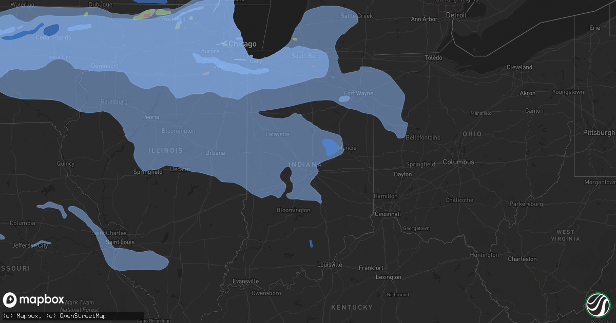
August 10 map
$229
one time, instant access
Download today. No call, no setup
Keep the $229
Bought the map and want the full workflow? Apply the entire $229 to a subscription within 7 days. None of it is wasted.
Every map, not just this one
This buys you this map. Subscription and you get every map we run, in the markets you choose from a few cities to whole states to nationwide. Plus real-time alerts the moment a storm fires.
Contact data
Name, contact info, occupancy, even credit band for addresses in the footprint. You go from where it hit to who to call.
Become the source they trust
Unlimited branding weather history reports on demand. You already have the documented answer ready for the property owner, and you are the one who showed up with it.
Property data and RoofTrace estimates
Pull up any address you have got, its value and the exact code rules for that jurisdiction, straight from One Click Code. Then RoofTrace estimates the squares, pitch, and roof value, priced the way you price.
Storm reports in Indiana
Indiana
| Date | Description |
|---|---|
| 08/10/20206:57 PM CDT | Semi was overturned. |
| 08/10/20206:55 PM CDT | A twelve inch diameter live tree was blown down at its base by thunderstorm winds near 600 w and 700 s. Time approximated from radar. |
| 08/10/20206:50 PM CDT | Approximate location. Receiving reports of trees and power lines and a few shingles and siding off a business in northern anderson and frankton indiana. |
| 08/10/20206:50 PM CDT | Corrects previous tstm wnd dmg report from country club heights. Approximate location. Receiving reports of trees and power lines and a few shingles and siding off a bu |
| 08/10/20206:50 PM CDT | Ten inch diameter live tree broken at cr 800 n and 500 e from thunderstorm wind. |
| 08/10/20206:50 PM CDT | Two 10 to 12 inch down from a live healthy tree. |
| 08/10/20206:47 PM CDT | No damage seen. |
| 08/10/20206:46 PM CDT | Trees were blown down just west of linwood. Time approximate. |
| 08/10/20206:46 PM CDT | A six to eight inch diameter tree was blown down onto utility lines. Line down in yard. Power out. |
| 08/10/20206:45 PM CDT | *** 1 fatal... 1 inj *** mobile home rolled over trapping two occupants... Adult female died later at hospital... Male child in good condition. |
| 08/10/20206:45 PM CDT | A local report indicates 65 MPH wind near 3 WNW HOMECROFT |
| 08/10/20206:45 PM CDT | Eight to ten inch diameter trees or tree limbs were blown down by thunderstorm winds. |
| 08/10/20206:42 PM CDT | Thunderstorm winds have caused power outages in the pendleton area per emergency manager. |
| 08/10/20206:42 PM CDT | Thunderstorm winds have caused over 500 power outages in the anderson area per emergency manager. |
| 08/10/20206:40 PM CDT | Multiple trees and large branches across sr 327 between cr56 and cr64. Time estimated by radar. |
| 08/10/20206:38 PM CDT | Semi blown on its side. |
| 08/10/20206:35 PM CDT | Top half of a 1 foot diameter tree snapped at the intersection of leo road and arapaho passover. |
| 08/10/20206:34 PM CDT | Thunderstorm winds snapped off a 36 inch diameter live tree at its base. Time estimated from radar. |
| 08/10/20206:34 PM CDT | A local report indicates 61 MPH wind near INDIANAPOLIS INT'L AIRP |
| 08/10/20206:33 PM CDT | Over 50 reports of trees and power lines sent to electric companies reported by fire departments...most of which were in anderson...alexandria...and elwood. Time estima |
| 08/10/20206:33 PM CDT | Over 50 reports of trees and power lines sent to electric companies reported by fire departments...most of which were in anderson...alexandria...and elwood. Time estima |
| 08/10/20206:33 PM CDT | Over 50 reports of trees and power lines sent to electric companies reported by fire departments...most of which were in anderson...alexandria...and elwood. Time estima |
| 08/10/20206:33 PM CDT | A pear tree was blown down. |
| 08/10/20206:33 PM CDT | Power pole snapped in lake arrowhead area. Time estimated from radar. |
| 08/10/20206:33 PM CDT | One tree of unknown size was blown down into a house near anderson university by thunderstorm winds. Time approximated from radar. |
| 08/10/20206:32 PM CDT | Estimated 12-18 inch diameter tree was blow down into the road with live power lines down at 4000 block of 00ns howard co. Relayed to ema by citizen. |
| 08/10/20206:32 PM CDT | A local report indicates 69 MPH wind near 2 S ROLLING HILLS |
| 08/10/20206:30 PM CDT | Dispatch reports trees and power lines down in fort wayne. No specific details. |
| 08/10/20206:29 PM CDT | Large tree down and power lines snapped in kendallville. Time estimated from radar. |
| 08/10/20206:28 PM CDT | A tree and power lines were blown down from thunderstorm winds at 200 south and dan jones road. Time approximated from radar. |
| 08/10/20206:25 PM CDT | A large tree limb was blown down that is approximately 8 to 10 inches in diameter. |
| 08/10/20206:23 PM CDT | Numerous large tree branches down onto a house. |
| 08/10/20206:23 PM CDT | Tree downed onto a house. Time estimated from radar. |
| 08/10/20206:23 PM CDT | New barn under construction sustained significant roof and wall damage. Photos on twitter. |
| 08/10/20206:21 PM CDT | Thunderstorm winds blew down a 14 to 16 inch diameter tree across the road near or at county road 625 east and county road 300 south. Time approximated from radar. |
| 08/10/20206:21 PM CDT | Power poles downed. Time estimated from radar. |
| 08/10/20206:21 PM CDT | Estimated 50 to 60 mph winds in brownsburg. Biggest tree limb down nearby is about 3 inches in diameter. |
| 08/10/20206:20 PM CDT | Several trees down blocking road near 900n and 300e. Damage also to a house. Time estimated from radar. |
| 08/10/20206:20 PM CDT | Tree downed onto a house with notable damage to the house. Time estimated from radar. |
| 08/10/20206:20 PM CDT | A tree roughly 18 inches in diameter was snapped off that fell onto utility lines due to thunderstorm winds. Time approximated from radar. |
| 08/10/20206:19 PM CDT | Large trees down on a property. Time estimated from radar. |
| 08/10/20206:19 PM CDT | Metal roof partially taken off of a building. Time estimated from radar. |
| 08/10/20206:18 PM CDT | Tree blown down. |
| 08/10/20206:17 PM CDT | Large tree down. |
| 08/10/20206:16 PM CDT | Corn knocked down in a field. |
| 08/10/20206:16 PM CDT | 25 foot tall tree down across a fence. Trunk snapped 2 or 3 feet from the ground. Time estimated from radar. |
| 08/10/20206:16 PM CDT | Large portion of a tree down. Picture on twitter. |
| 08/10/20206:14 PM CDT | Healthy tree snapped at the base. Photo on twitter. |
| 08/10/20206:14 PM CDT | Empty grain bin toppled. Photo on twitter. |
| 08/10/20206:10 PM CDT | A 25 inch diameter live with significant tree rot was blown down onto a road by thunderstorm winds. |
| 08/10/20206:09 PM CDT | Corrects previous tstm wnd dmg report from battle ground. Numerous trees and limbs down around battle ground. Video and lots of pics of tree damage. Widespread power ou |
| 08/10/20206:08 PM CDT | A tree was blow down by thunderstorm winds. |
| 08/10/20206:07 PM CDT | Power lines down on north side of north webster. |
| 08/10/20206:06 PM CDT | A 12 inch diameter tree limb was blown down by thunderstorm winds at state road 39 and county road 1025 north. Time approximated from radar. |
| 08/10/20206:06 PM CDT | A 10 inch diameter tree was blown down by thunderstorm winds at 550 north maple street. |
| 08/10/20206:06 PM CDT | A live 24 inch diameter tree was blown down by thunderstorm winds at county road 275 east and county road 1000 north. Time estimated from radar. |
| 08/10/20206:05 PM CDT | Reports of trees and power lines down. Time estimated from radar. |
| 08/10/20206:01 PM CDT | A 12 inch diameter tree limb was blown down by thunderstorm winds. |
| 08/10/20206:01 PM CDT | Power outage. |
| 08/10/20206:00 PM CDT | Six to eight inch diameter trees or tree limbs were blown down by thunderstorm winds. Time is approximate. |
| 08/10/20206:00 PM CDT | Tree and power lines down. Time estimated from radar. |
| 08/10/20206:00 PM CDT | An 18 to 24 inch diameter tree downed at the 4000 block of county road 1100s near reelsville. 3 power poles were snapped near the location. Fire rescue made 12 downed t |
| 08/10/20205:59 PM CDT | Duke energy reports 130 power outages to homes or businesses. |
| 08/10/20205:58 PM CDT | Several reports of utility lines down in terre haute. |
| 08/10/20205:58 PM CDT | Widespread tree damage as well as some structure damage from falling trees in the epworth forest area. |
| 08/10/20205:57 PM CDT | Scanner traffic indicates power lines down on south 7th st. In terre haute. |
| 08/10/20205:57 PM CDT | Large tree down. |
| 08/10/20205:56 PM CDT | Nws storm survey concluded ef-1 tornado occurred. Tornado tracked southeast to 1 mile east of north webster before dissipating. Trees were snapped west of state road 13 |
| 08/10/20205:56 PM CDT | Duke energy reports 100 power outages to homes or businesses. |
| 08/10/20205:56 PM CDT | Measured 70 mph wind gust at sr 26 and 750 w in howard co by trained amateur spotter. Relayed by em. |
| 08/10/20205:55 PM CDT | Large tree limbs down in north manchester. Time estimated from radar. |
| 08/10/20205:54 PM CDT | A number of large tree branches down. Branches look healthy in twitter picture. |
| 08/10/20205:54 PM CDT | Multiple large tree limbs down in leesburg. Time estimated from radar. |
| 08/10/20205:51 PM CDT | Estimated 60 to 70 mph wind gusts at fruitridge avenue and plum street on the east side of terre haute. |
| 08/10/20205:51 PM CDT | Two hundred and two homes or businesses without power according to duke energy. |
| 08/10/20205:50 PM CDT | Large tree down on the road. Time estimated from radar. |
| 08/10/20205:50 PM CDT | Large tree branch was down across sr 15. Tree shows some rot. |
| 08/10/20205:50 PM CDT | Power outage. |
| 08/10/20205:48 PM CDT | Large trees down in peru. Time estimated from radar. |
| 08/10/20205:46 PM CDT | Fifty homes or businesses without power. Reported from duke energy. |
| 08/10/20205:45 PM CDT | Neighborhood of northwest woods had three trees downed... Around 1 to 2 ft in diameter. Appeared reasonably healthy. Numerous small to medium sized limbs down... Rangin |
| 08/10/20205:44 PM CDT | Several large trees down in nappanee. Time estimated from radar. |
| 08/10/20205:40 PM CDT | Nws survey confirmed an ef1 tornado on august 11th 2020. |
| 08/10/20205:40 PM CDT | Delayed report of several large trees down in mentone vicinity including a large tree falling on top of a house. |
| 08/10/20205:36 PM CDT | Trees down. |
| 08/10/20205:35 PM CDT | Tree and power line down over road. Via twitter. |
| 08/10/20205:32 PM CDT | Ninety power outages in attica according to duke energy. |
| 08/10/20205:30 PM CDT | A local report indicates 65 MPH wind near 4 SE BURROWS |
| 08/10/20205:30 PM CDT | Trees and power lines down across plymouth area. Time estimated from radar. |
| 08/10/20205:30 PM CDT | Reports of trees down. |
| 08/10/20205:30 PM CDT | Trees and power lines down along with pea sized hail. |
| 08/10/20205:19 PM CDT | A local report indicates 67 MPH wind near 4 SW VEEDERSBURG |
| 08/10/20205:18 PM CDT | A local report indicates 63 MPH wind near LAFAYETTE |
| 08/10/20205:13 PM CDT | Large tree uprooted...roughly 16 inches in diameter. |
| 08/10/20205:10 PM CDT | 1-2 ft diameter tree downed blocking the road on e 400 n near raccoon circle. Delayed report. |
| 08/10/20205:10 PM CDT | Tree across the road with a power line entangled in it. There was another power line downed in town but an exact location was not given. Delayed report. |
| 08/10/20205:10 PM CDT | Trees down across old indiana 25 going into delphi at the carroll and tippecanoe county border going down the hill. Time estimated from radar. |
| 08/10/20205:10 PM CDT | A local report indicates 63 MPH wind near 2 E BREMS |
| 08/10/20205:08 PM CDT | Power line downed at 500n and 700e. Delayed report. |
| 08/10/20205:05 PM CDT | Tree downed across lowes road bridge and blocking traffic... Approximately 1 ft in diameter. Delayed report. |
| 08/10/20205:03 PM CDT | A local report indicates 70 MPH wind near 5 ENE ATTICA |
| 08/10/20205:03 PM CDT | A local report indicates 70 MPH wind near 3 SW CAMDEN |
| 08/10/20204:58 PM CDT | Gust front ahead of approaching line has apparently knocked out electric power. Currently estimated winds at 30-40 mph at the observing site. |
| 08/10/20204:48 PM CDT | Large tree down. Time estimated from radar. |
| 08/10/20204:41 PM CDT | Semi blown over near valparaiso. Time estimated by radar. |
| 08/10/20204:40 PM CDT | Trained spotter reports 10 inch diameter branch downed on lute road in portage. Time estimated by radar. |
| 08/10/20204:40 PM CDT | Damage to the roof of a strip mall along central avenue in portage. Time estimated by radar. |
| 08/10/20204:39 PM CDT | Estimated 70 mph wind gusts. Time estimated by radar. |
| 08/10/20204:32 PM CDT | Four 8 to 10 inch in diameter snapped. |
| 08/10/20204:31 PM CDT | Downed trees and trampoline thrown across yard. |
| 08/10/20204:29 PM CDT | Private weather station recorded 60 mph gust. |
| 08/10/20204:21 PM CDT | 30 by 50 foot corn field flattened with swiling denoted in cornfall. Also... Metal sheds damaged with parts of roofs and doors missing. No major structure damage was no |
| 08/10/20204:21 PM CDT | Brick chimney blown down; multiple tree limbs blown down. Time estimated by radar. |
| 08/10/20204:20 PM CDT | Powerlines down across us-41 near in-16 between morocco and kentland. Time estimated by radar. |
| 08/10/20204:16 PM CDT | Large tree snapped. Time estimated by radar. |
| 08/10/20204:15 PM CDT | Private weather station observed 61 mph gust. |
| 08/10/20204:15 PM CDT | This ef-0 tornado was on the ground for less than 1 minute and produced minor damage to a metal farm building immediately west of state highway 41. |
| 08/10/20204:15 PM CDT | 6 inch diameter tree downed near parrish avenue and 141st avenue in cedar lake. Time estimated by radar. |
| 08/10/20204:08 PM CDT | Several trees snapped. |
| 08/10/20204:55 AM CDT | At 954 PM EDT, a severe thunderstorm was located 12 miles southeast of Salem, moving southeast at 30 mph. HAZARD...60 mph wind gusts. SOURCE...Radar indicated. IMPACT...Expect damage to roofs, siding, and trees. Locations impacted include... New Albany, Clarksville, Sellersburg, Galena, Blue River, New Pekin, Borden, Greenville, Navilleton and Speed. |
| 08/10/20204:24 AM CDT | At 924 PM EDT, a severe thunderstorm was located 9 miles southwest of Salem, moving east at 45 mph. HAZARD...60 mph wind gusts. SOURCE...Radar indicated. IMPACT...Expect damage to roofs, siding, and trees. Locations impacted include... Galena, Blue River, New Pekin, Palmyra, Borden, Greenville, Hardinsburg, Livonia, Fredericksburg and Shorts Corner. |
| 08/10/20204:07 AM CDT | At 907 PM EDT, a severe thunderstorm was located 8 miles northeast of Salem, moving east at 40 mph. HAZARD...60 mph wind gusts. SOURCE...Radar indicated. IMPACT...Expect damage to roofs, siding, and trees. Locations impacted include... Scottsburg, Vienna, Austin, Little York, Kossuth, Plattsburg, New Frankfort and Leota. |
| 08/10/20203:58 AM CDT | At 857 PM EDT, a severe thunderstorm was located over Brownstown, or 12 miles southwest of Seymour, moving east at 35 mph. HAZARD...60 mph wind gusts and penny size hail. SOURCE...Radar indicated. IMPACT...Expect damage to roofs, siding, and trees. Locations impacted include... Seymour, Brownstown, Crothersville, Medora, Vallonia, Pleasant View, Paris Crossing, Freetown and Cortland.This includes Interstate 65 between mile markers 37 and 50. |
| 08/10/20203:36 AM CDT | At 835 PM EDT, a severe thunderstorm was located near St. Henry, moving east at 35 mph. HAZARD...60 mph wind gusts. SOURCE...Radar indicated. IMPACT...Expect damage to trees and power lines. Locations impacted include... Piqua, Greenville, Versailles, Covington, Newport, Bradford, Union City, Fort Loramie, Ansonia, Webster, Russia, Gettysburg, Osgood, North Star, Rossburg, New Weston, Yorkshire, Polo, Darke County Airport and Rose Hill.This includes I-75 in Ohio between mile markers 80 and 83. |
| 08/10/20203:01 AM CDT | At 801 PM EDT, severe thunderstorms were located along a line extending from 9 miles north of Nashville to 12 miles east of Bloomfield, moving southeast at 35 mph. HAZARD...70 mph wind gusts. SOURCE...Radar indicated. IMPACT...Expect considerable tree damage. Damage is likely to mobile homes, roofs, and outbuildings. Locations impacted include... Columbus, Seymour, Bedford, Brownstown, Nashville, Edinburgh, Mitchell, Hope, Crothersville, Oolitic, Medora, Elizabethtown, Hartsville, Clifford, Jonesville, Peoga, Newbern, Smithville, Tunnelton and Gnaw Bone.This includes Interstate 65 between mile markers 37 and 78. |
| 08/10/20202:55 AM CDT | At 754 PM EDT, a severe thunderstorm was located 9 miles southwest of Greenfield, or 12 miles northwest of Shelbyville, moving east at 45 mph. HAZARD...70 mph wind gusts. SOURCE...Radar indicated. IMPACT...Expect considerable tree damage. Damage is likely to mobile homes, roofs, and outbuildings. Locations impacted include... Indianapolis, Shelbyville, Greenwood, Franklin, New Whiteland, Edinburgh, Whiteland, Bargersville, New Palestine, Flat Rock, Princes Lakes, Geneva, Morristown, Trafalgar, St. Paul, Morgantown, Carthage, Fairland, Waldron and Mays.This includes the following highways... Interstate 65 between mile markers 79 and 102. Interstate 74 between mile markers 98 and 123.This storm is producing power outages. |
| 08/10/20202:36 AM CDT | At 735 PM EDT, a severe thunderstorm was located near Lawrence, or 10 miles east of Indianapolis, moving east at 90 mph. HAZARD...70 mph wind gusts. SOURCE...Radar indicated. IMPACT...Expect considerable tree damage. Damage is likely to mobile homes, roofs, and outbuildings. Locations impacted include... Indianapolis, Carmel, Fishers, Lawrence, Greenfield, Beech Grove, Speedway, Cumberland, McCordsville, Pendleton, Fortville, Ingalls, New Palestine, Meridian Hills, Warren Park, Rocky Ripple, Markleville, Wilkinson, Williams Creek and Wynnedale.This includes the following highways... Interstate 65 between mile markers 107 and 120. Interstate 69 between mile markers 200 and 210. Interstate 70 between mile markers 74 and 112. Interstate 74 between mile markers 73 and 96. |
| 08/10/20202:34 AM CDT | At 733 PM EDT, a severe thunderstorm was located 8 miles east of Spencer, or 11 miles northwest of Bloomington, moving east at 45 mph. HAZARD...60 mph wind gusts. SOURCE...Radar indicated. IMPACT...Expect damage to roofs, siding, and trees. Locations impacted include... Bloomington, Spencer, Nashville, Ellettsville, Worthington, Stinesville, Smithville, Lake Lemon, Beanblossom, Gnaw Bone, Freedom, Spurgeons Corner, Monroe Reservoir, Woodville Hills, Elkinsville, Charles Deam Wilderness, Stone Head, Unionville, Story and Whitehall. |
| 08/10/20202:19 AM CDT | At 718 PM EDT, a severe thunderstorm was located near Elwood, or 11 miles northwest of Anderson, moving east at 50 mph. HAZARD...60 mph wind gusts. SOURCE...Radar indicated. IMPACT...Expect damage to roofs, siding, and trees. Locations impacted include... Muncie, Anderson, Fishers, Elwood, Alexandria, Yorktown, Pendleton, Chesterfield, Lapel, Edgewood, Frankton, Eaton, Daleville, Summitville, Gaston, Orestes, Sulphur Springs, Woodlawn Heights, Country Club Heights and River Forest.This includes Interstate 69 between mile markers 210 and 251. |
| 08/10/20202:15 AM CDT | At 715 PM EDT, a severe thunderstorm was located 12 miles east of Greencastle, or 28 miles north of Bloomington, moving east at 40 mph. HAZARD...60 mph wind gusts. SOURCE...Radar indicated. IMPACT...Expect damage to roofs, siding, and trees. Locations impacted include... Indianapolis, Greenwood, Plainfield, Franklin, Beech Grove, Martinsville, Greencastle, Mooresville, Southport, New Whiteland, Edinburgh, Whiteland, Bargersville, Cloverdale, Brooklyn, Princes Lakes, Trafalgar, Monrovia, Morgantown and Clayton.This includes the following highways... Interstate 65 between mile markers 84 and 106. Interstate 70 between mile markers 35 and 72. Interstate 74 between mile markers 98 and 100. |
| 08/10/20202:04 AM CDT | At 703 PM EDT, a severe thunderstorm was located 7 miles northeast of Lebanon, or 15 miles southeast of Frankfort, moving east at 45 mph. HAZARD...70 mph wind gusts. SOURCE...Radar indicated. IMPACT...Expect considerable tree damage. Damage is likely to mobile homes, roofs, and outbuildings. Locations impacted include... Indianapolis, Carmel, Fishers, Noblesville, Lawrence, Plainfield, Brownsburg, Lebanon, Beech Grove, Zionsville, Speedway, Danville, Westfield, Avon, Cicero, Pittsboro, Whitestown, Sheridan, Arcadia and Meridian Hills.This includes the following highways... Interstate 65 between mile markers 107 and 138. Interstate 69 between mile markers 200 and 209. Interstate 70 between mile markers 73 and 91. Interstate 74 between mile markers 59 and 94.This storm is producing power outages. |
| 08/10/20201:48 AM CDT | At 648 PM EDT, severe thunderstorms were located along a line extending from 7 miles northwest of North Manchester to 6 miles northeast of Mexico, moving east at 45 mph. HAZARD...60 mph wind gusts. SOURCE...Radar indicated. IMPACT...Expect damage to roofs, siding, and trees. Severe thunderstorms will be near... North Manchester around 655 PM EDT. Wabash around 700 PM EDT. South Whitley around 705 PM EDT. Andrews around 720 PM EDT. Huntington around 725 PM EDT.This includes Interstate 69 in Indiana near mile marker 284. |
| 08/10/20201:42 AM CDT | At 641 PM EDT, a severe thunderstorm was located 8 miles northwest of Frankfort, moving east at 50 mph. HAZARD...60 mph wind gusts. SOURCE...Radar indicated. IMPACT...Expect damage to roofs, siding, and trees. Locations impacted include... Kokomo, Frankfort, Tipton, Windfall, Greentown, Rossville, Mulberry, Russiaville, Kirklin, Colfax, Sharpsville, Burlington, Michigantown, Kempton and Indian Heights.This includes Interstate 65 between mile markers 151 and 160.This storm is producing power outages. |
| 08/10/20201:27 AM CDT | At 626 PM EDT, a severe thunderstorm was located near Crawfordsville, moving east at 60 mph. HAZARD...70 mph wind gusts. SOURCE...Radar indicated. IMPACT...Expect considerable tree damage. Damage is likely to mobile homes, roofs, and outbuildings. Locations impacted include... Crawfordsville, Brownsburg, Lebanon, Pittsboro, Thorntown, Ladoga, Jamestown, Darlington, Linden, New Market, North Salem, Lizton, Advance, Waveland, New Ross, Ulen, Alamo and Shades State Park.This includes the following highways... Interstate 65 between mile markers 133 and 150. Interstate 74 between mile markers 27 and 64. |
| 08/10/20201:24 AM CDT | At 623 PM EDT, severe thunderstorms were located along a line extending from near Dowagiac to near South Bend to near Plymouth to Argos, moving east at 45 mph. These are very dangerous storms. HAZARD...80 mph wind gusts and quarter size hail. SOURCE...Radar indicated. IMPACT...Flying debris will be dangerous to those caught without shelter. Mobile homes will be heavily damaged. Expect considerable damage to roofs, windows, and vehicles. Extensive tree damage and power outages are likely. Severe thunderstorms will be near... Mishawaka and Dowagiac around 630 PM EDT. Bremen, Granger, Bourbon and Cassopolis around 635 PM EDT. Osceola and Mentone around 640 PM EDT. Elkhart, Simonton Lake, Wakarusa and Marcellus around 645 PM EDT. Nappanee and Dunlap around 650 PM EDT. Warsaw, Winona Lake, Bristol, Milford and New Paris around 655 PM EDT. Goshen, Three Rivers, Syracuse and Pierceton around 700 PM EDT. Middlebury, Centreville, North Webster and Millersburg around 705 PM EDT.This includes Interstate 80 in Indiana between mile markers 73 and124. |
| 08/10/20201:15 AM CDT | At 614 PM EDT, a severe thunderstorm was located 8 miles east of Lafayette, moving east at 55 mph. HAZARD...70 mph wind gusts. SOURCE...Radar indicated. IMPACT...Expect considerable tree damage. Damage is likely to mobile homes, roofs, and outbuildings. Locations impacted include... Lafayette, Kokomo, Frankfort, West Lafayette, Tipton, Delphi, Flora, Rossville, Shadeland, Dayton, Mulberry, Russiaville, Kirklin, Colfax, Camden, Clarks Hill, Sharpsville, Burlington, Michigantown and Kempton.This includes Interstate 65 between mile markers 151 and 176. |
| 08/10/202012:49 AM CDT | At 549 PM EDT, a severe thunderstorm was located over Danville, moving east at 60 mph. HAZARD...70 mph wind gusts. SOURCE...Radar indicated. IMPACT...Expect considerable tree damage. Damage is likely to mobile homes, roofs, and outbuildings. Locations impacted include... Crawfordsville, Covington, Veedersburg, Cayuga, Waynetown, Darlington, Linden, New Market, Hillsboro, Kingman, Perrysville, New Richmond, Wingate, Newtown, Mellott, Wallace, Alamo, Foster, Yeddo and Gessie.This includes Interstate 74 between mile markers 1 and 39. |
| 08/10/202012:27 AM CDT | At 527 PM EDT, a severe thunderstorm was located near Talbot, moving east at 60 mph. HAZARD...70 mph wind gusts. SOURCE...Radar indicated. IMPACT...Expect considerable tree damage. Damage is likely to mobile homes, roofs, and outbuildings. Locations impacted include... Lafayette, West Lafayette, Delphi, Williamsport, Attica, Shadeland, Dayton, Battle Ground, West Lebanon, Pine Village, Yeoman, Purdue University, Pence, Tab and Rainsville.This includes Interstate 65 between mile markers 164 and 183. |
| 08/10/202012:22 AM CDT | At 522 PM EDT/422 PM CDT/, severe thunderstorms were located along a line extending from near Conrad to Brook to near Raub, moving east at 50 mph. These are very dangerous storms. HAZARD...80 mph wind gusts and quarter size hail. SOURCE...Radar indicated. IMPACT...Flying debris will be dangerous to those caught without shelter. Mobile homes will be heavily damaged. Expect considerable damage to roofs, windows, and vehicles. Extensive tree damage and power outages are likely. Severe thunderstorms will be near... Wolcott around 550 PM EDT. Monon and Medaryville around 555 PM EDT. Monticello, Brookston and Francesville around 600 PM EDT. Winamac and Royal Center around 615 PM EDT. Logansport around 630 PM EDT. Rochester and Walton around 640 PM EDT. Peru, Grissom Afb and Mexico around 645 PM EDT. Bunker Hill around 650 PM EDT.This includes Interstate 65 between mile markers 185 and 198. |
| 08/10/202012:19 AM CDT | At 517 PM EDT/417 PM CDT/, severe thunderstorms were located along a line extending from 16 miles northeast of Hyde Park to near Gary to near Crown Point to near Lake Village, moving east at 55 mph. These are very dangerous storms. HAZARD...80 mph wind gusts and quarter size hail. SOURCE...Radar indicated. IMPACT...Flying debris will be dangerous to those caught without shelter. Mobile homes will be heavily damaged. Expect considerable damage to roofs, windows, and vehicles. Extensive tree damage and power outages are likely. Severe thunderstorms will be near... Wanatah and La Crosse around 540 PM EDT. Westville and Trail Creek around 545 PM EDT. New Buffalo and Kingsford Heights around 550 PM EDT. La Porte, Knox, Bridgman, North Judson, Three Oaks, Hamlet, Shorewood-Tower Hills-Harbert and Shorewood-Tower Hill around 555 PM EDT. Stevensville around 600 PM EDT. Buchanan, Walkerton, New Carlisle and Koontz Lake around 605 PM EDT. Plymouth, North Liberty and Berrien Springs around 610 PM EDT. South Bend, Niles and Culver around 615 PM EDT.This includes the following highways... Interstate 196 between mile markers 0 and 7. Interstate 80 in Indiana between mile markers 38 and 87. Interstate 94 in Indiana between mile markers 33 and 45. Interstate 94 in Michigan between mile markers 0 and 42. |
| 08/10/202012:16 AM CDT | At 515 PM CDT, severe thunderstorms were located along a line extending from near Charleston to near Ramsey, moving southeast at 25 mph. HAZARD...60 mph wind gusts. SOURCE...Radar indicated. IMPACT...Expect damage to roofs, siding, and trees. Locations impacted include... Charleston, Mattoon, Effingham, Robinson, Newton, Toledo, Casey, Altamont, Neoga, Teutopolis, Greenup, Oblong, Watson, Stewardson, Dieterich, Hutsonville, Beecher City, Edgewood, Lerna and Ste. Marie.This includes the following highways... Interstate 57 between mile markers 144 and 185. Interstate 70 between mile markers 79 and 126. |
| 08/09/202011:55 PM CDT | At 454 PM CDT, severe thunderstorms were located along a line extending from near Belgium to near Oakland, moving southeast at 55 mph. HAZARD...60 mph wind gusts. SOURCE...Radar indicated. IMPACT...Expect damage to roofs, siding, and trees. Locations impacted include... Paris, Marshall, Casey, Chrisman, Martinsville, Oakland, Kansas, Ashmore, Westfield, Hume, Brocton, Vermilion, Redmon, Clarksville, Oliver, Dennison, West Union, Edgar, Darwin and Orange.This includes Interstate 70 between mile markers 128 and 154. |
| 08/09/202010:32 PM CDT | At 331 PM CDT, a severe thunderstorm was located 23 miles northwest of Long Beach, or 24 miles northwest of Michigan City, moving east at 75 mph. This is a very dangerous storm. HAZARD...80 mph wind gusts and quarter size hail. SOURCE...Trained weather spotters. IMPACT...Flying debris will be dangerous to those caught without shelter. Mobile homes will be heavily damaged. Expect considerable damage to roofs, windows, and vehicles. Extensive tree damage and power outages are likely. Locations impacted include... Chicago, Aurora, Joliet, Naperville, Elgin, Waukegan, Cicero, Hammond, Arlington Heights, Evanston, Schaumburg, Bolingbrook, Palatine, Skokie, Des Plaines, Orland Park, Tinley Park, Oak Lawn, Berwyn and Mount Prospect.Including the following interstates... I-55 between mile markers 233 and 294. I-57 between mile markers 303 and 358. I-80 between mile markers 123 and 155. I-88 between mile markers 121 and 140. I-90 between mile markers 57 and 107. I-94 between mile markers 1 and 74. I-290 between mile markers 1 and 29. I-294 between mile markers 1 and 74. I-355 between mile markers 1 and 30. Indiana I-90 between mile markers 1 and 2. |
| 08/09/202010:31 PM CDT | At 330 PM CDT/430 PM EDT/, a severe thunderstorm was located near Herscher, moving east at 55 mph. HAZARD...70 mph wind gusts. SOURCE...Radar indicated. IMPACT...Expect considerable tree damage. Damage is likely to mobile homes, roofs, and outbuildings. Locations impacted include... Hammond, Gary, Portage, Merrillville, Valparaiso, East Chicago, Schererville, Hobart, Lansing, Crown Point, Highland, Munster, Chesterton, Cedar Lake, Lowell, Rensselaer, DeMotte, Hebron, Fowler and Kentland.Including the following interstates... Indiana I-80 between mile markers 1 and 16. Indiana I-90 between mile markers 3 and 37. Indiana I-94 between mile markers 16 and 32. Indiana I-65 between mile markers 200 and 261.This includes... Indiana University Northwest, Purdue UniversityNorthwest Hammond, Valparaiso University, Illiana Motor Speedway,Indiana Dunes State Park, Lake County Fairgrounds, Porter CountyFairgrounds, South Shore Rail Cats Baseball, and US 41 Dragway. |
| 08/09/20209:56 PM CDT | At 254 PM CDT, a line of severe thunderstorms were located along a line from Rockford to Mendota, moving east at 75 mph. This is a very dangerous storm! HAZARD...80 mph wind gusts and quarter size hail. SOURCE...Trained weather spotters. This storm has a history of producing widespread wind damage across western and north central Illinois. IMPACT...Flying debris will be dangerous to those caught without shelter. Mobile homes will be heavily damaged. Expect considerable damage to roofs, windows, and vehicles. Extensive tree damage and power outages are likely. Locations impacted include... Chicago, Aurora, Joliet, Naperville, Elgin, Waukegan, Cicero, Hammond, Arlington Heights, Evanston, Schaumburg, Bolingbrook, Palatine, Skokie, Des Plaines, Orland Park, Tinley Park, Oak Lawn, Berwyn and Mount Prospect.Including the following interstates... I-55 between mile markers 233 and 294. I-57 between mile markers 303 and 358. I-80 between mile markers 123 and 155. I-88 between mile markers 121 and 140. I-90 between mile markers 57 and 107. I-94 between mile markers 1 and 74. I-290 between mile markers 1 and 29. I-294 between mile markers 1 and 74. I-355 between mile markers 1 and 30. Indiana I-90 between mile markers 1 and 2.This includes... Argonne National Laboratory, Brookfield Zoo,Lincoln Park Zoo, Loyola University, Oakton Community College,Schaumburg Boomers Baseball, SeatGeek Stadium, Triton College,University of Chicago, University of St. Francis, Windy CityThunderbolts Baseball, Benedictine University, Chain O Lakes StatePark, Channahon State Park, Chicagoland Speedway...Route 66 Raceway,College of DuPage, College of Lake County, DuPage County Fairgrounds,Hollywood Casino Amphitheatre, Governors State University, GreatLakes Naval Training Center, Harper College, Hawthorne Park, JolietJunior College, Joliet Slammers Baseball, Kankakee Community College,Kankakee County Fairgrounds and Speedway, Kankakee River State Park,Lake County IL Fairgrounds, Lake Forest College, Lewis University,Moraine Valley Community College, Morton Arboretum, NortheasternIllinois University, Northwestern University, Olivet NazarineUniversity, Prairie State College, Ravinia Music Festival, Six FlagsGreat America, Soldier Field, South Suburban College, University ofIllinois Chicago, Guaranteed Rate Field...IL Institute of Technology,Wheaton College, Will County Fairgrounds, Wrigley Field, The Loop,Museum of Science and Industry, Museum Campus, Northerly Island, andNorth Central College. |
| 08/09/20208:18 PM CDT | Numerous trees and several power lines down across jackson county. Time estimated from radar. |
| 08/09/20208:05 PM CDT | Trees down near intersection of walnut ridge rd and north mckinley road. |
| 08/09/20207:48 PM CDT | Twelve inch diameter tree limbs were blown down from thunderstorm winds. |
| 08/09/20207:48 PM CDT | A tree approximately 18 inches in diameter was blown down by thunderstorm winds. Time is approximated from radar. |
| 08/09/20207:30 PM CDT | Numerous trees down. |
| 08/09/20207:30 PM CDT | Scattered power outages have occurred from thunderstorm wind damage. |
| 08/09/20207:30 PM CDT | Scattered power outages have occurred from thunderstorm wind damage in hope. |
| 08/09/20207:26 PM CDT | Numerous trees and limbs down around battle ground. Video and lots of pics of tree damage. Widespread power outages from battle ground to burrows reported with much of |
| 08/09/20207:23 PM CDT | A local report indicates 60 MPH wind near 1 NE EDINBURGH |
| 08/09/20207:19 PM CDT | At 100 north and apple street there are several 10 to 12 inch diameter live tree limbs down from thunderstorm winds. |
| 08/09/20207:05 PM CDT | Trees down into power lines at beech tree and nineveh. Time estimated from radar. 18 other reports of trees down across brown county. |
All States Impacted by Hail Map on August 10, 2020
Cities Impacted by Hail Map on August 10, 2020
- Marienthal, KS
- Holcomb, KS
- Deerfield, KS
- Buffalo, OK
- Rosston, OK
- Englewood, KS
- Ashland, KS
- Cherryvale, KS
- Altamont, KS
- Parsons, KS
- Hazelton, KS
- Burlington, OK
- Waldron, KS
- Kiowa, KS
- Garden City, KS
- Scott City, KS
- Healy, KS
- Wright, KS
- Dodge City, KS
- Jetmore, KS
- Spearville, KS
- Hanston, KS
- La Crosse, KS
- Bison, KS
- McCracken, KS
- Brownell, KS
- Victoria, KS
- Hays, KS
- Ford, KS
- Minneola, KS
- Plains, KS
- Dorrance, KS
- Bunker Hill, KS
- Russell, KS
- Hudson, KS
- Raymond, KS
- Holyrood, KS
- Lorraine, KS
- Ellsworth, KS
- Conway Springs, KS
- Argonia, KS
- Waseca, MN
- New Richland, MN
- Pemberton, MN
- Mapleton, MN
- Janesville, MN
- Ellendale, MN
- Minnesota Lake, MN
- Waldorf, MN
- Centerview, MO
- Bates City, MO
- Otterville, MO
- Holden, MO
- Sedalia, MO
- Kingsville, MO
- Franklin, MO
- Higginsville, MO
- Warrensburg, MO
- Knob Noster, MO
- Boonville, MO
- Chilhowee, MO
- Concordia, MO
- Houstonia, MO
- Mayview, MO
- Pilot Grove, MO
- Nelson, MO
- Tipton, MO
- Smithton, MO
- Whiteman Air Force Base, MO
- Syracuse, MO
- Clarksburg, MO
- Blackburn, MO
- Odessa, MO
- Hughesville, MO
- Bunceton, MO
- Sweet Springs, MO
- Leeton, MO
- Blackwater, MO
- Marshall, MO
- La Monte, MO
- Mora, MO
- Cole Camp, MO
- Florence, MO
- Rush Hill, MO
- Thompson, MO
- Montgomery City, MO
- Wellsville, MO
- Mexico, MO
- Centralia, MO
- Laddonia, MO
- Vandalia, MO
- Middletown, MO
- Farber, MO
- Galt, MO
- Humphreys, MO
- Chillicothe, MO
- Chula, MO
- Trenton, MO
- Browning, MO
- Laredo, MO
- Jefferson City, MO
- Holts Summit, MO
- Bonnots Mill, MO
- Chamois, MO
- Tebbetts, MO
- Lake Saint Louis, MO
- Moscow Mills, MO
- Red Bud, IL
- Festus, MO
- Eolia, MO
- Prairie Du Rocher, IL
- Lenzburg, IL
- Eureka, MO
- Wildwood, MO
- Baldwin, IL
- Ashley, IL
- Herculaneum, MO
- Saint Libory, IL
- New Baden, IL
- Imperial, MO
- Hillsboro, MO
- Smithton, IL
- Troy, MO
- Ballwin, MO
- Arnold, MO
- Wentzville, MO
- Columbia, IL
- Mascoutah, IL
- East Carondelet, IL
- Old Monroe, MO
- Marissa, IL
- Fults, IL
- O'Fallon, MO
- Waterloo, IL
- Tamaroa, IL
- Belleville, IL
- Chesterfield, MO
- Millstadt, IL
- Winfield, MO
- Richview, IL
- Sparta, IL
- Oakdale, IL
- Okawville, IL
- Elsberry, MO
- High Ridge, MO
- Saint Peters, MO
- Nashville, IL
- Barnhart, MO
- House Springs, MO
- Defiance, MO
- Hecker, IL
- Coulterville, IL
- Addieville, IL
- Pevely, MO
- Hawk Point, MO
- Freeburg, IL
- Valley Park, MO
- Pinckneyville, IL
- Fenton, MO
- New Athens, IL
- Silex, MO
- Crystal City, MO
- Dupo, IL
- Valmeyer, IL
- Saint Charles, MO
- Tilden, IL
- Bowling Green, MO
- Du Bois, IL
- Evansville, IL
- Saint Louis, MO
- El Dorado Springs, MO
- Bolivar, MO
- Flemington, MO
- Polk, MO
- Freeport, IL
- Dakota, IL
- Lena, IL
- Kent, IL
- Stockton, IL
- Rock City, IL
- McConnell, IL
- Pearl City, IL
- Cedarville, IL
- Rockford, IL
- Winnebago, IL
- Rockton, IL
- Ridott, IL
- Davis, IL
- Pecatonica, IL
- Durand, IL
- Davis Junction, IL
- Belvidere, IL
- Cherry Valley, IL
- Monroe Center, IL
- Garden Prairie, IL
- Marengo, IL
- Morris, IL
- Lombard, IL
- Glen Ellyn, IL
- Villa Park, IL
- Oak Brook, IL
- Elmhurst, IL
- Stratford, TX
- Dalhart, TX
- Vega, TX
- Spearman, TX
- Gruver, TX
- Perryton, TX
- Hereford, TX
- Canyon, TX
- Dimmitt, TX
- Happy, TX
- Tulia, TX
- Adrian, TX
- Wildorado, TX
- Sudan, TX
- Borger, TX
- Skellytown, TX
- Panhandle, TX
- Pampa, TX
- Miami, TX
- Lohrville, IA
- Carroll, IA
- Odebolt, IA
- Glidden, IA
- Lanesboro, IA
- Auburn, IA
- Kiron, IA
- Battle Creek, IA
- Lake City, IA
- Breda, IA
- Wall Lake, IA
- Arthur, IA
- Ida Grove, IA
- Churdan, IA
- Vail, IA
- Charter Oak, IA
- Arion, IA
- Manilla, IA
- Manning, IA
- Ute, IA
- Dunlap, IA
- Westside, IA
- Dow City, IA
- Mapleton, IA
- Denison, IA
- Coon Rapids, IA
- Scranton, IA
- Jefferson, IA
- Cascade, IA
- Bernard, IA
- Parnell, IA
- Alexandria, IN
- Griffith, IN
- Zearing, IA
- Le Claire, IA
- New Buffalo, MI
- Reddick, IL
- Stillman Valley, IL
- Huxley, IA
- Maple Park, IL
- Wren, OH
- Kimmell, IN
- Princeville, IL
- Crescent City, IL
- Tampico, IL
- Soldier, IA
- Elmwood Park, IL
- Bristol, IL
- Loda, IL
- Slater, IA
- New Goshen, IN
- Forest City, IL
- Spencerville, IN
- Osceola, IN
- Tolono, IL
- Harlan, IA
- Carman, IL
- Macy, NE
- Yates City, IL
- Alvin, IL
- Newtown, IN
- Hills, IA
- Lawndale, IL
- Groveland, IL
- Grovertown, IN
- Lost Nation, IA
- Kewanna, IN
- Evergreen Park, IL
- Bloomingdale, IN
- Berkeley, IL
- Davenport, IA
- Lake View, IA
- Garwin, IA
- Caledonia, WI
- Irwin, IA
- University Park, IL
- Wayne, IL
- Springville, IA
- Morocco, IN
- Delavan, IL
- Homestead, IA
- Sheridan, IL
- Mooseheart, IL
- Franklin Grove, IL
- Creve Coeur, IL
- Mark Center, OH
- Batavia, IL
- Edgerton, OH
- Galien, MI
- Woodhull, IL
- Urbandale, IA
- Windfall, IN
- Round Lake, IL
- Emington, IL
- Saunemin, IL
- Pine Village, IN
- Magnolia, IA
- Russiaville, IN
- Worth, IL
- Aspinwall, IA
- Reinbeck, IA
- Grundy Center, IA
- Marne, IA
- Alamo, IN
- Cedar, IA
- Bartlett, IL
- Wapella, IL
- Chebanse, IL
- Hebron, IL
- Olds, IA
- Danville, IA
- Papineau, IL
- Stevensville, MI
- Ely, IA
- Independence, IA
- Stuart, IA
- Kenosha, WI
- Park Ridge, IL
- Spring Valley, IL
- Little York, IL
- Whitestown, IN
- Kalamazoo, MI
- Caledonia, IL
- Pleasant Prairie, WI
- Brookston, IN
- Grinnell, IA
- Williamsville, IL
- London Mills, IL
- Yeoman, IN
- Stone Park, IL
- Boswell, IN
- Walkerton, IN
- Lemont, IL
- Hudson, IA
- Cuba, IL
- Grand Ridge, IL
- Westpoint, IN
- Seneca, IL
- Thornton, IL
- Payne, OH
- Maywood, IL
- Fair Oaks, IN
- Great Lakes, IL
- Roberts, IL
- Veedersburg, IN
- Oswego, IL
- Crystal Lake, IL
- Staunton, IN
- Decatur, MI
- Grover Hill, OH
- Laura, IL
- Westchester, IL
- Jones, MI
- Clinton, WI
- Willshire, OH
- Marshalltown, IA
- Gladbrook, IA
- New Bremen, OH
- Kinsman, IL
- Emerson, IA
- Eldon, IA
- Palatine, IL
- Hanna City, IL
- New Windsor, IL
- Coloma, MI
- Gridley, IL
- Keswick, IA
- Manteno, IL
- Walnut, IL
- Marshall, IN
- Cambridge, IA
- Conroy, IA
- Spragueville, IA
- Kelley, IA
- Grand Junction, MI
- Muncie, IN
- Waterloo, NE
- Paxton, IL
- Mansfield, IL
- Lafayette, IN
- Manchester, IA
- Greencastle, IN
- Moscow, IA
- Crawfordsville, IA
- Morton Grove, IL
- Somonauk, IL
- Sherwood, OH
- Kalida, OH
- Clarence, IA
- Stanwood, IA
- North Sioux City, SD
- Monroe, IN
- Sheffield, IL
- Fowler, IN
- Constantine, MI
- Wilmette, IL
- Royal, IL
- Ferguson, IA
- Roachdale, IN
- Easton, IL
- Saint Joe, IN
- Taylor Ridge, IL
- Clemons, IA
- Riverside, IA
- River Grove, IL
- Coggon, IA
- Arlington Heights, IL
- Boone, IA
- Kirkville, IA
- Botkins, OH
- Emden, IL
- Shipshewana, IN
- Oakwood, IL
- Wanatah, IN
- Oneida, IL
- Yorkville, IL
- Solon, IA
- Cicero, IL
- Lexington, IL
- La Motte, IA
- Momence, IL
- Paragon, IN
- Craig, NE
- Monroe, IA
- Baroda, MI
- Mount Carroll, IL
- Altona, IL
- Buffalo Grove, IL
- Cary, IL
- Yutan, NE
- Bellevue, IA
- Gilson, IL
- Delta, IA
- Lima, OH
- Bourbon, IN
- Defiance, OH
- Verona, IL
- Panora, IA
- Minonk, IL
- Johnston, IA
- Eureka, IL
- Keota, IA
- Griswold, IA
- Rio, IL
- Cedar Rapids, IA
- Genoa, IL
- Capron, IL
- Lockridge, IA
- Arthur, IL
- Thomasboro, IL
- Osco, IL
- Serena, IL
- Hornick, IA
- Keithsburg, IL
- Colfax, IA
- Wilton, IA
- Fairfield, IA
- Harper, IA
- Council Bluffs, IA
- Lidderdale, IA
- Springfield, NE
- Fox Lake, IL
- Rippey, IA
- Dixon, IA
- New Haven, IN
- La Salle, IL
- Bouton, IA
- Chicago Heights, IL
- Arcola, IL
- Kokomo, IN
- Shelby, IN
- East Moline, IL
- Oxford, IA
- Wapello, IA
- Hometown, IL
- Waynetown, IN
- Bainbridge, IN
- Markle, IN
- Avilla, IN
- Genoa City, WI
- Pesotum, IL
- Elliott, IL
- Le Roy, IL
- Hayesville, IA
- Milford, IL
- Plano, IL
- Olin, IA
- Toulon, IL
- Homewood, IL
- Willowbrook, IL
- Mitchellville, IA
- Climax, MI
- Algonquin, IL
- Smithland, IA
- Buffalo, IL
- Durant, IA
- Danvers, IL
- Wakarusa, IN
- Bloomingdale, IL
- West Brooklyn, IL
- Tipton, IN
- Lovilia, IA
- Coatesville, IN
- Oakford, IL
- Andover, IL
- Maroa, IL
- Ludlow, IL
- McClelland, IA
- Toddville, IA
- Mount Auburn, IA
- Hooper, NE
- Piper City, IL
- Chesterton, IN
- Addison, IL
- La Place, IL
- Georgetown, IL
- Yale, IA
- Perrysville, IN
- New Bedford, IL
- Lane, IL
- Minooka, IL
- Preston, IA
- Arrowsmith, IL
- Columbus Junction, IA
- Pekin, IL
- Lawton, MI
- Barrington, IL
- Ladoga, IN
- Wataga, IL
- South Wilmington, IL
- New Ross, IN
- Mount Pleasant, IA
- North Aurora, IL
- Bremen, IN
- Dalzell, IL
- Larwill, IN
- East Galesburg, IL
- Blakesburg, IA
- New Troy, MI
- Van Wert, OH
- Newton, IA
- Goshen, IN
- Wellington, IL
- Hickory Hills, IL
- Canton, IL
- Mount Pulaski, IL
- Monmouth, IL
- Saint Joseph, MI
- Pleasant Valley, IA
- Bettendorf, IA
- Lacona, IA
- Whitten, IA
- Park Forest, IL
- Winthrop Harbor, IL
- Hoopeston, IL
- North English, IA
- Lovington, IL
- Springfield, IL
- Randall, IA
- Russellville, IN
- Spencerville, OH
- Monterey, IN
- Lowden, IA
- Rensselaer, IN
- Kellogg, IA
- Metcalf, IL
- White Heath, IL
- Newhall, IA
- Loves Park, IL
- Lincolnwood, IL
- Des Plaines, IL
- Milmine, IL
- Fairview, IL
- Hillside, IL
- Allegan, MI
- Rossville, IL
- Oak Lawn, IL
- Hindsboro, IL
- Carlock, IL
- Melrose Park, IL
- Saint Anne, IL
- Elliott, IA
- Mahomet, IL
- North Liberty, IA
- Erie, IL
- Ira, IA
- Avoca, IA
- Kilbourne, IL
- Underwood, IA
- Waynesville, IL
- Bensenville, IL
- Marion, IA
- Dana, IN
- Cutler, IN
- Brazil, IN
- Washington, IA
- Brook, IN
- Linden, IA
- Beverly Shores, IN
- West Chester, IA
- Summit Argo, IL
- Indianola, IA
- Clinton, IN
- Pella, IA
- Bancroft, NE
- Guernsey, IA
- Ackworth, IA
- Westfield, IN
- Wilmot, WI
- Winfield, IA
- Emerson, NE
- Blue Island, IL
- Robbins, IL
- Gifford, IL
- Dubuque, IA
- Camargo, IL
- Naperville, IL
- Kingsford Heights, IN
- Hubbard, NE
- Franklin Park, IL
- Cloverdale, IN
- Sodus, MI
- Waveland, IN
- Elkhart, IN
- Bloomington, IL
- Sac City, IA
- Churubusco, IN
- Wilmington, IL
- Rochelle, IL
- Magnolia, IL
- Milo, IA
- Winfield, IL
- Glasford, IL
- Dundee, IL
- Martinsburg, IA
- Tallula, IL
- Little Sioux, IA
- Donahue, IA
- Farnhamville, IA
- Hartsburg, IL
- Dixon, IL
- Lowpoint, IL
- Big Rock, IL
- Dekalb, IL
- Venedocia, OH
- Tekamah, NE
- Zionsville, IN
- Story City, IA
- Craigville, IN
- Letts, IA
- Winnebago, NE
- Central City, IA
- Cabery, IL
- Oquawka, IL
- West Chicago, IL
- West Des Moines, IA
- Cushing, IA
- Bennett, IA
- Wheatfield, IN
- Battle Creek, MI
- Putnamville, IN
- Palos Heights, IL
- Brandon, IA
- Chicago, IL
- Bagley, IA
- Louisville, NE
- Deep River, IA
- Bondville, IL
- Clarks Hill, IN
- Exira, IA
- Glenview, IL
- Joy, IL
- Scott, OH
- Danbury, IA
- Posen, IL
- Norwalk, IA
- Bismarck, IL
- Treynor, IA
- Bringhurst, IN
- Berrien Center, MI
- De Witt, IA
- Danville, IN
- Polk City, IA
- Sully, IA
- Lone Tree, IA
- Newman, IL
- Dover, IL
- Raymond, IA
- Olympia Fields, IL
- Evansdale, IA
- Brooklyn, IN
- Gilman, IL
- Gibson City, IL
- Fishers, IN
- Mossville, IL
- Persia, IA
- Clutier, IA
- Chillicothe, IA
- Rolling Prairie, IN
- Dallas Center, IA
- Oakwood, OH
- Lincolnshire, IL
- Waterford, WI
- Urbana, IA
- Chenoa, IL
- Sibley, IL
- Center Junction, IA
- Traer, IA
- Dedham, IA
- Garrett, IN
- Hickory Corners, MI
- Bridgman, MI
- Bonfield, IL
- Fremont, IA
- Trafalgar, IN
- Colfax, IN
- Eldridge, IA
- McCallsburg, IA
- La Rose, IL
- Knox, IN
- Elk Horn, IA
- Grayslake, IL
- Sadorus, IL
- Rhodes, IA
- Lynnville, IA
- Paw Paw, MI
- Minburn, IA
- Lakeville, IN
- Hamilton, IA
- Brimfield, IL
- Oakland, IL
- Oglesby, IL
- Kingston, IL
- Dana, IL
- Burlington, IA
- Searsboro, IA
- Mineral, IL
- Wheatland, IA
- Seaton, IL
- Clifton, IL
- Gosport, IN
- Huntley, IL
- Havana, IL
- Ligonier, IN
- Conrad, IA
- Young America, IN
- Henderson, IA
- Congerville, IL
- Onslow, IA
- Hedrick, IA
- Midlothian, IL
- Wood Dale, IL
- Crestwood, IL
- Spring Grove, IL
- Glenwood, IL
- Steger, IL
- Wenona, IL
- Trevor, WI
- Lawrence, MI
- Braceville, IL
- Philo, IL
- Hanover, IL
- Mount Morris, IL
- Riverside, IL
- Columbia City, IN
- Illinois City, IL
- Hennepin, IL
- Lapel, IN
- Universal, IN
- Dewey, IL
- Greentown, IN
- Hooppole, IL
- Winamac, IN
- Broadview, IL
- Adel, IA
- Saint Charles, IL
- Daleville, IN
- Worthington, IA
- Lebanon, IN
- Hinckley, IL
- Tuscola, IL
- Hazel Crest, IL
- Watseka, IL
- Carson, IA
- Smithshire, IL
- Oakland, IA
- Cisco, IL
- Climbing Hill, IA
- Princeton, IA
- Cassopolis, MI
- Middletown, IL
- Princeton, IL
- Sioux City, IA
- Michigan City, IN
- Red Oak, IA
- Catlin, IL
- Watkins, IA
- Brighton, IA
- Tracy, IA
- Williamsport, IN
- Schneider, IN
- Saint John, IN
- Speer, IL
- Bristol, IN
- Sloan, IA
- Rockford, OH
- Bondurant, IA
- Hamlet, IN
- Cissna Park, IL
- Prole, IA
- Silver Lake, WI
- Cantrall, IL
- Decatur, NE
- Gobles, MI
- Adair, IA
- Rose Hill, IA
- Middletown, IA
- Middlebury, IN
- Logan, IA
- Atlantic, IA
- Fithian, IL
- Northbrook, IL
- Hopkinton, IA
- Roselle, IL
- Pleasantville, IA
- Pilot Mound, IA
- Forest Park, IL
- Hobart, IN
- Welton, IA
- Reelsville, IN
- Pender, NE
- Armstrong, IL
- Hancock, IA
- Glencoe, IL
- Claypool, IN
- Plainfield, IN
- Tama, IA
- Richton Park, IL
- Fisher, IL
- Crown Point, IN
- Dewitt, IL
- Elmwood, IL
- De Land, IL
- Francesville, IN
- Reasnor, IA
- Highland, IN
- Crawfordsville, IN
- Normal, IL
- Macy, IN
- Panama, IA
- Buck Creek, IN
- Glenwood, IA
- Oakland, NE
- Somers, IA
- Defiance, IA
- Elizabeth, IL
- Vandalia, MI
- Buda, IL
- Farmington, IL
- Muscatine, IA
- Joliet, IL
- Wyanet, IL
- Long Grove, IA
- Portsmouth, IA
- Albion, IA
- Villa Grove, IL
- Callender, IA
- Epworth, IA
- Anderson, IN
- Orland Park, IL
- Warrensburg, IL
- Benson, IL
- Campus, IL
- Montezuma, IA
- Anchor, IL
- South Bend, IN
- Mulberry, IN
- Lewis, IA
- Sawyer, MI
- Esmond, IL
- Bowling Green, IN
- Riverton, IL
- Millington, IL
- Harcourt, IA
- Wakefield, NE
- Millersburg, IN
- Streator, IL
- Carbon Cliff, IL
- Hinton, IA
- Pittsboro, IN
- Silver Lake, IN
- Garden City, IA
- Cedar Falls, IA
- Wauconda, IL
- Luzerne, IA
- Atkinson, IL
- Kewanee, IL
- Laketon, IN
- Port Byron, IL
- Terre Haute, IN
- Island Lake, IL
- Dakota City, NE
- Shellsburg, IA
- South Bend, NE
- Ellisville, IL
- Templeton, IN
- Schleswig, IA
- Nappanee, IN
- Oregon, IL
- Huntertown, IN
- Cumming, IA
- Riley, IN
- Thurston, NE
- Donovan, IL
- Waukegan, IL
- Advance, IN
- Runnells, IA
- Radcliffe, IA
- Fox River Grove, IL
- Andrew, IA
- Jesup, IA
- Galveston, IN
- Waukee, IA
- Mason City, IL
- Seatonville, IL
- Sparland, IL
- Kempton, IN
- Danville, IL
- Teeds Grove, IA
- Westmont, IL
- Scotts, MI
- Bryan, OH
- Tiffin, IA
- Mokena, IL
- Eldora, IA
- Riverdale, IL
- Wayland, IA
- Portage, IN
- Bryant, IL
- Elburn, IL
- Baileyville, IL
- Richland, IA
- Berwyn, IL
- Correctionville, IA
- Ralston, IA
- Grant Park, IL
- Moline, IL
- Continental, OH
- East Peoria, IL
- Peoria, IL
- Booneville, IA
- Thorntown, IN
- Liberty Mills, IN
- Westville, IN
- Bayard, IA
- Walthill, NE
- Penfield, IL
- Ogden, IL
- Andalusia, IL
- Rantoul, IL
- Rochester, IN
- South Elgin, IL
- Hopedale, IL
- Kendallville, IN
- Avon, IL
- Victoria, IL
- Mount Ayr, IN
- Haverhill, IA
- Frankton, IN
- Papillion, NE
- Peoria Heights, IL
- Silvis, IL
- Wheaton, IL
- Gaston, IN
- Herman, NE
- Troy Grove, IL
- Varna, IL
- Eau Claire, MI
- Heyworth, IL
- Union Grove, WI
- Edelstein, IL
- Battle Ground, IN
- Coal Valley, IL
- Kingsley, IA
- Wadsworth, IL
- Pleasant Hill, IA
- Grimes, IA
- Noblesville, IN
- Saint Anthony, IA
- Woodridge, IL
- Butler, IN
- Cropsey, IL
- Atlanta, IL
- Bourbonnais, IL
- Columbus, IN
- New Holland, IL
- Brookfield, IL
- Gretna, NE
- Elkhart, IA
- Oskaloosa, IA
- West Point, NE
- Cory, IN
- Lake In The Hills, IL
- Savoy, IL
- Union, IL
- New Knoxville, OH
- Cornell, IL
- La Fayette, IL
- Rutland, IL
- Delavan, WI
- Shorewood, IL
- Elkhorn, WI
- Earlham, IA
- Romney, IN
- Albia, IA
- Athens, IL
- Richland, MI
- West Lafayette, IN
- Lake Station, IN
- Union, MI
- Ryan, IA
- Holcomb, IL
- Ambia, IN
- Homer Glen, IL
- Leonore, IL
- Decatur, IL
- Washburn, IL
- Ohio City, OH
- Rowley, IA
- Schererville, IN
- Leaf River, IL
- Lake Villa, IL
- Norris, IL
- Swayzee, IN
- Bridgeton, IN
- Hillsdale, IN
- Flora, IN
- Morning Sun, IA
- Baldwin, IA
- Peru, IL
- Saybrook, IL
- Maquon, IL
- Rossville, IN
- Muncie, IL
- Delmar, IA
- Melrose, OH
- Highwood, IL
- Martinton, IL
- Cedar Point, IL
- West Liberty, IA
- Boxholm, IA
- Anamosa, IA
- Ricketts, IA
- Union Mills, IN
- Summitville, IN
- Flossmoor, IL
- Webster, IA
- Compton, IL
- Etna Green, IN
- Buffalo, IA
- Rockville, IN
- Fairmount, IL
- Lisle, IL
- Ames, IA
- Golf, IL
- Blairstown, IA
- Jamaica, IA
- Rockwell City, IA
- Avon, IN
- Yoder, IN
- Blencoe, IA
- Carbon, IN
- Montezuma, IN
- Buckingham, IL
- Rankin, IL
- Leo, IN
- Niantic, IL
- Woodward, IA
- Bellevue, NE
- Leighton, IA
- Ringwood, IL
- Albion, IN
- Kouts, IN
- Chillicothe, IL
- Morrison, IL
- Libertyville, IA
- Amboy, IL
- Abingdon, IL
- Carlisle, IA
- La Grange, IL
- Dawson, IA
- Buckley, IL
- Kenilworth, IL
- Polo, IL
- Columbus City, IA
- Anthon, IA
- Otsego, MI
- Hoffman Estates, IL
- New Lenox, IL
- Oak Park, IL
- Country Club Hills, IL
- Cecil, OH
- Sperry, IA
- Manlius, IL
- Jamestown, IN
- Dyersville, IA
- Edwards, IL
- Gilbert, IA
- Lanark, IL
- South Beloit, IL
- University Park, IA
- Burket, IN
- Prospect Heights, IL
- Ney, OH
- Forsyth, IL
- Audubon, IA
- Buckland, OH
- Oxford Junction, IA
- North Chicago, IL
- Trivoli, IL
- Fulton, MI
- Rosalie, NE
- Darien, IL
- Hume, IL
- Conesville, IA
- Cortland, IL
- Berwick, IL
- Akron, IN
- Haviland, OH
- Mundelein, IL
- Poplar Grove, IL
- Collins, IA
- Lake Bluff, IL
- Dike, IA
- Hanna, IN
- Harvard, IL
- Whiting, IA
- Wheeling, IL
- Langworthy, IA
- Sherrard, IL
- Hamilton, IN
- Weldon, IL
- Chestnut, IL
- Valley, NE
- Alleman, IA
- East Chicago, IN
- Buchanan, MI
- Colfax, IL
- Knightsville, IN
- Millbrook, IL
- Clive, IA
- Otterbein, IN
- Carmel, IN
- Goodfield, IL
- Brayton, IA
- Neponset, IL
- South Holland, IL
- Grabill, IN
- Topeka, IN
- Elwood, IN
- Monon, IN
- Dowagiac, MI
- Waterloo, IA
- Ladd, IL
- Ossian, IN
- Hammond, IN
- Moorhead, IA
- Wellman, IA
- Dolton, IL
- Media, IL
- Missouri Valley, IA
- North Liberty, IN
- Kempton, IL
- Melbourne, IA
- Charlotte, IA
- White Pigeon, MI
- Ophiem, IL
- South English, IA
- Atlanta, IN
- Offutt Afb, NE
- Waterman, IL
- Swan, IA
- Onarga, IL
- Chelsea, IA
- Deer Grove, IL
- Linden, IN
- Maxwell, IA
- Lake Zurich, IL
- Monee, IL
- Henry, IL
- Itasca, IL
- Mentone, IN
- Hillsboro, IN
- Corunna, IN
- New Paris, IN
- Columbia, IA
- Casey, IA
- Shirley, IL
- Hampshire, IL
- Wonder Lake, IL
- Ashley, IN
- Stanhope, IA
- Union Hill, IL
- Paris, IL
- La Porte, IN
- Greenview, IL
- State Line, IN
- Beech Grove, IN
- Bennington, NE
- Saint Augustine, IL
- Kirkman, IA
- Pierceton, IN
- Roanoke, IL
- Zanesville, IN
- Henderson, IL
- Brocton, IL
- Milan, IL
- Guthrie Center, IA
- Wawaka, IN
- Fulton, IL
- New Richmond, IN
- Galva, IL
- Ollie, IA
- Paton, IA
- Crest Hill, IL
- Harwood Heights, IL
- Minster, OH
- Bargersville, IN
- Clare, IL
- North Manchester, IN
- La Crosse, IN
- Quasqueton, IA
- Decatur, IN
- Montour, IA
- Kirkland, IL
- Aledo, IL
- Union, IA
- Plainfield, IL
- Schaumburg, IL
- Winona Lake, IN
- Downers Grove, IL
- Marseilles, IL
- Ellsworth, IL
- Lyons, IL
- Minier, IL
- McCausland, IA
- Bridgeview, IL
- Carpentersville, IL
- Morrison, IA
- Roanoke, IN
- Packwood, IA
- Killduff, IA
- Cameron, IL
- Matherville, IL
- Calamus, IA
- Luther, IA
- Morley, IA
- Huntington, IN
- Rosedale, IN
- Convoy, OH
- Bloomingdale, MI
- Springfield, WI
- Illiopolis, IL
- Pleasant Plains, IL
- Batavia, IA
- Greenwood, IN
- Arcola, IN
- Whiting, IN
- Putnam, IL
- Fort Jennings, OH
- Gardner, IL
- Atwood, IL
- Dunlap, IL
- Hubbard, IA
- Niles, IL
- Zion, IL
- Saint Marys, OH
- Rolling Meadows, IL
- Coralville, IA
- Dana, IA
- Brownsburg, IN
- Henning, IL
- Peotone, IL
- Odell, IL
- Franklin, IN
- Wedron, IL
- West Newton, IN
- Ladora, IA
- Zwingle, IA
- Crescent, IA
- Spencer, IN
- Elwood, IL
- North Henderson, IL
- Vining, IA
- Metamora, IL
- Prairie City, IA
- Oakville, IA
- Castana, IA
- Mattawan, MI
- Broadlands, IL
- Mount Union, IA
- Harlan, IN
- Fort Wayne, IN
- Paw Paw, IL
- Martinsville, IN
- Lincoln, IA
- Sabula, IA
- Bradford, IL
- Lockport, IL
- Ellsworth, IA
- Roland, IA
- Bunker Hill, IN
- Toledo, IA
- Dawson, IL
- Monmouth, IA
- Malden, IL
- Royal Center, IN
- Granger, IN
- Fort Calhoun, NE
- Plainwell, MI
- Covert, MI
- Victor, IA
- Cooksville, IL
- Lostant, IL
- Homer, NE
- Indianapolis, IN
- Stronghurst, IL
- Munster, IN
- Moorland, IA
- Harbert, MI
- Oxford, IN
- Justice, IL
- Alburnett, IA
- Iowa City, IA
- Boone Grove, IN
- Swisher, IA
- Laurel, IA
- Sterling, IL
- Gladstone, IL
- Amana, IA
- Fontana, WI
- Three Oaks, MI
- Melvin, IL
- Chicago Ridge, IL
- State Center, IA
- Cherry, IL
- Latham, IL
- Towanda, IL
- Champaign, IL
- Beaverville, IL
- Laotto, IN
- Libertyville, IL
- Burnettsville, IN
- Auburn, IN
- Hillsdale, IL
- Stratford, IA
- South Whitley, IN
- Bellflower, IL
- New Market, IN
- Sturtevant, WI
- Belle Plaine, IA
- Shabbona, IL
- Shannon, IL
- Fenton, IL
- Glendale Heights, IL
- Walker, IA
- Markham, IL
- Deloit, IA
- Gilberts, IL
- Lytton, IA
- Wyoming, IL
- Delhi, IA
- Urbana, IL
- Byron, IL
- New Boston, IL
- Yarmouth, IA
- Elgin, IL
- Lacon, IL
- Lake Village, IN
- Granville, IL
- Warsaw, IN
- Buffalo, IN
- Essex, IL
- Tremont, IL
- Graymont, IL
- Middle Amana, IA
- Rodney, IA
- Ankeny, IA
- San Jose, IL
- Halbur, IA
- Lake Geneva, WI
- Colona, IL
- Eldena, IL
- Lake Forest, IL
- Braidwood, IL
- Hammond, IL
- Kenney, IL
- Ingleside, IL
- Walnut, IA
- Alexis, IL
- East Leroy, MI
- Collison, IL
- Walworth, WI
- Highland Park, IL
- Earlville, IA
- Syracuse, IN
- Frankfort, IN
- Gary, IN
- Arcadia, IN
- Calumet City, IL
- Idaville, IN
- Sergeant Bluff, IA
- Liscomb, IA
- Berwick, IA
- Alsip, IL
- Logansport, IN
- Van Orin, IL
- Woodbine, IA
- Walford, IA
- Brooklyn, IA
- Martelle, IA
- Tipton, IA
- Arlington, IL
- Sheridan, IN
- Leesburg, IN
- Monticello, IA
- Kirklin, IN
- South Haven, MI
- Lee, IL
- Kalona, IA
- Danforth, IL
- Petersburg, IL
- Altoona, IA
- Bryant, IA
- Manito, IL
- Clinton, IL
- Hoagland, IN
- Hicksville, OH
- Elkhart, IL
- Mapleton, IL
- Ora, IN
- Sidney, IL
- Vicksburg, MI
- Romeoville, IL
- Roseville, IL
- Lawton, IA
- Walton, IN
- Fruitland, IA
- Remington, IN
- Hines, IL
- Vernon Hills, IL
- Argos, IN
- Sandwich, IL
- Bolingbrook, IL
- Woodstock, IL
- Murdock, IL
- Mackinaw, IL
- Mingo, IA
- Ridge Farm, IL
- Deerfield, IL
- Delphos, OH
- Buckingham, IA
- Mount Vernon, IA
- Holstein, IA
- Westphalia, IA
- Orion, IL
- Kansasville, WI
- Coal City, IL
- Athens, MI
- Milledgeville, IL
- Farmer City, IL
- Viola, IL
- Galesburg, IL
- Jolley, IA
- Ottawa, OH
- Kankakee, IL
- Redmon, IL
- Attica, IN
- Stockton, IA
- Montgomery, IL
- Cedar Lake, IN
- Wyoming, IA
- Deer Creek, IL
- Dayton, IN
- Richmond, IL
- Triumph, IL
- Gray, IA
- Nichols, IA
- Monrovia, IN
- Farley, IA
- Bristol, WI
- Shelby, IA
- Hinsdale, IL
- Paulding, OH
- Waterloo, IN
- Milford, IN
- Warrenville, IL
- Antioch, IL
- Agency, IA
- Valparaiso, IN
- Burlington, IL
- Mendon, OH
- Berrien Springs, MI
- Frankfort, IL
- Gibson, IA
- Vermilion, IL
- Lisbon, IA
- Schoolcraft, MI
- Lincoln, IL
- Cloverdale, OH
- Elkhorn, NE
- Hebron, IN
- South Pekin, IL
- Beaver, IA
- Matteson, IL
- Bellwood, IL
- Delphi, IN
- Woosung, IL
- Aurora, IL
- Portage, MI
- Blue Grass, IA
- Racine, WI
- Covington, IN
- Boys Town, NE
- Stockland, IL
- Van Meter, IA
- Burlington, WI
- Goodland, IN
- Dahinda, IL
- Granger, IA
- Kentland, IN
- Silver City, IA
- Atkins, IA
- Depue, IL
- Hamlin, IA
- New Liberty, IA
- Williams Bay, WI
- Malcom, IA
- Blackstone, IL
- Thayer, IN
- Redfield, IA
- Sugar Grove, IL
- Macedonia, IA
- Tiskilwa, IL
- Tippecanoe, IN
- Camden, IN
- Saint David, IL
- Geneseo, IL
- Melcher Dallas, IA
- Wiota, IA
- Dysart, IA
- Bradley, IL
- Thomson, IL
- West Branch, IA
- Williamsfield, IL
- Sheldon, IL
- Bussey, IA
- Kingston Mines, IL
- Lyndon, IL
- Poland, IN
- West Terre Haute, IN
- Lizton, IN
- Downs, IL
- Potomac, IL
- Bement, IL
- Lynn Center, IL
- Cicero, IN
- Nineveh, IN
- Beacon, IA
- North Judson, IN
- Allerton, IL
- Pendleton, IN
- Nevada, IA
- Miles, IA
- Chadwick, IL
- Uniondale, IN
- Oto, IA
- Harmon, IL
- Hartford, MI
- West Lebanon, IN
- Delton, MI
- Saint Joseph, IL
- Masonville, IA
- Beason, IL
- Cullom, IL
- Norway, IA
- Demotte, IN
- Perry, IA
- Carter Lake, IA
- Franksville, WI
- Jonesboro, IN
- Tonica, IL
- Cromwell, IN
- Cordova, IL
- Ransom, IL
- Uehling, NE
- Gilbertville, IA
- Kansas, IL
- Center Point, IA
- Gowrie, IA
- Mendon, MI
- Benton Harbor, MI
- South Sioux City, NE
- Alpha, IL
- Watervliet, MI
- Salix, IA
- German Valley, IL
- Marengo, IA
- Foosland, IL
- Barnes City, IA
- Hartford, IA
- Monticello, IN
- Fairbury, IL
- Medinah, IL
- Mill Creek, IN
- Crete, IL
- Otley, IA
- Taylorsville, IN
- Knoxville, IA
- Annawan, IL
- Anna, OH
- Millersburg, IA
- Westville, IL
- Biggsville, IL
- Standard, IL
- Ashton, IL
- Lansing, IL
- Aroma Park, IL
- Grand Junction, IA
- Sublette, IL
- Twin Lakes, WI
- Chrisman, IL
- Beecher, IL
- Rock Falls, IL
- Morton, IL
- Mooresville, IN
- La Vista, NE
- Malta, IL
- Hanover Park, IL
- Bangor, MI
- Earl Park, IN
- Darlington, IN
- Maquoketa, IA
- Mchenry, IL
- Monroeville, IN
- Carol Stream, IL
- New Sharon, IA
- Kirkwood, IL
- Bluffton, IN
- Camanche, IA
- Lucerne, IN
- Chatsworth, IL
- Longview, IL
- Monticello, IL
- Eddyville, IA
- Green Valley, IL
- Quincy, IN
- Utica, IL
- Thawville, IL
- Grand Mound, IA
- Grandview, IA
- Rapids City, IL
- Pontiac, IL
- Oak Forest, IL
- Ogden, IA
- Liverpool, IL
- Honey Creek, IA
- Schiller Park, IL
- Skokie, IL
- Seymour, IL
- El Paso, IL
- Vinton, IA
- Van Horne, IA
- Roscoe, IL
- Early, IA
- Evanston, IL
- Edwardsburg, MI
- Garrison, IA
- Savanna, IL
- Columbus Grove, OH
- Galesburg, MI
- Tilton, IL
- Lakeside, MI
- Notre Dame, IN
- Ottoville, OH
- Marcellus, MI
- Palos Hills, IL
- Winthrop, IA
- Le Grand, IA
- Pembroke Township, IL
- Niles, MI
- Minden, IA
- Morgantown, IN
- Yorktown, IN
- Willow Springs, IL
- New Carlisle, IN
- Mount Prospect, IL
- Salem, WI
- McLean, IL
- Medaryville, IN
- What Cheer, IA
- Michigantown, IN
- Steward, IL
- Cayuga, IN
- Winnetka, IL
- Sherman, IL
- Rock Island, IL
- Topeka, IL
- River Forest, IL
- Colo, IA
- Prairieburg, IA
- Stilesville, IN
- Sidney, OH
- Culver, IN
- Mendota, IL
- Keystone, IA
- Montpelier, IA
- Homer, IL
- Long Point, IL
- Chana, IL
- Middletown, IN
- La Porte City, IA
- Beaman, IA
- Hartwick, IA
- McNabb, IL
- Clayton, IN
- Manhattan, IL
- Mediapolis, IA
- Baxter, IA
- Forreston, IL
- Sheldahl, IA
- Western Springs, IL
- Mecca, IN
- Kimballton, IA
- Earlville, IL
- Ottawa, IL
- Ashkum, IL
- Ainsworth, IA
- Ohio, IL
- Lewistown, IL
- Des Moines, IA
- North Salem, IN
- Harmony, IN
- Menlo, IA
- Fortville, IN
- Wapakoneta, OH
- Lyons, NE
- Dyer, IN
- Sidell, IL
- Fairfax, IA
- Indianola, IL
- Madrid, IA
- Channahon, IL
- Palo, IA
- Wolcott, IN
- Onawa, IA
- Burlington, IN
- Union Pier, MI
- Atwood, IN
- Pierson, IA
- Mazon, IL
- Mineola, IA
- Flanagan, IL
- Ceresco, MI
- Ivesdale, IL
- Cerro Gordo, IL
- La Moille, IL
- Palos Park, IL
- Camby, IN
- Lowell, IN
- Knoxville, IL
- Lindenwood, IL
- Forrest, IL
- New London, IA
- Anita, IA
- Wingate, IN
- Latty, OH
- Fairmount, IN
- Fillmore, IN
- Augusta, MI
- Blair, NE
- Galena, IL
- Leland, IL
- West Burlington, IA
- Templeton, IA
- Plymouth, IN
- Centerpoint, IN
- Atalissa, IA
- Windsor Heights, IA
- La Grange Park, IL
- Geneva, IL
- Harvey, IL
- Merrillville, IN
- Moville, IA
- Bureau, IL
- Goose Lake, IA
- Secor, IL
- Elk Grove Village, IL
- Star City, IN
- Bronson, IA
- Omaha, NE
- Ancona, IL
- Manson, IA
- Sigourney, IA
- Elberon, IA
- Middle Point, OH
- Wasco, IL
- Earling, IA
- Sharpsville, IN
- Gurnee, IL
- Neola, IA
- Celina, OH
- Pisgah, IA
- Jewell, IA
- Mechanicsville, IA
- Mishawaka, IN
- San Pierre, IN
- Mark, IL
- Clarendon Hills, IL
- Reynolds, IL
- Ottumwa, IA
- Iroquois, IL
- Walcott, IA
- Arcadia, IA
- Mondamin, IA
- Forest, IN
- Edinburgh, IN
- Toluca, IL
- Newark, IL
- Stanford, IL
- Tinley Park, IL
- Three Rivers, MI
- Hiawatha, IA
- Albany, IL
- Hampton, IL
- Roann, IN
- Dwight, IL
- Low Moor, IA
- Robins, IA
- Streamwood, IL
- Gerlaw, IL
- South Amana, IA
- Mellott, IN
- Washington, IL
- Harvey, IA
- Chalmers, IN
- Goldsmith, IN
- Modale, IA
- Argenta, IL
- Sycamore, IL
- Prophetstown, IL
- Cambridge, IL
- Williamsburg, IA
- North Webster, IN
- Oreana, IL
- Peosta, IA
- Gilman, IA
- Woodburn, IN
- Antwerp, OH
- Sharon, WI
- Bishop Hill, IL
- Machesney Park, IL
- Clinton, IA
- Strawn, IL
- Ashland, NE
- Kingman, IN
- Burbank, IL
- Dayton, IA
- Armington, IL
- New Providence, IA
- Hudson, IL
- Herscher, IL
- Salem, IN
- Whigham, GA
- Pelham, GA
- Macon, GA
- Gordon, GA
- Warm Springs, GA
- Pine Mountain, GA
- Hamilton, GA
- Shiloh, GA
- Ware, MA
- Pell City, AL
- Fish Creek, WI
- Ephraim, WI
- Sister Bay, WI
- Baileys Harbor, WI
- Wynona, OK
- Burbank, OK
- Pawhuska, OK
- Barnsdall, OK
- Skiatook, OK
- Bartlesville, OK
- Shattuck, OK
- Woodward, OK
- Sharon, OK
- Fargo, OK
- Arnett, OK
- Gage, OK
- Taloga, OK
- Vici, OK
- Camargo, OK
- Sentinel, OK
- Carter, OK
- Dill City, OK
- Kingfisher, OK
- Hobart, OK
- Lone Wolf, OK
- Liberty, KS
- Edna, KS
- Bartlett, KS
- Chetopa, KS
- Galena, KS
- Quapaw, OK
- Mound Valley, KS
- Columbus, KS
- Coffeyville, KS
- Riverton, KS
- Picher, OK
- Baxter Springs, KS
- Oswego, KS
- Miami, OK
- Treece, KS
- Arkansas City, KS
- Winfield, KS
- Walker, KS
- Stafford, KS
- Turon, KS
- Arlington, KS
- Pretty Prairie, KS
- Kingman, KS
- Sylvia, KS
- Dry Branch, GA
- Silverton, TX
- Turkey, TX
- Quitaque, TX
- Braman, OK
- Medford, OK
- Freedom, OK
- Gate, OK
- Forgan, OK
- Kaw City, OK
- Shidler, OK
- Nevada, MO
- Walker, MO
- Babcock, WI
- Black River Falls, WI
- Necedah, WI
- Pittsville, WI
- Nekoosa, WI
- Warrens, WI
- Patch Grove, WI
- Potosi, WI
- Livingston, WI
- Bloomington, WI
- Mineral Point, WI
- Argyle, WI
- Gratiot, WI
- Bagley, WI
- Blanchardville, WI
- Monroe, WI
- Lancaster, WI
- Belmont, WI
- Cassville, WI
- Prairie Du Chien, WI
- Woodford, WI
- Shullsburg, WI
- Brodhead, WI
- Guttenberg, IA
- Glen Haven, WI
- Fennimore, WI
- Darlington, WI
- Mount Hope, WI
- Juda, WI
- South Wayne, WI
- Beloit, WI
- Garnavillo, IA
- Platteville, WI
- Cuba City, WI
- Browntown, WI
- Stitzer, WI
- Rewey, WI
- Posen, MI
- Talladega, AL
- Stinnett, TX
- Sunray, TX
- Amorita, OK
- McIntyre, GA
- Laverne, OK
- Saint Olaf, IA
- McGregor, IA
- Lawler, IA
- Elma, IA
- Cresco, IA
- Fowler, CO
- Salem, MO
- Lupton, MI
- Rose City, MI
- Greensburg, KS
- Ness City, KS
- Rockford, IA
- Dougherty, IA
- Rockwell, IA
- Harwood, MO
- Dalton, GA
- Winslow, IL
- Greenville, IL
- Pocahontas, IL
- Dixon Springs, TN
- Pleasant Shade, TN
- Hillsboro, IL
- Coffeen, IL
- Oconee, IL
- Nokomis, IL
- Pana, IL
- Friendship, WI
- Arkdale, WI
- Fort Stockton, TX
- Fayette, AL
- Pierce, NE
- Manitowoc, WI
- Lachine, MI
- Hillman, MI
- Winside, NE
- Hoskins, NE
- Norfolk, NE
- Carthage, TN
- Gainesboro, TN
- Adair, IL
- Table Grove, IL
- Hardyville, KY
- Munfordville, KY
- Wallace, MI
- Menominee, MI
- Dumas, TX
- Liebenthal, KS
- Augusta, GA
- Stonington, IL
- Blue Mound, IL
- Presque Isle, MI
- Rogers City, MI
- Daggett, MI
- Carney, MI
- Clermont, FL
- Cadillac, MI
- Rock, MI
- Hephzibah, GA
- New Hampton, IA
- Boise City, OK
- Murfreesboro, TN
- Chestnut Mound, TN
- Elmwood, TN
- Sullivan, MO
- Lakewood, IL
- Boone, CO
- Calmar, IA
- Waucoma, IA
- Hermansville, MI
- Vulcan, MI
- Sturgeon Bay, WI
- Forestville, WI
- Fort Scott, KS
- Salem, AL
- Opelika, AL
- Saint Clair, MO
- Union, MO
- Rolla, MO
- Beaufort, MO
- Royal, NE
- Hugoton, KS
- Liberal, KS
- Bourbon, MO
- Owatonna, MN
- Elkhart Lake, WI
- Saint Cloud, WI
- Gorham, KS
- Marble Rock, IA
- Wausaukee, WI
- Stephenson, MI
- Ingalls, MI
- Mullinville, KS
- Haviland, KS
- Foster City, MI
- Camp Point, IL
- Clayton, IL
- Red Boiling Springs, TN
- Fillmore, IL
- Bolton Landing, NY
- Diamond Point, NY
- Union Point, GA
- Plymouth, WI
- Inman, NE
- Ewing, NE
- St John, KS
- Hartsville, TN
- Meade, KS
- Franklin, KY
- Louisville, IL
- Xenia, IL
- Leslie, MO
- Martinsville, IL
- Brussels, WI
- Orchard, NE
- Hawks, MI
- Charles City, IA
- Nashua, IA
- Fordyce, NE
- Crofton, NE
- Taylor Springs, IL
- Irving, IL
- Allen, NE
- Roby, MO
- Talbotton, GA
- Mason City, IA
- Dixon, NE
- Waterbury, NE
- New Brockton, AL
- Enterprise, AL
- Altamont, NY
- Algoma, WI
- Columbus, GA
- Newberry, MI
- Wheatland, MO
- Myakka City, FL
- Summerville, GA
- Auburntown, TN
- Milton, TN
- Woodbury, TN
- Iron Mountain, MI
- Felch, MI
- Macksville, KS
- Washington Island, WI
- Egg Harbor, WI
- Ellison Bay, WI
- Porterfield, WI
- Pembine, WI
- Saint Jacob, IL
- Troy, IL
- Dodge Center, MN
- Clay City, IL
- Flora, IL
- Osage, IA
- Carlyle, IL
- Lumberton, NC
- Rogers, NM
- West Branch, MI
- Sheboygan, WI
- Cleveland, WI
- Glenbeulah, WI
- Mount Calvary, WI
- Malone, WI
- Sheboygan Falls, WI
- Conyers, GA
- Liberty, TN
- Olney, IL
- Noble, IL
- Plainview, NE
- Brunswick, NE
- Horse Cave, KY
- Fitzpatrick, AL
- Watertown, TN
- Meigs, GA
- Plato, MO
- Rockford, AL
- Lovington, NM
- Annapolis, IL
- Robinson, IL
- Marston, NC
- Guntersville, AL
- Janesville, WI
- Gladwin, MI
- Alger, MI
- Fountain Run, KY
- Lafayette, TN
- Gamaliel, KY
- Cuba, MO
- Cairo, GA
- Ochlocknee, GA
- Wayne, NE
- Carroll, NE
- Chancellor, AL
- Lithonia, GA
- East Troy, WI
- Archer, FL
- Palestine, IL
- Windermere, FL
- Bucklin, KS
- Rosamond, IL
- Sullivan, IN
- Merom, IN
- Coal City, IN
- Clay City, IN
- Rockingham, NC
- Waynesville, MO
- Mankato, MN
- Good Thunder, MN
- Sandersville, GA
- Milledgeville, GA
- Saint James, MO
- Newton, WI
- Tomah, WI
- Dunnellon, FL
- Alma, GA
- Reform, AL
- Elba, AL
- Atlanta, GA
- Patrick, SC
- Chesterfield, SC
- Camp Hill, AL
- Dadeville, AL
- West Concord, MN
- Fond Du Lac, WI
- Sparta, TN
- Scottsville, KY
- Industry, IL
- Steelville, MO
- Potosi, MO
- Warren, IL
- Bronaugh, MO
- Moundville, MO
- Deerfield, MO
- Witt, IL
- Ramsey, IL
- Mullins, SC
- Gerald, MO
- Marathon, TX
- Fort Edward, NY
- Salem, NY
- Fort Ann, NY
- Argyle, NY
- Daleville, AL
- Weaubleau, MO
- Osceola, MO
- Kiel, WI
- Grady, AL
- Jamestown, TN
- Ragland, AL
- Lincoln, AL
- Riverside, AL
- Freedom, IN
- Laurel, NE
- Georgetown, GA
- Timmonsville, SC
- Camp Douglas, WI
- Pembroke, NC
- Maxton, NC
- Rowland, NC
- Mattoon, IL
- Protivin, IA
- Alta Vista, IA
- Schoenchen, KS
- Woodburn, KY
- Bowling Green, KY
- Harpers Ferry, IA
- Fayetteville, TN
- Quebeck, TN
- Rock Island, TN
- Doyle, TN
- Spencer, TN
- Texhoma, OK
- Keyes, OK
- Lebanon, TN
- Goldsboro, NC
- Edmonton, KY
- Burkesville, KY
- Lanett, AL
- Shelbyville, IL
- Iuka, IL
- Ellis, KS
- Buffalo Valley, TN
- Silver Point, TN
- Baxter, TN
- Hazlehurst, GA
- Ozark, AL
- Brumley, MO
- Johannesburg, MI
- Townsend, GA
- Bronson, FL
- Williston, FL
- Fairview Heights, IL
- Carlton, GA
- Little Lake, MI
- Marquette, IA
- Cowden, IL
- Tower Hill, IL
- Herrick, IL
- Beech Island, SC
- Rolfe, IA
- Ottosen, IA
- Bradgate, IA
- Attica, KS
- Hawkeye, IA
- Edgar Springs, MO
- Bloomington, IN
- Headland, AL
- Dothan, AL
- Fort Myers, FL
- Hartington, NE
- Farmersburg, IA
- Grantsboro, NC
- New Bern, NC
- Riddleton, TN
- Punta Gorda, FL
- Elkader, IA
- Olmitz, KS
- Hoisington, KS
- Billingsley, AL
- Ridgeway, SC
- Bazine, KS
- Richards, MO
- Avalon, WI
- Whitewater, WI
- Edwardsville, IL
- Camilla, GA
- Cave City, KY
- Glasgow, KY
- Shelburn, IN
- Powers, MI
- North Port, FL
- Greenville, GA
- Lonedell, MO
- Richwoods, MO
- Hanceville, AL
- Humansville, MO
- Smyrna, TN
- Brussels, IL
- Golden Eagle, IL
- Smithville, TN
- O'Fallon, IL
- Deer Lodge, TN
- Yemassee, SC
- Manchester, TN
- Hillsboro, TN
- Garfield, KS
- Chatsworth, GA
- Pink Hill, NC
- Long Barn, CA
- Raeford, NC
- Collins, MO
- Fairmont, NC
- Sumner, IL
- Walkerville, MI
- Culloden, GA
- Orangeville, IL
- Monroe, NC
- Indian Trail, NC
- Marthasville, MO
- Greene, IA
- Aredale, IA
- Orrum, NC
- Cape Coral, FL
- North Fort Myers, FL
- Claremont, IL
- Sylvester, GA
- Leesburg, GA
- Marshall, IL
- Jeffersonville, GA
- Resaca, GA
- Greensboro, GA
- Jasonville, IN
- Linden, WI
- Westfield, IL
- Page, NE
- Wray, GA
- Lenox, MO
- Adolphus, KY
- Wellington, AL
- Ocoee, FL
- Apopka, FL
- Harrietta, MI
- Winter Garden, FL
- Otis, KS
- Rose Hill, NC
- Magnolia, NC
- Offerle, KS
- Ashland, AL
- Prattville, AL
- Newburg, MO
- Casey, IL
- Decatur, GA
- Laurens, IA
- Holland, KY
- Thomasville, GA
- Rayle, GA
- Mulberry, AR
- Augusta, MO
- Iberia, MO


