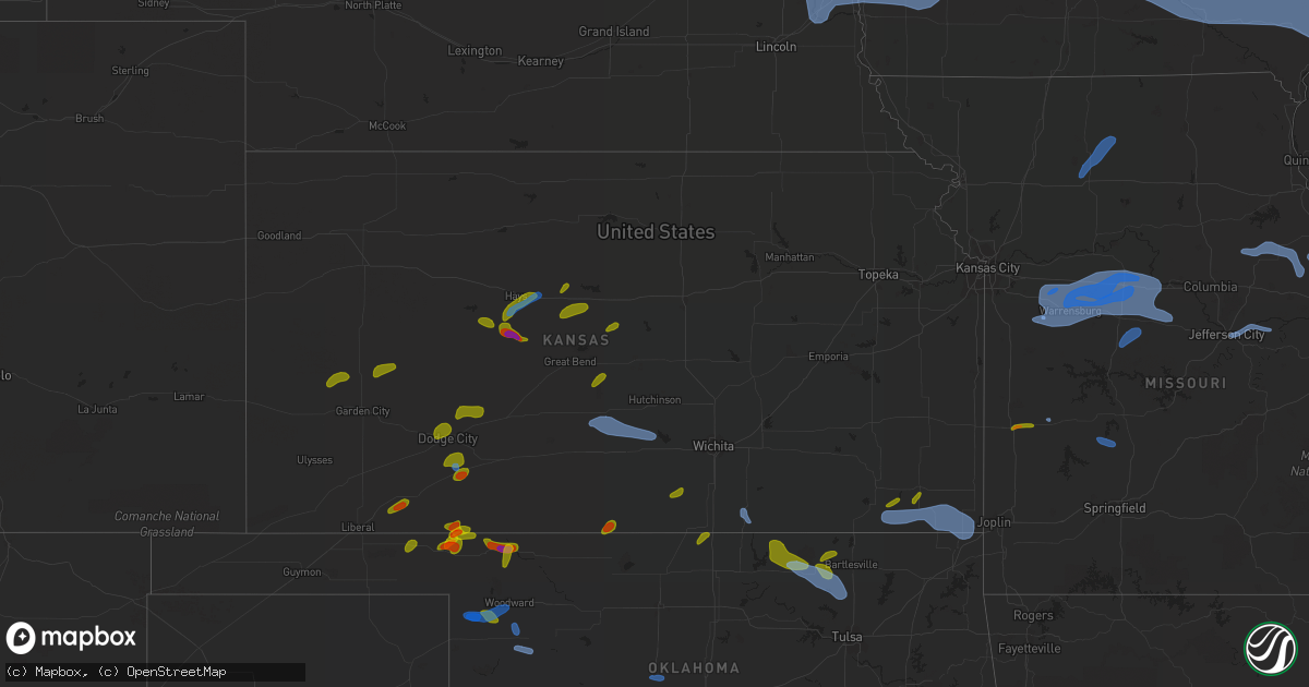
Hail Map in Kansas on August 10, 2020
Get this storm
August 10 map
$229
one time, instant access
Download today. No call, no setup
Keep the $229
Bought the map and want the full workflow? Apply the entire $229 to a subscription within 7 days. None of it is wasted.
Every map, not just this one
This buys you this map. Subscription and you get every map we run, in the markets you choose from a few cities to whole states to nationwide. Plus real-time alerts the moment a storm fires.
Contact data
Name, contact info, occupancy, even credit band for addresses in the footprint. You go from where it hit to who to call.
Become the source they trust
Unlimited branding weather history reports on demand. You already have the documented answer ready for the property owner, and you are the one who showed up with it.
Property data and RoofTrace estimates
Pull up any address you have got, its value and the exact code rules for that jurisdiction, straight from One Click Code. Then RoofTrace estimates the squares, pitch, and roof value, priced the way you price.
Storm reports in Kansas
Kansas
| Date | Description |
|---|---|
| 08/10/20206:50 PM CDT | Mesonet station k5wkr 2 nw victoria. |
| 08/10/20206:07 PM CDT | The wind was estimated at 60 to 70 mph. |
| 08/10/20206:00 PM CDT | Corrects event time from previous tstm wnd dmg report from ford. Several tree branches blown down. Pictures on social media and time was estimated by radar. |
| 08/10/20205:45 PM CDT | Several tree branches blown down. Pictures on social media and time was estimated by radar. |
| 08/10/20205:43 PM CDT | A local report indicates 1.75 inch wind near 5 W LIEBENTHAL |
| 08/10/20205:43 PM CDT | Shingles blown off. |
| 08/10/20205:30 PM CDT | Mesonet station dw9907 bloom. |
| 08/10/20205:23 PM CDT | A local report indicates 1.75 inch wind near 3 NW LA CROSSE |
| 08/10/20205:18 PM CDT | 6 inch diameter tree branches down in arkansas city. |
| 08/10/20205:12 PM CDT | Roof blown off an outbuilding along with several large trees down. |
| 08/10/20205:08 PM CDT | A local report indicates 63 MPH wind near STROTHER FIELD AIRPORT |
| 08/10/20205:05 PM CDT | A local report indicates 2.00 inch wind near LA CROSSE |
| 08/10/20204:55 PM CDT | At least 5 downed tress in rural areas. Time based on radar. |
| 08/10/20204:52 PM CDT | Corrects previous tstm wnd dmg report from 2 wsw hallowell. Cherokee county emergency management director observed 65 to 70 mph winds along highway 160 east of oswego. |
| 08/10/20204:52 PM CDT | Cherokee county emergency management director observed 65 to 70 mph winds along highway 160 east of oswego. |
| 08/10/20204:46 PM CDT | A local report indicates 60 MPH wind near OSWEGO |
| 08/10/20204:41 PM CDT | A local report indicates 60 MPH wind near 1 ENE FRIEND |
| 08/10/20204:35 PM CDT | A local report indicates 1.00 inch wind near 2 N DODGE CITY |
| 08/10/20204:27 PM CDT | A local report indicates 1.25 inch wind near 2 NNW DODGE CITY |
| 08/10/20204:25 PM CDT | A local report indicates 1.25 inch wind near 2 NNW DODGE CITY |
| 08/10/20204:22 PM CDT | A local report indicates 1.00 inch wind near 1 S PARSONS |
| 08/10/20204:19 PM CDT | Dime hail along with 70 mph winds. |
| 08/10/20204:18 PM CDT | Asos station kcfv coffeyville. |
| 08/10/20204:14 PM CDT | A local report indicates 60 MPH wind near COFFEYVILLE |
| 08/10/20204:05 PM CDT | A local report indicates 65 MPH wind near LIBERTY |
| 08/10/20204:04 PM CDT | Asos station kcfv coffeyville. |
| 08/10/20205:55 AM CDT | At 1055 AM MDT/1155 AM CDT/, severe thunderstorms were located along a line extending from 8 miles northwest of Monument to 13 miles southeast of Wallace, and are nearly stationary. HAZARD...60 mph wind gusts and penny size hail. SOURCE...Radar indicated. IMPACT...Expect damage to roofs, siding, and trees. Locations impacted include... Winona, Monument and Russell Springs. This includes Interstate 70 in Kansas between mile markers 68 and 70. |
| 08/10/20204:38 AM CDT | At 937 PM CDT, a severe thunderstorm was located near Conway Springs, moving east at 15 mph. HAZARD...60 mph wind gusts and quarter size hail. SOURCE...Radar indicated. IMPACT...Hail damage to vehicles is expected. Expect wind damage to roofs, siding, and trees. Locations impacted include... Wellington, Mulvane, Belle Plaine, Conway Springs, Oxford, Mayfield, Milan, Riverdale and Wellington Airport.This includes Interstate 35 between Mile Markers 13 and 33. |
| 08/10/20202:28 AM CDT | At 728 PM CDT, a severe thunderstorm was located near Raymond, or 11 miles southeast of Ellinwood, moving northeast at 30 mph. HAZARD...60 mph wind gusts and quarter size hail. SOURCE...Radar indicated. IMPACT...Hail damage to vehicles is expected. Expect wind damage to roofs, siding, and trees. Locations impacted include... Hutchinson, Lyons, South Hutchinson, Sterling, Nickerson, Little River, Chase, Alden, Raymond, Willowbrook and Silica. |
| 08/10/20202:26 AM CDT | At 726 PM CDT, a severe thunderstorm was located 9 miles east of Milberger, or 10 miles southeast of Russell, moving east at 30 mph. HAZARD...60 mph wind gusts and quarter size hail. SOURCE...Radar indicated. IMPACT...Hail damage to vehicles is expected. Expect wind damage to roofs, siding, and trees. Locations impacted include... Milberger, Galatia and Susank. This includes Interstate 70 near Mile Marker 204. |
| 08/10/20202:10 AM CDT | At 710 PM CDT, a severe thunderstorm was located near Hudson, moving northeast at 15 mph. HAZARD...60 mph wind gusts and quarter size hail. SOURCE...Radar indicated. IMPACT...Hail damage to vehicles is expected. Expect wind damage to roofs, siding, and trees. Locations impacted include... St. John, Stafford, Hudson, Seward, Neola, Zenith and Dillwyn. |
| 08/10/20201:46 AM CDT | At 645 PM CDT, a severe thunderstorm was located over Victoria, moving northeast at 30 mph. HAZARD...60 mph wind gusts and quarter size hail. SOURCE...Radar indicated. IMPACT...Hail damage to vehicles is expected. Expect wind damage to roofs, siding, and trees. Locations impacted include... Russell, Lucas, Gorham, Luray, Dorrance, Bunker Hill, Paradise, Waldo, Wilson State Park, Wilson Lake and Russell Airport.This includes Interstate 70 between Mile Markers 175 and 204. |
| 08/10/20201:34 AM CDT | At 633 PM CDT, a severe thunderstorm was located near Toulon, moving northeast at 20 mph. HAZARD...60 mph wind gusts and quarter size hail. SOURCE...Radar indicated. IMPACT...Hail damage to vehicles is expected. Expect wind damage to roofs, siding, and trees. Locations impacted include... Victoria, Walker, Catherine, Pfeifer, Emmeram and Toulon. |
| 08/10/20201:33 AM CDT | At 633 PM CDT, a severe thunderstorm was located near Toulon, moving northeast at 20 mph. HAZARD...60 mph wind gusts and quarter size hail. SOURCE...Radar indicated. IMPACT...Hail damage to vehicles is expected. Expect wind damage to roofs, siding, and trees. Locations impacted include... Victoria, Walker, Catherine, Pfeifer, Emmeram and Toulon. |
| 08/10/20201:08 AM CDT | At 608 PM CDT, a severe thunderstorm was located near Meade, moving east at 20 mph. HAZARD...60 mph wind gusts and half dollar size hail. SOURCE...Radar indicated. IMPACT...Hail damage to vehicles is expected. Expect wind damage to roofs, siding, and trees. Locations impacted include... Meade and Meade State Park. |
| 08/10/20201:06 AM CDT | At 606 PM CDT, a severe thunderstorm was located 7 miles north of McCracken, moving north at 20 mph. HAZARD...Golf ball size hail and 70 mph wind gusts. SOURCE...Radar indicated. IMPACT...People and animals outdoors will be injured. Expect hail damage to roofs, siding, windows, and vehicles. Expect considerable tree damage. Wind damage is also likely to mobile homes, roofs, and outbuildings. Locations impacted include... Hays, Ellis, Schoenchen, Liebenthal, Yocemento, Toulon, Munjor, Antonino and Riga. |
| 08/10/202012:56 AM CDT | At 556 PM CDT, a severe thunderstorm was located near Spearville, moving northeast at 5 mph. A second severe storm was located near Ford moving east at 5 mph. HAZARD...60 mph wind gusts and quarter size hail. SOURCE...Radar indicated. IMPACT...Hail damage to vehicles is expected. Expect wind damage to roofs, siding, and trees. Locations impacted include... Bucklin, Spearville, Ford, Wright, Windhorst and Bellefont. |
| 08/10/202012:37 AM CDT | At 537 PM CDT, a severe thunderstorm was located near Hargrave, moving north at 10 mph. HAZARD...Golf ball size hail and 60 mph wind gusts. SOURCE...Radar indicated. IMPACT...People and animals outdoors will be injured. Expect hail damage to roofs, siding, windows, and vehicles. Expect wind damage to roofs, siding, and trees. Locations impacted include... McCracken, Liebenthal and Hargrave. |
| 08/10/202012:28 AM CDT | At 527 PM CDT, a severe thunderstorm was located 8 miles south of Mullinville, moving northeast at 5 mph. HAZARD...60 mph wind gusts and half dollar size hail. SOURCE...Radar indicated. IMPACT...Hail damage to vehicles is expected. Expect wind damage to roofs, siding, and trees. This severe thunderstorm will remain over mainly rural areas of southwestern Kiowa County. |
| 08/10/202012:25 AM CDT | At 525 PM CDT, a severe thunderstorm was located near Hargrave, moving northeast at 5 mph. HAZARD...Golf ball size hail and 60 mph wind gusts. SOURCE...Radar indicated. IMPACT...People and animals outdoors will be injured. Expect hail damage to roofs, siding, windows, and vehicles. Expect wind damage to roofs, siding, and trees. Locations impacted include... Liebenthal. |
| 08/10/202012:23 AM CDT | At 523 PM CDT, a severe thunderstorm was located near Bloom, moving northeast at 5 mph. HAZARD...60 mph wind gusts and quarter size hail. SOURCE...Radar indicated. IMPACT...Hail damage to vehicles is expected. Expect wind damage to roofs, siding, and trees. Locations impacted include... Bloom and Kingsdown. |
| 08/10/202012:20 AM CDT | At 520 PM CDT, a severe thunderstorm was located 4 miles north of Selman, moving east at 5 mph. HAZARD...60 mph wind gusts and quarter size hail. SOURCE...Radar indicated. IMPACT...Hail damage to vehicles is expected. Expect wind damage to roofs, siding, and trees. Locations impacted include... Selman. |
| 08/10/202012:15 AM CDT | At 515 PM CDT, a severe thunderstorm was located near Amorita, and is nearly stationary. HAZARD...60 mph wind gusts and quarter size hail. SOURCE...Radar indicated. IMPACT...Hail damage to vehicles is expected. Expect wind damage to roofs, siding, and trees. Locations impacted include... Amorita, Byron and Waldron. |
| 08/10/202012:12 AM CDT | At 511 PM CDT, a severe thunderstorm was located over Arkansas City, moving southeast at 25 mph. HAZARD...60 mph wind gusts and penny size hail. SOURCE...Radar indicated. IMPACT...Expect damage to roofs, siding, and trees. Locations impacted include... Arkansas City, Winfield, Dexter, Geuda Springs, Maple City and Strother Field Airport. |
| 08/10/202012:01 AM CDT | At 501 PM CDT, a severe thunderstorm was located very near Bison, moving north at 20 mph. HAZARD...60 mph wind gusts and quarter size hail. SOURCE...Radar indicated. IMPACT...Hail damage to vehicles is expected. Expect wind damage to roofs, siding, and trees. Locations impacted include... La Crosse, Bison, Timken, Loretta and Pfeifer. |
| 08/10/202012:00 AM CDT | At 500 PM CDT, a severe thunderstorm was located 5 miles northeast of Buffalo, and is nearly stationary. HAZARD...60 mph wind gusts and quarter size hail. SOURCE...Radar indicated. IMPACT...Hail damage to vehicles is expected. Expect wind damage to roofs, siding, and trees. This severe thunderstorm will remain over mainly rural areas of northeastern Harper County. |
| 08/09/202011:51 PM CDT | At 451 PM CDT, a severe thunderstorm was located 13 miles east of Friend, moving northeast at 15 mph. HAZARD...60 mph wind gusts and penny size hail. SOURCE...Trained weather spotters reported 55 mph winds and blowing dust on US 83 at the Scott and Finney County line at 444 PM . IMPACT...Expect damage to roofs, siding, and trees. Locations impacted include... Amy. |
| 08/09/202011:41 PM CDT | At 441 PM CDT, a severe thunderstorm was located over Oswego, moving east at 35 mph. HAZARD...60 mph wind gusts and penny size hail. SOURCE...Trained weather spotters. IMPACT...Expect damage to roofs, siding, and trees. Locations impacted include... Parsons, Oswego, Chetopa, Altamont, Edna, Mound Valley, Bartlett and Labette. |
| 08/09/202011:29 PM CDT | At 429 PM CDT, a severe thunderstorm was located near Hazelton, moving northeast at 15 mph. HAZARD...Quarter size hail. SOURCE...Radar indicated. IMPACT...Damage to vehicles is expected. Locations impacted include... Hazelton. |
| 08/09/202011:28 PM CDT | At 427 PM CDT, a severe thunderstorm was located near Dodge City, moving northeast at 15 mph. Quarter sized hail was reported in Dodge City at 4:26 PM. HAZARD...Quarter size hail. SOURCE...Trained weather spotters. IMPACT...Damage to vehicles is expected. Locations impacted include... Dodge City, Spearville and Wright. |
| 08/09/202011:26 PM CDT | At 426 PM CDT, severe thunderstorms were located along a line extending from near Parsons to near Altamont to near Edna, moving east at 40 mph. HAZARD...60 mph wind gusts and quarter size hail. SOURCE...Radar indicated. IMPACT...Hail damage to vehicles is expected. Expect wind damage to roofs, siding, and trees. Locations impacted include... Baxter Springs... Columbus... Galena... Cherokee... Weir... Lowell... Sherman... Scammon... West Mineral... Treece... Roseland... Neutral... Melrose... Riverton... Lawton... Carona... Skidmore... Hallowell... Sherwin... Faulkner... |
| 08/09/202011:26 PM CDT | At 426 PM CDT, a severe thunderstorm was located over Hazelton, moving northeast at 15 mph. HAZARD...Ping pong ball size hail and 60 mph wind gusts. SOURCE...Radar indicated. IMPACT...People and animals outdoors will be injured. Expect hail damage to roofs, siding, windows, and vehicles. Expect wind damage to roofs, siding, and trees. Locations impacted include... Anthony, Harper, Attica, Danville, Waldron, Corwin and Crystal Springs. |
| 08/09/202011:20 PM CDT | At 419 PM CDT, a severe thunderstorm was located 8 miles southeast of Englewood, moving east at 10 mph. Another intensifying thunderstorm was located just to north of Buffalo HAZARD...60 mph wind gusts and quarter size hail. SOURCE...Radar indicated. IMPACT...Hail damage to vehicles is expected. Expect wind damage to roofs, siding, and trees. Locations impacted include... Buffalo. |
| 08/09/202011:08 PM CDT | At 408 PM CDT, severe thunderstorms were located along a line extending from near Altamont to near Dearing, moving east at 30 mph. HAZARD...70 mph wind gusts and quarter size hail. SOURCE...Radar indicated. IMPACT...Hail damage to vehicles is expected. Expect considerable tree damage. Wind damage is also likely to mobile homes, roofs, and outbuildings. Locations impacted include... Chetopa, Edna, Bartlett and Angola. |
| 08/09/202011:02 PM CDT | At 402 PM CDT, a severe thunderstorm was located near Englewood, moving northeast at 15 mph. HAZARD...60 mph wind gusts and quarter size hail. SOURCE...Radar indicated. IMPACT...Hail damage to vehicles is expected. Expect wind damage to roofs, siding, and trees. Locations impacted include... Ashland, Englewood, Sitka and Acres. |
| 08/09/202011:01 PM CDT | At 400 AM CDT, a severe thunderstorm was located 8 miles southwest of Arlington, or 13 miles northwest of Kingman, moving east at 30 mph. HAZARD...60 mph wind gusts. SOURCE...Radar indicated. IMPACT...Expect damage to roofs, siding, and trees. Locations impacted include... Kingman, Haven, Pretty Prairie, Arlington, Cunningham, Turon, Partridge, Yoder, Murdock, Waterloo, Langdon, Penalosa, Mt Vernon, Kingman Airport, Cheney State Park and Cheney Lake. |
| 08/09/202010:49 PM CDT | At 349 PM CDT, a severe thunderstorm was located 6 miles east of Cherryvale, moving east at 15 mph. HAZARD...60 mph wind gusts and half dollar size hail. SOURCE...Radar indicated. IMPACT...Hail damage to vehicles is expected. Expect wind damage to roofs, siding, and trees. Locations impacted include... Parsons, Oswego, Altamont, Mound Valley, Labette, Parsons Tri City Airport, Dennis and Big Hill Lake. |
| 08/09/202010:41 PM CDT | At 341 PM CDT, a severe thunderstorm was located over Tyro, or near Caney, moving east at 15 mph. HAZARD...60 mph wind gusts and half dollar size hail. SOURCE...Radar indicated. IMPACT...Hail damage to vehicles is expected. Expect wind damage to roofs, siding, and trees. Locations impacted include... Coffeyville, Independence, Cherryvale, Caney, Dearing, Tyro, Liberty, Havana, Bolton, Independence Airport and Coffeyville Airport. |
| 08/09/20207:40 PM CDT | 50 to 60 mph winds. |
All States Impacted by Hail Map on August 10, 2020
Cities Impacted by Hail Map on August 10, 2020
- Marienthal, KS
- Holcomb, KS
- Deerfield, KS
- Buffalo, OK
- Rosston, OK
- Englewood, KS
- Ashland, KS
- Cherryvale, KS
- Altamont, KS
- Parsons, KS
- Hazelton, KS
- Burlington, OK
- Waldron, KS
- Kiowa, KS
- Garden City, KS
- Scott City, KS
- Healy, KS
- Wright, KS
- Dodge City, KS
- Jetmore, KS
- Spearville, KS
- Hanston, KS
- La Crosse, KS
- Bison, KS
- McCracken, KS
- Brownell, KS
- Victoria, KS
- Hays, KS
- Ford, KS
- Minneola, KS
- Plains, KS
- Dorrance, KS
- Bunker Hill, KS
- Russell, KS
- Hudson, KS
- Raymond, KS
- Holyrood, KS
- Lorraine, KS
- Ellsworth, KS
- Conway Springs, KS
- Argonia, KS
- Waseca, MN
- New Richland, MN
- Pemberton, MN
- Mapleton, MN
- Janesville, MN
- Ellendale, MN
- Minnesota Lake, MN
- Waldorf, MN
- Centerview, MO
- Bates City, MO
- Otterville, MO
- Holden, MO
- Sedalia, MO
- Kingsville, MO
- Franklin, MO
- Higginsville, MO
- Warrensburg, MO
- Knob Noster, MO
- Boonville, MO
- Chilhowee, MO
- Concordia, MO
- Houstonia, MO
- Mayview, MO
- Pilot Grove, MO
- Nelson, MO
- Tipton, MO
- Smithton, MO
- Whiteman Air Force Base, MO
- Syracuse, MO
- Clarksburg, MO
- Blackburn, MO
- Odessa, MO
- Hughesville, MO
- Bunceton, MO
- Sweet Springs, MO
- Leeton, MO
- Blackwater, MO
- Marshall, MO
- La Monte, MO
- Mora, MO
- Cole Camp, MO
- Florence, MO
- Rush Hill, MO
- Thompson, MO
- Montgomery City, MO
- Wellsville, MO
- Mexico, MO
- Centralia, MO
- Laddonia, MO
- Vandalia, MO
- Middletown, MO
- Farber, MO
- Galt, MO
- Humphreys, MO
- Chillicothe, MO
- Chula, MO
- Trenton, MO
- Browning, MO
- Laredo, MO
- Jefferson City, MO
- Holts Summit, MO
- Bonnots Mill, MO
- Chamois, MO
- Tebbetts, MO
- Lake Saint Louis, MO
- Moscow Mills, MO
- Red Bud, IL
- Festus, MO
- Eolia, MO
- Prairie Du Rocher, IL
- Lenzburg, IL
- Eureka, MO
- Wildwood, MO
- Baldwin, IL
- Ashley, IL
- Herculaneum, MO
- Saint Libory, IL
- New Baden, IL
- Imperial, MO
- Hillsboro, MO
- Smithton, IL
- Troy, MO
- Ballwin, MO
- Arnold, MO
- Wentzville, MO
- Columbia, IL
- Mascoutah, IL
- East Carondelet, IL
- Old Monroe, MO
- Marissa, IL
- Fults, IL
- O'Fallon, MO
- Waterloo, IL
- Tamaroa, IL
- Belleville, IL
- Chesterfield, MO
- Millstadt, IL
- Winfield, MO
- Richview, IL
- Sparta, IL
- Oakdale, IL
- Okawville, IL
- Elsberry, MO
- High Ridge, MO
- Saint Peters, MO
- Nashville, IL
- Barnhart, MO
- House Springs, MO
- Defiance, MO
- Hecker, IL
- Coulterville, IL
- Addieville, IL
- Pevely, MO
- Hawk Point, MO
- Freeburg, IL
- Valley Park, MO
- Pinckneyville, IL
- Fenton, MO
- New Athens, IL
- Silex, MO
- Crystal City, MO
- Dupo, IL
- Valmeyer, IL
- Saint Charles, MO
- Tilden, IL
- Bowling Green, MO
- Du Bois, IL
- Evansville, IL
- Saint Louis, MO
- El Dorado Springs, MO
- Bolivar, MO
- Flemington, MO
- Polk, MO
- Freeport, IL
- Dakota, IL
- Lena, IL
- Kent, IL
- Stockton, IL
- Rock City, IL
- McConnell, IL
- Pearl City, IL
- Cedarville, IL
- Rockford, IL
- Winnebago, IL
- Rockton, IL
- Ridott, IL
- Davis, IL
- Pecatonica, IL
- Durand, IL
- Davis Junction, IL
- Belvidere, IL
- Cherry Valley, IL
- Monroe Center, IL
- Garden Prairie, IL
- Marengo, IL
- Morris, IL
- Lombard, IL
- Glen Ellyn, IL
- Villa Park, IL
- Oak Brook, IL
- Elmhurst, IL
- Stratford, TX
- Dalhart, TX
- Vega, TX
- Spearman, TX
- Gruver, TX
- Perryton, TX
- Hereford, TX
- Canyon, TX
- Dimmitt, TX
- Happy, TX
- Tulia, TX
- Adrian, TX
- Wildorado, TX
- Sudan, TX
- Borger, TX
- Skellytown, TX
- Panhandle, TX
- Pampa, TX
- Miami, TX
- Lohrville, IA
- Carroll, IA
- Odebolt, IA
- Glidden, IA
- Lanesboro, IA
- Auburn, IA
- Kiron, IA
- Battle Creek, IA
- Lake City, IA
- Breda, IA
- Wall Lake, IA
- Arthur, IA
- Ida Grove, IA
- Churdan, IA
- Vail, IA
- Charter Oak, IA
- Arion, IA
- Manilla, IA
- Manning, IA
- Ute, IA
- Dunlap, IA
- Westside, IA
- Dow City, IA
- Mapleton, IA
- Denison, IA
- Coon Rapids, IA
- Scranton, IA
- Jefferson, IA
- Cascade, IA
- Bernard, IA
- Parnell, IA
- Alexandria, IN
- Griffith, IN
- Zearing, IA
- Le Claire, IA
- New Buffalo, MI
- Reddick, IL
- Stillman Valley, IL
- Huxley, IA
- Maple Park, IL
- Wren, OH
- Kimmell, IN
- Princeville, IL
- Crescent City, IL
- Tampico, IL
- Soldier, IA
- Elmwood Park, IL
- Bristol, IL
- Loda, IL
- Slater, IA
- New Goshen, IN
- Forest City, IL
- Spencerville, IN
- Osceola, IN
- Tolono, IL
- Harlan, IA
- Carman, IL
- Macy, NE
- Yates City, IL
- Alvin, IL
- Newtown, IN
- Hills, IA
- Lawndale, IL
- Groveland, IL
- Grovertown, IN
- Lost Nation, IA
- Kewanna, IN
- Evergreen Park, IL
- Bloomingdale, IN
- Berkeley, IL
- Davenport, IA
- Lake View, IA
- Garwin, IA
- Caledonia, WI
- Irwin, IA
- University Park, IL
- Wayne, IL
- Springville, IA
- Morocco, IN
- Delavan, IL
- Homestead, IA
- Sheridan, IL
- Mooseheart, IL
- Franklin Grove, IL
- Creve Coeur, IL
- Mark Center, OH
- Batavia, IL
- Edgerton, OH
- Galien, MI
- Woodhull, IL
- Urbandale, IA
- Windfall, IN
- Round Lake, IL
- Emington, IL
- Saunemin, IL
- Pine Village, IN
- Magnolia, IA
- Russiaville, IN
- Worth, IL
- Aspinwall, IA
- Reinbeck, IA
- Grundy Center, IA
- Marne, IA
- Alamo, IN
- Cedar, IA
- Bartlett, IL
- Wapella, IL
- Chebanse, IL
- Hebron, IL
- Olds, IA
- Danville, IA
- Papineau, IL
- Stevensville, MI
- Ely, IA
- Independence, IA
- Stuart, IA
- Kenosha, WI
- Park Ridge, IL
- Spring Valley, IL
- Little York, IL
- Whitestown, IN
- Kalamazoo, MI
- Caledonia, IL
- Pleasant Prairie, WI
- Brookston, IN
- Grinnell, IA
- Williamsville, IL
- London Mills, IL
- Yeoman, IN
- Stone Park, IL
- Boswell, IN
- Walkerton, IN
- Lemont, IL
- Hudson, IA
- Cuba, IL
- Grand Ridge, IL
- Westpoint, IN
- Seneca, IL
- Thornton, IL
- Payne, OH
- Maywood, IL
- Fair Oaks, IN
- Great Lakes, IL
- Roberts, IL
- Veedersburg, IN
- Oswego, IL
- Crystal Lake, IL
- Staunton, IN
- Decatur, MI
- Grover Hill, OH
- Laura, IL
- Westchester, IL
- Jones, MI
- Clinton, WI
- Willshire, OH
- Marshalltown, IA
- Gladbrook, IA
- New Bremen, OH
- Kinsman, IL
- Emerson, IA
- Eldon, IA
- Palatine, IL
- Hanna City, IL
- New Windsor, IL
- Coloma, MI
- Gridley, IL
- Keswick, IA
- Manteno, IL
- Walnut, IL
- Marshall, IN
- Cambridge, IA
- Conroy, IA
- Spragueville, IA
- Kelley, IA
- Grand Junction, MI
- Muncie, IN
- Waterloo, NE
- Paxton, IL
- Mansfield, IL
- Lafayette, IN
- Manchester, IA
- Greencastle, IN
- Moscow, IA
- Crawfordsville, IA
- Morton Grove, IL
- Somonauk, IL
- Sherwood, OH
- Kalida, OH
- Clarence, IA
- Stanwood, IA
- North Sioux City, SD
- Monroe, IN
- Sheffield, IL
- Fowler, IN
- Constantine, MI
- Wilmette, IL
- Royal, IL
- Ferguson, IA
- Roachdale, IN
- Easton, IL
- Saint Joe, IN
- Taylor Ridge, IL
- Clemons, IA
- Riverside, IA
- River Grove, IL
- Coggon, IA
- Arlington Heights, IL
- Boone, IA
- Kirkville, IA
- Botkins, OH
- Emden, IL
- Shipshewana, IN
- Oakwood, IL
- Wanatah, IN
- Oneida, IL
- Yorkville, IL
- Solon, IA
- Cicero, IL
- Lexington, IL
- La Motte, IA
- Momence, IL
- Paragon, IN
- Craig, NE
- Monroe, IA
- Baroda, MI
- Mount Carroll, IL
- Altona, IL
- Buffalo Grove, IL
- Cary, IL
- Yutan, NE
- Bellevue, IA
- Gilson, IL
- Delta, IA
- Lima, OH
- Bourbon, IN
- Defiance, OH
- Verona, IL
- Panora, IA
- Minonk, IL
- Johnston, IA
- Eureka, IL
- Keota, IA
- Griswold, IA
- Rio, IL
- Cedar Rapids, IA
- Genoa, IL
- Capron, IL
- Lockridge, IA
- Arthur, IL
- Thomasboro, IL
- Osco, IL
- Serena, IL
- Hornick, IA
- Keithsburg, IL
- Colfax, IA
- Wilton, IA
- Fairfield, IA
- Harper, IA
- Council Bluffs, IA
- Lidderdale, IA
- Springfield, NE
- Fox Lake, IL
- Rippey, IA
- Dixon, IA
- New Haven, IN
- La Salle, IL
- Bouton, IA
- Chicago Heights, IL
- Arcola, IL
- Kokomo, IN
- Shelby, IN
- East Moline, IL
- Oxford, IA
- Wapello, IA
- Hometown, IL
- Waynetown, IN
- Bainbridge, IN
- Markle, IN
- Avilla, IN
- Genoa City, WI
- Pesotum, IL
- Elliott, IL
- Le Roy, IL
- Hayesville, IA
- Milford, IL
- Plano, IL
- Olin, IA
- Toulon, IL
- Homewood, IL
- Willowbrook, IL
- Mitchellville, IA
- Climax, MI
- Algonquin, IL
- Smithland, IA
- Buffalo, IL
- Durant, IA
- Danvers, IL
- Wakarusa, IN
- Bloomingdale, IL
- West Brooklyn, IL
- Tipton, IN
- Lovilia, IA
- Coatesville, IN
- Oakford, IL
- Andover, IL
- Maroa, IL
- Ludlow, IL
- McClelland, IA
- Toddville, IA
- Mount Auburn, IA
- Hooper, NE
- Piper City, IL
- Chesterton, IN
- Addison, IL
- La Place, IL
- Georgetown, IL
- Yale, IA
- Perrysville, IN
- New Bedford, IL
- Lane, IL
- Minooka, IL
- Preston, IA
- Arrowsmith, IL
- Columbus Junction, IA
- Pekin, IL
- Lawton, MI
- Barrington, IL
- Ladoga, IN
- Wataga, IL
- South Wilmington, IL
- New Ross, IN
- Mount Pleasant, IA
- North Aurora, IL
- Bremen, IN
- Dalzell, IL
- Larwill, IN
- East Galesburg, IL
- Blakesburg, IA
- New Troy, MI
- Van Wert, OH
- Newton, IA
- Goshen, IN
- Wellington, IL
- Hickory Hills, IL
- Canton, IL
- Mount Pulaski, IL
- Monmouth, IL
- Saint Joseph, MI
- Pleasant Valley, IA
- Bettendorf, IA
- Lacona, IA
- Whitten, IA
- Park Forest, IL
- Winthrop Harbor, IL
- Hoopeston, IL
- North English, IA
- Lovington, IL
- Springfield, IL
- Randall, IA
- Russellville, IN
- Spencerville, OH
- Monterey, IN
- Lowden, IA
- Rensselaer, IN
- Kellogg, IA
- Metcalf, IL
- White Heath, IL
- Newhall, IA
- Loves Park, IL
- Lincolnwood, IL
- Des Plaines, IL
- Milmine, IL
- Fairview, IL
- Hillside, IL
- Allegan, MI
- Rossville, IL
- Oak Lawn, IL
- Hindsboro, IL
- Carlock, IL
- Melrose Park, IL
- Saint Anne, IL
- Elliott, IA
- Mahomet, IL
- North Liberty, IA
- Erie, IL
- Ira, IA
- Avoca, IA
- Kilbourne, IL
- Underwood, IA
- Waynesville, IL
- Bensenville, IL
- Marion, IA
- Dana, IN
- Cutler, IN
- Brazil, IN
- Washington, IA
- Brook, IN
- Linden, IA
- Beverly Shores, IN
- West Chester, IA
- Summit Argo, IL
- Indianola, IA
- Clinton, IN
- Pella, IA
- Bancroft, NE
- Guernsey, IA
- Ackworth, IA
- Westfield, IN
- Wilmot, WI
- Winfield, IA
- Emerson, NE
- Blue Island, IL
- Robbins, IL
- Gifford, IL
- Dubuque, IA
- Camargo, IL
- Naperville, IL
- Kingsford Heights, IN
- Hubbard, NE
- Franklin Park, IL
- Cloverdale, IN
- Sodus, MI
- Waveland, IN
- Elkhart, IN
- Bloomington, IL
- Sac City, IA
- Churubusco, IN
- Wilmington, IL
- Rochelle, IL
- Magnolia, IL
- Milo, IA
- Winfield, IL
- Glasford, IL
- Dundee, IL
- Martinsburg, IA
- Tallula, IL
- Little Sioux, IA
- Donahue, IA
- Farnhamville, IA
- Hartsburg, IL
- Dixon, IL
- Lowpoint, IL
- Big Rock, IL
- Dekalb, IL
- Venedocia, OH
- Tekamah, NE
- Zionsville, IN
- Story City, IA
- Craigville, IN
- Letts, IA
- Winnebago, NE
- Central City, IA
- Cabery, IL
- Oquawka, IL
- West Chicago, IL
- West Des Moines, IA
- Cushing, IA
- Bennett, IA
- Wheatfield, IN
- Battle Creek, MI
- Putnamville, IN
- Palos Heights, IL
- Brandon, IA
- Chicago, IL
- Bagley, IA
- Louisville, NE
- Deep River, IA
- Bondville, IL
- Clarks Hill, IN
- Exira, IA
- Glenview, IL
- Joy, IL
- Scott, OH
- Danbury, IA
- Posen, IL
- Norwalk, IA
- Bismarck, IL
- Treynor, IA
- Bringhurst, IN
- Berrien Center, MI
- De Witt, IA
- Danville, IN
- Polk City, IA
- Sully, IA
- Lone Tree, IA
- Newman, IL
- Dover, IL
- Raymond, IA
- Olympia Fields, IL
- Evansdale, IA
- Brooklyn, IN
- Gilman, IL
- Gibson City, IL
- Fishers, IN
- Mossville, IL
- Persia, IA
- Clutier, IA
- Chillicothe, IA
- Rolling Prairie, IN
- Dallas Center, IA
- Oakwood, OH
- Lincolnshire, IL
- Waterford, WI
- Urbana, IA
- Chenoa, IL
- Sibley, IL
- Center Junction, IA
- Traer, IA
- Dedham, IA
- Garrett, IN
- Hickory Corners, MI
- Bridgman, MI
- Bonfield, IL
- Fremont, IA
- Trafalgar, IN
- Colfax, IN
- Eldridge, IA
- McCallsburg, IA
- La Rose, IL
- Knox, IN
- Elk Horn, IA
- Grayslake, IL
- Sadorus, IL
- Rhodes, IA
- Lynnville, IA
- Paw Paw, MI
- Minburn, IA
- Lakeville, IN
- Hamilton, IA
- Brimfield, IL
- Oakland, IL
- Oglesby, IL
- Kingston, IL
- Dana, IL
- Burlington, IA
- Searsboro, IA
- Mineral, IL
- Wheatland, IA
- Seaton, IL
- Clifton, IL
- Gosport, IN
- Huntley, IL
- Havana, IL
- Ligonier, IN
- Conrad, IA
- Young America, IN
- Henderson, IA
- Congerville, IL
- Onslow, IA
- Hedrick, IA
- Midlothian, IL
- Wood Dale, IL
- Crestwood, IL
- Spring Grove, IL
- Glenwood, IL
- Steger, IL
- Wenona, IL
- Trevor, WI
- Lawrence, MI
- Braceville, IL
- Philo, IL
- Hanover, IL
- Mount Morris, IL
- Riverside, IL
- Columbia City, IN
- Illinois City, IL
- Hennepin, IL
- Lapel, IN
- Universal, IN
- Dewey, IL
- Greentown, IN
- Hooppole, IL
- Winamac, IN
- Broadview, IL
- Adel, IA
- Saint Charles, IL
- Daleville, IN
- Worthington, IA
- Lebanon, IN
- Hinckley, IL
- Tuscola, IL
- Hazel Crest, IL
- Watseka, IL
- Carson, IA
- Smithshire, IL
- Oakland, IA
- Cisco, IL
- Climbing Hill, IA
- Princeton, IA
- Cassopolis, MI
- Middletown, IL
- Princeton, IL
- Sioux City, IA
- Michigan City, IN
- Red Oak, IA
- Catlin, IL
- Watkins, IA
- Brighton, IA
- Tracy, IA
- Williamsport, IN
- Schneider, IN
- Saint John, IN
- Speer, IL
- Bristol, IN
- Sloan, IA
- Rockford, OH
- Bondurant, IA
- Hamlet, IN
- Cissna Park, IL
- Prole, IA
- Silver Lake, WI
- Cantrall, IL
- Decatur, NE
- Gobles, MI
- Adair, IA
- Rose Hill, IA
- Middletown, IA
- Middlebury, IN
- Logan, IA
- Atlantic, IA
- Fithian, IL
- Northbrook, IL
- Hopkinton, IA
- Roselle, IL
- Pleasantville, IA
- Pilot Mound, IA
- Forest Park, IL
- Hobart, IN
- Welton, IA
- Reelsville, IN
- Pender, NE
- Armstrong, IL
- Hancock, IA
- Glencoe, IL
- Claypool, IN
- Plainfield, IN
- Tama, IA
- Richton Park, IL
- Fisher, IL
- Crown Point, IN
- Dewitt, IL
- Elmwood, IL
- De Land, IL
- Francesville, IN
- Reasnor, IA
- Highland, IN
- Crawfordsville, IN
- Normal, IL
- Macy, IN
- Panama, IA
- Buck Creek, IN
- Glenwood, IA
- Oakland, NE
- Somers, IA
- Defiance, IA
- Elizabeth, IL
- Vandalia, MI
- Buda, IL
- Farmington, IL
- Muscatine, IA
- Joliet, IL
- Wyanet, IL
- Long Grove, IA
- Portsmouth, IA
- Albion, IA
- Villa Grove, IL
- Callender, IA
- Epworth, IA
- Anderson, IN
- Orland Park, IL
- Warrensburg, IL
- Benson, IL
- Campus, IL
- Montezuma, IA
- Anchor, IL
- South Bend, IN
- Mulberry, IN
- Lewis, IA
- Sawyer, MI
- Esmond, IL
- Bowling Green, IN
- Riverton, IL
- Millington, IL
- Harcourt, IA
- Wakefield, NE
- Millersburg, IN
- Streator, IL
- Carbon Cliff, IL
- Hinton, IA
- Pittsboro, IN
- Silver Lake, IN
- Garden City, IA
- Cedar Falls, IA
- Wauconda, IL
- Luzerne, IA
- Atkinson, IL
- Kewanee, IL
- Laketon, IN
- Port Byron, IL
- Terre Haute, IN
- Island Lake, IL
- Dakota City, NE
- Shellsburg, IA
- South Bend, NE
- Ellisville, IL
- Templeton, IN
- Schleswig, IA
- Nappanee, IN
- Oregon, IL
- Huntertown, IN
- Cumming, IA
- Riley, IN
- Thurston, NE
- Donovan, IL
- Waukegan, IL
- Advance, IN
- Runnells, IA
- Radcliffe, IA
- Fox River Grove, IL
- Andrew, IA
- Jesup, IA
- Galveston, IN
- Waukee, IA
- Mason City, IL
- Seatonville, IL
- Sparland, IL
- Kempton, IN
- Danville, IL
- Teeds Grove, IA
- Westmont, IL
- Scotts, MI
- Bryan, OH
- Tiffin, IA
- Mokena, IL
- Eldora, IA
- Riverdale, IL
- Wayland, IA
- Portage, IN
- Bryant, IL
- Elburn, IL
- Baileyville, IL
- Richland, IA
- Berwyn, IL
- Correctionville, IA
- Ralston, IA
- Grant Park, IL
- Moline, IL
- Continental, OH
- East Peoria, IL
- Peoria, IL
- Booneville, IA
- Thorntown, IN
- Liberty Mills, IN
- Westville, IN
- Bayard, IA
- Walthill, NE
- Penfield, IL
- Ogden, IL
- Andalusia, IL
- Rantoul, IL
- Rochester, IN
- South Elgin, IL
- Hopedale, IL
- Kendallville, IN
- Avon, IL
- Victoria, IL
- Mount Ayr, IN
- Haverhill, IA
- Frankton, IN
- Papillion, NE
- Peoria Heights, IL
- Silvis, IL
- Wheaton, IL
- Gaston, IN
- Herman, NE
- Troy Grove, IL
- Varna, IL
- Eau Claire, MI
- Heyworth, IL
- Union Grove, WI
- Edelstein, IL
- Battle Ground, IN
- Coal Valley, IL
- Kingsley, IA
- Wadsworth, IL
- Pleasant Hill, IA
- Grimes, IA
- Noblesville, IN
- Saint Anthony, IA
- Woodridge, IL
- Butler, IN
- Cropsey, IL
- Atlanta, IL
- Bourbonnais, IL
- Columbus, IN
- New Holland, IL
- Brookfield, IL
- Gretna, NE
- Elkhart, IA
- Oskaloosa, IA
- West Point, NE
- Cory, IN
- Lake In The Hills, IL
- Savoy, IL
- Union, IL
- New Knoxville, OH
- Cornell, IL
- La Fayette, IL
- Rutland, IL
- Delavan, WI
- Shorewood, IL
- Elkhorn, WI
- Earlham, IA
- Romney, IN
- Albia, IA
- Athens, IL
- Richland, MI
- West Lafayette, IN
- Lake Station, IN
- Union, MI
- Ryan, IA
- Holcomb, IL
- Ambia, IN
- Homer Glen, IL
- Leonore, IL
- Decatur, IL
- Washburn, IL
- Ohio City, OH
- Rowley, IA
- Schererville, IN
- Leaf River, IL
- Lake Villa, IL
- Norris, IL
- Swayzee, IN
- Bridgeton, IN
- Hillsdale, IN
- Flora, IN
- Morning Sun, IA
- Baldwin, IA
- Peru, IL
- Saybrook, IL
- Maquon, IL
- Rossville, IN
- Muncie, IL
- Delmar, IA
- Melrose, OH
- Highwood, IL
- Martinton, IL
- Cedar Point, IL
- West Liberty, IA
- Boxholm, IA
- Anamosa, IA
- Ricketts, IA
- Union Mills, IN
- Summitville, IN
- Flossmoor, IL
- Webster, IA
- Compton, IL
- Etna Green, IN
- Buffalo, IA
- Rockville, IN
- Fairmount, IL
- Lisle, IL
- Ames, IA
- Golf, IL
- Blairstown, IA
- Jamaica, IA
- Rockwell City, IA
- Avon, IN
- Yoder, IN
- Blencoe, IA
- Carbon, IN
- Montezuma, IN
- Buckingham, IL
- Rankin, IL
- Leo, IN
- Niantic, IL
- Woodward, IA
- Bellevue, NE
- Leighton, IA
- Ringwood, IL
- Albion, IN
- Kouts, IN
- Chillicothe, IL
- Morrison, IL
- Libertyville, IA
- Amboy, IL
- Abingdon, IL
- Carlisle, IA
- La Grange, IL
- Dawson, IA
- Buckley, IL
- Kenilworth, IL
- Polo, IL
- Columbus City, IA
- Anthon, IA
- Otsego, MI
- Hoffman Estates, IL
- New Lenox, IL
- Oak Park, IL
- Country Club Hills, IL
- Cecil, OH
- Sperry, IA
- Manlius, IL
- Jamestown, IN
- Dyersville, IA
- Edwards, IL
- Gilbert, IA
- Lanark, IL
- South Beloit, IL
- University Park, IA
- Burket, IN
- Prospect Heights, IL
- Ney, OH
- Forsyth, IL
- Audubon, IA
- Buckland, OH
- Oxford Junction, IA
- North Chicago, IL
- Trivoli, IL
- Fulton, MI
- Rosalie, NE
- Darien, IL
- Hume, IL
- Conesville, IA
- Cortland, IL
- Berwick, IL
- Akron, IN
- Haviland, OH
- Mundelein, IL
- Poplar Grove, IL
- Collins, IA
- Lake Bluff, IL
- Dike, IA
- Hanna, IN
- Harvard, IL
- Whiting, IA
- Wheeling, IL
- Langworthy, IA
- Sherrard, IL
- Hamilton, IN
- Weldon, IL
- Chestnut, IL
- Valley, NE
- Alleman, IA
- East Chicago, IN
- Buchanan, MI
- Colfax, IL
- Knightsville, IN
- Millbrook, IL
- Clive, IA
- Otterbein, IN
- Carmel, IN
- Goodfield, IL
- Brayton, IA
- Neponset, IL
- South Holland, IL
- Grabill, IN
- Topeka, IN
- Elwood, IN
- Monon, IN
- Dowagiac, MI
- Waterloo, IA
- Ladd, IL
- Ossian, IN
- Hammond, IN
- Moorhead, IA
- Wellman, IA
- Dolton, IL
- Media, IL
- Missouri Valley, IA
- North Liberty, IN
- Kempton, IL
- Melbourne, IA
- Charlotte, IA
- White Pigeon, MI
- Ophiem, IL
- South English, IA
- Atlanta, IN
- Offutt Afb, NE
- Waterman, IL
- Swan, IA
- Onarga, IL
- Chelsea, IA
- Deer Grove, IL
- Linden, IN
- Maxwell, IA
- Lake Zurich, IL
- Monee, IL
- Henry, IL
- Itasca, IL
- Mentone, IN
- Hillsboro, IN
- Corunna, IN
- New Paris, IN
- Columbia, IA
- Casey, IA
- Shirley, IL
- Hampshire, IL
- Wonder Lake, IL
- Ashley, IN
- Stanhope, IA
- Union Hill, IL
- Paris, IL
- La Porte, IN
- Greenview, IL
- State Line, IN
- Beech Grove, IN
- Bennington, NE
- Saint Augustine, IL
- Kirkman, IA
- Pierceton, IN
- Roanoke, IL
- Zanesville, IN
- Henderson, IL
- Brocton, IL
- Milan, IL
- Guthrie Center, IA
- Wawaka, IN
- Fulton, IL
- New Richmond, IN
- Galva, IL
- Ollie, IA
- Paton, IA
- Crest Hill, IL
- Harwood Heights, IL
- Minster, OH
- Bargersville, IN
- Clare, IL
- North Manchester, IN
- La Crosse, IN
- Quasqueton, IA
- Decatur, IN
- Montour, IA
- Kirkland, IL
- Aledo, IL
- Union, IA
- Plainfield, IL
- Schaumburg, IL
- Winona Lake, IN
- Downers Grove, IL
- Marseilles, IL
- Ellsworth, IL
- Lyons, IL
- Minier, IL
- McCausland, IA
- Bridgeview, IL
- Carpentersville, IL
- Morrison, IA
- Roanoke, IN
- Packwood, IA
- Killduff, IA
- Cameron, IL
- Matherville, IL
- Calamus, IA
- Luther, IA
- Morley, IA
- Huntington, IN
- Rosedale, IN
- Convoy, OH
- Bloomingdale, MI
- Springfield, WI
- Illiopolis, IL
- Pleasant Plains, IL
- Batavia, IA
- Greenwood, IN
- Arcola, IN
- Whiting, IN
- Putnam, IL
- Fort Jennings, OH
- Gardner, IL
- Atwood, IL
- Dunlap, IL
- Hubbard, IA
- Niles, IL
- Zion, IL
- Saint Marys, OH
- Rolling Meadows, IL
- Coralville, IA
- Dana, IA
- Brownsburg, IN
- Henning, IL
- Peotone, IL
- Odell, IL
- Franklin, IN
- Wedron, IL
- West Newton, IN
- Ladora, IA
- Zwingle, IA
- Crescent, IA
- Spencer, IN
- Elwood, IL
- North Henderson, IL
- Vining, IA
- Metamora, IL
- Prairie City, IA
- Oakville, IA
- Castana, IA
- Mattawan, MI
- Broadlands, IL
- Mount Union, IA
- Harlan, IN
- Fort Wayne, IN
- Paw Paw, IL
- Martinsville, IN
- Lincoln, IA
- Sabula, IA
- Bradford, IL
- Lockport, IL
- Ellsworth, IA
- Roland, IA
- Bunker Hill, IN
- Toledo, IA
- Dawson, IL
- Monmouth, IA
- Malden, IL
- Royal Center, IN
- Granger, IN
- Fort Calhoun, NE
- Plainwell, MI
- Covert, MI
- Victor, IA
- Cooksville, IL
- Lostant, IL
- Homer, NE
- Indianapolis, IN
- Stronghurst, IL
- Munster, IN
- Moorland, IA
- Harbert, MI
- Oxford, IN
- Justice, IL
- Alburnett, IA
- Iowa City, IA
- Boone Grove, IN
- Swisher, IA
- Laurel, IA
- Sterling, IL
- Gladstone, IL
- Amana, IA
- Fontana, WI
- Three Oaks, MI
- Melvin, IL
- Chicago Ridge, IL
- State Center, IA
- Cherry, IL
- Latham, IL
- Towanda, IL
- Champaign, IL
- Beaverville, IL
- Laotto, IN
- Libertyville, IL
- Burnettsville, IN
- Auburn, IN
- Hillsdale, IL
- Stratford, IA
- South Whitley, IN
- Bellflower, IL
- New Market, IN
- Sturtevant, WI
- Belle Plaine, IA
- Shabbona, IL
- Shannon, IL
- Fenton, IL
- Glendale Heights, IL
- Walker, IA
- Markham, IL
- Deloit, IA
- Gilberts, IL
- Lytton, IA
- Wyoming, IL
- Delhi, IA
- Urbana, IL
- Byron, IL
- New Boston, IL
- Yarmouth, IA
- Elgin, IL
- Lacon, IL
- Lake Village, IN
- Granville, IL
- Warsaw, IN
- Buffalo, IN
- Essex, IL
- Tremont, IL
- Graymont, IL
- Middle Amana, IA
- Rodney, IA
- Ankeny, IA
- San Jose, IL
- Halbur, IA
- Lake Geneva, WI
- Colona, IL
- Eldena, IL
- Lake Forest, IL
- Braidwood, IL
- Hammond, IL
- Kenney, IL
- Ingleside, IL
- Walnut, IA
- Alexis, IL
- East Leroy, MI
- Collison, IL
- Walworth, WI
- Highland Park, IL
- Earlville, IA
- Syracuse, IN
- Frankfort, IN
- Gary, IN
- Arcadia, IN
- Calumet City, IL
- Idaville, IN
- Sergeant Bluff, IA
- Liscomb, IA
- Berwick, IA
- Alsip, IL
- Logansport, IN
- Van Orin, IL
- Woodbine, IA
- Walford, IA
- Brooklyn, IA
- Martelle, IA
- Tipton, IA
- Arlington, IL
- Sheridan, IN
- Leesburg, IN
- Monticello, IA
- Kirklin, IN
- South Haven, MI
- Lee, IL
- Kalona, IA
- Danforth, IL
- Petersburg, IL
- Altoona, IA
- Bryant, IA
- Manito, IL
- Clinton, IL
- Hoagland, IN
- Hicksville, OH
- Elkhart, IL
- Mapleton, IL
- Ora, IN
- Sidney, IL
- Vicksburg, MI
- Romeoville, IL
- Roseville, IL
- Lawton, IA
- Walton, IN
- Fruitland, IA
- Remington, IN
- Hines, IL
- Vernon Hills, IL
- Argos, IN
- Sandwich, IL
- Bolingbrook, IL
- Woodstock, IL
- Murdock, IL
- Mackinaw, IL
- Mingo, IA
- Ridge Farm, IL
- Deerfield, IL
- Delphos, OH
- Buckingham, IA
- Mount Vernon, IA
- Holstein, IA
- Westphalia, IA
- Orion, IL
- Kansasville, WI
- Coal City, IL
- Athens, MI
- Milledgeville, IL
- Farmer City, IL
- Viola, IL
- Galesburg, IL
- Jolley, IA
- Ottawa, OH
- Kankakee, IL
- Redmon, IL
- Attica, IN
- Stockton, IA
- Montgomery, IL
- Cedar Lake, IN
- Wyoming, IA
- Deer Creek, IL
- Dayton, IN
- Richmond, IL
- Triumph, IL
- Gray, IA
- Nichols, IA
- Monrovia, IN
- Farley, IA
- Bristol, WI
- Shelby, IA
- Hinsdale, IL
- Paulding, OH
- Waterloo, IN
- Milford, IN
- Warrenville, IL
- Antioch, IL
- Agency, IA
- Valparaiso, IN
- Burlington, IL
- Mendon, OH
- Berrien Springs, MI
- Frankfort, IL
- Gibson, IA
- Vermilion, IL
- Lisbon, IA
- Schoolcraft, MI
- Lincoln, IL
- Cloverdale, OH
- Elkhorn, NE
- Hebron, IN
- South Pekin, IL
- Beaver, IA
- Matteson, IL
- Bellwood, IL
- Delphi, IN
- Woosung, IL
- Aurora, IL
- Portage, MI
- Blue Grass, IA
- Racine, WI
- Covington, IN
- Boys Town, NE
- Stockland, IL
- Van Meter, IA
- Burlington, WI
- Goodland, IN
- Dahinda, IL
- Granger, IA
- Kentland, IN
- Silver City, IA
- Atkins, IA
- Depue, IL
- Hamlin, IA
- New Liberty, IA
- Williams Bay, WI
- Malcom, IA
- Blackstone, IL
- Thayer, IN
- Redfield, IA
- Sugar Grove, IL
- Macedonia, IA
- Tiskilwa, IL
- Tippecanoe, IN
- Camden, IN
- Saint David, IL
- Geneseo, IL
- Melcher Dallas, IA
- Wiota, IA
- Dysart, IA
- Bradley, IL
- Thomson, IL
- West Branch, IA
- Williamsfield, IL
- Sheldon, IL
- Bussey, IA
- Kingston Mines, IL
- Lyndon, IL
- Poland, IN
- West Terre Haute, IN
- Lizton, IN
- Downs, IL
- Potomac, IL
- Bement, IL
- Lynn Center, IL
- Cicero, IN
- Nineveh, IN
- Beacon, IA
- North Judson, IN
- Allerton, IL
- Pendleton, IN
- Nevada, IA
- Miles, IA
- Chadwick, IL
- Uniondale, IN
- Oto, IA
- Harmon, IL
- Hartford, MI
- West Lebanon, IN
- Delton, MI
- Saint Joseph, IL
- Masonville, IA
- Beason, IL
- Cullom, IL
- Norway, IA
- Demotte, IN
- Perry, IA
- Carter Lake, IA
- Franksville, WI
- Jonesboro, IN
- Tonica, IL
- Cromwell, IN
- Cordova, IL
- Ransom, IL
- Uehling, NE
- Gilbertville, IA
- Kansas, IL
- Center Point, IA
- Gowrie, IA
- Mendon, MI
- Benton Harbor, MI
- South Sioux City, NE
- Alpha, IL
- Watervliet, MI
- Salix, IA
- German Valley, IL
- Marengo, IA
- Foosland, IL
- Barnes City, IA
- Hartford, IA
- Monticello, IN
- Fairbury, IL
- Medinah, IL
- Mill Creek, IN
- Crete, IL
- Otley, IA
- Taylorsville, IN
- Knoxville, IA
- Annawan, IL
- Anna, OH
- Millersburg, IA
- Westville, IL
- Biggsville, IL
- Standard, IL
- Ashton, IL
- Lansing, IL
- Aroma Park, IL
- Grand Junction, IA
- Sublette, IL
- Twin Lakes, WI
- Chrisman, IL
- Beecher, IL
- Rock Falls, IL
- Morton, IL
- Mooresville, IN
- La Vista, NE
- Malta, IL
- Hanover Park, IL
- Bangor, MI
- Earl Park, IN
- Darlington, IN
- Maquoketa, IA
- Mchenry, IL
- Monroeville, IN
- Carol Stream, IL
- New Sharon, IA
- Kirkwood, IL
- Bluffton, IN
- Camanche, IA
- Lucerne, IN
- Chatsworth, IL
- Longview, IL
- Monticello, IL
- Eddyville, IA
- Green Valley, IL
- Quincy, IN
- Utica, IL
- Thawville, IL
- Grand Mound, IA
- Grandview, IA
- Rapids City, IL
- Pontiac, IL
- Oak Forest, IL
- Ogden, IA
- Liverpool, IL
- Honey Creek, IA
- Schiller Park, IL
- Skokie, IL
- Seymour, IL
- El Paso, IL
- Vinton, IA
- Van Horne, IA
- Roscoe, IL
- Early, IA
- Evanston, IL
- Edwardsburg, MI
- Garrison, IA
- Savanna, IL
- Columbus Grove, OH
- Galesburg, MI
- Tilton, IL
- Lakeside, MI
- Notre Dame, IN
- Ottoville, OH
- Marcellus, MI
- Palos Hills, IL
- Winthrop, IA
- Le Grand, IA
- Pembroke Township, IL
- Niles, MI
- Minden, IA
- Morgantown, IN
- Yorktown, IN
- Willow Springs, IL
- New Carlisle, IN
- Mount Prospect, IL
- Salem, WI
- McLean, IL
- Medaryville, IN
- What Cheer, IA
- Michigantown, IN
- Steward, IL
- Cayuga, IN
- Winnetka, IL
- Sherman, IL
- Rock Island, IL
- Topeka, IL
- River Forest, IL
- Colo, IA
- Prairieburg, IA
- Stilesville, IN
- Sidney, OH
- Culver, IN
- Mendota, IL
- Keystone, IA
- Montpelier, IA
- Homer, IL
- Long Point, IL
- Chana, IL
- Middletown, IN
- La Porte City, IA
- Beaman, IA
- Hartwick, IA
- McNabb, IL
- Clayton, IN
- Manhattan, IL
- Mediapolis, IA
- Baxter, IA
- Forreston, IL
- Sheldahl, IA
- Western Springs, IL
- Mecca, IN
- Kimballton, IA
- Earlville, IL
- Ottawa, IL
- Ashkum, IL
- Ainsworth, IA
- Ohio, IL
- Lewistown, IL
- Des Moines, IA
- North Salem, IN
- Harmony, IN
- Menlo, IA
- Fortville, IN
- Wapakoneta, OH
- Lyons, NE
- Dyer, IN
- Sidell, IL
- Fairfax, IA
- Indianola, IL
- Madrid, IA
- Channahon, IL
- Palo, IA
- Wolcott, IN
- Onawa, IA
- Burlington, IN
- Union Pier, MI
- Atwood, IN
- Pierson, IA
- Mazon, IL
- Mineola, IA
- Flanagan, IL
- Ceresco, MI
- Ivesdale, IL
- Cerro Gordo, IL
- La Moille, IL
- Palos Park, IL
- Camby, IN
- Lowell, IN
- Knoxville, IL
- Lindenwood, IL
- Forrest, IL
- New London, IA
- Anita, IA
- Wingate, IN
- Latty, OH
- Fairmount, IN
- Fillmore, IN
- Augusta, MI
- Blair, NE
- Galena, IL
- Leland, IL
- West Burlington, IA
- Templeton, IA
- Plymouth, IN
- Centerpoint, IN
- Atalissa, IA
- Windsor Heights, IA
- La Grange Park, IL
- Geneva, IL
- Harvey, IL
- Merrillville, IN
- Moville, IA
- Bureau, IL
- Goose Lake, IA
- Secor, IL
- Elk Grove Village, IL
- Star City, IN
- Bronson, IA
- Omaha, NE
- Ancona, IL
- Manson, IA
- Sigourney, IA
- Elberon, IA
- Middle Point, OH
- Wasco, IL
- Earling, IA
- Sharpsville, IN
- Gurnee, IL
- Neola, IA
- Celina, OH
- Pisgah, IA
- Jewell, IA
- Mechanicsville, IA
- Mishawaka, IN
- San Pierre, IN
- Mark, IL
- Clarendon Hills, IL
- Reynolds, IL
- Ottumwa, IA
- Iroquois, IL
- Walcott, IA
- Arcadia, IA
- Mondamin, IA
- Forest, IN
- Edinburgh, IN
- Toluca, IL
- Newark, IL
- Stanford, IL
- Tinley Park, IL
- Three Rivers, MI
- Hiawatha, IA
- Albany, IL
- Hampton, IL
- Roann, IN
- Dwight, IL
- Low Moor, IA
- Robins, IA
- Streamwood, IL
- Gerlaw, IL
- South Amana, IA
- Mellott, IN
- Washington, IL
- Harvey, IA
- Chalmers, IN
- Goldsmith, IN
- Modale, IA
- Argenta, IL
- Sycamore, IL
- Prophetstown, IL
- Cambridge, IL
- Williamsburg, IA
- North Webster, IN
- Oreana, IL
- Peosta, IA
- Gilman, IA
- Woodburn, IN
- Antwerp, OH
- Sharon, WI
- Bishop Hill, IL
- Machesney Park, IL
- Clinton, IA
- Strawn, IL
- Ashland, NE
- Kingman, IN
- Burbank, IL
- Dayton, IA
- Armington, IL
- New Providence, IA
- Hudson, IL
- Herscher, IL
- Salem, IN
- Whigham, GA
- Pelham, GA
- Macon, GA
- Gordon, GA
- Warm Springs, GA
- Pine Mountain, GA
- Hamilton, GA
- Shiloh, GA
- Ware, MA
- Pell City, AL
- Fish Creek, WI
- Ephraim, WI
- Sister Bay, WI
- Baileys Harbor, WI
- Wynona, OK
- Burbank, OK
- Pawhuska, OK
- Barnsdall, OK
- Skiatook, OK
- Bartlesville, OK
- Shattuck, OK
- Woodward, OK
- Sharon, OK
- Fargo, OK
- Arnett, OK
- Gage, OK
- Taloga, OK
- Vici, OK
- Camargo, OK
- Sentinel, OK
- Carter, OK
- Dill City, OK
- Kingfisher, OK
- Hobart, OK
- Lone Wolf, OK
- Liberty, KS
- Edna, KS
- Bartlett, KS
- Chetopa, KS
- Galena, KS
- Quapaw, OK
- Mound Valley, KS
- Columbus, KS
- Coffeyville, KS
- Riverton, KS
- Picher, OK
- Baxter Springs, KS
- Oswego, KS
- Miami, OK
- Treece, KS
- Arkansas City, KS
- Winfield, KS
- Walker, KS
- Stafford, KS
- Turon, KS
- Arlington, KS
- Pretty Prairie, KS
- Kingman, KS
- Sylvia, KS
- Dry Branch, GA
- Silverton, TX
- Turkey, TX
- Quitaque, TX
- Braman, OK
- Medford, OK
- Freedom, OK
- Gate, OK
- Forgan, OK
- Kaw City, OK
- Shidler, OK
- Nevada, MO
- Walker, MO
- Babcock, WI
- Black River Falls, WI
- Necedah, WI
- Pittsville, WI
- Nekoosa, WI
- Warrens, WI
- Patch Grove, WI
- Potosi, WI
- Livingston, WI
- Bloomington, WI
- Mineral Point, WI
- Argyle, WI
- Gratiot, WI
- Bagley, WI
- Blanchardville, WI
- Monroe, WI
- Lancaster, WI
- Belmont, WI
- Cassville, WI
- Prairie Du Chien, WI
- Woodford, WI
- Shullsburg, WI
- Brodhead, WI
- Guttenberg, IA
- Glen Haven, WI
- Fennimore, WI
- Darlington, WI
- Mount Hope, WI
- Juda, WI
- South Wayne, WI
- Beloit, WI
- Garnavillo, IA
- Platteville, WI
- Cuba City, WI
- Browntown, WI
- Stitzer, WI
- Rewey, WI
- Posen, MI
- Talladega, AL
- Stinnett, TX
- Sunray, TX
- Amorita, OK
- McIntyre, GA
- Laverne, OK
- Saint Olaf, IA
- McGregor, IA
- Lawler, IA
- Elma, IA
- Cresco, IA
- Fowler, CO
- Salem, MO
- Lupton, MI
- Rose City, MI
- Greensburg, KS
- Ness City, KS
- Rockford, IA
- Dougherty, IA
- Rockwell, IA
- Harwood, MO
- Dalton, GA
- Winslow, IL
- Greenville, IL
- Pocahontas, IL
- Dixon Springs, TN
- Pleasant Shade, TN
- Hillsboro, IL
- Coffeen, IL
- Oconee, IL
- Nokomis, IL
- Pana, IL
- Friendship, WI
- Arkdale, WI
- Fort Stockton, TX
- Fayette, AL
- Pierce, NE
- Manitowoc, WI
- Lachine, MI
- Hillman, MI
- Winside, NE
- Hoskins, NE
- Norfolk, NE
- Carthage, TN
- Gainesboro, TN
- Adair, IL
- Table Grove, IL
- Hardyville, KY
- Munfordville, KY
- Wallace, MI
- Menominee, MI
- Dumas, TX
- Liebenthal, KS
- Augusta, GA
- Stonington, IL
- Blue Mound, IL
- Presque Isle, MI
- Rogers City, MI
- Daggett, MI
- Carney, MI
- Clermont, FL
- Cadillac, MI
- Rock, MI
- Hephzibah, GA
- New Hampton, IA
- Boise City, OK
- Murfreesboro, TN
- Chestnut Mound, TN
- Elmwood, TN
- Sullivan, MO
- Lakewood, IL
- Boone, CO
- Calmar, IA
- Waucoma, IA
- Hermansville, MI
- Vulcan, MI
- Sturgeon Bay, WI
- Forestville, WI
- Fort Scott, KS
- Salem, AL
- Opelika, AL
- Saint Clair, MO
- Union, MO
- Rolla, MO
- Beaufort, MO
- Royal, NE
- Hugoton, KS
- Liberal, KS
- Bourbon, MO
- Owatonna, MN
- Elkhart Lake, WI
- Saint Cloud, WI
- Gorham, KS
- Marble Rock, IA
- Wausaukee, WI
- Stephenson, MI
- Ingalls, MI
- Mullinville, KS
- Haviland, KS
- Foster City, MI
- Camp Point, IL
- Clayton, IL
- Red Boiling Springs, TN
- Fillmore, IL
- Bolton Landing, NY
- Diamond Point, NY
- Union Point, GA
- Plymouth, WI
- Inman, NE
- Ewing, NE
- St John, KS
- Hartsville, TN
- Meade, KS
- Franklin, KY
- Louisville, IL
- Xenia, IL
- Leslie, MO
- Martinsville, IL
- Brussels, WI
- Orchard, NE
- Hawks, MI
- Charles City, IA
- Nashua, IA
- Fordyce, NE
- Crofton, NE
- Taylor Springs, IL
- Irving, IL
- Allen, NE
- Roby, MO
- Talbotton, GA
- Mason City, IA
- Dixon, NE
- Waterbury, NE
- New Brockton, AL
- Enterprise, AL
- Altamont, NY
- Algoma, WI
- Columbus, GA
- Newberry, MI
- Wheatland, MO
- Myakka City, FL
- Summerville, GA
- Auburntown, TN
- Milton, TN
- Woodbury, TN
- Iron Mountain, MI
- Felch, MI
- Macksville, KS
- Washington Island, WI
- Egg Harbor, WI
- Ellison Bay, WI
- Porterfield, WI
- Pembine, WI
- Saint Jacob, IL
- Troy, IL
- Dodge Center, MN
- Clay City, IL
- Flora, IL
- Osage, IA
- Carlyle, IL
- Lumberton, NC
- Rogers, NM
- West Branch, MI
- Sheboygan, WI
- Cleveland, WI
- Glenbeulah, WI
- Mount Calvary, WI
- Malone, WI
- Sheboygan Falls, WI
- Conyers, GA
- Liberty, TN
- Olney, IL
- Noble, IL
- Plainview, NE
- Brunswick, NE
- Horse Cave, KY
- Fitzpatrick, AL
- Watertown, TN
- Meigs, GA
- Plato, MO
- Rockford, AL
- Lovington, NM
- Annapolis, IL
- Robinson, IL
- Marston, NC
- Guntersville, AL
- Janesville, WI
- Gladwin, MI
- Alger, MI
- Fountain Run, KY
- Lafayette, TN
- Gamaliel, KY
- Cuba, MO
- Cairo, GA
- Ochlocknee, GA
- Wayne, NE
- Carroll, NE
- Chancellor, AL
- Lithonia, GA
- East Troy, WI
- Archer, FL
- Palestine, IL
- Windermere, FL
- Bucklin, KS
- Rosamond, IL
- Sullivan, IN
- Merom, IN
- Coal City, IN
- Clay City, IN
- Rockingham, NC
- Waynesville, MO
- Mankato, MN
- Good Thunder, MN
- Sandersville, GA
- Milledgeville, GA
- Saint James, MO
- Newton, WI
- Tomah, WI
- Dunnellon, FL
- Alma, GA
- Reform, AL
- Elba, AL
- Atlanta, GA
- Patrick, SC
- Chesterfield, SC
- Camp Hill, AL
- Dadeville, AL
- West Concord, MN
- Fond Du Lac, WI
- Sparta, TN
- Scottsville, KY
- Industry, IL
- Steelville, MO
- Potosi, MO
- Warren, IL
- Bronaugh, MO
- Moundville, MO
- Deerfield, MO
- Witt, IL
- Ramsey, IL
- Mullins, SC
- Gerald, MO
- Marathon, TX
- Fort Edward, NY
- Salem, NY
- Fort Ann, NY
- Argyle, NY
- Daleville, AL
- Weaubleau, MO
- Osceola, MO
- Kiel, WI
- Grady, AL
- Jamestown, TN
- Ragland, AL
- Lincoln, AL
- Riverside, AL
- Freedom, IN
- Laurel, NE
- Georgetown, GA
- Timmonsville, SC
- Camp Douglas, WI
- Pembroke, NC
- Maxton, NC
- Rowland, NC
- Mattoon, IL
- Protivin, IA
- Alta Vista, IA
- Schoenchen, KS
- Woodburn, KY
- Bowling Green, KY
- Harpers Ferry, IA
- Fayetteville, TN
- Quebeck, TN
- Rock Island, TN
- Doyle, TN
- Spencer, TN
- Texhoma, OK
- Keyes, OK
- Lebanon, TN
- Goldsboro, NC
- Edmonton, KY
- Burkesville, KY
- Lanett, AL
- Shelbyville, IL
- Iuka, IL
- Ellis, KS
- Buffalo Valley, TN
- Silver Point, TN
- Baxter, TN
- Hazlehurst, GA
- Ozark, AL
- Brumley, MO
- Johannesburg, MI
- Townsend, GA
- Bronson, FL
- Williston, FL
- Fairview Heights, IL
- Carlton, GA
- Little Lake, MI
- Marquette, IA
- Cowden, IL
- Tower Hill, IL
- Herrick, IL
- Beech Island, SC
- Rolfe, IA
- Ottosen, IA
- Bradgate, IA
- Attica, KS
- Hawkeye, IA
- Edgar Springs, MO
- Bloomington, IN
- Headland, AL
- Dothan, AL
- Fort Myers, FL
- Hartington, NE
- Farmersburg, IA
- Grantsboro, NC
- New Bern, NC
- Riddleton, TN
- Punta Gorda, FL
- Elkader, IA
- Olmitz, KS
- Hoisington, KS
- Billingsley, AL
- Ridgeway, SC
- Bazine, KS
- Richards, MO
- Avalon, WI
- Whitewater, WI
- Edwardsville, IL
- Camilla, GA
- Cave City, KY
- Glasgow, KY
- Shelburn, IN
- Powers, MI
- North Port, FL
- Greenville, GA
- Lonedell, MO
- Richwoods, MO
- Hanceville, AL
- Humansville, MO
- Smyrna, TN
- Brussels, IL
- Golden Eagle, IL
- Smithville, TN
- O'Fallon, IL
- Deer Lodge, TN
- Yemassee, SC
- Manchester, TN
- Hillsboro, TN
- Garfield, KS
- Chatsworth, GA
- Pink Hill, NC
- Long Barn, CA
- Raeford, NC
- Collins, MO
- Fairmont, NC
- Sumner, IL
- Walkerville, MI
- Culloden, GA
- Orangeville, IL
- Monroe, NC
- Indian Trail, NC
- Marthasville, MO
- Greene, IA
- Aredale, IA
- Orrum, NC
- Cape Coral, FL
- North Fort Myers, FL
- Claremont, IL
- Sylvester, GA
- Leesburg, GA
- Marshall, IL
- Jeffersonville, GA
- Resaca, GA
- Greensboro, GA
- Jasonville, IN
- Linden, WI
- Westfield, IL
- Page, NE
- Wray, GA
- Lenox, MO
- Adolphus, KY
- Wellington, AL
- Ocoee, FL
- Apopka, FL
- Harrietta, MI
- Winter Garden, FL
- Otis, KS
- Rose Hill, NC
- Magnolia, NC
- Offerle, KS
- Ashland, AL
- Prattville, AL
- Newburg, MO
- Casey, IL
- Decatur, GA
- Laurens, IA
- Holland, KY
- Thomasville, GA
- Rayle, GA
- Mulberry, AR
- Augusta, MO
- Iberia, MO


