Hail Map in Illinois on August 10, 2020
Get this storm
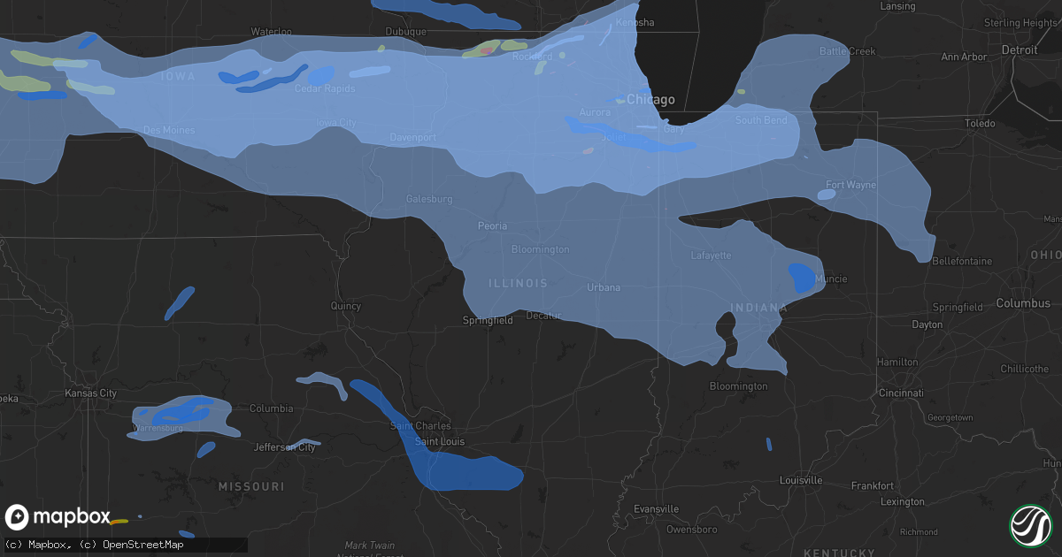
August 10 map
$229
one time, instant access
Download today. No call, no setup
Keep the $229
Bought the map and want the full workflow? Apply the entire $229 to a subscription within 7 days. None of it is wasted.
Every map, not just this one
This buys you this map. Subscription and you get every map we run, in the markets you choose from a few cities to whole states to nationwide. Plus real-time alerts the moment a storm fires.
Contact data
Name, contact info, occupancy, even credit band for addresses in the footprint. You go from where it hit to who to call.
Become the source they trust
Unlimited branding weather history reports on demand. You already have the documented answer ready for the property owner, and you are the one who showed up with it.
Property data and RoofTrace estimates
Pull up any address you have got, its value and the exact code rules for that jurisdiction, straight from One Click Code. Then RoofTrace estimates the squares, pitch, and roof value, priced the way you price.
Storm reports in Illinois
Illinois
| Date | Description |
|---|---|
| 08/10/20206:41 PM CDT | Roof damage to supermarket. |
| 08/10/20206:37 PM CDT | 4 to 5 inch tree limbs down... Power lines down. Wind gusts estimated at 50 mph. |
| 08/10/20206:37 PM CDT | Strong winds out ahead of a thunderstorm as a gust front. Small and medium size tree branches down. Winds estimated to be about 50-55 mpr. |
| 08/10/20206:20 PM CDT | Powerlines down. |
| 08/10/20206:19 PM CDT | 12-14 inch tree limb over paula drive. |
| 08/10/20206:13 PM CDT | A local report indicates 60 MPH wind near 1 ENE CAHOKIA |
| 08/10/20206:00 PM CDT | Large tree down blocking the roadway near intersection of spring st and lebanon road. |
| 08/10/20205:49 PM CDT | Powerline down. |
| 08/10/20205:42 PM CDT | Tree down. |
| 08/10/20205:37 PM CDT | 4 inch diameter tree limb down with the gust front. |
| 08/10/20205:36 PM CDT | 2 inch tree limb blown down. |
| 08/10/20205:27 PM CDT | Large tree limbs snapped |
| 08/10/20205:14 PM CDT | A local report indicates 60 MPH wind near COLES COUNTY AIRPORT |
| 08/10/20205:09 PM CDT | Corrected time |
| 08/10/20205:05 PM CDT | Tree limb down. |
| 08/10/20204:50 PM CDT | Numerous trees and power lines down throughout danville. Several streets blocked. |
| 08/10/20204:43 PM CDT | A local report indicates 75 MPH wind near 2 NNW DANVILLE |
| 08/10/20204:40 PM CDT | Two large trees down blocking us 150. |
| 08/10/20204:30 PM CDT | Arps mesonet |
| 08/10/20204:25 PM CDT | Tree down on a house |
| 08/10/20204:25 PM CDT | Wind gusts estimated at 50-60mph. |
| 08/10/20204:25 PM CDT | Tree down on a garage |
| 08/10/20204:25 PM CDT | A local report indicates 60 MPH wind near WILLARD AIRPORT |
| 08/10/20204:25 PM CDT | Private weather station observed 73 mph gust west of kentland. Time estimated by radar. |
| 08/10/20204:23 PM CDT | A local report indicates 61 MPH wind near DECATUR AIRPORT |
| 08/10/20204:20 PM CDT | Private weather station observed 66 mph gust west of kentland. Time estimated by radar. |
| 08/10/20204:20 PM CDT | Two large trees down. Shingles damaged. |
| 08/10/20204:18 PM CDT | A local report indicates 60 MPH wind near 1 ESE NAPERVILLE |
| 08/10/20204:10 PM CDT | Tree blocking kezie blvd at logan blvd in logan square neighborhood of chicago. |
| 08/10/20204:10 PM CDT | Tree fell on house |
| 08/10/20204:10 PM CDT | 12 inch limb down. Time estimated by radar. |
| 08/10/20204:09 PM CDT | Public report of tree damage in cicero. |
| 08/10/20204:08 PM CDT | Trained spotter estimates winds of 60 mph in thornton. Relayed via amateur radio. |
| 08/10/20204:07 PM CDT | Delayed report. |
| 08/10/20204:07 PM CDT | Delayed report. |
| 08/10/20204:05 PM CDT | Measured wind gust of 72 mph near fir street relayed via amateur radio. |
| 08/10/20204:05 PM CDT | Large trees downed. Time estimated by radar. |
| 08/10/20204:04 PM CDT | An ef-0 tornado with path length of 1.5 miles... Max width 250 yards... And peak winds of 80 mph started just northwest of grant park on n 11000 e road... Traveled sout |
| 08/10/20204:03 PM CDT | Numerous trees snapped and uprooted in evanston. Time estimated by radar. |
| 08/10/20204:03 PM CDT | Large tree snapped. Time estimated by radar. |
| 08/10/20204:02 PM CDT | 45 foot pine tree downed. Time estimated by radar. |
| 08/10/20204:02 PM CDT | Additional info on previous tornado report from 1 nnw west ridge - chicago. Additional video shared with nws shows tornado in rogers park neighborhood of chicago that e |
| 08/10/20204:00 PM CDT | Widespread wind damage throughout steger including trees down... Trees on power lines... And power poles broken. |
| 08/10/20204:00 PM CDT | Numerous reports of downed tree limbs across wrigleyville... Roscoe village... Logan square... And lincoln square. Time estimated by radar. |
| 08/10/20204:00 PM CDT | An nws storm survey determined a region of enhanced straight line winds occurred in and around the harvey area. Downed utility poles and snapped trees indicate wind spe |
| 08/10/20204:00 PM CDT | Tree damage near 7500s road west of st anne. Time estimated by radar. |
| 08/10/20204:00 PM CDT | Tree down across a road. Time estimated by radar. Delayed report. |
| 08/10/20204:00 PM CDT | Possible structure damage near 18th and canalport avenue in chicago. |
| 08/10/20204:00 PM CDT | Extensive damage to trees reported in the area along 149th and 150th in harvey... Especially east of dixie hwy. Possible tornado. |
| 08/10/20204:00 PM CDT | Large trees and power poles down across entire county. Also reported billboard damage. Time estimated by radar. |
| 08/10/20203:59 PM CDT | Large tree uprooted in oak lawn. Time estimated by radar. |
| 08/10/20203:59 PM CDT | An nws damage survey confirmed an ef-1 tornado with estimated peak winds of 110 mph... Path length of 3 miles... And max width of 300 yards touched down near crawford a |
| 08/10/20203:57 PM CDT | Reported at 2105 w eastwood dr... Chicago... Il. Large tree down and large branches broken out of other trees. |
| 08/10/20203:57 PM CDT | 50 to 60 foot tall trees downed. Time estimated by radar. |
| 08/10/20203:57 PM CDT | Midway asos peak gust. |
| 08/10/20203:57 PM CDT | Reports of a roof blown off a building north of addison and lake shore drive. |
| 08/10/20203:57 PM CDT | Bricks knocked off top of building and trees downed. Time estimated by radar. |
| 08/10/20203:57 PM CDT | 6-8 inch tree limbs down |
| 08/10/20203:57 PM CDT | Nws storm survey determined that a brief tornado touched down very close to the cook/will county line near shabbona drive. It tracked northeast where it produced a loca |
| 08/10/20203:57 PM CDT | Measured by weatherbug station. |
| 08/10/20203:55 PM CDT | Private weather station observed 66 mph wind gust. |
| 08/10/20203:55 PM CDT | Also had pea size hail. |
| 08/10/20203:54 PM CDT | A tornado touched down just east of south harlem avenue in oak forest... Then moved nearly due east along 151st street producing mainly minor tree and structural damage |
| 08/10/20203:53 PM CDT | Overturned semi at milepost 287 on southbound i-57. Time estimated by radar. |
| 08/10/20203:53 PM CDT | The emergency manager relayed reports of trees uprooted across the entire county. Time estimated by radar. |
| 08/10/20203:53 PM CDT | Large tree down on road. |
| 08/10/20203:52 PM CDT | Small garage partially collapsed. Time estimated by radar. |
| 08/10/20203:51 PM CDT | Measured with handheld anemometer |
| 08/10/20203:50 PM CDT | Two large trees were blown down...one of which fell onto a grain bin. |
| 08/10/20203:50 PM CDT | Overturned semi trailer on i-57 near mile marker 287. |
| 08/10/20203:50 PM CDT | Small trees down across town... All in the same direction. Time estimated by radar. |
| 08/10/20203:50 PM CDT | Power lines down at 9th and carpenter. Time estimated by radar. |
| 08/10/20203:50 PM CDT | Garage collapsed. Reported at nordica and roscoe. |
| 08/10/20203:48 PM CDT | Measured wind gust. Small trees downed. Time estimated by radar. |
| 08/10/20203:46 PM CDT | Trained spotter reported hundreads of trees snapped and uprooted along cedar road and joliet highway. |
| 08/10/20203:45 PM CDT | Power line down due to 36 inch diameter tree being uprooted. Tree was partially rotten in the middle. Time estimated by radar. |
| 08/10/20203:45 PM CDT | Power poles down on s 9th st. |
| 08/10/20203:45 PM CDT | Power poles damaged |
| 08/10/20203:45 PM CDT | A local report indicates 58 MPH wind near W SPRINGFIELD |
| 08/10/20203:45 PM CDT | 18 inch diameter tree uprooted. |
| 08/10/20203:45 PM CDT | Numerous traffic signals and a large tree damaged near delaney road and cedar road. Time estimated by radar. |
| 08/10/20203:43 PM CDT | Trained spotter reports quarter sized hail near roosevelt road and il-53. |
| 08/10/20203:43 PM CDT | Numerous large trees uprooted. Time estimated by radar. |
| 08/10/20203:41 PM CDT | Peak wind gust measured at nws chicago. Small tree limbs observed flying past window at time of wind gust. |
| 08/10/20203:40 PM CDT | 4-5 block area of widespread tree damage. 8 inch and larger diameter branches broken... Some trees snapped near the top. Relayed via amateur radio. |
| 08/10/20203:40 PM CDT | Considerable tree damage along main st north of 75th street. |
| 08/10/20203:40 PM CDT | 8-10 inch diameter limbs downed in the vicinity of sullivan lake road and game trail. Some branches were up to 20 feet in length. Time estimated by radar. |
| 08/10/20203:40 PM CDT | Trained spotter reports numerous 6 inch diameter healthy tree limbs down with several whole trees uprooted. |
| 08/10/20203:40 PM CDT | Public reports large limbs downed. Time estimated by radar. |
| 08/10/20203:40 PM CDT | Report of estimated winds up to 50mph... Small branches downed... And hail to half inch diameter. |
| 08/10/20203:40 PM CDT | 10 inch tree down and eight inch tree branches down |
| 08/10/20203:39 PM CDT | Corrects previous tornado report from 1 nne lombard. The same storm which produced the brief wheaton tornado produced another region of ef-1 tornado damage immediately |
| 08/10/20203:39 PM CDT | Estimated 60 to 70 mph winds. Time estimated by radar. |
| 08/10/20203:39 PM CDT | Large tree limbs and small trees down. Time estimated by radar. |
| 08/10/20203:38 PM CDT | Kdpa west chicago - dupage arpt. |
| 08/10/20203:38 PM CDT | Dupage asos peak gust. |
| 08/10/20203:36 PM CDT | Structural damage to the roof of wheaton college church. Relayed via social media. Time estimated by radar. |
| 08/10/20203:36 PM CDT | Rolled over b-class truck with trailer at irving park road and schaumburg road. |
| 08/10/20203:36 PM CDT | 12 inch diameter tree down on house. Time estimated by radar. |
| 08/10/20203:36 PM CDT | An nws damage survey determined a corridor of enhanced straight line winds damaged trees and utility poles with the most concentrated damage east of north main street t |
| 08/10/20203:35 PM CDT | Trained spotter reports 1-6 in diameter tree branches down all over warrenville. |
| 08/10/20203:35 PM CDT | Corrects previous tornado report from 1 ene wheaton. A very brief ef-1 tornado touched down near the intersection of seminary avenue and scott street before moving nort |
| 08/10/20203:35 PM CDT | Kc09 morris airport. |
| 08/10/20203:34 PM CDT | Six inch diameter tree limb down. Time estimated by radar. |
| 08/10/20203:33 PM CDT | Public reports trees down near caton farm road and drauden road. |
| 08/10/20203:32 PM CDT | Measured by weatherbug station. |
| 08/10/20203:31 PM CDT | Large trees and power lines down across plainfield. Time estimated by radar. |
| 08/10/20203:30 PM CDT | Power pole in ameren parking lot fell on car. |
| 08/10/20203:30 PM CDT | 8-in diameter branches down near i-55 and caton farm road. Relayed via amateur radio. Time estimated by radar. |
| 08/10/20203:30 PM CDT | Video relayed via social media of tree damage in forrest. |
| 08/10/20203:30 PM CDT | Law enforcement reports golfball sized hail near i-80 and lisbon road. |
| 08/10/20203:30 PM CDT | Damage to siding of a house. Small branches downed in the vicinity. Time estimated by radar. |
| 08/10/20203:30 PM CDT | Tree over 12 inches in diameter snapped. Near us-12 and il-173. |
| 08/10/20203:29 PM CDT | 14 inch diameter tree split in half. Power lines downed. Time estimated by radar. |
| 08/10/20203:28 PM CDT | Eight inch tree limbs down |
| 08/10/20203:27 PM CDT | Tree down on car. |
| 08/10/20203:27 PM CDT | Tree down on road near nancy ln and powis rd in wayne. |
| 08/10/20203:27 PM CDT | Time estimated by radar. |
| 08/10/20203:20 PM CDT | A local report indicates 64 MPH wind near BLOOMINGTON AIRPORT |
| 08/10/20203:20 PM CDT | Several trees and large branches down. Time estimated by radar. |
| 08/10/20203:20 PM CDT | Tree damage blocking fays lane west of sugar grove. Time estimated by radar. |
| 08/10/20203:20 PM CDT | 10 inch diameter tree snapped. Time estimated by radar. |
| 08/10/20203:17 PM CDT | Numerous metal farm buildings damaged including roofs and metal sidings blown off. Also... Large tree snapped and downed onto a house. Time estimated by radar. |
| 08/10/20203:16 PM CDT | Large branch of a linden tree blown down by thunderstorm wind gust along east side of hershey street north of the clearwater intersection. |
| 08/10/20203:16 PM CDT | A local report indicates 62 MPH wind near 2 W SUGAR GROVE |
| 08/10/20203:16 PM CDT | Aurora asos peak gust. |
| 08/10/20203:16 PM CDT | Numerous mature branches down near veterans and bloomington road. |
| 08/10/20203:16 PM CDT | A live 4 inch diameter 18 foot long silver maple branch blew down in back yard of a house on gill street. Northwest wind gust estimated at 65 mph. |
| 08/10/20203:15 PM CDT | 4 inch diameter branch downed and damage to traffic signals at il-38 and meredith road. Time estimated by radar. |
| 08/10/20203:15 PM CDT | 20 inch tree limb down. No structural damage reported. Time estimated. |
| 08/10/20203:15 PM CDT | 8 inch diameter tree snapped near il-47 and nottingham. Relayed via nws chat... Time estimated by radar. |
| 08/10/20203:15 PM CDT | Trained spotter reports widespread tree and power line damage across somanauk. Trees up to 4-6 diameter snapped at the base. |
| 08/10/20203:15 PM CDT | Tree down on house at 1st and 4th st. Tree branches down at 5th and atlanta. |
| 08/10/20203:15 PM CDT | An ef-1 tornado with peak winds of 105 mph... Path length of 14.5 miles... And max width of 250 yards started on the south side of yorkville destroying a pergola... Tak |
| 08/10/20203:14 PM CDT | Private weather station recorded 65 mph wind gust. |
| 08/10/20203:12 PM CDT | A local report indicates 58 MPH wind near TOWANDA |
| 08/10/20203:12 PM CDT | Drone footage reveals a narrow swath of corn likely around 40 yards across flattened in a convergent pattern. In addition... Damage to a barn was noted... With a near c |
| 08/10/20203:11 PM CDT | Large tree limb down |
| 08/10/20203:10 PM CDT | Multiple trees and power lines down... Including 10 and 20 inch in diameter trees. Fences also blown down. Time estimated by radar. |
| 08/10/20203:10 PM CDT | Downed power lines caused a four acre field fire |
| 08/10/20203:06 PM CDT | A local report indicates 80 MPH wind near 3 E SOUTH PEKIN |
| 08/10/20203:06 PM CDT | 10 inch diameter tree branches down |
| 08/10/20203:05 PM CDT | An ef-1 tornado with peak winds of 95 mph and path length of 5.7 miles touched down on harmony road southwest of i-90 and continued northeast before lifting near dunham |
| 08/10/20203:05 PM CDT | Multiple trees and power lines down. Estimated 60 mph gusts. |
| 08/10/20203:04 PM CDT | Large tree down onto powerlines. Numerous large branches/limbs down. Shed destroyed. Time estimated by radar. |
| 08/10/20203:02 PM CDT | Several trees snapped and uprooted. Time estimated by radar. |
| 08/10/20203:00 PM CDT | Grain bin damaged |
| 08/10/20203:00 PM CDT | Rockford fire chief reports at least 150 damaged power poles across the city. |
| 08/10/20203:00 PM CDT | A local report indicates 1.00 inch wind near 1 WNW BELVIDERE |
| 08/10/20203:00 PM CDT | Large tree down blocking a road |
| 08/10/20202:59 PM CDT | A brief ef-1 tornado with peak winds of 100 mph... Path length of 0.75 miles... And max width of 150 yards impacted the north side of ottawa damaging roofing material a |
| 08/10/20202:59 PM CDT | An nws damage survey found widespread tree damage with a few trees snapped very near their base. Seven large and new utility poles were also snapped about 10 feet up fr |
| 08/10/20202:58 PM CDT | Measured wind gusts between 55-62mph occurred between 250 and 258pm. |
| 08/10/20202:56 PM CDT | Live tree... Over one foot in diameter... Blown down. |
| 08/10/20202:56 PM CDT | Reports of damage to roofs and outside structuers in utica. Time estimated by radar. |
| 08/10/20202:55 PM CDT | Tree down and damage to a metal structure. Time estimated by radar. |
| 08/10/20202:54 PM CDT | Drone footage shows a narrow swath of corn flattened in a convergent pattern. This brief ef-0 tornado crossed buck road and pearl street before lifting in a field east |
| 08/10/20202:53 PM CDT | Power lines downed... And corn flattened. Time estimated by radar. |
| 08/10/20202:53 PM CDT | Estimated 70 to 80 mph winds and dime size hail. |
| 08/10/20202:53 PM CDT | Multiple large tree limbs... Approximately 20 feet long... Down. Power lines also down. Some streets blocked by downed trees. No structural damage reported. |
| 08/10/20202:53 PM CDT | A local report indicates 1.00 inch wind near 4 NNW CHERRY VALLEY |
| 08/10/20202:52 PM CDT | Farm and fleet on east riverside road in loves park lost a good portion of its roof. |
| 08/10/20202:50 PM CDT | Large trees snapped and large limbs down on the rock valley college campus. Time estimated by radar. |
| 08/10/20202:50 PM CDT | Photos show tree damage and flattened crops along buck road north of kirkland. Time estimated by radar. |
| 08/10/20202:50 PM CDT | Six inch tree branches blown down |
| 08/10/20202:50 PM CDT | A local report indicates 65 MPH wind near 1 S MORTON |
| 08/10/20202:48 PM CDT | Power lines blown down... Power out in town. |
| 08/10/20202:48 PM CDT | Large tree blown down. Power lines also down. |
| 08/10/20202:48 PM CDT | Large tree limbs downed. Time estimated by radar. |
| 08/10/20202:47 PM CDT | A very brief tornado with peak winds of 75 mph and path length of 1.5 miles touched down near the intersection of pierpont ave and montague road and continued northeast |
| 08/10/20202:47 PM CDT | Power pole snapped near jefferson and westshore |
| 08/10/20202:47 PM CDT | An ef-1 tornado with peak winds of 100 mph and path length of 9.2 touched down just north of rockford college and traveled northeast into caledonia. Significant tree da |
| 08/10/20202:46 PM CDT | Thunderstorm downed large tree on the property of a manufactured home and impaled a small branch from this into one of the walls. Time estimated from radar. |
| 08/10/20202:46 PM CDT | 6 inch diameter tree limb down. Estimated winds of 60 to 70 mph. Time of the event was estimated using radar. |
| 08/10/20202:45 PM CDT | Trained spotter reports widespread tree damage in rockford. Medium to large branches and trees snapped. |
| 08/10/20202:45 PM CDT | Corrects previous tstm wnd gst report from mendota. Wind gusts to severe limits were frequent for 30 minutes after they started. The peak gust was estimated to be aroun |
| 08/10/20202:45 PM CDT | Two large trees... Approximately 10 inches in diameter... Blown down. |
| 08/10/20202:45 PM CDT | Trees down |
| 08/10/20202:45 PM CDT | In rockford... Lots of downed trees... Power lines and poles... And fences northeast of the area from near the north alpine and guilford intersection thru shaw woods to |
| 08/10/20202:45 PM CDT | Tree down on powerlines on fairview drive. Time estimated by radar. |
| 08/10/20202:45 PM CDT | 1 foot diameter branch downed. Winds estimated at 60 mph. Time estimated by radar. |
| 08/10/20202:44 PM CDT | Tree down on powerlines on heuermann rd. Time estimated by radar. |
| 08/10/20202:43 PM CDT | A local report indicates 59 MPH wind near PEORIA INTERNATIONAL AI |
| 08/10/20202:43 PM CDT | *** 1 inj *** corrects previous tstm wnd dmg report from 2 n peru for including one injury that was the truck driver... As reported by area radio station wlpo. Semi tra |
| 08/10/20202:42 PM CDT | Roof blown off a large shed |
| 08/10/20202:42 PM CDT | A local report indicates 65 MPH wind near SPRING BAY |
| 08/10/20202:42 PM CDT | Many 6 inch diameter tree branches down. |
| 08/10/20202:40 PM CDT | Multiple trees and power lines down. Tree down on a house... Residents had to be helped out of home. |
| 08/10/20202:40 PM CDT | Wind gusts up to 60mph lasted for approximately five minutes. |
| 08/10/20202:40 PM CDT | Several trees and fences blown down |
| 08/10/20202:40 PM CDT | Trees and power lines down on 2nd street. |
| 08/10/20202:40 PM CDT | Tree fell on house on main st. Many 6-8 inch diameter branches down. School st blocked by downed trees. |
| 08/10/20202:40 PM CDT | Two trees broken near the base |
| 08/10/20202:40 PM CDT | Tree down on graham chapel road and il route 78. |
| 08/10/20202:40 PM CDT | Large limb down. Time estimated by radar. |
| 08/10/20202:40 PM CDT | Tree damage... Power lines down... 2 semis overturned... Snapped traffic signs... And roof damage to homes reported. Time estimated by radar. |
| 08/10/20202:40 PM CDT | Large tree limb down. Time estimated by radar. |
| 08/10/20202:40 PM CDT | Roof damage to middle school. Reported by week-tv. |
| 08/10/20202:39 PM CDT | Private weather station observed 92 mph wind gust just south of dixon at 2:39 pm. 20-30 minutes of winds gusting more than 50mph. |
| 08/10/20202:38 PM CDT | Part of the germantown hills middle school roof was blown off. Delayed report. |
| 08/10/20202:37 PM CDT | Picnic shelter destroyed. Delayed report. |
| 08/10/20202:37 PM CDT | Two trees blown down. One resulted in a road being blocked. |
| 08/10/20202:35 PM CDT | Multiple tree limbs down and power pole partially down on 5400 block of galena road. Delayed report. |
| 08/10/20202:35 PM CDT | Damage to a home under construction |
| 08/10/20202:35 PM CDT | A porch roof was blown off on the west side of canton. |
| 08/10/20202:35 PM CDT | Large billboard was blown over near the intersection of gift avenue and sheridan road. Steel beams supporting the billboard bent about halfway. Delayed report. |
| 08/10/20202:35 PM CDT | Eight inch tree limbs down at war memorial drive and grave ave. Delayed report. |
| 08/10/20202:35 PM CDT | 8 inch diameter tree blown down. Delayed swop report. |
| 08/10/20202:32 PM CDT | Tree fell on house |
| 08/10/20202:30 PM CDT | A local report indicates 61 MPH wind near HANNA CITY |
| 08/10/20202:30 PM CDT | Tree snapped at base |
| 08/10/20202:30 PM CDT | 3-4 inch tree branches down... Time estimated from radar. |
| 08/10/20202:29 PM CDT | Eight inch tree down on house on 3300 block alta lane. Delayed report. |
| 08/10/20202:28 PM CDT | Large tree uprooted |
| 08/10/20202:25 PM CDT | Branches and trees were reported down in the city of freeport. |
| 08/10/20202:25 PM CDT | Tree was on home at 4th st and birch and tree branches on home at 5th and birch. Delayed report. |
| 08/10/20202:25 PM CDT | Delayed report. Numerous power poles snapped in princeton. Time estimated. |
| 08/10/20202:25 PM CDT | Several branches down. Exterior side of house peeled away. |
| 08/10/20202:25 PM CDT | Delayed report. 150 foot communications tower collapsed. Tower was rated to 90 mph. Time estimated. |
| 08/10/20202:23 PM CDT | Reported wind gusts of 50-60 mph. Wind gusts remained at this level for about five minutes. |
| 08/10/20202:22 PM CDT | Tree branch took down powerlines in lena. |
| 08/10/20202:20 PM CDT | 1700 people without power in the county... Many in the city of the freeport. Numerous streets are blocked due to down trees and power lines. The time of the event was e |
| 08/10/20202:20 PM CDT | Ten inch tree across il-78 near graham chapel road. Delayed report. |
| 08/10/20202:18 PM CDT | *** 5 inj *** updates previous tstm wnd dmg report from forreston. Multiple trailers blown over by wind and numerous trees down in forreston. Relayed by emergency manag |
| 08/10/20202:15 PM CDT | Report was delayed. Pictures via social media of large tree limbs down with one about 12 inches in diameter and others smaller. |
| 08/10/20202:15 PM CDT | Several tree limbs snapped based on photo about 4 to 6 inches in diameter. Trampoline was blown over on its side. Time of the event was estimated based on radar and dur |
| 08/10/20202:15 PM CDT | Several power lines and trees blown down between 210-220pm. |
| 08/10/20202:15 PM CDT | Tree limbs down about 4 to 6 inches in diameter or larger in morrison. Time of the event was estimated using radar. |
| 08/10/20202:15 PM CDT | Several power lines and trees blown down between 210-220pm. |
| 08/10/20202:15 PM CDT | Several power lines and trees blown down between 210-220pm. |
| 08/10/20202:15 PM CDT | Several power lines and trees blown down between 210-220pm. |
| 08/10/20202:15 PM CDT | *** 5 inj *** updates previous tstm wind dmg report from forreston. Several trailers were damaged or destroyed. Significant damage was done to a metal building near the |
| 08/10/20202:12 PM CDT | A tornado moved through cropland just south of freeport. The tornado began just west of florence... And moved n/ne for about 4.5 miles before dissipating at the souther |
| 08/10/20202:10 PM CDT | Delayed report with time estimated from radar. Widespread tree damage in village with power lines down. Roof of fire house gone. |
| 08/10/20202:05 PM CDT | Large tree fell down and onto the power lines. Both are lying across the street. Smaller branches and limbs can also be seen through the streets. |
| 08/10/20202:00 PM CDT | Several power lines and tree branches down. |
| 08/10/20202:00 PM CDT | 4 to 6 inch tree limb down. Picture via social media. |
| 08/10/20201:55 PM CDT | Home weather station reported 58 mph gusts and pea sized hail. |
| 08/10/20201:53 PM CDT | Via social media...two large tree limbs down in their yard. Time estimated using radar and duration. |
| 08/10/20201:50 PM CDT | Several trees and powerlines down in town. Time of the event was estimated using radar. |
| 08/10/20201:48 PM CDT | A local report indicates 79 MPH wind near MOLINE QUAD-CITY AIRPOR |
| 08/10/20201:46 PM CDT | Corrects previous tstm wnd dmg report from nora to correct the time. 6 inch diameter tree limb down. Estimated winds of 60 to 70 mph. Time of the event was estimated us |
| 08/10/20201:45 PM CDT | Numerous photos of trees down in port byron via social media. Time of the event was estimated using radar. |
| 08/10/20201:45 PM CDT | Many trees uprooted and snapped. Some building damage downtown was also noted. |
| 08/10/20201:44 PM CDT | Tree limbs down near south park mall. |
| 08/10/20201:40 PM CDT | Reported that a few trees were down in little work as well as power lines. Time of the event was estimated using radar. |
| 08/10/20201:35 PM CDT | Several large tree limbs are down |
| 08/10/20201:35 PM CDT | Reported at freeport... Il. |
| 08/10/20201:35 PM CDT | A local report indicates 77 MPH wind near MOLINE QUAD-CITY AIRPOR |
| 08/10/20201:35 PM CDT | Estimated time by radar. Large tree limbs down and on top of houses. |
| 08/10/20201:35 PM CDT | Large tree was uprooted in a front yard... Pulling up a lot of the ground and concrete there. |
| 08/10/20201:33 PM CDT | Via social media. Old barn and other out buildings with roofs ripped off. Time of the event was estimated using radar. |
| 08/10/20201:30 PM CDT | Location estimated. Tree snapped |
| 08/10/20201:28 PM CDT | A local report indicates 60 MPH wind near 3 WNW OAK GROVE |
| 08/10/20201:28 PM CDT | A local report indicates 68 MPH wind near MOLINE QUAD-CITY AIRPOR |
| 08/10/20201:25 PM CDT | Large tree snapped and fell into a house... Actually breaking through the ceiling and leading to damage to the house. |
| 08/10/20202:31 AM CDT | At 730 PM CDT, severe thunderstorms were located along a line extending from 6 miles north of Mount Vernon to 6 miles northeast of Rend Lake Area to near Valier, moving east at 65 mph. HAZARD...70 mph wind gusts. SOURCE...Radar indicated. IMPACT...Expect considerable tree damage. Damage is likely to mobile homes, roofs, and outbuildings. Locations impacted include... Fairfield, Mcleansboro, Wayne City, Dahlgren, Sims, Keenes, Macedonia and Belle Prairie City.This includes Interstate 64 in Illinois between Mile Markers 91 and108. |
| 08/10/20202:11 AM CDT | At 711 PM CDT, severe thunderstorms were located along a line extending from near Irvington to 7 miles northwest of Tamaroa, moving east at 65 mph. HAZARD...60 mph wind gusts. SOURCE...Radar indicated. IMPACT...Expect damage to roofs, siding, and trees. Locations impacted include... Mount Vernon, Benton, Christopher, Rend Lake Area, Sesser, Woodlawn, Bluford, Valier, West City, Ina, North City, Buckner, Dix, Waltonville, Bonnie, Belle Rive, Ewing and Nason.This includes the following highways... Interstate 57 in Illinois between Mile Markers 70 and 105. Interstate 64 in Illinois between Mile Markers 63 and 90. |
| 08/10/20201:56 AM CDT | At 655 PM CDT, severe thunderstorms were located along a line extending from near Albers to near Lively Grove to Sparta, moving east at 50 mph. HAZARD...60 mph wind gusts. SOURCE...Emergency management reported roof damage to a store in Marissa. IMPACT...Expect damage to roofs, siding, and trees. Locations impacted include... Nashville, Centralia, Okawville, Wamac, Irvington, Ashley, Posen, Bartelso, Beaucoup, Hoyleton, Hoffman, Covington, Richview, Addieville, Oakdale, Radom, New Minden, Du Bois, Huegely and Cordes.This includes Interstate 64 in Illinois between exits 41 and 61. |
| 08/10/20201:49 AM CDT | At 648 PM CDT, severe thunderstorms were located along a line extending from 7 miles southwest of New Memphis to Baldwin to near Evansville, moving east at 50 mph. HAZARD...60 mph wind gusts. SOURCE...Radar indicated. IMPACT...Expect damage to roofs, siding, and trees. Locations impacted include... Du Quoin, Pinckneyville, Tamaroa, Willisville, Cutler and St. Johns. |
| 08/10/20201:35 AM CDT | Several large tree limbs are down |
| 08/10/202012:46 AM CDT | At 546 PM CDT, severe thunderstorms were located along a line extending from 6 miles southeast of Dennison to near Casey, moving southeast at 20 mph. HAZARD...60 mph wind gusts. SOURCE...Radar indicated. IMPACT...Expect damage to roofs, siding, and trees. Locations impacted include... Marshall, Casey, Martinsville, Clarksville, West Union, Dennison, Darwin, Orange and Lincoln Trail State Park.This includes Interstate 70 between mile markers 128 and 154. |
| 08/10/202012:19 AM CDT | At 519 PM CDT, severe thunderstorms were located along a line extending from near Cowden to near Litchfield, moving southeast at 45 mph. HAZARD...60 mph wind gusts and quarter size hail. SOURCE...Radar indicated. IMPACT...Hail damage to vehicles is expected. Expect wind damage to roofs, siding, and trees. Locations impacted include... Vandalia, Greenville, Litchfield, Hillsboro, Nokomis, St. Elmo, Ramsey, Witt, Pocahontas, Brownstown, Taylor Springs, Coffeen, Mulberry Grove, Schram City, Tamalco, Farina, Sorento, Beaver Creek, Shobonier and Woburn.This includes the following highways... Interstate 70 in Illinois between exits 36 and 76. Interstate 55 in Illinois near exit 52. Interstate 57 in Illinois near exit 135.This also includes Ramsey Lake State Park and Lake Lou Yaeger. |
| 08/09/202011:56 PM CDT | At 456 PM CDT, severe thunderstorms were located along a line extending from near Greenfield to Davis to near Bellflower, moving southeast at 25 mph. HAZARD...60 mph wind gusts. SOURCE...Radar indicated. IMPACT...Expect damage to roofs, siding, and trees. Locations impacted include... Florissant, Granite City, Alton, Hazelwood, Edwardsville, Godfrey, Glen Carbon, Wood River, Troy, Bethalto, Jerseyville, Black Jack, Staunton, Gillespie, Elsberry, St. Paul, Spanish Lake, East Alton, Moscow Mills and Carrollton.This includes Interstate 55 in Illinois between exits 23 and 44. This also includes Cuivre River State Park, Confluence State Park,Pere Marquette State Park, and Beaver Dam State Park. |
| 08/09/202011:49 PM CDT | At 448 PM CDT, severe thunderstorms were located along a line extending from 7 miles northeast of Danville to near Allerton, moving east at 40 mph. HAZARD...70 mph wind gusts. SOURCE...Emergency management. IMPACT...Expect considerable tree damage. Damage is likely to mobile homes, roofs, and outbuildings. Locations impacted include... Danville, Georgetown, Westville, Tilton, Catlin, Ridge Farm, Sidell, Belgium, Bismarck, Indianola, Jamaica, Vermilion County Airport, Alvin and Kickapoo State Park.This includes Interstate 74 between mile markers 209 and 219. |
| 08/09/202011:29 PM CDT | At 429 PM CDT, severe thunderstorms were located along a line extending from Allerton to near Assumption, moving east at 70 mph. HAZARD...70 mph wind gusts. SOURCE...Radar indicated. IMPACT...Expect considerable tree damage. Damage is likely to mobile homes, roofs, and outbuildings. Locations impacted include... Charleston, Mattoon, Taylorville, Shelbyville, Tuscola, Sullivan, Pana, Arcola, Villa Grove, Arthur, Moweaqua, Kincaid, Bethany, Atwood, Assumption, Macon, Lovington, Morrisonville, Stonington and Oakland.This includes Interstate 57 between mile markers 182 and 219. |
| 08/09/202011:25 PM CDT | At 424 PM CDT, an area of severe thunderstorms was located along a line extending from near Browns Lake to Racine, moving east at 20 mph. HAZARD...60 mph wind gusts and penny size hail. SOURCE...Radar indicated. IMPACT...Expect damage to roofs, siding, and trees. Locations impacted include... Kenosha, Racine, Mount Pleasant, Pleasant Prairie, Antioch, Sturtevant, Union Grove, Paddock Lake, Camp Lake, Wind Lake, Winthrop Harbor, Rochester, Raymond, Wheatland, Yorkville, Silver Lake, Wind Point, Channel Lake, Lake Catherine and Browns Lake.This replaces the Severe Thunderstorm Warning that was previously in effect for Racine and Kenosha Counties. |
| 08/09/202010:39 PM CDT | At 339 PM CDT, severe thunderstorms were located along a line extending from near Lake Geneva to Round Lake Park, moving northeast at 45 mph. HAZARD...60 mph wind gusts and nickel size hail. SOURCE...Radar indicated. IMPACT...Expect damage to roofs, siding, and trees. Locations impacted include... Kenosha, Racine, Mount Pleasant, Pleasant Prairie, Antioch, Sturtevant, Union Grove, Paddock Lake, Camp Lake, Winthrop Harbor, Rochester, Wheatland, Yorkville, Silver Lake, Channel Lake, Lake Catherine, Powers Lake, Browns Lake, Eagle Lake and Twin Lakes. |
| 08/09/202010:25 PM CDT | At 325 PM CDT, severe thunderstorms were located along a line extending from near Gardner to Fairbury to Bloomington, moving southeast at 60 mph. HAZARD...60 mph wind gusts. SOURCE...Radar indicated. IMPACT...Expect damage to roofs, siding, and trees. Locations impacted include... Watseka, Paxton, Gibson City, Gilman, Clifton, Milford, Onarga, Sheldon, Chebanse, Cissna Park, Piper City, Ashkum, Buckley, Martinton, Stockland, Crescent City, Danforth, Melvin, Loda and Beaverville.Including the following interstate... I-57 between mile markers 258 and 301. |
| 08/09/202010:13 PM CDT | At 312 PM CDT, severe thunderstorms were located along a line extending from near Clinton to near Marengo, moving east at 40 mph. HAZARD...60 mph wind gusts and nickel size hail. SOURCE...Radar indicated. IMPACT...Expect damage to roofs, siding, and trees. Locations impacted include... Elkhorn, Delavan, Lake Geneva, Williams Bay, Camp Lake, Rochester, Wheatland, Genoa City, Walworth, Silver Lake, Clinton, Fontana-On-Geneva Lake, Sharon, Darien, Powers Lake, Browns Lake, Como, Pell Lake, Twin Lakes and Bohners Lake. |
| 08/09/202010:09 PM CDT | At 308 PM CDT, severe thunderstorms were located along a line extending from near Memphis to near Lewistown, moving northeast at 40 mph. HAZARD...60 mph wind gusts and quarter size hail. SOURCE...Radar indicated. IMPACT...Hail damage to vehicles is expected. Expect wind damage to roofs, siding, and trees. Locations impacted include... Kahoka, Memphis, Wayland, Wyaconda, Rutledge, Luray, South Gorin, Granger, Winchester, Revere, Arbela, Gregory Landing, Clark County Fairgrounds, Chambersburg, Ashton, Heath Memorial Conservation Area, Prospect Grove, Peaksville, Scotland County Fairgrounds and Fairmont. |
| 08/09/20209:50 PM CDT | At 250 PM CDT, severe thunderstorms were located along a line extending from near Roanoke to near St. David, moving southeast at 30 mph. HAZARD...70 mph wind gusts. SOURCE...Radar indicated. IMPACT...Expect considerable tree damage. Damage is likely to mobile homes, roofs, and outbuildings. Locations impacted include... Bloomington, Pekin, Canton, Normal, Morton, Le Roy, Heyworth, Tremont, Lexington, Mackinaw, Hudson, Chenoa, Delavan, Manito, Gridley, Minier, Danvers, South Pekin, Colfax and Downs.This includes the following highways... Interstate 155 between mile markers 12 and 30. Interstate 39 between mile markers 0 and 6. Interstate 55 between mile markers 146 and 187. Interstate 74 between mile markers 122 and 153. |
| 08/09/20209:47 PM CDT | At 247 PM CDT, severe thunderstorms were located along a line extending from near Durand to near Davis Junction to near North Utica to Roanoke, moving east at 75 mph. HAZARD...60 mph wind gusts. SOURCE...Radar indicated. IMPACT...Expect damage to roofs, siding, and trees. Locations impacted include... Streator, Pontiac, Dwight, Fairbury, Chatsworth, Gridley, Forrest, Flanagan, Odell, South Streator, Cullom, Cornell, Saunemin, Long Point, Campus, Emington and Strawn.Including the following interstate... I-55 between mile markers 188 and 218. |
| 08/09/20209:29 PM CDT | At 229 PM CDT, severe thunderstorms were located along a line extending from near Belleville to near Rock City, moving east at 30 mph. HAZARD...60 mph wind gusts and quarter size hail. SOURCE...Radar indicated. IMPACT...Hail damage to vehicles is expected. Expect wind damage to roofs, siding, and trees. Locations impacted include... Janesville, Beloit, Whitewater, Monroe, Elkhorn, Delavan, Milton, Edgerton, Evansville, Brodhead, Williams Bay, Walworth, Belleville, New Glarus, Clinton, Fontana-On-Geneva Lake, Sharon, Darien, Orfordville and Brooklyn.A Tornado Warning is also in effect for southern Green and Rock Counties. |
| 08/09/20209:25 PM CDT | At 225 PM CDT, a severe thunderstorm was located near Ridott, or near Freeport, moving northeast at 50 mph. HAZARD...70 mph wind gusts. SOURCE...Radar indicated. IMPACT...Expect considerable tree damage. Damage is likely to mobile homes, roofs, and outbuildings. Locations impacted include... Freeport, Cedarville, Davis, Dakota, German Valley, Rock City, Ridott, Rock Grove, Afolkey, Scioto Mills, Winneshiek, Dakota Dornink Airport, Albertus Airport, Stephenson County Fairgrounds and Lake Summerset. |
| 08/09/20209:15 PM CDT | At 215 PM CDT, severe thunderstorms were located along a line extending from near Tiskilwa to near Wyoming to near Prairie City, moving east at 65 mph. HAZARD...70 mph wind gusts. SOURCE...Radar indicated. IMPACT...Expect considerable tree damage. Damage is likely to mobile homes, roofs, and outbuildings. Locations impacted include... Peoria, Pekin, Canton, Eureka, Lacon, East Peoria, Morton, Washington, Bartonville, Chillicothe, Creve Coeur, West Peoria, Metamora, Germantown Hills, Marquette Heights, El Paso, Henry, Farmington, Minonk and Roanoke.This includes the following highways... Interstate 155 between mile markers 30 and 31. Interstate 39 between mile markers 10 and 40. Interstate 474 between mile markers 0 and 14. Interstate 74 between mile markers 76 and 117. |
| 08/09/20209:04 PM CDT | At 203 PM CDT, severe thunderstorms were located along a line extending from Massbach to 6 miles southwest of Pearl City to near Lanark, moving northeast at 60 mph. These are very dangerous storms! HAZARD...80 mph wind gusts and nickel size hail. SOURCE...Radar indicated. IMPACT...Flying debris will be dangerous to those caught without shelter. Mobile homes will be heavily damaged. Expect considerable damage to roofs, windows, and vehicles. Extensive tree damage and power outages are likely. Locations impacted include... Freeport, Lena, Pearl City, Cedarville, Davis, Dakota, German Valley, Rock City, Ridott, Buena Vista, Loran, Rock Grove, Orangeville, Kent, Eleroy, Damascus, Scioto Mills, Winneshiek, Elmoville and Stephenson County Fairgrounds. |
| 08/09/20209:03 PM CDT | At 202 PM CDT, severe thunderstorms were located along a line extending from near Council Hill to near Mount Carroll to near Annawan to near Galesburg, moving east at 70 mph. These are very dangerous storms. HAZARD...80 mph wind gusts and quarter size hail. The strong winds may last for more than 30 minutes! SOURCE...Automated wind measurements. There have been multiple measured wind gusts of 80 mph across the Quad Cities with this line of storms! IMPACT...Flying debris will be dangerous to those caught without shelter. Mobile homes will be heavily damaged. Expect considerable damage to roofs, windows, and vehicles. Extensive tree damage and power outages are likely. Locations impacted include... DeKalb, Belvidere, Loves Park, Ottawa, Sycamore, Streator, Peru, La Salle, Sandwich, Mendota, Poplar Grove, Genoa, Marseilles, Sheridan, Shabbona, Candlewick Lake, Lake Holiday, Cortland, Oglesby and Cherry Valley.Including the following interstates... I-39 between mile markers 41 and 77. I-80 between mile markers 73 and 103. I-88 between mile markers 83 and 101. I-90 between mile markers 19 and 31.This includes... Northern Illinois University, Sandwich Fairgrounds,Boone County Fairgrounds, Buffalo Rock State Park, Illini State Park,Illinois Valley Community College, Matthiessen State Park, StarvedRock State Park, and Tri-County Fairgrounds. |
| 08/09/20209:00 PM CDT | At 159 PM CDT, severe thunderstorms were located along a line extending from near Prophetstown to near La Fayette, moving east at 70 mph. These are very dangerous storms! HAZARD...80 mph wind gusts. SOURCE...Trained weather spotters. This line of storms has a history of producing 70 to 90 mph wind gusts and significant tree damage. IMPACT...Flying debris will be dangerous to those caught without shelter. Mobile homes will be heavily damaged. Expect considerable damage to roofs, windows, and vehicles. Extensive tree damage and power outages are likely. Locations impacted include... Kewanee, Princeton, Hennepin, Spring Valley, Galva, Henry, DePue, Granville, Walnut, Ladd, Wyanet, Atkinson, Sheffield, Annawan, Tiskilwa, La Moille, Dalzell, Buda, Bureau Junction and McNabb.This includes the following highways... Interstate 80 in Illinois between mile markers 23 and 72. Interstate 180 between mile markers 1 and 13. |
| 08/09/20208:41 PM CDT | At 141 PM CDT, severe thunderstorms were located along a line extending from near Terre Haute to Carthage, moving east at 45 mph. HAZARD...60 mph wind gusts. SOURCE...Trained weather spotters. IMPACT...Expect damage to roofs, siding, and trees. Locations impacted include... Macomb, Carthage, Bushnell, Colchester, La Harpe, Dallas City, Blandinsville, Industry, Good Hope, Bardolph, Ferris, Tennessee, Sciota, Colusa, Western Illinois University, Adrian, Fandon, New Philadelphia, Burnside and Adair. |
| 08/09/20208:40 PM CDT | Trees limbs down in carmi and across the county. |
| 08/09/20208:33 PM CDT | At 131 PM CDT, severe thunderstorms were located along a line extending from near Coal Valley to near Burgess to Dallas City, moving east at 70 mph. HAZARD...70 mph wind gusts. SOURCE...Radar indicated. IMPACT...Expect considerable tree damage. Damage is likely to mobile homes, roofs, and outbuildings. Severe thunderstorms will be near... Rio and Galesburg around 145 PM CDT. Wataga and Oneida around 150 PM CDT. Altona around 155 PM CDT. Victoria around 200 PM CDT. Toulon, Osceola, Williamsfield, West Jersey, La Fayette, Elmore and Laura around 205 PM CDT. Wyoming around 210 PM CDT.Other locations impacted by these severe thunderstorms include SnakeDen Hollow, Galesburg Airport, Ellisville, Monica, Smithfield,Marietta, Fiatt, Dahinda, Delong and East Galesburg.This includes Interstate 74 between mile markers 34 and 75. |
| 08/09/20208:07 PM CDT | Trees and power lines down... Some roof damage mainly near and north of harrisburg. Some areas still without power. |
| 08/09/20207:50 PM CDT | Late report. Tree damage on south edge of dahlgren. Also several fields of corn that suffered wind damage from dahlgren to near delafield. |
| 08/09/20207:42 PM CDT | Lots of trees down and power outages. |
| 08/09/20207:40 PM CDT | Late report. Measured from a personal davis weather station. |
| 08/09/20207:36 PM CDT | Power lines down in multiple locations in murphysboro. |
| 08/09/20207:35 PM CDT | Late report. Large hickory tree blown down. Also many limbs broken off of bradford pear tree. |
| 08/09/20207:33 PM CDT | Lots of trees down... Power outages. |
| 08/09/20207:30 PM CDT | Tree damage across the area. |
| 08/09/20207:25 PM CDT | Branches down... Tree on a house. |
| 08/09/20207:20 PM CDT | Trees down on vehicles and roadways in ava area. |
| 08/09/20207:16 PM CDT | Delayed report of a wind measurement. Several small trees down. |
| 08/09/20207:09 PM CDT | Large tree blocking the right lane on interstate 64 for a half mile near exit 50. |
| 08/09/20207:08 PM CDT | Power out... 5 inch tree limbs down... Wind gust estimated around 75 mph. |
All States Impacted by Hail Map on August 10, 2020
Cities Impacted by Hail Map on August 10, 2020
- Marienthal, KS
- Holcomb, KS
- Deerfield, KS
- Buffalo, OK
- Rosston, OK
- Englewood, KS
- Ashland, KS
- Cherryvale, KS
- Altamont, KS
- Parsons, KS
- Hazelton, KS
- Burlington, OK
- Waldron, KS
- Kiowa, KS
- Garden City, KS
- Scott City, KS
- Healy, KS
- Wright, KS
- Dodge City, KS
- Jetmore, KS
- Spearville, KS
- Hanston, KS
- La Crosse, KS
- Bison, KS
- McCracken, KS
- Brownell, KS
- Victoria, KS
- Hays, KS
- Ford, KS
- Minneola, KS
- Plains, KS
- Dorrance, KS
- Bunker Hill, KS
- Russell, KS
- Hudson, KS
- Raymond, KS
- Holyrood, KS
- Lorraine, KS
- Ellsworth, KS
- Conway Springs, KS
- Argonia, KS
- Waseca, MN
- New Richland, MN
- Pemberton, MN
- Mapleton, MN
- Janesville, MN
- Ellendale, MN
- Minnesota Lake, MN
- Waldorf, MN
- Centerview, MO
- Bates City, MO
- Otterville, MO
- Holden, MO
- Sedalia, MO
- Kingsville, MO
- Franklin, MO
- Higginsville, MO
- Warrensburg, MO
- Knob Noster, MO
- Boonville, MO
- Chilhowee, MO
- Concordia, MO
- Houstonia, MO
- Mayview, MO
- Pilot Grove, MO
- Nelson, MO
- Tipton, MO
- Smithton, MO
- Whiteman Air Force Base, MO
- Syracuse, MO
- Clarksburg, MO
- Blackburn, MO
- Odessa, MO
- Hughesville, MO
- Bunceton, MO
- Sweet Springs, MO
- Leeton, MO
- Blackwater, MO
- Marshall, MO
- La Monte, MO
- Mora, MO
- Cole Camp, MO
- Florence, MO
- Rush Hill, MO
- Thompson, MO
- Montgomery City, MO
- Wellsville, MO
- Mexico, MO
- Centralia, MO
- Laddonia, MO
- Vandalia, MO
- Middletown, MO
- Farber, MO
- Galt, MO
- Humphreys, MO
- Chillicothe, MO
- Chula, MO
- Trenton, MO
- Browning, MO
- Laredo, MO
- Jefferson City, MO
- Holts Summit, MO
- Bonnots Mill, MO
- Chamois, MO
- Tebbetts, MO
- Lake Saint Louis, MO
- Moscow Mills, MO
- Red Bud, IL
- Festus, MO
- Eolia, MO
- Prairie Du Rocher, IL
- Lenzburg, IL
- Eureka, MO
- Wildwood, MO
- Baldwin, IL
- Ashley, IL
- Herculaneum, MO
- Saint Libory, IL
- New Baden, IL
- Imperial, MO
- Hillsboro, MO
- Smithton, IL
- Troy, MO
- Ballwin, MO
- Arnold, MO
- Wentzville, MO
- Columbia, IL
- Mascoutah, IL
- East Carondelet, IL
- Old Monroe, MO
- Marissa, IL
- Fults, IL
- O'Fallon, MO
- Waterloo, IL
- Tamaroa, IL
- Belleville, IL
- Chesterfield, MO
- Millstadt, IL
- Winfield, MO
- Richview, IL
- Sparta, IL
- Oakdale, IL
- Okawville, IL
- Elsberry, MO
- High Ridge, MO
- Saint Peters, MO
- Nashville, IL
- Barnhart, MO
- House Springs, MO
- Defiance, MO
- Hecker, IL
- Coulterville, IL
- Addieville, IL
- Pevely, MO
- Hawk Point, MO
- Freeburg, IL
- Valley Park, MO
- Pinckneyville, IL
- Fenton, MO
- New Athens, IL
- Silex, MO
- Crystal City, MO
- Dupo, IL
- Valmeyer, IL
- Saint Charles, MO
- Tilden, IL
- Bowling Green, MO
- Du Bois, IL
- Evansville, IL
- Saint Louis, MO
- El Dorado Springs, MO
- Bolivar, MO
- Flemington, MO
- Polk, MO
- Freeport, IL
- Dakota, IL
- Lena, IL
- Kent, IL
- Stockton, IL
- Rock City, IL
- McConnell, IL
- Pearl City, IL
- Cedarville, IL
- Rockford, IL
- Winnebago, IL
- Rockton, IL
- Ridott, IL
- Davis, IL
- Pecatonica, IL
- Durand, IL
- Davis Junction, IL
- Belvidere, IL
- Cherry Valley, IL
- Monroe Center, IL
- Garden Prairie, IL
- Marengo, IL
- Morris, IL
- Lombard, IL
- Glen Ellyn, IL
- Villa Park, IL
- Oak Brook, IL
- Elmhurst, IL
- Stratford, TX
- Dalhart, TX
- Vega, TX
- Spearman, TX
- Gruver, TX
- Perryton, TX
- Hereford, TX
- Canyon, TX
- Dimmitt, TX
- Happy, TX
- Tulia, TX
- Adrian, TX
- Wildorado, TX
- Sudan, TX
- Borger, TX
- Skellytown, TX
- Panhandle, TX
- Pampa, TX
- Miami, TX
- Lohrville, IA
- Carroll, IA
- Odebolt, IA
- Glidden, IA
- Lanesboro, IA
- Auburn, IA
- Kiron, IA
- Battle Creek, IA
- Lake City, IA
- Breda, IA
- Wall Lake, IA
- Arthur, IA
- Ida Grove, IA
- Churdan, IA
- Vail, IA
- Charter Oak, IA
- Arion, IA
- Manilla, IA
- Manning, IA
- Ute, IA
- Dunlap, IA
- Westside, IA
- Dow City, IA
- Mapleton, IA
- Denison, IA
- Coon Rapids, IA
- Scranton, IA
- Jefferson, IA
- Cascade, IA
- Bernard, IA
- Parnell, IA
- Alexandria, IN
- Griffith, IN
- Zearing, IA
- Le Claire, IA
- New Buffalo, MI
- Reddick, IL
- Stillman Valley, IL
- Huxley, IA
- Maple Park, IL
- Wren, OH
- Kimmell, IN
- Princeville, IL
- Crescent City, IL
- Tampico, IL
- Soldier, IA
- Elmwood Park, IL
- Bristol, IL
- Loda, IL
- Slater, IA
- New Goshen, IN
- Forest City, IL
- Spencerville, IN
- Osceola, IN
- Tolono, IL
- Harlan, IA
- Carman, IL
- Macy, NE
- Yates City, IL
- Alvin, IL
- Newtown, IN
- Hills, IA
- Lawndale, IL
- Groveland, IL
- Grovertown, IN
- Lost Nation, IA
- Kewanna, IN
- Evergreen Park, IL
- Bloomingdale, IN
- Berkeley, IL
- Davenport, IA
- Lake View, IA
- Garwin, IA
- Caledonia, WI
- Irwin, IA
- University Park, IL
- Wayne, IL
- Springville, IA
- Morocco, IN
- Delavan, IL
- Homestead, IA
- Sheridan, IL
- Mooseheart, IL
- Franklin Grove, IL
- Creve Coeur, IL
- Mark Center, OH
- Batavia, IL
- Edgerton, OH
- Galien, MI
- Woodhull, IL
- Urbandale, IA
- Windfall, IN
- Round Lake, IL
- Emington, IL
- Saunemin, IL
- Pine Village, IN
- Magnolia, IA
- Russiaville, IN
- Worth, IL
- Aspinwall, IA
- Reinbeck, IA
- Grundy Center, IA
- Marne, IA
- Alamo, IN
- Cedar, IA
- Bartlett, IL
- Wapella, IL
- Chebanse, IL
- Hebron, IL
- Olds, IA
- Danville, IA
- Papineau, IL
- Stevensville, MI
- Ely, IA
- Independence, IA
- Stuart, IA
- Kenosha, WI
- Park Ridge, IL
- Spring Valley, IL
- Little York, IL
- Whitestown, IN
- Kalamazoo, MI
- Caledonia, IL
- Pleasant Prairie, WI
- Brookston, IN
- Grinnell, IA
- Williamsville, IL
- London Mills, IL
- Yeoman, IN
- Stone Park, IL
- Boswell, IN
- Walkerton, IN
- Lemont, IL
- Hudson, IA
- Cuba, IL
- Grand Ridge, IL
- Westpoint, IN
- Seneca, IL
- Thornton, IL
- Payne, OH
- Maywood, IL
- Fair Oaks, IN
- Great Lakes, IL
- Roberts, IL
- Veedersburg, IN
- Oswego, IL
- Crystal Lake, IL
- Staunton, IN
- Decatur, MI
- Grover Hill, OH
- Laura, IL
- Westchester, IL
- Jones, MI
- Clinton, WI
- Willshire, OH
- Marshalltown, IA
- Gladbrook, IA
- New Bremen, OH
- Kinsman, IL
- Emerson, IA
- Eldon, IA
- Palatine, IL
- Hanna City, IL
- New Windsor, IL
- Coloma, MI
- Gridley, IL
- Keswick, IA
- Manteno, IL
- Walnut, IL
- Marshall, IN
- Cambridge, IA
- Conroy, IA
- Spragueville, IA
- Kelley, IA
- Grand Junction, MI
- Muncie, IN
- Waterloo, NE
- Paxton, IL
- Mansfield, IL
- Lafayette, IN
- Manchester, IA
- Greencastle, IN
- Moscow, IA
- Crawfordsville, IA
- Morton Grove, IL
- Somonauk, IL
- Sherwood, OH
- Kalida, OH
- Clarence, IA
- Stanwood, IA
- North Sioux City, SD
- Monroe, IN
- Sheffield, IL
- Fowler, IN
- Constantine, MI
- Wilmette, IL
- Royal, IL
- Ferguson, IA
- Roachdale, IN
- Easton, IL
- Saint Joe, IN
- Taylor Ridge, IL
- Clemons, IA
- Riverside, IA
- River Grove, IL
- Coggon, IA
- Arlington Heights, IL
- Boone, IA
- Kirkville, IA
- Botkins, OH
- Emden, IL
- Shipshewana, IN
- Oakwood, IL
- Wanatah, IN
- Oneida, IL
- Yorkville, IL
- Solon, IA
- Cicero, IL
- Lexington, IL
- La Motte, IA
- Momence, IL
- Paragon, IN
- Craig, NE
- Monroe, IA
- Baroda, MI
- Mount Carroll, IL
- Altona, IL
- Buffalo Grove, IL
- Cary, IL
- Yutan, NE
- Bellevue, IA
- Gilson, IL
- Delta, IA
- Lima, OH
- Bourbon, IN
- Defiance, OH
- Verona, IL
- Panora, IA
- Minonk, IL
- Johnston, IA
- Eureka, IL
- Keota, IA
- Griswold, IA
- Rio, IL
- Cedar Rapids, IA
- Genoa, IL
- Capron, IL
- Lockridge, IA
- Arthur, IL
- Thomasboro, IL
- Osco, IL
- Serena, IL
- Hornick, IA
- Keithsburg, IL
- Colfax, IA
- Wilton, IA
- Fairfield, IA
- Harper, IA
- Council Bluffs, IA
- Lidderdale, IA
- Springfield, NE
- Fox Lake, IL
- Rippey, IA
- Dixon, IA
- New Haven, IN
- La Salle, IL
- Bouton, IA
- Chicago Heights, IL
- Arcola, IL
- Kokomo, IN
- Shelby, IN
- East Moline, IL
- Oxford, IA
- Wapello, IA
- Hometown, IL
- Waynetown, IN
- Bainbridge, IN
- Markle, IN
- Avilla, IN
- Genoa City, WI
- Pesotum, IL
- Elliott, IL
- Le Roy, IL
- Hayesville, IA
- Milford, IL
- Plano, IL
- Olin, IA
- Toulon, IL
- Homewood, IL
- Willowbrook, IL
- Mitchellville, IA
- Climax, MI
- Algonquin, IL
- Smithland, IA
- Buffalo, IL
- Durant, IA
- Danvers, IL
- Wakarusa, IN
- Bloomingdale, IL
- West Brooklyn, IL
- Tipton, IN
- Lovilia, IA
- Coatesville, IN
- Oakford, IL
- Andover, IL
- Maroa, IL
- Ludlow, IL
- McClelland, IA
- Toddville, IA
- Mount Auburn, IA
- Hooper, NE
- Piper City, IL
- Chesterton, IN
- Addison, IL
- La Place, IL
- Georgetown, IL
- Yale, IA
- Perrysville, IN
- New Bedford, IL
- Lane, IL
- Minooka, IL
- Preston, IA
- Arrowsmith, IL
- Columbus Junction, IA
- Pekin, IL
- Lawton, MI
- Barrington, IL
- Ladoga, IN
- Wataga, IL
- South Wilmington, IL
- New Ross, IN
- Mount Pleasant, IA
- North Aurora, IL
- Bremen, IN
- Dalzell, IL
- Larwill, IN
- East Galesburg, IL
- Blakesburg, IA
- New Troy, MI
- Van Wert, OH
- Newton, IA
- Goshen, IN
- Wellington, IL
- Hickory Hills, IL
- Canton, IL
- Mount Pulaski, IL
- Monmouth, IL
- Saint Joseph, MI
- Pleasant Valley, IA
- Bettendorf, IA
- Lacona, IA
- Whitten, IA
- Park Forest, IL
- Winthrop Harbor, IL
- Hoopeston, IL
- North English, IA
- Lovington, IL
- Springfield, IL
- Randall, IA
- Russellville, IN
- Spencerville, OH
- Monterey, IN
- Lowden, IA
- Rensselaer, IN
- Kellogg, IA
- Metcalf, IL
- White Heath, IL
- Newhall, IA
- Loves Park, IL
- Lincolnwood, IL
- Des Plaines, IL
- Milmine, IL
- Fairview, IL
- Hillside, IL
- Allegan, MI
- Rossville, IL
- Oak Lawn, IL
- Hindsboro, IL
- Carlock, IL
- Melrose Park, IL
- Saint Anne, IL
- Elliott, IA
- Mahomet, IL
- North Liberty, IA
- Erie, IL
- Ira, IA
- Avoca, IA
- Kilbourne, IL
- Underwood, IA
- Waynesville, IL
- Bensenville, IL
- Marion, IA
- Dana, IN
- Cutler, IN
- Brazil, IN
- Washington, IA
- Brook, IN
- Linden, IA
- Beverly Shores, IN
- West Chester, IA
- Summit Argo, IL
- Indianola, IA
- Clinton, IN
- Pella, IA
- Bancroft, NE
- Guernsey, IA
- Ackworth, IA
- Westfield, IN
- Wilmot, WI
- Winfield, IA
- Emerson, NE
- Blue Island, IL
- Robbins, IL
- Gifford, IL
- Dubuque, IA
- Camargo, IL
- Naperville, IL
- Kingsford Heights, IN
- Hubbard, NE
- Franklin Park, IL
- Cloverdale, IN
- Sodus, MI
- Waveland, IN
- Elkhart, IN
- Bloomington, IL
- Sac City, IA
- Churubusco, IN
- Wilmington, IL
- Rochelle, IL
- Magnolia, IL
- Milo, IA
- Winfield, IL
- Glasford, IL
- Dundee, IL
- Martinsburg, IA
- Tallula, IL
- Little Sioux, IA
- Donahue, IA
- Farnhamville, IA
- Hartsburg, IL
- Dixon, IL
- Lowpoint, IL
- Big Rock, IL
- Dekalb, IL
- Venedocia, OH
- Tekamah, NE
- Zionsville, IN
- Story City, IA
- Craigville, IN
- Letts, IA
- Winnebago, NE
- Central City, IA
- Cabery, IL
- Oquawka, IL
- West Chicago, IL
- West Des Moines, IA
- Cushing, IA
- Bennett, IA
- Wheatfield, IN
- Battle Creek, MI
- Putnamville, IN
- Palos Heights, IL
- Brandon, IA
- Chicago, IL
- Bagley, IA
- Louisville, NE
- Deep River, IA
- Bondville, IL
- Clarks Hill, IN
- Exira, IA
- Glenview, IL
- Joy, IL
- Scott, OH
- Danbury, IA
- Posen, IL
- Norwalk, IA
- Bismarck, IL
- Treynor, IA
- Bringhurst, IN
- Berrien Center, MI
- De Witt, IA
- Danville, IN
- Polk City, IA
- Sully, IA
- Lone Tree, IA
- Newman, IL
- Dover, IL
- Raymond, IA
- Olympia Fields, IL
- Evansdale, IA
- Brooklyn, IN
- Gilman, IL
- Gibson City, IL
- Fishers, IN
- Mossville, IL
- Persia, IA
- Clutier, IA
- Chillicothe, IA
- Rolling Prairie, IN
- Dallas Center, IA
- Oakwood, OH
- Lincolnshire, IL
- Waterford, WI
- Urbana, IA
- Chenoa, IL
- Sibley, IL
- Center Junction, IA
- Traer, IA
- Dedham, IA
- Garrett, IN
- Hickory Corners, MI
- Bridgman, MI
- Bonfield, IL
- Fremont, IA
- Trafalgar, IN
- Colfax, IN
- Eldridge, IA
- McCallsburg, IA
- La Rose, IL
- Knox, IN
- Elk Horn, IA
- Grayslake, IL
- Sadorus, IL
- Rhodes, IA
- Lynnville, IA
- Paw Paw, MI
- Minburn, IA
- Lakeville, IN
- Hamilton, IA
- Brimfield, IL
- Oakland, IL
- Oglesby, IL
- Kingston, IL
- Dana, IL
- Burlington, IA
- Searsboro, IA
- Mineral, IL
- Wheatland, IA
- Seaton, IL
- Clifton, IL
- Gosport, IN
- Huntley, IL
- Havana, IL
- Ligonier, IN
- Conrad, IA
- Young America, IN
- Henderson, IA
- Congerville, IL
- Onslow, IA
- Hedrick, IA
- Midlothian, IL
- Wood Dale, IL
- Crestwood, IL
- Spring Grove, IL
- Glenwood, IL
- Steger, IL
- Wenona, IL
- Trevor, WI
- Lawrence, MI
- Braceville, IL
- Philo, IL
- Hanover, IL
- Mount Morris, IL
- Riverside, IL
- Columbia City, IN
- Illinois City, IL
- Hennepin, IL
- Lapel, IN
- Universal, IN
- Dewey, IL
- Greentown, IN
- Hooppole, IL
- Winamac, IN
- Broadview, IL
- Adel, IA
- Saint Charles, IL
- Daleville, IN
- Worthington, IA
- Lebanon, IN
- Hinckley, IL
- Tuscola, IL
- Hazel Crest, IL
- Watseka, IL
- Carson, IA
- Smithshire, IL
- Oakland, IA
- Cisco, IL
- Climbing Hill, IA
- Princeton, IA
- Cassopolis, MI
- Middletown, IL
- Princeton, IL
- Sioux City, IA
- Michigan City, IN
- Red Oak, IA
- Catlin, IL
- Watkins, IA
- Brighton, IA
- Tracy, IA
- Williamsport, IN
- Schneider, IN
- Saint John, IN
- Speer, IL
- Bristol, IN
- Sloan, IA
- Rockford, OH
- Bondurant, IA
- Hamlet, IN
- Cissna Park, IL
- Prole, IA
- Silver Lake, WI
- Cantrall, IL
- Decatur, NE
- Gobles, MI
- Adair, IA
- Rose Hill, IA
- Middletown, IA
- Middlebury, IN
- Logan, IA
- Atlantic, IA
- Fithian, IL
- Northbrook, IL
- Hopkinton, IA
- Roselle, IL
- Pleasantville, IA
- Pilot Mound, IA
- Forest Park, IL
- Hobart, IN
- Welton, IA
- Reelsville, IN
- Pender, NE
- Armstrong, IL
- Hancock, IA
- Glencoe, IL
- Claypool, IN
- Plainfield, IN
- Tama, IA
- Richton Park, IL
- Fisher, IL
- Crown Point, IN
- Dewitt, IL
- Elmwood, IL
- De Land, IL
- Francesville, IN
- Reasnor, IA
- Highland, IN
- Crawfordsville, IN
- Normal, IL
- Macy, IN
- Panama, IA
- Buck Creek, IN
- Glenwood, IA
- Oakland, NE
- Somers, IA
- Defiance, IA
- Elizabeth, IL
- Vandalia, MI
- Buda, IL
- Farmington, IL
- Muscatine, IA
- Joliet, IL
- Wyanet, IL
- Long Grove, IA
- Portsmouth, IA
- Albion, IA
- Villa Grove, IL
- Callender, IA
- Epworth, IA
- Anderson, IN
- Orland Park, IL
- Warrensburg, IL
- Benson, IL
- Campus, IL
- Montezuma, IA
- Anchor, IL
- South Bend, IN
- Mulberry, IN
- Lewis, IA
- Sawyer, MI
- Esmond, IL
- Bowling Green, IN
- Riverton, IL
- Millington, IL
- Harcourt, IA
- Wakefield, NE
- Millersburg, IN
- Streator, IL
- Carbon Cliff, IL
- Hinton, IA
- Pittsboro, IN
- Silver Lake, IN
- Garden City, IA
- Cedar Falls, IA
- Wauconda, IL
- Luzerne, IA
- Atkinson, IL
- Kewanee, IL
- Laketon, IN
- Port Byron, IL
- Terre Haute, IN
- Island Lake, IL
- Dakota City, NE
- Shellsburg, IA
- South Bend, NE
- Ellisville, IL
- Templeton, IN
- Schleswig, IA
- Nappanee, IN
- Oregon, IL
- Huntertown, IN
- Cumming, IA
- Riley, IN
- Thurston, NE
- Donovan, IL
- Waukegan, IL
- Advance, IN
- Runnells, IA
- Radcliffe, IA
- Fox River Grove, IL
- Andrew, IA
- Jesup, IA
- Galveston, IN
- Waukee, IA
- Mason City, IL
- Seatonville, IL
- Sparland, IL
- Kempton, IN
- Danville, IL
- Teeds Grove, IA
- Westmont, IL
- Scotts, MI
- Bryan, OH
- Tiffin, IA
- Mokena, IL
- Eldora, IA
- Riverdale, IL
- Wayland, IA
- Portage, IN
- Bryant, IL
- Elburn, IL
- Baileyville, IL
- Richland, IA
- Berwyn, IL
- Correctionville, IA
- Ralston, IA
- Grant Park, IL
- Moline, IL
- Continental, OH
- East Peoria, IL
- Peoria, IL
- Booneville, IA
- Thorntown, IN
- Liberty Mills, IN
- Westville, IN
- Bayard, IA
- Walthill, NE
- Penfield, IL
- Ogden, IL
- Andalusia, IL
- Rantoul, IL
- Rochester, IN
- South Elgin, IL
- Hopedale, IL
- Kendallville, IN
- Avon, IL
- Victoria, IL
- Mount Ayr, IN
- Haverhill, IA
- Frankton, IN
- Papillion, NE
- Peoria Heights, IL
- Silvis, IL
- Wheaton, IL
- Gaston, IN
- Herman, NE
- Troy Grove, IL
- Varna, IL
- Eau Claire, MI
- Heyworth, IL
- Union Grove, WI
- Edelstein, IL
- Battle Ground, IN
- Coal Valley, IL
- Kingsley, IA
- Wadsworth, IL
- Pleasant Hill, IA
- Grimes, IA
- Noblesville, IN
- Saint Anthony, IA
- Woodridge, IL
- Butler, IN
- Cropsey, IL
- Atlanta, IL
- Bourbonnais, IL
- Columbus, IN
- New Holland, IL
- Brookfield, IL
- Gretna, NE
- Elkhart, IA
- Oskaloosa, IA
- West Point, NE
- Cory, IN
- Lake In The Hills, IL
- Savoy, IL
- Union, IL
- New Knoxville, OH
- Cornell, IL
- La Fayette, IL
- Rutland, IL
- Delavan, WI
- Shorewood, IL
- Elkhorn, WI
- Earlham, IA
- Romney, IN
- Albia, IA
- Athens, IL
- Richland, MI
- West Lafayette, IN
- Lake Station, IN
- Union, MI
- Ryan, IA
- Holcomb, IL
- Ambia, IN
- Homer Glen, IL
- Leonore, IL
- Decatur, IL
- Washburn, IL
- Ohio City, OH
- Rowley, IA
- Schererville, IN
- Leaf River, IL
- Lake Villa, IL
- Norris, IL
- Swayzee, IN
- Bridgeton, IN
- Hillsdale, IN
- Flora, IN
- Morning Sun, IA
- Baldwin, IA
- Peru, IL
- Saybrook, IL
- Maquon, IL
- Rossville, IN
- Muncie, IL
- Delmar, IA
- Melrose, OH
- Highwood, IL
- Martinton, IL
- Cedar Point, IL
- West Liberty, IA
- Boxholm, IA
- Anamosa, IA
- Ricketts, IA
- Union Mills, IN
- Summitville, IN
- Flossmoor, IL
- Webster, IA
- Compton, IL
- Etna Green, IN
- Buffalo, IA
- Rockville, IN
- Fairmount, IL
- Lisle, IL
- Ames, IA
- Golf, IL
- Blairstown, IA
- Jamaica, IA
- Rockwell City, IA
- Avon, IN
- Yoder, IN
- Blencoe, IA
- Carbon, IN
- Montezuma, IN
- Buckingham, IL
- Rankin, IL
- Leo, IN
- Niantic, IL
- Woodward, IA
- Bellevue, NE
- Leighton, IA
- Ringwood, IL
- Albion, IN
- Kouts, IN
- Chillicothe, IL
- Morrison, IL
- Libertyville, IA
- Amboy, IL
- Abingdon, IL
- Carlisle, IA
- La Grange, IL
- Dawson, IA
- Buckley, IL
- Kenilworth, IL
- Polo, IL
- Columbus City, IA
- Anthon, IA
- Otsego, MI
- Hoffman Estates, IL
- New Lenox, IL
- Oak Park, IL
- Country Club Hills, IL
- Cecil, OH
- Sperry, IA
- Manlius, IL
- Jamestown, IN
- Dyersville, IA
- Edwards, IL
- Gilbert, IA
- Lanark, IL
- South Beloit, IL
- University Park, IA
- Burket, IN
- Prospect Heights, IL
- Ney, OH
- Forsyth, IL
- Audubon, IA
- Buckland, OH
- Oxford Junction, IA
- North Chicago, IL
- Trivoli, IL
- Fulton, MI
- Rosalie, NE
- Darien, IL
- Hume, IL
- Conesville, IA
- Cortland, IL
- Berwick, IL
- Akron, IN
- Haviland, OH
- Mundelein, IL
- Poplar Grove, IL
- Collins, IA
- Lake Bluff, IL
- Dike, IA
- Hanna, IN
- Harvard, IL
- Whiting, IA
- Wheeling, IL
- Langworthy, IA
- Sherrard, IL
- Hamilton, IN
- Weldon, IL
- Chestnut, IL
- Valley, NE
- Alleman, IA
- East Chicago, IN
- Buchanan, MI
- Colfax, IL
- Knightsville, IN
- Millbrook, IL
- Clive, IA
- Otterbein, IN
- Carmel, IN
- Goodfield, IL
- Brayton, IA
- Neponset, IL
- South Holland, IL
- Grabill, IN
- Topeka, IN
- Elwood, IN
- Monon, IN
- Dowagiac, MI
- Waterloo, IA
- Ladd, IL
- Ossian, IN
- Hammond, IN
- Moorhead, IA
- Wellman, IA
- Dolton, IL
- Media, IL
- Missouri Valley, IA
- North Liberty, IN
- Kempton, IL
- Melbourne, IA
- Charlotte, IA
- White Pigeon, MI
- Ophiem, IL
- South English, IA
- Atlanta, IN
- Offutt Afb, NE
- Waterman, IL
- Swan, IA
- Onarga, IL
- Chelsea, IA
- Deer Grove, IL
- Linden, IN
- Maxwell, IA
- Lake Zurich, IL
- Monee, IL
- Henry, IL
- Itasca, IL
- Mentone, IN
- Hillsboro, IN
- Corunna, IN
- New Paris, IN
- Columbia, IA
- Casey, IA
- Shirley, IL
- Hampshire, IL
- Wonder Lake, IL
- Ashley, IN
- Stanhope, IA
- Union Hill, IL
- Paris, IL
- La Porte, IN
- Greenview, IL
- State Line, IN
- Beech Grove, IN
- Bennington, NE
- Saint Augustine, IL
- Kirkman, IA
- Pierceton, IN
- Roanoke, IL
- Zanesville, IN
- Henderson, IL
- Brocton, IL
- Milan, IL
- Guthrie Center, IA
- Wawaka, IN
- Fulton, IL
- New Richmond, IN
- Galva, IL
- Ollie, IA
- Paton, IA
- Crest Hill, IL
- Harwood Heights, IL
- Minster, OH
- Bargersville, IN
- Clare, IL
- North Manchester, IN
- La Crosse, IN
- Quasqueton, IA
- Decatur, IN
- Montour, IA
- Kirkland, IL
- Aledo, IL
- Union, IA
- Plainfield, IL
- Schaumburg, IL
- Winona Lake, IN
- Downers Grove, IL
- Marseilles, IL
- Ellsworth, IL
- Lyons, IL
- Minier, IL
- McCausland, IA
- Bridgeview, IL
- Carpentersville, IL
- Morrison, IA
- Roanoke, IN
- Packwood, IA
- Killduff, IA
- Cameron, IL
- Matherville, IL
- Calamus, IA
- Luther, IA
- Morley, IA
- Huntington, IN
- Rosedale, IN
- Convoy, OH
- Bloomingdale, MI
- Springfield, WI
- Illiopolis, IL
- Pleasant Plains, IL
- Batavia, IA
- Greenwood, IN
- Arcola, IN
- Whiting, IN
- Putnam, IL
- Fort Jennings, OH
- Gardner, IL
- Atwood, IL
- Dunlap, IL
- Hubbard, IA
- Niles, IL
- Zion, IL
- Saint Marys, OH
- Rolling Meadows, IL
- Coralville, IA
- Dana, IA
- Brownsburg, IN
- Henning, IL
- Peotone, IL
- Odell, IL
- Franklin, IN
- Wedron, IL
- West Newton, IN
- Ladora, IA
- Zwingle, IA
- Crescent, IA
- Spencer, IN
- Elwood, IL
- North Henderson, IL
- Vining, IA
- Metamora, IL
- Prairie City, IA
- Oakville, IA
- Castana, IA
- Mattawan, MI
- Broadlands, IL
- Mount Union, IA
- Harlan, IN
- Fort Wayne, IN
- Paw Paw, IL
- Martinsville, IN
- Lincoln, IA
- Sabula, IA
- Bradford, IL
- Lockport, IL
- Ellsworth, IA
- Roland, IA
- Bunker Hill, IN
- Toledo, IA
- Dawson, IL
- Monmouth, IA
- Malden, IL
- Royal Center, IN
- Granger, IN
- Fort Calhoun, NE
- Plainwell, MI
- Covert, MI
- Victor, IA
- Cooksville, IL
- Lostant, IL
- Homer, NE
- Indianapolis, IN
- Stronghurst, IL
- Munster, IN
- Moorland, IA
- Harbert, MI
- Oxford, IN
- Justice, IL
- Alburnett, IA
- Iowa City, IA
- Boone Grove, IN
- Swisher, IA
- Laurel, IA
- Sterling, IL
- Gladstone, IL
- Amana, IA
- Fontana, WI
- Three Oaks, MI
- Melvin, IL
- Chicago Ridge, IL
- State Center, IA
- Cherry, IL
- Latham, IL
- Towanda, IL
- Champaign, IL
- Beaverville, IL
- Laotto, IN
- Libertyville, IL
- Burnettsville, IN
- Auburn, IN
- Hillsdale, IL
- Stratford, IA
- South Whitley, IN
- Bellflower, IL
- New Market, IN
- Sturtevant, WI
- Belle Plaine, IA
- Shabbona, IL
- Shannon, IL
- Fenton, IL
- Glendale Heights, IL
- Walker, IA
- Markham, IL
- Deloit, IA
- Gilberts, IL
- Lytton, IA
- Wyoming, IL
- Delhi, IA
- Urbana, IL
- Byron, IL
- New Boston, IL
- Yarmouth, IA
- Elgin, IL
- Lacon, IL
- Lake Village, IN
- Granville, IL
- Warsaw, IN
- Buffalo, IN
- Essex, IL
- Tremont, IL
- Graymont, IL
- Middle Amana, IA
- Rodney, IA
- Ankeny, IA
- San Jose, IL
- Halbur, IA
- Lake Geneva, WI
- Colona, IL
- Eldena, IL
- Lake Forest, IL
- Braidwood, IL
- Hammond, IL
- Kenney, IL
- Ingleside, IL
- Walnut, IA
- Alexis, IL
- East Leroy, MI
- Collison, IL
- Walworth, WI
- Highland Park, IL
- Earlville, IA
- Syracuse, IN
- Frankfort, IN
- Gary, IN
- Arcadia, IN
- Calumet City, IL
- Idaville, IN
- Sergeant Bluff, IA
- Liscomb, IA
- Berwick, IA
- Alsip, IL
- Logansport, IN
- Van Orin, IL
- Woodbine, IA
- Walford, IA
- Brooklyn, IA
- Martelle, IA
- Tipton, IA
- Arlington, IL
- Sheridan, IN
- Leesburg, IN
- Monticello, IA
- Kirklin, IN
- South Haven, MI
- Lee, IL
- Kalona, IA
- Danforth, IL
- Petersburg, IL
- Altoona, IA
- Bryant, IA
- Manito, IL
- Clinton, IL
- Hoagland, IN
- Hicksville, OH
- Elkhart, IL
- Mapleton, IL
- Ora, IN
- Sidney, IL
- Vicksburg, MI
- Romeoville, IL
- Roseville, IL
- Lawton, IA
- Walton, IN
- Fruitland, IA
- Remington, IN
- Hines, IL
- Vernon Hills, IL
- Argos, IN
- Sandwich, IL
- Bolingbrook, IL
- Woodstock, IL
- Murdock, IL
- Mackinaw, IL
- Mingo, IA
- Ridge Farm, IL
- Deerfield, IL
- Delphos, OH
- Buckingham, IA
- Mount Vernon, IA
- Holstein, IA
- Westphalia, IA
- Orion, IL
- Kansasville, WI
- Coal City, IL
- Athens, MI
- Milledgeville, IL
- Farmer City, IL
- Viola, IL
- Galesburg, IL
- Jolley, IA
- Ottawa, OH
- Kankakee, IL
- Redmon, IL
- Attica, IN
- Stockton, IA
- Montgomery, IL
- Cedar Lake, IN
- Wyoming, IA
- Deer Creek, IL
- Dayton, IN
- Richmond, IL
- Triumph, IL
- Gray, IA
- Nichols, IA
- Monrovia, IN
- Farley, IA
- Bristol, WI
- Shelby, IA
- Hinsdale, IL
- Paulding, OH
- Waterloo, IN
- Milford, IN
- Warrenville, IL
- Antioch, IL
- Agency, IA
- Valparaiso, IN
- Burlington, IL
- Mendon, OH
- Berrien Springs, MI
- Frankfort, IL
- Gibson, IA
- Vermilion, IL
- Lisbon, IA
- Schoolcraft, MI
- Lincoln, IL
- Cloverdale, OH
- Elkhorn, NE
- Hebron, IN
- South Pekin, IL
- Beaver, IA
- Matteson, IL
- Bellwood, IL
- Delphi, IN
- Woosung, IL
- Aurora, IL
- Portage, MI
- Blue Grass, IA
- Racine, WI
- Covington, IN
- Boys Town, NE
- Stockland, IL
- Van Meter, IA
- Burlington, WI
- Goodland, IN
- Dahinda, IL
- Granger, IA
- Kentland, IN
- Silver City, IA
- Atkins, IA
- Depue, IL
- Hamlin, IA
- New Liberty, IA
- Williams Bay, WI
- Malcom, IA
- Blackstone, IL
- Thayer, IN
- Redfield, IA
- Sugar Grove, IL
- Macedonia, IA
- Tiskilwa, IL
- Tippecanoe, IN
- Camden, IN
- Saint David, IL
- Geneseo, IL
- Melcher Dallas, IA
- Wiota, IA
- Dysart, IA
- Bradley, IL
- Thomson, IL
- West Branch, IA
- Williamsfield, IL
- Sheldon, IL
- Bussey, IA
- Kingston Mines, IL
- Lyndon, IL
- Poland, IN
- West Terre Haute, IN
- Lizton, IN
- Downs, IL
- Potomac, IL
- Bement, IL
- Lynn Center, IL
- Cicero, IN
- Nineveh, IN
- Beacon, IA
- North Judson, IN
- Allerton, IL
- Pendleton, IN
- Nevada, IA
- Miles, IA
- Chadwick, IL
- Uniondale, IN
- Oto, IA
- Harmon, IL
- Hartford, MI
- West Lebanon, IN
- Delton, MI
- Saint Joseph, IL
- Masonville, IA
- Beason, IL
- Cullom, IL
- Norway, IA
- Demotte, IN
- Perry, IA
- Carter Lake, IA
- Franksville, WI
- Jonesboro, IN
- Tonica, IL
- Cromwell, IN
- Cordova, IL
- Ransom, IL
- Uehling, NE
- Gilbertville, IA
- Kansas, IL
- Center Point, IA
- Gowrie, IA
- Mendon, MI
- Benton Harbor, MI
- South Sioux City, NE
- Alpha, IL
- Watervliet, MI
- Salix, IA
- German Valley, IL
- Marengo, IA
- Foosland, IL
- Barnes City, IA
- Hartford, IA
- Monticello, IN
- Fairbury, IL
- Medinah, IL
- Mill Creek, IN
- Crete, IL
- Otley, IA
- Taylorsville, IN
- Knoxville, IA
- Annawan, IL
- Anna, OH
- Millersburg, IA
- Westville, IL
- Biggsville, IL
- Standard, IL
- Ashton, IL
- Lansing, IL
- Aroma Park, IL
- Grand Junction, IA
- Sublette, IL
- Twin Lakes, WI
- Chrisman, IL
- Beecher, IL
- Rock Falls, IL
- Morton, IL
- Mooresville, IN
- La Vista, NE
- Malta, IL
- Hanover Park, IL
- Bangor, MI
- Earl Park, IN
- Darlington, IN
- Maquoketa, IA
- Mchenry, IL
- Monroeville, IN
- Carol Stream, IL
- New Sharon, IA
- Kirkwood, IL
- Bluffton, IN
- Camanche, IA
- Lucerne, IN
- Chatsworth, IL
- Longview, IL
- Monticello, IL
- Eddyville, IA
- Green Valley, IL
- Quincy, IN
- Utica, IL
- Thawville, IL
- Grand Mound, IA
- Grandview, IA
- Rapids City, IL
- Pontiac, IL
- Oak Forest, IL
- Ogden, IA
- Liverpool, IL
- Honey Creek, IA
- Schiller Park, IL
- Skokie, IL
- Seymour, IL
- El Paso, IL
- Vinton, IA
- Van Horne, IA
- Roscoe, IL
- Early, IA
- Evanston, IL
- Edwardsburg, MI
- Garrison, IA
- Savanna, IL
- Columbus Grove, OH
- Galesburg, MI
- Tilton, IL
- Lakeside, MI
- Notre Dame, IN
- Ottoville, OH
- Marcellus, MI
- Palos Hills, IL
- Winthrop, IA
- Le Grand, IA
- Pembroke Township, IL
- Niles, MI
- Minden, IA
- Morgantown, IN
- Yorktown, IN
- Willow Springs, IL
- New Carlisle, IN
- Mount Prospect, IL
- Salem, WI
- McLean, IL
- Medaryville, IN
- What Cheer, IA
- Michigantown, IN
- Steward, IL
- Cayuga, IN
- Winnetka, IL
- Sherman, IL
- Rock Island, IL
- Topeka, IL
- River Forest, IL
- Colo, IA
- Prairieburg, IA
- Stilesville, IN
- Sidney, OH
- Culver, IN
- Mendota, IL
- Keystone, IA
- Montpelier, IA
- Homer, IL
- Long Point, IL
- Chana, IL
- Middletown, IN
- La Porte City, IA
- Beaman, IA
- Hartwick, IA
- McNabb, IL
- Clayton, IN
- Manhattan, IL
- Mediapolis, IA
- Baxter, IA
- Forreston, IL
- Sheldahl, IA
- Western Springs, IL
- Mecca, IN
- Kimballton, IA
- Earlville, IL
- Ottawa, IL
- Ashkum, IL
- Ainsworth, IA
- Ohio, IL
- Lewistown, IL
- Des Moines, IA
- North Salem, IN
- Harmony, IN
- Menlo, IA
- Fortville, IN
- Wapakoneta, OH
- Lyons, NE
- Dyer, IN
- Sidell, IL
- Fairfax, IA
- Indianola, IL
- Madrid, IA
- Channahon, IL
- Palo, IA
- Wolcott, IN
- Onawa, IA
- Burlington, IN
- Union Pier, MI
- Atwood, IN
- Pierson, IA
- Mazon, IL
- Mineola, IA
- Flanagan, IL
- Ceresco, MI
- Ivesdale, IL
- Cerro Gordo, IL
- La Moille, IL
- Palos Park, IL
- Camby, IN
- Lowell, IN
- Knoxville, IL
- Lindenwood, IL
- Forrest, IL
- New London, IA
- Anita, IA
- Wingate, IN
- Latty, OH
- Fairmount, IN
- Fillmore, IN
- Augusta, MI
- Blair, NE
- Galena, IL
- Leland, IL
- West Burlington, IA
- Templeton, IA
- Plymouth, IN
- Centerpoint, IN
- Atalissa, IA
- Windsor Heights, IA
- La Grange Park, IL
- Geneva, IL
- Harvey, IL
- Merrillville, IN
- Moville, IA
- Bureau, IL
- Goose Lake, IA
- Secor, IL
- Elk Grove Village, IL
- Star City, IN
- Bronson, IA
- Omaha, NE
- Ancona, IL
- Manson, IA
- Sigourney, IA
- Elberon, IA
- Middle Point, OH
- Wasco, IL
- Earling, IA
- Sharpsville, IN
- Gurnee, IL
- Neola, IA
- Celina, OH
- Pisgah, IA
- Jewell, IA
- Mechanicsville, IA
- Mishawaka, IN
- San Pierre, IN
- Mark, IL
- Clarendon Hills, IL
- Reynolds, IL
- Ottumwa, IA
- Iroquois, IL
- Walcott, IA
- Arcadia, IA
- Mondamin, IA
- Forest, IN
- Edinburgh, IN
- Toluca, IL
- Newark, IL
- Stanford, IL
- Tinley Park, IL
- Three Rivers, MI
- Hiawatha, IA
- Albany, IL
- Hampton, IL
- Roann, IN
- Dwight, IL
- Low Moor, IA
- Robins, IA
- Streamwood, IL
- Gerlaw, IL
- South Amana, IA
- Mellott, IN
- Washington, IL
- Harvey, IA
- Chalmers, IN
- Goldsmith, IN
- Modale, IA
- Argenta, IL
- Sycamore, IL
- Prophetstown, IL
- Cambridge, IL
- Williamsburg, IA
- North Webster, IN
- Oreana, IL
- Peosta, IA
- Gilman, IA
- Woodburn, IN
- Antwerp, OH
- Sharon, WI
- Bishop Hill, IL
- Machesney Park, IL
- Clinton, IA
- Strawn, IL
- Ashland, NE
- Kingman, IN
- Burbank, IL
- Dayton, IA
- Armington, IL
- New Providence, IA
- Hudson, IL
- Herscher, IL
- Salem, IN
- Whigham, GA
- Pelham, GA
- Macon, GA
- Gordon, GA
- Warm Springs, GA
- Pine Mountain, GA
- Hamilton, GA
- Shiloh, GA
- Ware, MA
- Pell City, AL
- Fish Creek, WI
- Ephraim, WI
- Sister Bay, WI
- Baileys Harbor, WI
- Wynona, OK
- Burbank, OK
- Pawhuska, OK
- Barnsdall, OK
- Skiatook, OK
- Bartlesville, OK
- Shattuck, OK
- Woodward, OK
- Sharon, OK
- Fargo, OK
- Arnett, OK
- Gage, OK
- Taloga, OK
- Vici, OK
- Camargo, OK
- Sentinel, OK
- Carter, OK
- Dill City, OK
- Kingfisher, OK
- Hobart, OK
- Lone Wolf, OK
- Liberty, KS
- Edna, KS
- Bartlett, KS
- Chetopa, KS
- Galena, KS
- Quapaw, OK
- Mound Valley, KS
- Columbus, KS
- Coffeyville, KS
- Riverton, KS
- Picher, OK
- Baxter Springs, KS
- Oswego, KS
- Miami, OK
- Treece, KS
- Arkansas City, KS
- Winfield, KS
- Walker, KS
- Stafford, KS
- Turon, KS
- Arlington, KS
- Pretty Prairie, KS
- Kingman, KS
- Sylvia, KS
- Dry Branch, GA
- Silverton, TX
- Turkey, TX
- Quitaque, TX
- Braman, OK
- Medford, OK
- Freedom, OK
- Gate, OK
- Forgan, OK
- Kaw City, OK
- Shidler, OK
- Nevada, MO
- Walker, MO
- Babcock, WI
- Black River Falls, WI
- Necedah, WI
- Pittsville, WI
- Nekoosa, WI
- Warrens, WI
- Patch Grove, WI
- Potosi, WI
- Livingston, WI
- Bloomington, WI
- Mineral Point, WI
- Argyle, WI
- Gratiot, WI
- Bagley, WI
- Blanchardville, WI
- Monroe, WI
- Lancaster, WI
- Belmont, WI
- Cassville, WI
- Prairie Du Chien, WI
- Woodford, WI
- Shullsburg, WI
- Brodhead, WI
- Guttenberg, IA
- Glen Haven, WI
- Fennimore, WI
- Darlington, WI
- Mount Hope, WI
- Juda, WI
- South Wayne, WI
- Beloit, WI
- Garnavillo, IA
- Platteville, WI
- Cuba City, WI
- Browntown, WI
- Stitzer, WI
- Rewey, WI
- Posen, MI
- Talladega, AL
- Stinnett, TX
- Sunray, TX
- Amorita, OK
- McIntyre, GA
- Laverne, OK
- Saint Olaf, IA
- McGregor, IA
- Lawler, IA
- Elma, IA
- Cresco, IA
- Fowler, CO
- Salem, MO
- Lupton, MI
- Rose City, MI
- Greensburg, KS
- Ness City, KS
- Rockford, IA
- Dougherty, IA
- Rockwell, IA
- Harwood, MO
- Dalton, GA
- Winslow, IL
- Greenville, IL
- Pocahontas, IL
- Dixon Springs, TN
- Pleasant Shade, TN
- Hillsboro, IL
- Coffeen, IL
- Oconee, IL
- Nokomis, IL
- Pana, IL
- Friendship, WI
- Arkdale, WI
- Fort Stockton, TX
- Fayette, AL
- Pierce, NE
- Manitowoc, WI
- Lachine, MI
- Hillman, MI
- Winside, NE
- Hoskins, NE
- Norfolk, NE
- Carthage, TN
- Gainesboro, TN
- Adair, IL
- Table Grove, IL
- Hardyville, KY
- Munfordville, KY
- Wallace, MI
- Menominee, MI
- Dumas, TX
- Liebenthal, KS
- Augusta, GA
- Stonington, IL
- Blue Mound, IL
- Presque Isle, MI
- Rogers City, MI
- Daggett, MI
- Carney, MI
- Clermont, FL
- Cadillac, MI
- Rock, MI
- Hephzibah, GA
- New Hampton, IA
- Boise City, OK
- Murfreesboro, TN
- Chestnut Mound, TN
- Elmwood, TN
- Sullivan, MO
- Lakewood, IL
- Boone, CO
- Calmar, IA
- Waucoma, IA
- Hermansville, MI
- Vulcan, MI
- Sturgeon Bay, WI
- Forestville, WI
- Fort Scott, KS
- Salem, AL
- Opelika, AL
- Saint Clair, MO
- Union, MO
- Rolla, MO
- Beaufort, MO
- Royal, NE
- Hugoton, KS
- Liberal, KS
- Bourbon, MO
- Owatonna, MN
- Elkhart Lake, WI
- Saint Cloud, WI
- Gorham, KS
- Marble Rock, IA
- Wausaukee, WI
- Stephenson, MI
- Ingalls, MI
- Mullinville, KS
- Haviland, KS
- Foster City, MI
- Camp Point, IL
- Clayton, IL
- Red Boiling Springs, TN
- Fillmore, IL
- Bolton Landing, NY
- Diamond Point, NY
- Union Point, GA
- Plymouth, WI
- Inman, NE
- Ewing, NE
- St John, KS
- Hartsville, TN
- Meade, KS
- Franklin, KY
- Louisville, IL
- Xenia, IL
- Leslie, MO
- Martinsville, IL
- Brussels, WI
- Orchard, NE
- Hawks, MI
- Charles City, IA
- Nashua, IA
- Fordyce, NE
- Crofton, NE
- Taylor Springs, IL
- Irving, IL
- Allen, NE
- Roby, MO
- Talbotton, GA
- Mason City, IA
- Dixon, NE
- Waterbury, NE
- New Brockton, AL
- Enterprise, AL
- Altamont, NY
- Algoma, WI
- Columbus, GA
- Newberry, MI
- Wheatland, MO
- Myakka City, FL
- Summerville, GA
- Auburntown, TN
- Milton, TN
- Woodbury, TN
- Iron Mountain, MI
- Felch, MI
- Macksville, KS
- Washington Island, WI
- Egg Harbor, WI
- Ellison Bay, WI
- Porterfield, WI
- Pembine, WI
- Saint Jacob, IL
- Troy, IL
- Dodge Center, MN
- Clay City, IL
- Flora, IL
- Osage, IA
- Carlyle, IL
- Lumberton, NC
- Rogers, NM
- West Branch, MI
- Sheboygan, WI
- Cleveland, WI
- Glenbeulah, WI
- Mount Calvary, WI
- Malone, WI
- Sheboygan Falls, WI
- Conyers, GA
- Liberty, TN
- Olney, IL
- Noble, IL
- Plainview, NE
- Brunswick, NE
- Horse Cave, KY
- Fitzpatrick, AL
- Watertown, TN
- Meigs, GA
- Plato, MO
- Rockford, AL
- Lovington, NM
- Annapolis, IL
- Robinson, IL
- Marston, NC
- Guntersville, AL
- Janesville, WI
- Gladwin, MI
- Alger, MI
- Fountain Run, KY
- Lafayette, TN
- Gamaliel, KY
- Cuba, MO
- Cairo, GA
- Ochlocknee, GA
- Wayne, NE
- Carroll, NE
- Chancellor, AL
- Lithonia, GA
- East Troy, WI
- Archer, FL
- Palestine, IL
- Windermere, FL
- Bucklin, KS
- Rosamond, IL
- Sullivan, IN
- Merom, IN
- Coal City, IN
- Clay City, IN
- Rockingham, NC
- Waynesville, MO
- Mankato, MN
- Good Thunder, MN
- Sandersville, GA
- Milledgeville, GA
- Saint James, MO
- Newton, WI
- Tomah, WI
- Dunnellon, FL
- Alma, GA
- Reform, AL
- Elba, AL
- Atlanta, GA
- Patrick, SC
- Chesterfield, SC
- Camp Hill, AL
- Dadeville, AL
- West Concord, MN
- Fond Du Lac, WI
- Sparta, TN
- Scottsville, KY
- Industry, IL
- Steelville, MO
- Potosi, MO
- Warren, IL
- Bronaugh, MO
- Moundville, MO
- Deerfield, MO
- Witt, IL
- Ramsey, IL
- Mullins, SC
- Gerald, MO
- Marathon, TX
- Fort Edward, NY
- Salem, NY
- Fort Ann, NY
- Argyle, NY
- Daleville, AL
- Weaubleau, MO
- Osceola, MO
- Kiel, WI
- Grady, AL
- Jamestown, TN
- Ragland, AL
- Lincoln, AL
- Riverside, AL
- Freedom, IN
- Laurel, NE
- Georgetown, GA
- Timmonsville, SC
- Camp Douglas, WI
- Pembroke, NC
- Maxton, NC
- Rowland, NC
- Mattoon, IL
- Protivin, IA
- Alta Vista, IA
- Schoenchen, KS
- Woodburn, KY
- Bowling Green, KY
- Harpers Ferry, IA
- Fayetteville, TN
- Quebeck, TN
- Rock Island, TN
- Doyle, TN
- Spencer, TN
- Texhoma, OK
- Keyes, OK
- Lebanon, TN
- Goldsboro, NC
- Edmonton, KY
- Burkesville, KY
- Lanett, AL
- Shelbyville, IL
- Iuka, IL
- Ellis, KS
- Buffalo Valley, TN
- Silver Point, TN
- Baxter, TN
- Hazlehurst, GA
- Ozark, AL
- Brumley, MO
- Johannesburg, MI
- Townsend, GA
- Bronson, FL
- Williston, FL
- Fairview Heights, IL
- Carlton, GA
- Little Lake, MI
- Marquette, IA
- Cowden, IL
- Tower Hill, IL
- Herrick, IL
- Beech Island, SC
- Rolfe, IA
- Ottosen, IA
- Bradgate, IA
- Attica, KS
- Hawkeye, IA
- Edgar Springs, MO
- Bloomington, IN
- Headland, AL
- Dothan, AL
- Fort Myers, FL
- Hartington, NE
- Farmersburg, IA
- Grantsboro, NC
- New Bern, NC
- Riddleton, TN
- Punta Gorda, FL
- Elkader, IA
- Olmitz, KS
- Hoisington, KS
- Billingsley, AL
- Ridgeway, SC
- Bazine, KS
- Richards, MO
- Avalon, WI
- Whitewater, WI
- Edwardsville, IL
- Camilla, GA
- Cave City, KY
- Glasgow, KY
- Shelburn, IN
- Powers, MI
- North Port, FL
- Greenville, GA
- Lonedell, MO
- Richwoods, MO
- Hanceville, AL
- Humansville, MO
- Smyrna, TN
- Brussels, IL
- Golden Eagle, IL
- Smithville, TN
- O'Fallon, IL
- Deer Lodge, TN
- Yemassee, SC
- Manchester, TN
- Hillsboro, TN
- Garfield, KS
- Chatsworth, GA
- Pink Hill, NC
- Long Barn, CA
- Raeford, NC
- Collins, MO
- Fairmont, NC
- Sumner, IL
- Walkerville, MI
- Culloden, GA
- Orangeville, IL
- Monroe, NC
- Indian Trail, NC
- Marthasville, MO
- Greene, IA
- Aredale, IA
- Orrum, NC
- Cape Coral, FL
- North Fort Myers, FL
- Claremont, IL
- Sylvester, GA
- Leesburg, GA
- Marshall, IL
- Jeffersonville, GA
- Resaca, GA
- Greensboro, GA
- Jasonville, IN
- Linden, WI
- Westfield, IL
- Page, NE
- Wray, GA
- Lenox, MO
- Adolphus, KY
- Wellington, AL
- Ocoee, FL
- Apopka, FL
- Harrietta, MI
- Winter Garden, FL
- Otis, KS
- Rose Hill, NC
- Magnolia, NC
- Offerle, KS
- Ashland, AL
- Prattville, AL
- Newburg, MO
- Casey, IL
- Decatur, GA
- Laurens, IA
- Holland, KY
- Thomasville, GA
- Rayle, GA
- Mulberry, AR
- Augusta, MO
- Iberia, MO


