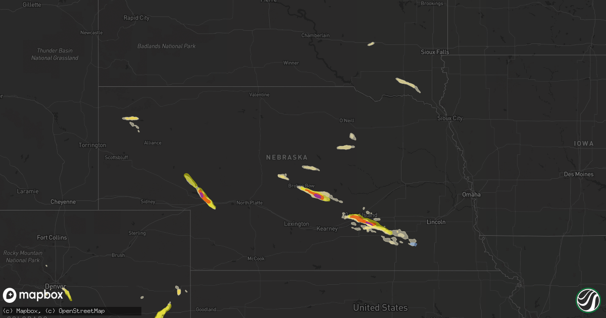
Hail Map in Nebraska on July 26, 2022
Get this storm
July 26 map
$229
one time, instant access
Download today. No call, no setup
Keep the $229
Bought the map and want the full workflow? Apply the entire $229 to a subscription within 7 days. None of it is wasted.
Every map, not just this one
This buys you this map. Subscription and you get every map we run, in the markets you choose from a few cities to whole states to nationwide. Plus real-time alerts the moment a storm fires.
Contact data
Name, contact info, occupancy, even credit band for addresses in the footprint. You go from where it hit to who to call.
Become the source they trust
Unlimited branding weather history reports on demand. You already have the documented answer ready for the property owner, and you are the one who showed up with it.
Property data and RoofTrace estimates
Pull up any address you have got, its value and the exact code rules for that jurisdiction, straight from One Click Code. Then RoofTrace estimates the squares, pitch, and roof value, priced the way you price.
Storm reports in Nebraska
Nebraska
| Date | Description |
|---|---|
| 07/26/20226:56 PM CDT | Golfball size hail reported in and just east of giltner. |
| 07/26/20226:50 PM CDT | Stones 2 inches in diameter found in town. |
| 07/26/20226:45 PM CDT | A local report indicates 1.75 inch wind near 3 W GILTNER |
| 07/26/20226:40 PM CDT | Spotter reported half dollar size hail here at 636pm... Now up to golf ball size. |
| 07/26/20226:19 PM CDT | Report from the far south side of grand island. |
| 07/26/20226:15 PM CDT | A local report indicates 1.00 inch wind near 3 SW GRAND ISLAND |
| 07/26/20226:10 PM CDT | A local report indicates 1.00 inch wind near 3 N ALDA |
| 07/26/20225:53 PM CDT | Brief touchdown was observed. |
| 07/26/20225:45 PM CDT | Blowing in excess of 60 mph |
| 07/26/20225:44 PM CDT | A local report indicates 1.00 inch wind near 2 ESE MASON CITY |
| 07/26/20225:44 PM CDT | A local report indicates 61 MPH wind near 3 WSW OGALLALA |
| 07/26/20225:44 PM CDT | A local report indicates 1.50 inch wind near 3 W ROSCOE |
| 07/26/20225:35 PM CDT | Several animal water tanks and a 32 foot stock trailer flipped on side in a field. Time estimated from radar data. |
| 07/26/20225:35 PM CDT | Some shingles blown off roof of buildings and home.time estimated from radar. |
| 07/26/20225:19 PM CDT | Damage to tree limbs and a flag pole. Time estimated by radar. |
| 07/26/20223:03 AM CDT | At 803 PM CDT, a severe thunderstorm was located 4 miles south of Exeter, or 21 miles southeast of York, moving southeast at 35 mph. HAZARD...60 mph wind gusts and quarter size hail. SOURCE...Radar indicated. IMPACT...Hail damage to vehicles is expected. Expect wind damage to roofs, siding, and trees. This severe thunderstorm will be near... Friend around 810 PM CDT.Other locations in the path of this severe thunderstorm includeWestern, Swanton, Wilber and De Witt. |
| 07/26/20222:41 AM CDT | At 740 PM CDT, a severe thunderstorm was located over Grafton, or 15 miles southwest of York, moving east at 30 mph. HAZARD...60 mph wind gusts and half dollar size hail. SOURCE...Radar indicated. IMPACT...Hail damage to vehicles is expected. Expect wind damage to roofs, siding, and trees. This severe thunderstorm will be near... Fairmont around 755 PM CDT. Geneva around 800 PM CDT.Other locations in the path of this severe thunderstorm includeExeter and Milligan. |
| 07/26/20221:59 AM CDT | At 659 PM CDT, a severe thunderstorm was located near Giltner, or 20 miles northeast of Hastings, moving east at 30 mph. HAZARD...Golf ball size hail and 60 mph wind gusts. SOURCE...Radar indicated. IMPACT...People and animals outdoors will be injured. Expect hail damage to roofs, siding, windows, and vehicles. Expect wind damage to roofs, siding, and trees. This severe thunderstorm will be near... Stockham around 710 PM CDT.Other locations in the path of this severe thunderstorm includeHenderson, Saronville, Sutton, Lushton, Grafton, Geneva and Fairmont.This includes Interstate 80 between mile markers 327 and 359. |
| 07/26/20221:58 AM CDT | At 658 PM CDT, a severe thunderstorm was located near Giltner, or 17 miles northeast of Hastings, moving east at 30 mph. HAZARD...Golf ball size hail and 60 mph wind gusts. SOURCE...Radar indicated. IMPACT...People and animals outdoors will be injured. Expect hail damage to roofs, siding, windows, and vehicles. Expect wind damage to roofs, siding, and trees. This severe thunderstorm will be near... Stockham around 715 PM CDT.Other locations in the path of this severe thunderstorm includeSaronville, Sutton, Lushton and Grafton.This includes Interstate 80 between mile markers 324 and 332. |
| 07/26/20221:21 AM CDT | At 621 PM CDT, a severe thunderstorm was located over Doniphan, or 7 miles south of Grand Island, moving east at 30 mph. HAZARD...60 mph wind gusts and quarter size hail. SOURCE...Radar indicated. IMPACT...Hail damage to vehicles is expected. Expect wind damage to roofs, siding, and trees. This severe thunderstorm will be near... Phillips around 635 PM CDT.Other locations in the path of this severe thunderstorm includeGiltner and Stockham.This includes Interstate 80 between mile markers 307 and 341. |
| 07/26/202212:57 AM CDT | At 557 PM CDT, a severe thunderstorm was located near Alda, or near Grand Island, moving east at 25 mph. HAZARD...60 mph wind gusts and half dollar size hail. SOURCE...Radar indicated. IMPACT...Hail damage to vehicles is expected. Expect wind damage to roofs, siding, and trees. This severe thunderstorm will be near... Grand Island around 615 PM CDT.Other locations in the path of this severe thunderstorm includePhillips, Chapman and Marquette. |
| 07/26/202212:32 AM CDT | At 531 PM CDT, a severe thunderstorm was located over Mason City, or 21 miles southeast of Broken Bow, moving southeast at 35 mph. HAZARD...Golf ball size hail and 60 mph wind gusts. SOURCE...Radar indicated. IMPACT...People and animals outdoors will be injured. Expect hail damage to roofs, siding, windows, and vehicles. Expect wind damage to roofs, siding, and trees. This severe thunderstorm will be near... Litchfield around 550 PM CDT.Other locations in the path of this severe thunderstorm includeHazard and Rockville. |
| 07/26/202212:26 AM CDT | At 526 PM CDT, a severe thunderstorm was located over Ansley, or 17 miles southeast of Broken Bow, moving east at 35 mph. HAZARD...60 mph wind gusts and quarter size hail. SOURCE...Radar indicated. IMPACT...Hail damage to vehicles is expected. Expect wind damage to roofs, siding, and trees. Locations impacted include... Ansley, Mason City and Gavin Siding. This includes the following highways... Highway 183 between mile markers 83 and 97. Highway 2 between mile markers 292 and 307. Highway 92 between mile markers 300 and 308. |
| 07/25/202211:55 PM CDT | At 454 PM MDT, a severe thunderstorm was located near Roscoe, or near Ogallala, moving southeast at 30 mph. HAZARD...Ping pong ball size hail and 60 mph wind gusts. SOURCE...Radar indicated. IMPACT...People and animals outdoors will be injured. Expect hail damage to roofs, siding, windows, and vehicles. Expect wind damage to roofs, siding, and trees. Locations impacted include... Madrid and Elsie. This includes Interstate 80 in Nebraska between mile markers 133 and139. |
| 07/25/202211:22 PM CDT | At 421 PM MDT, a severe thunderstorm was located over Lemoyne, or 10 miles north of Ogallala, moving southeast at 35 mph. HAZARD...60 mph wind gusts and half dollar size hail. SOURCE...Radar indicated. IMPACT...Hail damage to vehicles is expected. Expect wind damage to roofs, siding, and trees. Locations impacted include... Ogallala, Lemoyne, Keystone, Roscoe, Kingsley Dam, Wild Horse Spring, Belmar, Broganville, Otter Creek Campground and Lake View Campground.This includes the following highways... Highway 61 between mile markers 72 and 108. Highway 92 between mile markers 124 and 138. Interstate 80 in Nebraska between mile markers 118 and 144. |
| 07/25/202210:44 PM CDT | At 343 PM MDT, a severe thunderstorm was located 12 miles north of Lewellen, or 15 miles east of Oshkosh, moving southeast at 30 mph. HAZARD...60 mph wind gusts and quarter size hail. SOURCE...Radar indicated. IMPACT...Hail damage to vehicles is expected. Expect wind damage to roofs, siding, and trees. Locations impacted include... Lemoyne, Eagle Gulch Campground, Ruthon, Belmar, Clear Creek State Wildlife Management Area, Otter Creek Campground and Lake View Campground.This includes the following highways... Highway 61 between mile markers 99 and 111. Highway 92 between mile markers 117 and 138. |
| 07/25/20227:49 PM CDT | A few quarter size stones... Most were smaller. |
All States Impacted by Hail Map on July 26, 2022
Cities Impacted by Hail Map on July 26, 2022
- Hastings, NE
- Doniphan, NE
- Dover, TN
- Hampton, NE
- Aurora, NE
- Naylor, MO
- Harviell, MO
- Fairdealing, MO
- Annandale, MN
- Maple Lake, MN
- Ewing, NE
- Idalia, CO
- Spring Hill, FL
- Mocksville, NC
- Seminole, FL
- Largo, FL
- Evergreen, CO
- Indian Hills, CO
- Colorado Springs, CO
- Yoder, CO
- Mason City, NE
- Rockville, NE
- Litchfield, NE
- Ansley, NE
- Loup City, NE
- Broken Bow, NE
- Parker, CO
- Aurora, CO
- Pueblo, CO
- Denver, CO
- Flagler, CO
- Stratton, CO
- Vona, CO
- Seibert, CO
- Cope, CO
- Hemingford, NE
- Alto, NM
- Inglis, FL
- Calhan, CO
- Grand Island, NE
- Chapman, NE
- Phillips, NE
- Rector, AR
- Darwin, MN
- Litchfield, MN
- Hutchinson, MN
- Giltner, NE
- College Grove, TN
- Nolensville, TN
- Arrington, TN
- Clarksville, TN
- Marsland, NE
- Crawford, NE
- Hugo, CO
- Woodlawn, TN
- Tribune, KS
- Syracuse, KS
- Lakin, KS
- Leoti, KS
- Geneva, NE
- Ohiowa, NE
- Ulysses, KS
- Satanta, KS
- Waverly, TN
- Pocahontas, AR
- Maynard, AR
- Union City, TN
- Martin, TN
- South Fulton, TN
- Nokomis, FL
- Osprey, FL
- Venice, FL
- Vermillion, SD
- Volin, SD
- Mission Hill, SD
- Utica, SD
- Irene, SD
- Lesterville, SD
- Wakonda, SD
- Boelus, NE
- Morrison, CO
- Littleton, CO
- Mitchell, SD
- Mount Vernon, SD
- Saint Charles, MO
- Moravian Falls, NC
- Wood River, NE
- Longmont, CO
- Boulder, CO
- Rush, CO
- Arnold, NE
- Anselmo, NE
- Piggott, AR
- South Haven, MN
- Shickley, NE
- Clarkton, MO
- Indian Mound, TN
- Port Richey, FL
- New Port Richey, FL
- Hudson, FL
- Oxly, MO
- Doniphan, MO
- Success, AR
- Henderson, NE
- Grafton, NE
- Sutton, NE
- Shakopee, MN
- Jordan, MN
- Bartlett, NE
- Chambers, NE
- Burwell, NE
- Sargent, NE
- Comstock, NE
- Trenton, KY
- Ogallala, NE
- Lemoyne, NE
- Stewart, TN
- New Johnsonville, TN
- Eva, TN
- Big Sandy, TN
- Alda, NE
- Tobias, NE
- Western, NE
- Dorchester, NE
- Milligan, NE
- Folsom, NM
- Lewellen, NE
- Strang, NE
- Imboden, AR
- Exeter, NE
- Fairmont, NE
- Friend, NE
- Harvard, NE
- Inverness, FL
- Hermann, MO
- Brooksville, FL
- Trumbull, NE
- Shelton, NE
- Brule, NE
- Ord, NE
- Ravenna, NE
- Cairo, NE
- Saint Petersburg, FL
- Ordway, CO
- Kit Carson, CO
- Bethune, CO
- Karval, CO
- Portsmouth, VA
- Chesapeake, VA
- Virginia Beach, VA
- Norfolk, VA
- Arthur, NE
- Swanton, NE
- Wilber, NE


