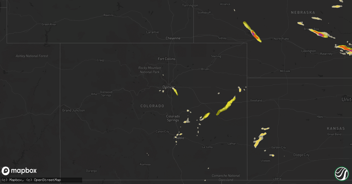
Hail Map on July 26, 2022
Get this storm
July 26 map
$229
one time, instant access
Download today. No call, no setup
Keep the $229
Bought the map and want the full workflow? Apply the entire $229 to a subscription within 7 days. None of it is wasted.
Every map, not just this one
This buys you this map. Subscription and you get every map we run, in the markets you choose from a few cities to whole states to nationwide. Plus real-time alerts the moment a storm fires.
Contact data
Name, contact info, occupancy, even credit band for addresses in the footprint. You go from where it hit to who to call.
Become the source they trust
Unlimited branding weather history reports on demand. You already have the documented answer ready for the property owner, and you are the one who showed up with it.
Property data and RoofTrace estimates
Pull up any address you have got, its value and the exact code rules for that jurisdiction, straight from One Click Code. Then RoofTrace estimates the squares, pitch, and roof value, priced the way you price.
States Impacted by Hail Map on July 26, 2022
Storm reports
Colorado
| Date | Description |
|---|---|
| 07/26/20226:30 PM CDT | 3 to 4 inch tree branches down and scattered around the area... Expanding about 1 mile from this location. |
| 07/26/20226:24 PM CDT | Report from mping: quarter |
| 07/26/20226:19 PM CDT | A local report indicates 63 MPH wind near 3 SSW ARAPAHOE PARK |
| 07/26/20226:11 PM CDT | Mesonet station beyc2 buckeye. Time estimated. |
| 07/26/20226:10 PM CDT | Nickel sized hail reported. Time and location estimated. |
| 07/26/20226:09 PM CDT | Report from a personal weather station. Also recorded up to quarter size hail. Wind-driven hail caused minor damage to windows... Siding... And a hot tub cover. The tim |
| 07/26/20226:09 PM CDT | Time and location estimated. |
| 07/26/20226:09 PM CDT | Most stones pea to half inch diameter. Time estimated. |
| 07/26/20226:06 PM CDT | Report from mping: 3-inch tree limbs broken; power poles broken. |
| 07/26/20226:04 PM CDT | Large tree limbs down. Time and location estimated. |
| 07/26/20225:50 PM CDT | Estimated time of report. |
| 07/26/20225:45 PM CDT | Delayed report via phone of half dollar hail at 4:45 |
| 07/26/20225:45 PM CDT | Tornado observed along i-70 east of siebert via colorado dot camera. Time and location estimated. |
| 07/26/20225:42 PM CDT | Public report via picture on social media of a tornado 1 mile west of seibert... Co. |
| 07/26/20225:40 PM CDT | Video showing tornado 2 miles south of vona... Co. Report via social media. Location and timing are estimated. |
| 07/26/20225:36 PM CDT | Em reported via phone rotation and flying debris west of stratton... Co. Location is estimated. |
| 07/26/20225:36 PM CDT | Tornado damage reported roughly half a mile west of vona. Damage was to a home and garage. |
| 07/26/20225:36 PM CDT | Corrects previous funnel cloud report from 1 w vona. .5 mile debris flying debris reported via phone by kit carson... Co em about to cross hwy 24. |
| 07/26/20225:32 PM CDT | Half mile west of vona producing debris. |
| 07/26/20225:20 PM CDT | Public reported a tornado via three pictures on social media. Location was estimated to be 30 miles west of burlington... Co. Location and timing are estimated. |
| 07/26/20225:13 PM CDT | Public reported a photo of a tornado via social media 2 miles northwest of stratton... Co. Location and timing are estimated. |
| 07/26/20225:12 PM CDT | Reported via social media. |
| 07/26/20225:11 PM CDT | Public report of a video showing a tornado. Video taken from a vehicle leaving stratton heading east. Location and timing are estimated. |
| 07/26/20225:10 PM CDT | Delayed public report via photo on social media of a tornado 4 miles north-northwest of stratton... Co. Timing and location are estimated. |
| 07/26/20225:10 PM CDT | Kit carson county deputies reported a tornado. |
| 07/26/20225:08 PM CDT | Trained spotter reports tornado. Location is estimated. Spotter is west of burlington looking west-northwest. |
| 07/26/20225:07 PM CDT | Tornado lasted 10 minutes. Formed at cr cc straight north of stratton. |
| 07/26/20225:07 PM CDT | Lasted roughly 10 minutes. Roughly near cr cc and cr 31. |
| 07/26/20225:07 PM CDT | Tornado lasted 10 minutes. Formed near cr cc and cr 31 north of stratton. |
| 07/26/20225:02 PM CDT | Tornado. |
| 07/26/20224:53 PM CDT | Public reported a 20-30 second duration landspout tornado between stratton and kirk... Co. Funnel was seen from the ground to close to or all the way to the cloud base. |
| 07/26/20224:51 PM CDT | Lasted for three minutes. Estimated location. |
| 07/26/20224:24 AM CDT | At 924 PM MDT, a severe thunderstorm was located near Rocky Ford, or 11 miles northwest of La Junta, moving southeast at 20 mph. HAZARD...60 mph wind gusts and penny size hail. SOURCE...Radar indicated. IMPACT...Expect damage to roofs, siding, and trees. Locations impacted include... La Junta, North La Junta, Rocky Ford, Ordway, Swink, Cheraw and Crowley. |
| 07/26/20222:05 AM CDT | At 704 PM MDT, severe thunderstorms were located along a line extending from near Rush to near Hanover. This line is nearly stationary. HAZARD...60 mph wind gusts and quarter size hail. SOURCE...Radar indicated. IMPACT...Hail damage to vehicles is expected. Expect wind damage to roofs, siding, and trees. Locations impacted include... Schriever AFB, Hanover, Truckton, Yoder, Ellicott and Rush. |
| 07/26/20221:41 AM CDT | At 641 PM MDT, a severe thunderstorm was located 10 miles northeast of Punkin Center, or 25 miles south of Limon, moving southwest at 20 mph. HAZARD...60 mph wind gusts and half dollar size hail. SOURCE...Radar indicated. IMPACT...Expect damage to roofs, siding, and trees. Hail damage to vehicles is possible. Locations impacted include... Punkin Center. |
| 07/26/202212:38 AM CDT | At 538 PM MDT, a severe thunderstorm was located 14 miles south of Seibert, moving southwest at 20 mph. HAZARD...60 mph wind gusts and quarter size hail. SOURCE...Radar indicated. IMPACT...Hail damage to vehicles is expected. Expect wind damage to roofs, siding, and trees. This severe thunderstorm will remain over mainly rural areas of northwestern Cheyenne County in east central Colorado, including the following locations... Wild Horse and Aroya. |
| 07/26/202212:29 AM CDT | At 528 PM MDT, a severe thunderstorm was located 5 miles northeast of Parker, or 19 miles southeast of Denver, moving southeast at 20 mph. HAZARD...60 mph wind gusts and quarter size hail. SOURCE...Radar indicated. IMPACT...Possible damage to roofs, siding, and trees. Hail damage to vegetation is expected. This severe thunderstorm will be near... The Pinery around 540 PM MDT.Other locations in the path of this severe thunderstorm includePonderosa Park. |
| 07/26/202212:25 AM CDT | At 525 PM MDT, a severe thunderstorm was located 8 miles southwest of Salt Creek, or 10 miles south of Pueblo, moving south at 10 mph. HAZARD...60 mph wind gusts and quarter size hail. SOURCE...Radar indicated. IMPACT...Hail damage to vehicles is expected. Expect wind damage to roofs, siding, and trees. This severe thunderstorm will remain over mainly rural areas of central Pueblo County. |
| 07/26/202212:15 AM CDT | At 514 PM MDT, a severe thunderstorm was located near Morrison, or 13 miles southwest of Denver, moving east at 15 mph. HAZARD...60 mph wind gusts and quarter size hail. SOURCE...Radar indicated. IMPACT...Expect damage to roofs, siding, and trees. Hail damage to vegetation is expected. This severe thunderstorm will be near... Southern Lakewood around 530 PM MDT.Other locations in the path of this severe thunderstorm includeChatfield Reservoir, northwestern Highlands Ranch, Littleton,Englewood and Sheridan. |
| 07/26/202212:06 AM CDT | At 506 PM MDT, a severe thunderstorm was located over Aurora, or 10 miles southeast of Denver, moving southeast at 20 mph. HAZARD...60 mph wind gusts and quarter size hail. SOURCE...Radar indicated. IMPACT...Expect damage to roofs, siding, and trees. Hail damage to vehicles is expected. This severe thunderstorm will be near... Parker and Arapahoe Park around 510 PM MDT. |
| 07/25/202211:59 PM CDT | At 458 PM MDT, a severe thunderstorm was located near Vona, or 7 miles southwest of Stratton, moving south at 15 mph. HAZARD...60 mph wind gusts and half dollar size hail. SOURCE...Radar indicated. IMPACT...Hail damage to vehicles is expected. Expect wind damage to roofs, siding, and trees. This severe thunderstorm will remain over mainly rural areas of western Kit Carson County.This includes Interstate 70 in Colorado between mile markers 406 and434. |
| 07/25/202211:54 PM CDT | At 454 PM MDT, a severe thunderstorm was located over Pueblo Reservoir, or near Pueblo, and is nearly stationary. HAZARD...60 mph wind gusts and half dollar size hail. SOURCE...Radar indicated. IMPACT...Hail damage to vehicles is expected. Expect wind damage to roofs, siding, and trees. Locations impacted include... Pueblo, Pueblo Reservoir, Salt Creek and Pueblo West. |
| 07/25/20228:47 PM CDT | 2 barn structures were destroyed. |
Tennessee
| Date | Description |
|---|---|
| 07/26/20222:52 PM CDT | Large healthy oak tree down oak hill golf course and fairways drive. Time estimated via radar. |
| 07/26/20222:30 PM CDT | Smokey barn news reports several trees and power lines down across the county with some roads blocked. |
| 07/26/20222:30 PM CDT | Corrects previous tstm wnd dmg report from 1 ssw greenbrier. Large healthy oak tree down oak hill golf course and fairways drive. Time estimated via radar. |
| 07/26/20222:24 PM CDT | Twitter report of significant damage portland high school baseball field. Dugout destroyed... Outfield fence down... And damage to indoor facility. In addition damage r |
| 07/26/20222:20 PM CDT | Corrects previous tstm wnd dmg report from springfield. Smokey barn news reports several trees and power lines down across the county with some roads blocked. |
| 07/26/20221:50 PM CDT | Trees reported down throughout the county. |
| 07/26/20221:46 PM CDT | Trees down reported in indian mound. One one red top road. Another report of a limb on a power line. Time estimated via radar. |
| 07/26/20221:42 PM CDT | Report of trees down. Time estimated via radar. |
| 07/26/20221:36 PM CDT | Report of trees down. Also numerous reports of trees down through the county. Time estimated via radar. |
| 07/26/20221:26 PM CDT | Corrects previous tstm wnd dmg report from 7 ene clarksville. Report of trees down on guthrie highway. Time estimated via radar. |
| 07/26/20221:23 PM CDT | Corrects previous tstm wnd dmg report from 2 nne clarksville. Report of trees down on needmore road. Time estimated via radar. |
| 07/26/20221:12 PM CDT | Corrects previous tstm wnd dmg report from 5 nnw clarksville. Report of trees down on tiny town road. Time estimated via radar. |
| 07/26/20221:12 PM CDT | Report of trees down. Time estimated via radara. |
| 07/26/20221:10 PM CDT | Corrects previous tstm wnd dmg report from 10 n cumberland city. Trees reported down in indian mound. One on red top road. Another report of a limb on a power line. Tim |
| 07/25/202210:35 PM CDT | At 335 PM CDT, a severe thunderstorm was located 5 miles northwest of Waverly, moving southeast at 15 mph. HAZARD...60 mph wind gusts and penny size hail. SOURCE...Radar indicated. IMPACT...Expect damage to roofs, siding, and trees. Locations impacted include... Waverly, Camden, New Johnsonville, McEwen and Hurricane Mills. This includes Interstate 40 near mile marker 147. |
| 07/25/20229:32 PM CDT | At 232 PM CDT, a severe thunderstorm was located over Springfield, moving east at 20 mph. HAZARD...60 mph wind gusts. SOURCE...Radar indicated. IMPACT...Expect damage to roofs, siding, and trees. Locations impacted include... Springfield, White House, Greenbrier, Coopertown, Cross Plains and Orlinda.This includes Interstate 65 between mile markers 108 and 112. |
| 07/25/20229:12 PM CDT | At 211 PM CDT, severe thunderstorms were located along a line extending from near Springfield to near Vanleen, moving southeast at 30 mph. HAZARD...60 mph wind gusts. SOURCE...Radar indicated. IMPACT...Expect damage to roofs, siding, and trees. Locations impacted include... Gallatin, Ashland City, Nashville, Madison, Hendersonville, Mount Juliet, Goodlettsville, White House, Millersville, Greenbrier, White Bluff, Belle Meade, Kingston Springs, Lakewood, Pegram, Ridgetop, Old Hickory, Joelton, Bells Bend and Whites Creek.This includes the following highways... Interstate 40 between mile markers 185 and 209. Interstate 65 between mile markers 85 and 107. Interstate 24 between mile markers 29 and 49. |
| 07/25/20228:47 PM CDT | At 147 PM CDT, severe thunderstorms were located along a line extending from 9 miles northwest of Coopertown to 12 miles east of Erin, moving southeast at 25 mph. HAZARD...60 mph wind gusts and penny size hail. SOURCE...Radar indicated. IMPACT...Expect damage to roofs, siding, and trees. Locations impacted include... Springfield, Clarksville, White House, Greenbrier, Coopertown, Pleasant View, Adams, Cedar Hill, Cheatham Dam, Palmyra and Cunningham.This includes the following highways... Interstate 65 between mile markers 108 and 109. Interstate 24 between mile markers 5 and 28. |
Missouri
| Date | Description |
|---|---|
| 07/26/20222:05 PM CDT | Tree was snapped in clarkton. Nearby mesonet measured 36 mph wind gust. |
| 07/26/20221:45 PM CDT | The ripley county sheriff reported trees down from thunderstorm winds about 5 miles southeast of doniphan occurring at 145 pm. |
| 07/25/20228:39 PM CDT | At 138 PM CDT, a severe thunderstorm was located near Oxly, or 7 miles southeast of Doniphan, moving south at 20 mph. HAZARD...60 mph wind gusts and quarter size hail. SOURCE...Radar indicated. IMPACT...Hail damage to vehicles is expected. Expect wind damage to roofs, siding, and trees. This severe thunderstorm will remain over mainly rural areas of southeastern Ripley County. |
South Dakota
| Date | Description |
|---|---|
| 07/26/202212:14 AM CDT | At 514 PM CDT, a severe thunderstorm was located near Mayfield, or 13 miles north of Yankton, moving east at 35 mph. HAZARD...60 mph wind gusts and quarter size hail. SOURCE...Radar indicated. IMPACT...Hail damage to vehicles is expected. Expect wind damage to roofs, siding, and trees. This severe thunderstorm will be near... Mayfield around 525 PM CDT.Other locations in the path of this severe thunderstorm includeIrene, Mission Hill, Volin, Wakonda and Meckling. |
| 07/25/202210:24 PM CDT | At 323 PM CDT, a severe thunderstorm was located near Mitchell, moving east at 30 mph. HAZARD...60 mph wind gusts and quarter size hail. SOURCE...Radar indicated. IMPACT...Hail damage to vehicles is expected. Expect wind damage to roofs, siding, and trees. Locations impacted include... Fulton, Alexandria, Farmer and Emery. |
Florida
| Date | Description |
|---|---|
| 07/26/20225:39 PM CDT | Delayed report of tree down at the intersection of w newberry rd and nw 109th dr. |
| 07/26/20225:38 PM CDT | Delayed report of tree down along 2nd st. |
| 07/26/20223:29 PM CDT | Asos station kbkv brooksville. |
| 07/26/20222:15 PM CDT | Asos station ktpa tampa. |
| 07/26/20223:58 AM CDT | At 858 PM EDT, a severe thunderstorm was located over Perry, moving northwest at 15 mph. HAZARD...60 mph wind gusts. SOURCE...Radar indicated. IMPACT...Expect damage to roofs, siding, and trees. Locations impacted include... Perry, Pinland, Iddo, Secotan, Boyd, Econfina, Lake Bird, Foley, Perry-Foley Airport, Bucell Junction, Hampton Springs, Shady Grove and Fenholloway. |
| 07/26/20221:06 AM CDT | At 606 PM EDT, a severe thunderstorm was located over Archer, or 8 miles northeast of Bronson, moving west at 15 mph. HAZARD...60 mph wind gusts. SOURCE...Radar indicated. IMPACT...Expect damage to roofs, siding, and trees. Locations impacted include... Archer. |
| 07/25/20228:00 PM CDT | A few trees and at least one power line were down in the perry area. |
Virginia
| Date | Description |
|---|---|
| 07/26/20224:26 PM CDT | Tree down on garden road. |
| 07/26/20224:14 PM CDT | Corrects previous tstm wnd dmg report from 3 sw abilene. Tree and powerline down on abilene road. |
| 07/26/20224:11 PM CDT | Tree down on tobacco hill road. |
| 07/26/20224:09 PM CDT | Tree down on winns creek rd. |
| 07/26/20224:07 PM CDT | Tree down on crystal hill road. |
| 07/26/20224:07 PM CDT | Tree down near intersection of dudley road and lp bailey memorial highway. |
| 07/26/20224:04 PM CDT | Tree down near intersection of tom fork and witcher road. |
| 07/26/20223:57 PM CDT | Tree down on lp bailey memorial highway. |
| 07/26/20223:47 PM CDT | Tree down near intersection of robin road and hawk road. |
| 07/26/20223:37 PM CDT | Tree down on west witt road. |
| 07/26/20223:34 PM CDT | Tree down near intersection of mitchell road and cox road. |
| 07/26/20223:29 PM CDT | Tree down on long island road near gladys va. |
| 07/26/20223:14 PM CDT | Tree down on chalk level road in chatam... Va. |
| 07/26/20222:58 PM CDT | Tree down and blocking the road on toddsbury road in altavista va. |
| 07/26/20222:52 PM CDT | Multiple trees knocked down across the central portion of new kent county. Time estimated from radar. |
| 07/26/20222:47 PM CDT | Tree down on deer haven drive. |
| 07/26/20222:44 PM CDT | Trees down on maryland avenue. Time estimated from radar. |
| 07/26/20222:38 PM CDT | Five helicopters on their side and roof damage near norfolk naval air station. |
| 07/26/20222:33 PM CDT | Tree reported down on a vehicle along bennetts pasture rd. Time estimated via radar. |
| 07/25/202211:25 PM CDT | At 425 PM EDT, a severe thunderstorm was located near Hat Creek, or near Brookneal, moving east at 25 mph. HAZARD...60 mph wind gusts. SOURCE...Radar indicated. IMPACT...Expect damage to roofs, siding, and trees. Locations impacted include... Brookneal... Charlotte Court House... Phenix... Red House... Drakes Branch... Madisonville... and Cullen. |
| 07/25/202210:47 PM CDT | At 346 PM EDT, a severe thunderstorm was located over Altavista, moving east at 30 mph. HAZARD...60 mph wind gusts. SOURCE...Radar indicated. IMPACT...Expect damage to roofs, siding, and trees. Locations impacted include... Altavista... Hurt... Brookneal... Red House... Rustburg... Evington... and Leesville. |
| 07/25/202210:34 PM CDT | At 334 PM EDT, a severe thunderstorm was located near Talleysville, moving southeast at 30 mph. HAZARD...60 mph wind gusts. SOURCE...Radar indicated. IMPACT...Expect damage to trees and powerlines. This severe thunderstorm will be near... Talleysville around 340 PM EDT. New Kent and Providence Forge around 350 PM EDT. Barhamsville and Holdcroft around 405 PM EDT. Toano and Norge around 415 PM EDT.Other locations impacted by this severe thunderstorm include Eltham,Chickahominy Shore, Croaker, Mountcastle, Cohoke, Lanexa, Mattaponi,Colonial Downs, Warren Mill and Cooke. |
| 07/25/202210:30 PM CDT | At 330 PM EDT, a severe thunderstorm was located over Churchland, moving east at 45 mph. HAZARD...60 mph wind gusts. SOURCE...Radar indicated. IMPACT...Expect damage to trees and powerlines. This severe thunderstorm will be near... Chesapeake and Portsmouth around 335 PM EDT. Downtown Norfolk, Old Dominion University, Downtown Portsmouth, Ghent, Norfolk NAS and Cradock around 340 PM EDT. Norfolk State University, Ocean View and Norview around 345 PM EDT. Virginia Wesleyan University, Kempsville, Regent University, Norfolk and Norfolk International around 350 PM EDT. Princess Anne around 400 PM EDT. Virginia Beach around 405 PM EDT.Other locations impacted by this severe thunderstorm include SouthNorfolk, Rudee Heights, Portlock, Princess Anne Plaza, Sigma,Sandbridge Beach, Huntersville, Oceana NAS, Macons Corner and Pungo. |
| 07/25/202210:27 PM CDT | At 327 PM EDT, a severe thunderstorm was located over Sydnorsville, moving east at 35 mph. HAZARD...60 mph wind gusts. SOURCE...Radar indicated. IMPACT...Expect damage to roofs, siding, and trees. Locations impacted include... Chatham... Gretna... Callands... Sydnorsville... Snow Creek... Dry Fork... and Mountain Valley. |
| 07/25/20229:19 PM CDT | At 219 PM EDT, a severe thunderstorm was located over Gum Spring, or near Goochland, moving east at 25 mph. HAZARD...60 mph wind gusts and penny size hail. SOURCE...Radar indicated. IMPACT...Expect damage to trees and powerlines. This severe thunderstorm will be near... Oilville around 235 PM EDT. Montpelier around 245 PM EDT. Wyndham around 250 PM EDT. Tuckahoe around 255 PM EDT.Other locations impacted by this severe thunderstorm include Orchid,Sandy Hook, Oliver, Vontay, Gum Tree, Irwin, Johnsons Springs,Goodall, Short Pump and Mabelton. |
South Carolina
| Date | Description |
|---|---|
| 07/26/20223:10 PM CDT | Trees down in spartanburg county at 2 locations. Time and location estimated from radar. |
| 07/25/202211:09 PM CDT | At 409 PM EDT, a severe thunderstorm was located near Spartanburg, moving east at 25 mph. HAZARD...60 mph wind gusts. SOURCE...Radar indicated. IMPACT...Expect damage to trees and power lines. Locations impacted include... Spartanburg, Gaffney, Boiling Springs SC, Pacolet, Cowpens, Roebuck, Pacolet Mills, USC Upstate, Croft State Park and Cedar Springs. |
| 07/25/202210:17 PM CDT | At 316 PM EDT, a severe thunderstorm was located 9 miles southeast of Forest City, or near Mooresboro, moving southeast at 20 mph. HAZARD...60 mph wind gusts and penny size hail. SOURCE...Radar indicated. IMPACT...Expect damage to trees and power lines. Locations impacted include... Shelby, Boiling Springs NC, Patterson Springs, Ellenboro, Lattimore, Mooresboro, Earl, Cliffside, Henrietta and Caroleen. |
Illinois
| Date | Description |
|---|---|
| 07/26/20226:50 AM CDT | Several trees down between norris city and omaha in southwest white county. |
| 07/26/20225:40 AM CDT | Late report. Several trees snapped. A green house was flipped and rolled. One house had hvac unit outside moved off the concrete pad a few feet. Damage located in the v |
| 07/26/20225:31 AM CDT | Trees and large limbs down. Shingle damage to a house. Time estimated. |
North Carolina
| Date | Description |
|---|---|
| 07/26/20223:18 PM CDT | Peak wind gust measured at the duck pier. |
| 07/26/20222:17 PM CDT | Multiple trees were reported down on utility company equipment causing 2k power outages near auburn... Nc. |
| 07/26/20221:56 PM CDT | Tree down along sanford st and vance street in baily nc. |
| 07/26/20221:45 PM CDT | Downed tree reported in gibsonville... Nc. |
| 07/26/20221:45 PM CDT | Trees and power lines down near the polkville fire department. |
| 07/26/20221:40 PM CDT | A tree was blown over onto a car. No report of injuries. |
| 07/26/20221:39 PM CDT | Trees reported down on powerlines on ebenezer church road near umpstead state park. |
| 07/26/20221:24 PM CDT | Major tree fell on power pole... Snapped power pole and lots of power outages. |
| 07/26/20221:21 PM CDT | Multiple trees were reported down on utility company equipment causing power outages just west of rocky mount-wilson regional airport. |
| 07/26/202212:41 PM CDT | Two trees down blocking the road. |
| 07/25/202211:34 PM CDT | At 433 PM EDT, severe thunderstorms were located along a line extending from near Straightstone to near Java to 6 miles northwest of Westover Hills, moving northeast at 20 mph. HAZARD...60 mph wind gusts. SOURCE...Radar indicated. IMPACT...Expect damage to roofs, siding, and trees. Locations impacted include... Danville... South Boston... Halifax... Turbeville... Ingram... Mt Airy... and Redoak. |
| 07/25/202211:23 PM CDT | At 423 PM EDT, severe thunderstorms were located along a line extending from 7 miles northeast of Duck Coe Pier to East Lake, moving east at 30 mph. HAZARD...60 mph wind gusts. SOURCE...Radar indicated. IMPACT...Expect damage to roofs, siding, and trees. Locations impacted include... Kill Devil Hills, Southern Shores, Manns Harbor, Nags Head, Mashoes, Manteo, East Lake, Colington, Whalebone, Duck Coe Pier, Roanoke Island Festival Park, Jockeys Ridge State Park, Wright Brothers National Monument, Nags Head Fishing Pier, Avalon Pier, Wanchese, Bodie Island Lighthouse and Outer Banks Fishing Pier. |
| 07/25/202210:46 PM CDT | At 345 PM EDT, a severe thunderstorm was located over Bailey, or 17 miles southwest of Nashville, moving east at 15 mph. HAZARD...60 mph wind gusts and quarter size hail. SOURCE...Radar indicated. IMPACT...Hail damage to vehicles is expected. Expect wind damage to roofs, siding, and trees. Locations impacted include... Rocky Mount, Wilson, Elm City, Bailey, Sharpsburg, Lucama, Middlesex, Black Creek, Sims and Buckhorn Reservoir. |
| 07/25/202210:00 PM CDT | At 259 PM EDT, severe thunderstorms were located along a line extending from near Wake Forest to 7 miles southwest of Fuquay-Varina, moving east at 35 mph. HAZARD...60 mph wind gusts and quarter size hail. SOURCE...Radar indicated. IMPACT...Hail damage to vehicles is expected. Expect wind damage to roofs, siding, and trees. Locations impacted include... Raleigh, Cary, Wake Forest, Garner, Fuquay-Varina, Clayton, Zebulon, Angier, Bunn and RDU International. |
| 07/25/20229:45 PM CDT | At 245 PM EDT, a severe thunderstorm was located near Bailey, or 19 miles northeast of Smithfield, moving east at 15 mph. HAZARD...60 mph wind gusts and quarter size hail. SOURCE...Radar indicated. IMPACT...Hail damage to vehicles is expected. Expect wind damage to roofs, siding, and trees. Locations impacted include... Nashville, Wilson, Bailey, Spring Hope, Middlesex, Sims, Buckhorn Reservoir and New Hope. |
| 07/25/20229:38 PM CDT | At 238 PM EDT, a severe thunderstorm was located 10 miles northwest of Shelby, or near Polkville, moving east at 5 mph. HAZARD...60 mph wind gusts and penny size hail. SOURCE...Radar indicated. IMPACT...Expect damage to trees and power lines. Locations impacted include... Shelby, Belwood, Lawndale, Fallston, Polkville, Lattimore, Kingstown, Ellenboro, Mooresboro and Casar. |
| 07/25/20229:36 PM CDT | At 236 PM EDT, a severe thunderstorm was located near Huntersville, moving east at 10 mph. HAZARD...60 mph wind gusts and penny size hail. SOURCE...Radar indicated. IMPACT...Expect damage to trees and power lines. Locations impacted include... Huntersville, Kannapolis, Downtown Concord, Northeast Charlotte, West Concord, Harrisburg, University City, Charlotte Motor Speedway, Coddle Creek Reservoir and Croft. |
| 07/25/20229:21 PM CDT | At 221 PM EDT, severe thunderstorms were located along a line extending from 6 miles south of Mebane to near Cary to near Sanford, moving east at 45 mph. HAZARD...60 mph wind gusts. SOURCE...Radar indicated. IMPACT...Expect damage to roofs, siding, and trees. Locations impacted include... Raleigh, Durham, Cary, Chapel Hill, Sanford, Hillsborough, Creedmoor, Pittsboro, Wake Forest and Garner. |
| 07/25/20228:26 PM CDT | At 126 PM EDT, a severe thunderstorm was located 7 miles southwest of Siler City, moving east at 30 mph. HAZARD...60 mph wind gusts and penny size hail. SOURCE...Radar indicated. IMPACT...Expect damage to roofs, siding, and trees. Locations impacted include... Pittsboro, Siler City, Goldston, Bynum, Harpers Crossroads, Hasty, Fearrington and Jordan Lake. |
Kansas
| Date | Description |
|---|---|
| 07/26/20223:18 AM CDT | At 818 PM CDT, a severe thunderstorm was located 8 miles southwest of Leoti, moving northeast at 20 mph. HAZARD...60 mph wind gusts and quarter size hail. SOURCE...Radar indicated. IMPACT...Hail damage to vehicles is expected. Expect wind damage to roofs, siding, and trees. Locations impacted include... Leoti. |
Minnesota
| Date | Description |
|---|---|
| 07/26/20222:51 AM CDT | At 750 PM CDT, a severe thunderstorm was located 6 miles north of Hutchinson, moving east at 25 mph. HAZARD...60 mph wind gusts and half dollar size hail. SOURCE...Radar indicated. IMPACT...Hail damage to vehicles is expected. Expect wind damage to roofs, siding, and trees. Locations impacted include... Silver Lake. |
| 07/25/20228:15 PM CDT | Fire dept reported two power poles down on cr-15 near golf course. Time estimated by radar. |
| 07/25/20227:15 PM CDT | Report received via office email. |
Nebraska
| Date | Description |
|---|---|
| 07/26/20226:56 PM CDT | Golfball size hail reported in and just east of giltner. |
| 07/26/20226:50 PM CDT | Stones 2 inches in diameter found in town. |
| 07/26/20226:45 PM CDT | A local report indicates 1.75 inch wind near 3 W GILTNER |
| 07/26/20226:40 PM CDT | Spotter reported half dollar size hail here at 636pm... Now up to golf ball size. |
| 07/26/20226:19 PM CDT | Report from the far south side of grand island. |
| 07/26/20226:15 PM CDT | A local report indicates 1.00 inch wind near 3 SW GRAND ISLAND |
| 07/26/20226:10 PM CDT | A local report indicates 1.00 inch wind near 3 N ALDA |
| 07/26/20225:53 PM CDT | Brief touchdown was observed. |
| 07/26/20225:45 PM CDT | Blowing in excess of 60 mph |
| 07/26/20225:44 PM CDT | A local report indicates 1.00 inch wind near 2 ESE MASON CITY |
| 07/26/20225:44 PM CDT | A local report indicates 1.50 inch wind near 3 W ROSCOE |
| 07/26/20225:44 PM CDT | A local report indicates 61 MPH wind near 3 WSW OGALLALA |
| 07/26/20225:35 PM CDT | Several animal water tanks and a 32 foot stock trailer flipped on side in a field. Time estimated from radar data. |
| 07/26/20225:35 PM CDT | Some shingles blown off roof of buildings and home.time estimated from radar. |
| 07/26/20225:19 PM CDT | Damage to tree limbs and a flag pole. Time estimated by radar. |
| 07/26/20223:03 AM CDT | At 803 PM CDT, a severe thunderstorm was located 4 miles south of Exeter, or 21 miles southeast of York, moving southeast at 35 mph. HAZARD...60 mph wind gusts and quarter size hail. SOURCE...Radar indicated. IMPACT...Hail damage to vehicles is expected. Expect wind damage to roofs, siding, and trees. This severe thunderstorm will be near... Friend around 810 PM CDT.Other locations in the path of this severe thunderstorm includeWestern, Swanton, Wilber and De Witt. |
| 07/26/20222:41 AM CDT | At 740 PM CDT, a severe thunderstorm was located over Grafton, or 15 miles southwest of York, moving east at 30 mph. HAZARD...60 mph wind gusts and half dollar size hail. SOURCE...Radar indicated. IMPACT...Hail damage to vehicles is expected. Expect wind damage to roofs, siding, and trees. This severe thunderstorm will be near... Fairmont around 755 PM CDT. Geneva around 800 PM CDT.Other locations in the path of this severe thunderstorm includeExeter and Milligan. |
| 07/26/20221:59 AM CDT | At 659 PM CDT, a severe thunderstorm was located near Giltner, or 20 miles northeast of Hastings, moving east at 30 mph. HAZARD...Golf ball size hail and 60 mph wind gusts. SOURCE...Radar indicated. IMPACT...People and animals outdoors will be injured. Expect hail damage to roofs, siding, windows, and vehicles. Expect wind damage to roofs, siding, and trees. This severe thunderstorm will be near... Stockham around 710 PM CDT.Other locations in the path of this severe thunderstorm includeHenderson, Saronville, Sutton, Lushton, Grafton, Geneva and Fairmont.This includes Interstate 80 between mile markers 327 and 359. |
| 07/26/20221:58 AM CDT | At 658 PM CDT, a severe thunderstorm was located near Giltner, or 17 miles northeast of Hastings, moving east at 30 mph. HAZARD...Golf ball size hail and 60 mph wind gusts. SOURCE...Radar indicated. IMPACT...People and animals outdoors will be injured. Expect hail damage to roofs, siding, windows, and vehicles. Expect wind damage to roofs, siding, and trees. This severe thunderstorm will be near... Stockham around 715 PM CDT.Other locations in the path of this severe thunderstorm includeSaronville, Sutton, Lushton and Grafton.This includes Interstate 80 between mile markers 324 and 332. |
| 07/26/20221:21 AM CDT | At 621 PM CDT, a severe thunderstorm was located over Doniphan, or 7 miles south of Grand Island, moving east at 30 mph. HAZARD...60 mph wind gusts and quarter size hail. SOURCE...Radar indicated. IMPACT...Hail damage to vehicles is expected. Expect wind damage to roofs, siding, and trees. This severe thunderstorm will be near... Phillips around 635 PM CDT.Other locations in the path of this severe thunderstorm includeGiltner and Stockham.This includes Interstate 80 between mile markers 307 and 341. |
| 07/26/202212:57 AM CDT | At 557 PM CDT, a severe thunderstorm was located near Alda, or near Grand Island, moving east at 25 mph. HAZARD...60 mph wind gusts and half dollar size hail. SOURCE...Radar indicated. IMPACT...Hail damage to vehicles is expected. Expect wind damage to roofs, siding, and trees. This severe thunderstorm will be near... Grand Island around 615 PM CDT.Other locations in the path of this severe thunderstorm includePhillips, Chapman and Marquette. |
| 07/26/202212:32 AM CDT | At 531 PM CDT, a severe thunderstorm was located over Mason City, or 21 miles southeast of Broken Bow, moving southeast at 35 mph. HAZARD...Golf ball size hail and 60 mph wind gusts. SOURCE...Radar indicated. IMPACT...People and animals outdoors will be injured. Expect hail damage to roofs, siding, windows, and vehicles. Expect wind damage to roofs, siding, and trees. This severe thunderstorm will be near... Litchfield around 550 PM CDT.Other locations in the path of this severe thunderstorm includeHazard and Rockville. |
| 07/26/202212:26 AM CDT | At 526 PM CDT, a severe thunderstorm was located over Ansley, or 17 miles southeast of Broken Bow, moving east at 35 mph. HAZARD...60 mph wind gusts and quarter size hail. SOURCE...Radar indicated. IMPACT...Hail damage to vehicles is expected. Expect wind damage to roofs, siding, and trees. Locations impacted include... Ansley, Mason City and Gavin Siding. This includes the following highways... Highway 183 between mile markers 83 and 97. Highway 2 between mile markers 292 and 307. Highway 92 between mile markers 300 and 308. |
| 07/25/202211:55 PM CDT | At 454 PM MDT, a severe thunderstorm was located near Roscoe, or near Ogallala, moving southeast at 30 mph. HAZARD...Ping pong ball size hail and 60 mph wind gusts. SOURCE...Radar indicated. IMPACT...People and animals outdoors will be injured. Expect hail damage to roofs, siding, windows, and vehicles. Expect wind damage to roofs, siding, and trees. Locations impacted include... Madrid and Elsie. This includes Interstate 80 in Nebraska between mile markers 133 and139. |
| 07/25/202211:22 PM CDT | At 421 PM MDT, a severe thunderstorm was located over Lemoyne, or 10 miles north of Ogallala, moving southeast at 35 mph. HAZARD...60 mph wind gusts and half dollar size hail. SOURCE...Radar indicated. IMPACT...Hail damage to vehicles is expected. Expect wind damage to roofs, siding, and trees. Locations impacted include... Ogallala, Lemoyne, Keystone, Roscoe, Kingsley Dam, Wild Horse Spring, Belmar, Broganville, Otter Creek Campground and Lake View Campground.This includes the following highways... Highway 61 between mile markers 72 and 108. Highway 92 between mile markers 124 and 138. Interstate 80 in Nebraska between mile markers 118 and 144. |
| 07/25/202210:44 PM CDT | At 343 PM MDT, a severe thunderstorm was located 12 miles north of Lewellen, or 15 miles east of Oshkosh, moving southeast at 30 mph. HAZARD...60 mph wind gusts and quarter size hail. SOURCE...Radar indicated. IMPACT...Hail damage to vehicles is expected. Expect wind damage to roofs, siding, and trees. Locations impacted include... Lemoyne, Eagle Gulch Campground, Ruthon, Belmar, Clear Creek State Wildlife Management Area, Otter Creek Campground and Lake View Campground.This includes the following highways... Highway 61 between mile markers 99 and 111. Highway 92 between mile markers 117 and 138. |
| 07/25/20227:49 PM CDT | A few quarter size stones... Most were smaller. |
Indiana
| Date | Description |
|---|---|
| 07/26/20226:39 AM CDT | Tree of unknown size and health downed. Time estimated from radar. |
Cities Impacted by Hail Map on July 26, 2022
- Hastings, NE
- Doniphan, NE
- Dover, TN
- Hampton, NE
- Aurora, NE
- Naylor, MO
- Harviell, MO
- Fairdealing, MO
- Annandale, MN
- Maple Lake, MN
- Ewing, NE
- Idalia, CO
- Spring Hill, FL
- Mocksville, NC
- Seminole, FL
- Largo, FL
- Evergreen, CO
- Indian Hills, CO
- Colorado Springs, CO
- Yoder, CO
- Mason City, NE
- Rockville, NE
- Litchfield, NE
- Ansley, NE
- Loup City, NE
- Broken Bow, NE
- Parker, CO
- Aurora, CO
- Pueblo, CO
- Denver, CO
- Flagler, CO
- Stratton, CO
- Vona, CO
- Seibert, CO
- Cope, CO
- Hemingford, NE
- Alto, NM
- Inglis, FL
- Calhan, CO
- Grand Island, NE
- Chapman, NE
- Phillips, NE
- Rector, AR
- Darwin, MN
- Litchfield, MN
- Hutchinson, MN
- Giltner, NE
- College Grove, TN
- Nolensville, TN
- Arrington, TN
- Clarksville, TN
- Marsland, NE
- Crawford, NE
- Hugo, CO
- Woodlawn, TN
- Tribune, KS
- Syracuse, KS
- Lakin, KS
- Leoti, KS
- Geneva, NE
- Ohiowa, NE
- Ulysses, KS
- Satanta, KS
- Waverly, TN
- Pocahontas, AR
- Maynard, AR
- Union City, TN
- Martin, TN
- South Fulton, TN
- Nokomis, FL
- Osprey, FL
- Venice, FL
- Vermillion, SD
- Volin, SD
- Mission Hill, SD
- Utica, SD
- Irene, SD
- Lesterville, SD
- Wakonda, SD
- Boelus, NE
- Morrison, CO
- Littleton, CO
- Mitchell, SD
- Mount Vernon, SD
- Saint Charles, MO
- Moravian Falls, NC
- Wood River, NE
- Longmont, CO
- Boulder, CO
- Rush, CO
- Arnold, NE
- Anselmo, NE
- Piggott, AR
- South Haven, MN
- Shickley, NE
- Clarkton, MO
- Indian Mound, TN
- Port Richey, FL
- New Port Richey, FL
- Hudson, FL
- Oxly, MO
- Doniphan, MO
- Success, AR
- Henderson, NE
- Grafton, NE
- Sutton, NE
- Shakopee, MN
- Jordan, MN
- Bartlett, NE
- Chambers, NE
- Burwell, NE
- Sargent, NE
- Comstock, NE
- Trenton, KY
- Ogallala, NE
- Lemoyne, NE
- Stewart, TN
- New Johnsonville, TN
- Eva, TN
- Big Sandy, TN
- Alda, NE
- Tobias, NE
- Western, NE
- Dorchester, NE
- Milligan, NE
- Folsom, NM
- Lewellen, NE
- Strang, NE
- Imboden, AR
- Exeter, NE
- Fairmont, NE
- Friend, NE
- Harvard, NE
- Inverness, FL
- Hermann, MO
- Brooksville, FL
- Trumbull, NE
- Shelton, NE
- Brule, NE
- Ord, NE
- Ravenna, NE
- Cairo, NE
- Saint Petersburg, FL
- Ordway, CO
- Kit Carson, CO
- Bethune, CO
- Karval, CO
- Portsmouth, VA
- Chesapeake, VA
- Virginia Beach, VA
- Norfolk, VA
- Arthur, NE
- Swanton, NE
- Wilber, NE