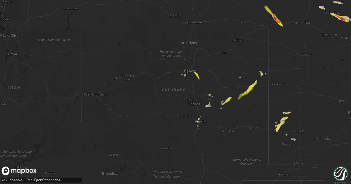
Hail Map in Colorado on July 26, 2022
Get this storm
July 26 map
$229
one time, instant access
Download today. No call, no setup
Keep the $229
Bought the map and want the full workflow? Apply the entire $229 to a subscription within 7 days. None of it is wasted.
Every map, not just this one
This buys you this map. Subscription and you get every map we run, in the markets you choose from a few cities to whole states to nationwide. Plus real-time alerts the moment a storm fires.
Contact data
Name, contact info, occupancy, even credit band for addresses in the footprint. You go from where it hit to who to call.
Become the source they trust
Unlimited branding weather history reports on demand. You already have the documented answer ready for the property owner, and you are the one who showed up with it.
Property data and RoofTrace estimates
Pull up any address you have got, its value and the exact code rules for that jurisdiction, straight from One Click Code. Then RoofTrace estimates the squares, pitch, and roof value, priced the way you price.
Storm reports in Colorado
Colorado
| Date | Description |
|---|---|
| 07/26/20226:30 PM CDT | 3 to 4 inch tree branches down and scattered around the area... Expanding about 1 mile from this location. |
| 07/26/20226:24 PM CDT | Report from mping: quarter |
| 07/26/20226:19 PM CDT | A local report indicates 63 MPH wind near 3 SSW ARAPAHOE PARK |
| 07/26/20226:11 PM CDT | Mesonet station beyc2 buckeye. Time estimated. |
| 07/26/20226:10 PM CDT | Nickel sized hail reported. Time and location estimated. |
| 07/26/20226:09 PM CDT | Report from a personal weather station. Also recorded up to quarter size hail. Wind-driven hail caused minor damage to windows... Siding... And a hot tub cover. The tim |
| 07/26/20226:09 PM CDT | Time and location estimated. |
| 07/26/20226:09 PM CDT | Most stones pea to half inch diameter. Time estimated. |
| 07/26/20226:06 PM CDT | Report from mping: 3-inch tree limbs broken; power poles broken. |
| 07/26/20226:04 PM CDT | Large tree limbs down. Time and location estimated. |
| 07/26/20225:50 PM CDT | Estimated time of report. |
| 07/26/20225:45 PM CDT | Tornado observed along i-70 east of siebert via colorado dot camera. Time and location estimated. |
| 07/26/20225:45 PM CDT | Delayed report via phone of half dollar hail at 4:45 |
| 07/26/20225:42 PM CDT | Public report via picture on social media of a tornado 1 mile west of seibert... Co. |
| 07/26/20225:40 PM CDT | Video showing tornado 2 miles south of vona... Co. Report via social media. Location and timing are estimated. |
| 07/26/20225:36 PM CDT | Tornado damage reported roughly half a mile west of vona. Damage was to a home and garage. |
| 07/26/20225:36 PM CDT | Corrects previous funnel cloud report from 1 w vona. .5 mile debris flying debris reported via phone by kit carson... Co em about to cross hwy 24. |
| 07/26/20225:36 PM CDT | Em reported via phone rotation and flying debris west of stratton... Co. Location is estimated. |
| 07/26/20225:32 PM CDT | Half mile west of vona producing debris. |
| 07/26/20225:20 PM CDT | Public reported a tornado via three pictures on social media. Location was estimated to be 30 miles west of burlington... Co. Location and timing are estimated. |
| 07/26/20225:13 PM CDT | Public reported a photo of a tornado via social media 2 miles northwest of stratton... Co. Location and timing are estimated. |
| 07/26/20225:12 PM CDT | Reported via social media. |
| 07/26/20225:11 PM CDT | Public report of a video showing a tornado. Video taken from a vehicle leaving stratton heading east. Location and timing are estimated. |
| 07/26/20225:10 PM CDT | Kit carson county deputies reported a tornado. |
| 07/26/20225:10 PM CDT | Delayed public report via photo on social media of a tornado 4 miles north-northwest of stratton... Co. Timing and location are estimated. |
| 07/26/20225:08 PM CDT | Trained spotter reports tornado. Location is estimated. Spotter is west of burlington looking west-northwest. |
| 07/26/20225:07 PM CDT | Lasted roughly 10 minutes. Roughly near cr cc and cr 31. |
| 07/26/20225:07 PM CDT | Tornado lasted 10 minutes. Formed at cr cc straight north of stratton. |
| 07/26/20225:07 PM CDT | Tornado lasted 10 minutes. Formed near cr cc and cr 31 north of stratton. |
| 07/26/20225:02 PM CDT | Tornado. |
| 07/26/20224:53 PM CDT | Public reported a 20-30 second duration landspout tornado between stratton and kirk... Co. Funnel was seen from the ground to close to or all the way to the cloud base. |
| 07/26/20224:51 PM CDT | Lasted for three minutes. Estimated location. |
| 07/26/20224:24 AM CDT | At 924 PM MDT, a severe thunderstorm was located near Rocky Ford, or 11 miles northwest of La Junta, moving southeast at 20 mph. HAZARD...60 mph wind gusts and penny size hail. SOURCE...Radar indicated. IMPACT...Expect damage to roofs, siding, and trees. Locations impacted include... La Junta, North La Junta, Rocky Ford, Ordway, Swink, Cheraw and Crowley. |
| 07/26/20222:05 AM CDT | At 704 PM MDT, severe thunderstorms were located along a line extending from near Rush to near Hanover. This line is nearly stationary. HAZARD...60 mph wind gusts and quarter size hail. SOURCE...Radar indicated. IMPACT...Hail damage to vehicles is expected. Expect wind damage to roofs, siding, and trees. Locations impacted include... Schriever AFB, Hanover, Truckton, Yoder, Ellicott and Rush. |
| 07/26/20221:41 AM CDT | At 641 PM MDT, a severe thunderstorm was located 10 miles northeast of Punkin Center, or 25 miles south of Limon, moving southwest at 20 mph. HAZARD...60 mph wind gusts and half dollar size hail. SOURCE...Radar indicated. IMPACT...Expect damage to roofs, siding, and trees. Hail damage to vehicles is possible. Locations impacted include... Punkin Center. |
| 07/26/202212:38 AM CDT | At 538 PM MDT, a severe thunderstorm was located 14 miles south of Seibert, moving southwest at 20 mph. HAZARD...60 mph wind gusts and quarter size hail. SOURCE...Radar indicated. IMPACT...Hail damage to vehicles is expected. Expect wind damage to roofs, siding, and trees. This severe thunderstorm will remain over mainly rural areas of northwestern Cheyenne County in east central Colorado, including the following locations... Wild Horse and Aroya. |
| 07/26/202212:29 AM CDT | At 528 PM MDT, a severe thunderstorm was located 5 miles northeast of Parker, or 19 miles southeast of Denver, moving southeast at 20 mph. HAZARD...60 mph wind gusts and quarter size hail. SOURCE...Radar indicated. IMPACT...Possible damage to roofs, siding, and trees. Hail damage to vegetation is expected. This severe thunderstorm will be near... The Pinery around 540 PM MDT.Other locations in the path of this severe thunderstorm includePonderosa Park. |
| 07/26/202212:25 AM CDT | At 525 PM MDT, a severe thunderstorm was located 8 miles southwest of Salt Creek, or 10 miles south of Pueblo, moving south at 10 mph. HAZARD...60 mph wind gusts and quarter size hail. SOURCE...Radar indicated. IMPACT...Hail damage to vehicles is expected. Expect wind damage to roofs, siding, and trees. This severe thunderstorm will remain over mainly rural areas of central Pueblo County. |
| 07/26/202212:15 AM CDT | At 514 PM MDT, a severe thunderstorm was located near Morrison, or 13 miles southwest of Denver, moving east at 15 mph. HAZARD...60 mph wind gusts and quarter size hail. SOURCE...Radar indicated. IMPACT...Expect damage to roofs, siding, and trees. Hail damage to vegetation is expected. This severe thunderstorm will be near... Southern Lakewood around 530 PM MDT.Other locations in the path of this severe thunderstorm includeChatfield Reservoir, northwestern Highlands Ranch, Littleton,Englewood and Sheridan. |
| 07/26/202212:06 AM CDT | At 506 PM MDT, a severe thunderstorm was located over Aurora, or 10 miles southeast of Denver, moving southeast at 20 mph. HAZARD...60 mph wind gusts and quarter size hail. SOURCE...Radar indicated. IMPACT...Expect damage to roofs, siding, and trees. Hail damage to vehicles is expected. This severe thunderstorm will be near... Parker and Arapahoe Park around 510 PM MDT. |
| 07/25/202211:59 PM CDT | At 458 PM MDT, a severe thunderstorm was located near Vona, or 7 miles southwest of Stratton, moving south at 15 mph. HAZARD...60 mph wind gusts and half dollar size hail. SOURCE...Radar indicated. IMPACT...Hail damage to vehicles is expected. Expect wind damage to roofs, siding, and trees. This severe thunderstorm will remain over mainly rural areas of western Kit Carson County.This includes Interstate 70 in Colorado between mile markers 406 and434. |
| 07/25/202211:54 PM CDT | At 454 PM MDT, a severe thunderstorm was located over Pueblo Reservoir, or near Pueblo, and is nearly stationary. HAZARD...60 mph wind gusts and half dollar size hail. SOURCE...Radar indicated. IMPACT...Hail damage to vehicles is expected. Expect wind damage to roofs, siding, and trees. Locations impacted include... Pueblo, Pueblo Reservoir, Salt Creek and Pueblo West. |
| 07/25/20228:47 PM CDT | 2 barn structures were destroyed. |
All States Impacted by Hail Map on July 26, 2022
Cities Impacted by Hail Map on July 26, 2022
- Hastings, NE
- Doniphan, NE
- Dover, TN
- Hampton, NE
- Aurora, NE
- Naylor, MO
- Harviell, MO
- Fairdealing, MO
- Annandale, MN
- Maple Lake, MN
- Ewing, NE
- Idalia, CO
- Spring Hill, FL
- Mocksville, NC
- Seminole, FL
- Largo, FL
- Evergreen, CO
- Indian Hills, CO
- Colorado Springs, CO
- Yoder, CO
- Mason City, NE
- Rockville, NE
- Litchfield, NE
- Ansley, NE
- Loup City, NE
- Broken Bow, NE
- Parker, CO
- Aurora, CO
- Pueblo, CO
- Denver, CO
- Flagler, CO
- Stratton, CO
- Vona, CO
- Seibert, CO
- Cope, CO
- Hemingford, NE
- Alto, NM
- Inglis, FL
- Calhan, CO
- Grand Island, NE
- Chapman, NE
- Phillips, NE
- Rector, AR
- Darwin, MN
- Litchfield, MN
- Hutchinson, MN
- Giltner, NE
- College Grove, TN
- Nolensville, TN
- Arrington, TN
- Clarksville, TN
- Marsland, NE
- Crawford, NE
- Hugo, CO
- Woodlawn, TN
- Tribune, KS
- Syracuse, KS
- Lakin, KS
- Leoti, KS
- Geneva, NE
- Ohiowa, NE
- Ulysses, KS
- Satanta, KS
- Waverly, TN
- Pocahontas, AR
- Maynard, AR
- Union City, TN
- Martin, TN
- South Fulton, TN
- Nokomis, FL
- Osprey, FL
- Venice, FL
- Vermillion, SD
- Volin, SD
- Mission Hill, SD
- Utica, SD
- Irene, SD
- Lesterville, SD
- Wakonda, SD
- Boelus, NE
- Morrison, CO
- Littleton, CO
- Mitchell, SD
- Mount Vernon, SD
- Saint Charles, MO
- Moravian Falls, NC
- Wood River, NE
- Longmont, CO
- Boulder, CO
- Rush, CO
- Arnold, NE
- Anselmo, NE
- Piggott, AR
- South Haven, MN
- Shickley, NE
- Clarkton, MO
- Indian Mound, TN
- Port Richey, FL
- New Port Richey, FL
- Hudson, FL
- Oxly, MO
- Doniphan, MO
- Success, AR
- Henderson, NE
- Grafton, NE
- Sutton, NE
- Shakopee, MN
- Jordan, MN
- Bartlett, NE
- Chambers, NE
- Burwell, NE
- Sargent, NE
- Comstock, NE
- Trenton, KY
- Ogallala, NE
- Lemoyne, NE
- Stewart, TN
- New Johnsonville, TN
- Eva, TN
- Big Sandy, TN
- Alda, NE
- Tobias, NE
- Western, NE
- Dorchester, NE
- Milligan, NE
- Folsom, NM
- Lewellen, NE
- Strang, NE
- Imboden, AR
- Exeter, NE
- Fairmont, NE
- Friend, NE
- Harvard, NE
- Inverness, FL
- Hermann, MO
- Brooksville, FL
- Trumbull, NE
- Shelton, NE
- Brule, NE
- Ord, NE
- Ravenna, NE
- Cairo, NE
- Saint Petersburg, FL
- Ordway, CO
- Kit Carson, CO
- Bethune, CO
- Karval, CO
- Portsmouth, VA
- Chesapeake, VA
- Virginia Beach, VA
- Norfolk, VA
- Arthur, NE
- Swanton, NE
- Wilber, NE


