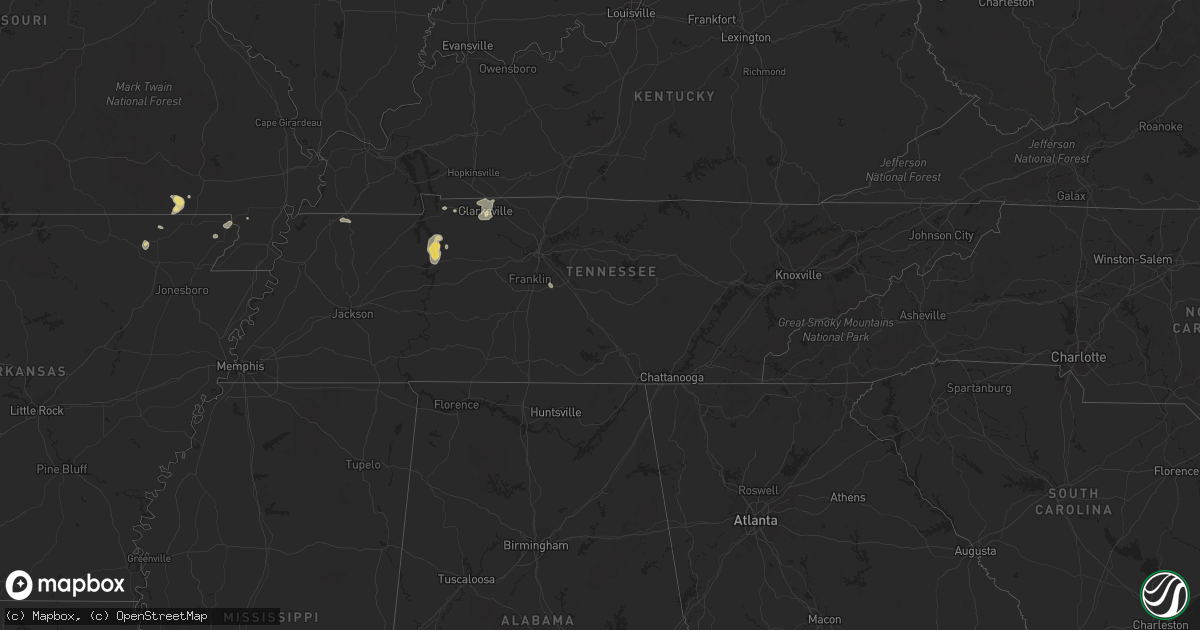
Hail Map in Tennessee on July 26, 2022
Get this storm
July 26 map
$229
one time, instant access
Download today. No call, no setup
Keep the $229
Bought the map and want the full workflow? Apply the entire $229 to a subscription within 7 days. None of it is wasted.
Every map, not just this one
This buys you this map. Subscription and you get every map we run, in the markets you choose from a few cities to whole states to nationwide. Plus real-time alerts the moment a storm fires.
Contact data
Name, contact info, occupancy, even credit band for addresses in the footprint. You go from where it hit to who to call.
Become the source they trust
Unlimited branding weather history reports on demand. You already have the documented answer ready for the property owner, and you are the one who showed up with it.
Property data and RoofTrace estimates
Pull up any address you have got, its value and the exact code rules for that jurisdiction, straight from One Click Code. Then RoofTrace estimates the squares, pitch, and roof value, priced the way you price.
Storm reports in Tennessee
Tennessee
| Date | Description |
|---|---|
| 07/26/20222:52 PM CDT | Large healthy oak tree down oak hill golf course and fairways drive. Time estimated via radar. |
| 07/26/20222:30 PM CDT | Corrects previous tstm wnd dmg report from 1 ssw greenbrier. Large healthy oak tree down oak hill golf course and fairways drive. Time estimated via radar. |
| 07/26/20222:30 PM CDT | Smokey barn news reports several trees and power lines down across the county with some roads blocked. |
| 07/26/20222:24 PM CDT | Twitter report of significant damage portland high school baseball field. Dugout destroyed... Outfield fence down... And damage to indoor facility. In addition damage r |
| 07/26/20222:20 PM CDT | Corrects previous tstm wnd dmg report from springfield. Smokey barn news reports several trees and power lines down across the county with some roads blocked. |
| 07/26/20221:50 PM CDT | Trees reported down throughout the county. |
| 07/26/20221:46 PM CDT | Trees down reported in indian mound. One one red top road. Another report of a limb on a power line. Time estimated via radar. |
| 07/26/20221:42 PM CDT | Report of trees down. Time estimated via radar. |
| 07/26/20221:36 PM CDT | Report of trees down. Also numerous reports of trees down through the county. Time estimated via radar. |
| 07/26/20221:26 PM CDT | Corrects previous tstm wnd dmg report from 7 ene clarksville. Report of trees down on guthrie highway. Time estimated via radar. |
| 07/26/20221:23 PM CDT | Corrects previous tstm wnd dmg report from 2 nne clarksville. Report of trees down on needmore road. Time estimated via radar. |
| 07/26/20221:12 PM CDT | Corrects previous tstm wnd dmg report from 5 nnw clarksville. Report of trees down on tiny town road. Time estimated via radar. |
| 07/26/20221:12 PM CDT | Report of trees down. Time estimated via radara. |
| 07/26/20221:10 PM CDT | Corrects previous tstm wnd dmg report from 10 n cumberland city. Trees reported down in indian mound. One on red top road. Another report of a limb on a power line. Tim |
| 07/25/202210:35 PM CDT | At 335 PM CDT, a severe thunderstorm was located 5 miles northwest of Waverly, moving southeast at 15 mph. HAZARD...60 mph wind gusts and penny size hail. SOURCE...Radar indicated. IMPACT...Expect damage to roofs, siding, and trees. Locations impacted include... Waverly, Camden, New Johnsonville, McEwen and Hurricane Mills. This includes Interstate 40 near mile marker 147. |
| 07/25/20229:32 PM CDT | At 232 PM CDT, a severe thunderstorm was located over Springfield, moving east at 20 mph. HAZARD...60 mph wind gusts. SOURCE...Radar indicated. IMPACT...Expect damage to roofs, siding, and trees. Locations impacted include... Springfield, White House, Greenbrier, Coopertown, Cross Plains and Orlinda.This includes Interstate 65 between mile markers 108 and 112. |
| 07/25/20229:12 PM CDT | At 211 PM CDT, severe thunderstorms were located along a line extending from near Springfield to near Vanleen, moving southeast at 30 mph. HAZARD...60 mph wind gusts. SOURCE...Radar indicated. IMPACT...Expect damage to roofs, siding, and trees. Locations impacted include... Gallatin, Ashland City, Nashville, Madison, Hendersonville, Mount Juliet, Goodlettsville, White House, Millersville, Greenbrier, White Bluff, Belle Meade, Kingston Springs, Lakewood, Pegram, Ridgetop, Old Hickory, Joelton, Bells Bend and Whites Creek.This includes the following highways... Interstate 40 between mile markers 185 and 209. Interstate 65 between mile markers 85 and 107. Interstate 24 between mile markers 29 and 49. |
| 07/25/20228:47 PM CDT | At 147 PM CDT, severe thunderstorms were located along a line extending from 9 miles northwest of Coopertown to 12 miles east of Erin, moving southeast at 25 mph. HAZARD...60 mph wind gusts and penny size hail. SOURCE...Radar indicated. IMPACT...Expect damage to roofs, siding, and trees. Locations impacted include... Springfield, Clarksville, White House, Greenbrier, Coopertown, Pleasant View, Adams, Cedar Hill, Cheatham Dam, Palmyra and Cunningham.This includes the following highways... Interstate 65 between mile markers 108 and 109. Interstate 24 between mile markers 5 and 28. |
All States Impacted by Hail Map on July 26, 2022
Cities Impacted by Hail Map on July 26, 2022
- Hastings, NE
- Doniphan, NE
- Dover, TN
- Hampton, NE
- Aurora, NE
- Naylor, MO
- Harviell, MO
- Fairdealing, MO
- Annandale, MN
- Maple Lake, MN
- Ewing, NE
- Idalia, CO
- Spring Hill, FL
- Mocksville, NC
- Seminole, FL
- Largo, FL
- Evergreen, CO
- Indian Hills, CO
- Colorado Springs, CO
- Yoder, CO
- Mason City, NE
- Rockville, NE
- Litchfield, NE
- Ansley, NE
- Loup City, NE
- Broken Bow, NE
- Parker, CO
- Aurora, CO
- Pueblo, CO
- Denver, CO
- Flagler, CO
- Stratton, CO
- Vona, CO
- Seibert, CO
- Cope, CO
- Hemingford, NE
- Alto, NM
- Inglis, FL
- Calhan, CO
- Grand Island, NE
- Chapman, NE
- Phillips, NE
- Rector, AR
- Darwin, MN
- Litchfield, MN
- Hutchinson, MN
- Giltner, NE
- College Grove, TN
- Nolensville, TN
- Arrington, TN
- Clarksville, TN
- Marsland, NE
- Crawford, NE
- Hugo, CO
- Woodlawn, TN
- Tribune, KS
- Syracuse, KS
- Lakin, KS
- Leoti, KS
- Geneva, NE
- Ohiowa, NE
- Ulysses, KS
- Satanta, KS
- Waverly, TN
- Pocahontas, AR
- Maynard, AR
- Union City, TN
- Martin, TN
- South Fulton, TN
- Nokomis, FL
- Osprey, FL
- Venice, FL
- Vermillion, SD
- Volin, SD
- Mission Hill, SD
- Utica, SD
- Irene, SD
- Lesterville, SD
- Wakonda, SD
- Boelus, NE
- Morrison, CO
- Littleton, CO
- Mitchell, SD
- Mount Vernon, SD
- Saint Charles, MO
- Moravian Falls, NC
- Wood River, NE
- Longmont, CO
- Boulder, CO
- Rush, CO
- Arnold, NE
- Anselmo, NE
- Piggott, AR
- South Haven, MN
- Shickley, NE
- Clarkton, MO
- Indian Mound, TN
- Port Richey, FL
- New Port Richey, FL
- Hudson, FL
- Oxly, MO
- Doniphan, MO
- Success, AR
- Henderson, NE
- Grafton, NE
- Sutton, NE
- Shakopee, MN
- Jordan, MN
- Bartlett, NE
- Chambers, NE
- Burwell, NE
- Sargent, NE
- Comstock, NE
- Trenton, KY
- Ogallala, NE
- Lemoyne, NE
- Stewart, TN
- New Johnsonville, TN
- Eva, TN
- Big Sandy, TN
- Alda, NE
- Tobias, NE
- Western, NE
- Dorchester, NE
- Milligan, NE
- Folsom, NM
- Lewellen, NE
- Strang, NE
- Imboden, AR
- Exeter, NE
- Fairmont, NE
- Friend, NE
- Harvard, NE
- Inverness, FL
- Hermann, MO
- Brooksville, FL
- Trumbull, NE
- Shelton, NE
- Brule, NE
- Ord, NE
- Ravenna, NE
- Cairo, NE
- Saint Petersburg, FL
- Ordway, CO
- Kit Carson, CO
- Bethune, CO
- Karval, CO
- Portsmouth, VA
- Chesapeake, VA
- Virginia Beach, VA
- Norfolk, VA
- Arthur, NE
- Swanton, NE
- Wilber, NE


