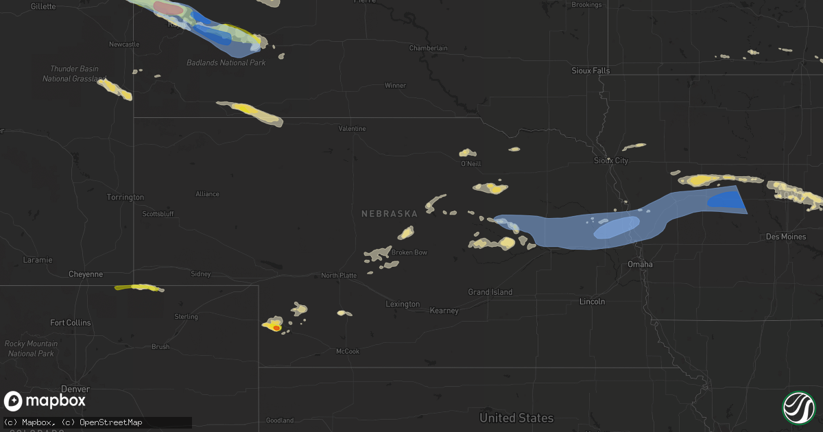
Hail Map in Nebraska on July 10, 2022
Get this storm
July 10 map
$229
one time, instant access
Download today. No call, no setup
Keep the $229
Bought the map and want the full workflow? Apply the entire $229 to a subscription within 7 days. None of it is wasted.
Every map, not just this one
This buys you this map. Subscription and you get every map we run, in the markets you choose from a few cities to whole states to nationwide. Plus real-time alerts the moment a storm fires.
Contact data
Name, contact info, occupancy, even credit band for addresses in the footprint. You go from where it hit to who to call.
Become the source they trust
Unlimited branding weather history reports on demand. You already have the documented answer ready for the property owner, and you are the one who showed up with it.
Property data and RoofTrace estimates
Pull up any address you have got, its value and the exact code rules for that jurisdiction, straight from One Click Code. Then RoofTrace estimates the squares, pitch, and roof value, priced the way you price.
Storm reports in Nebraska
Nebraska
| Date | Description |
|---|---|
| 07/10/20226:28 AM CDT | At 1127 PM CDT, a severe thunderstorm was located 4 miles west of Clearwater, or 12 miles west of Neligh, moving southeast at 20 mph. HAZARD...60 mph wind gusts and quarter size hail. SOURCE...Radar indicated. IMPACT...Hail damage to vehicles is expected. Expect wind damage to roofs, siding, and trees. This severe thunderstorm will be near... Clearwater around 1135 PM CDT.Other locations in the path of this severe thunderstorm includeNeligh. |
| 07/10/20225:44 AM CDT | At 1043 PM CDT, severe thunderstorms were located along a line extending from 7 miles southwest of Merna to near Callaway to 11 miles west of Oconto, moving east at 35 mph. HAZARD...60 mph wind gusts. SOURCE...Radar indicated. IMPACT...Expect damage to roofs, siding, and trees. Locations impacted include... Broken Bow, Callaway, Ansley, Mason City, Oconto, Berwyn, Westerville, Buckeye, Pressey State Wildlife Management Area, Burr Oak, Lodi and Cumro.This includes the following highways... Highway 183 between mile markers 77 and 98. Highway 2 between mile markers 275 and 301. Highway 92 between mile markers 300 and 303. |
| 07/10/20225:15 AM CDT | A few small branches broken. Winds associated with heat burst. |
| 07/10/20225:13 AM CDT | At 1013 PM CDT, severe thunderstorms were located along a line extending from near Arnold to 14 miles west of Callaway to 14 miles north of Brady, moving east at 25 mph. HAZARD...60 mph wind gusts. SOURCE...Radar indicated. IMPACT...Expect damage to roofs, siding, and trees. Locations impacted include... Arnold, Callaway, Finchville, Lodi and Milldale. This includes Highway 92 between mile markers 245 and 255. |
| 07/10/20224:32 AM CDT | Heat burst from decaying thunderstorms produced this severe wind gust. |
| 07/10/20224:30 AM CDT | At 930 PM CDT, a severe thunderstorm was located near Wallace, or 22 miles southwest of North Platte, moving east at 10 mph. HAZARD...60 mph wind gusts. SOURCE...Radar indicated. IMPACT...Expect damage to roofs, siding, and trees. This severe thunderstorm will remain over mainly rural areas of southwestern Lincoln County. |
| 07/10/20222:45 AM CDT | Updates previous tstm wnd gst report from 2 ese tekamah. |
| 07/10/20222:41 AM CDT | Updates previous tstm wnd gst report from 2 ese tekamah. |
| 07/10/20222:38 AM CDT | At 737 PM MDT, a severe thunderstorm was located 11 miles northeast of Imperial, moving northeast at 20 mph. HAZARD...60 mph wind gusts. SOURCE...Radar indicated. IMPACT...Expect damage to roofs, siding, and trees. Locations impacted include... Imperial, Wanamaker State Wildfire Management Area and Grainton. This includes Highway 61 between mile markers 41 and 63. |
| 07/10/20222:33 AM CDT | A local report indicates 58 MPH wind near 2 ESE TEKAMAH |
| 07/10/20222:15 AM CDT | A local report indicates 71 MPH wind near WEST POINT |
| 07/10/20222:04 AM CDT | Imperial airport |
| 07/10/20221:42 AM CDT | At 642 PM MDT, a severe thunderstorm was located near Champion, or 7 miles west of Imperial, moving east at 20 mph. HAZARD...60 mph wind gusts and quarter size hail. SOURCE...Radar indicated. IMPACT...Hail damage to vehicles is expected. Expect wind damage to roofs, siding, and trees. Locations impacted include... Imperial, Champion, Chase and Wanamaker State Wildfire Management Area.This includes Highway 61 between mile markers 41 and 49. |
| 07/10/20221:30 AM CDT | A local report indicates 68 MPH wind near CRESTON |
| 07/10/20221:29 AM CDT | A local report indicates 64 MPH wind near 3 E HUMPHREY |
| 07/10/20221:10 AM CDT | Emergency manager relayed report from lindsay of numerous trees downed and broken branches across the city. |
| 07/10/20221:10 AM CDT | Structural damage to walls and roof of a cattle shed. |
| 07/10/202212:50 AM CDT | A local report indicates 60 MPH wind near 4 NW ALBION |
| 07/09/202211:59 PM CDT | A local report indicates 58 MPH wind near ORD AIRPORT |
| 07/09/202211:59 PM CDT | Thunderstorm wind gusts... Estimated at 60-70 mph... Broke two 30 inch diameter trees. |
| 07/09/202211:45 PM CDT | Damage in town to shingles... Trees and power lines from thunderstorm outflow winds. |
| 07/09/202211:37 PM CDT | Damage in town to shingles... Trees and power lines from southerly thunderstorm outflow winds. |
| 07/09/202210:10 PM CDT | At 310 PM MDT, a severe thunderstorm was located near Panorama Point, or 21 miles southwest of Kimball, moving east at 30 mph. HAZARD...60 mph wind gusts and quarter size hail. SOURCE...Radar indicated. IMPACT...Hail damage to vehicles is expected. Expect wind damage to roofs, siding, and trees. Locations impacted include... Panorama Point. |
| 07/09/20228:05 PM CDT | Estimated time based on radar. |
| 07/09/20227:54 PM CDT | A local report indicates 1.25 inch wind near CHAMPION |
| 07/09/20227:50 PM CDT | Estimated time from radar. |
| 07/09/20227:50 PM CDT | Estimated time based on radar. 60 mph winds shredded leaves and blew walnuts off trees. |
| 07/09/20227:49 PM CDT | Relayed report from co-op observer of golf ball size hail. |
| 07/09/20227:49 PM CDT | A local report indicates 1.00 inch wind near 2 W CHAMPION |
All States Impacted by Hail Map on July 10, 2022
Cities Impacted by Hail Map on July 10, 2022
- Padroni, CO
- Champion, NE
- Argyle, MN
- Stephen, MN
- Ayr, ND
- Buffalo, ND
- Hawley, MN
- Pelican Rapids, MN
- Detroit Lakes, MN
- Glyndon, MN
- Vergas, MN
- New York Mills, MN
- Barnesville, MN
- Perham, MN
- Audubon, MN
- Menahga, MN
- Lake Park, MN
- Sebeka, MN
- Frazee, MN
- Ponsford, MN
- Clearwater, NE
- Orchard, NE
- Valley City, ND
- Gordon, WI
- Solon Springs, WI
- Iowa, LA
- Backus, MN
- Dilworth, MN
- Moorhead, MN
- Woodville, TX
- Colfax, ND
- Barney, ND
- Hunter, ND
- Erie, ND
- Columbus Junction, IA
- Conesville, IA
- Wyola, MT
- Burwell, NE
- Moose Lake, MN
- Sturgeon Lake, MN
- Winnebago, MN
- Andover, MN
- Forest Lake, MN
- Circle Pines, MN
- Ewing, NE
- Pine River, MN
- Crosslake, MN
- Pequot Lakes, MN
- Singer, LA
- Odebolt, IA
- Ida Grove, IA
- Arthur, IA
- What Cheer, IA
- Greensburg, LA
- Grover, CO
- New Raymer, CO
- Bushnell, NE
- Neligh, NE
- Holyoke, CO
- Lance Creek, WY
- Sundance, WY
- Alva, WY
- Hulett, WY
- Lodge Grass, MT
- Bridger, MT
- Harcourt, IA
- Dayton, IA
- Ainsworth, IA
- Imperial, NE
- Piedmont, SD
- Collins, IA
- White Owl, SD
- Howes, SD
- Adams, MN
- Medina, TX
- Haxtun, CO
- Boerne, TX
- Devils Lake, ND
- Crary, ND
- Deridder, LA
- Broken Bow, NE
- Anselmo, NE
- Story City, IA
- Wells, MN
- Hartland, MN
- Aitkin, MN
- Bartlett, NE
- Zachary, LA
- Petersburg, NE
- Spalding, NE
- Albion, NE
- Merriman, NE
- Martin, SD
- Wounded Knee, SD
- Batesland, SD
- Manderson, SD
- Pine Ridge, SD
- Pitkin, LA
- Owanka, SD
- New Underwood, SD
- Puposky, MN
- Black River Falls, WI
- Merrillan, WI
- Stewart, MN
- Malcom, IA
- Montezuma, IA
- Kerrick, MN
- Kingsley, IA
- Le Mars, IA
- Merrill, IA
- Hinton, IA
- Remsen, IA
- Verdigre, NE
- Center, NE
- Winnetoon, NE
- Monroe, NE
- Platte Center, NE
- Genoa, NE
- Atkinson, NE
- Oneill, NE
- Kathryn, ND
- Spiritwood, ND
- Fingal, ND
- Ypsilanti, ND
- Sheldon, ND
- Enderlin, ND
- Sanborn, ND
- Wyndmere, ND
- Litchville, ND
- Marion, ND
- Nome, ND
- Mcleod, ND
- Leonard, ND
- Yarmouth, IA
- Mount Union, IA
- Delavan, MN
- Sugartown, LA
- Mittie, LA
- Ragley, LA
- Oakdale, LA
- Grant, LA
- Dry Creek, LA
- Longville, LA
- Newcastle, WY
- Crosby, MN
- Deweyville, TX
- Call, TX
- Onawa, IA
- Moorhead, IA
- Hammond, MT
- Broadus, MT
- Alzada, MT
- New Roads, LA
- Somerset, WI
- Stillwater, MN
- Silsbee, TX
- Kountze, TX
- Belgrade, NE
- Cedar Rapids, NE
- Saint Edward, NE
- Fullerton, NE
- Baytown, TX
- Belle Fourche, SD
- Franklinton, LA
- Quinn, SD
- Wall, SD
- Tower City, ND
- Wasta, SD
- Crosby, TX
- Georgetown, MN
- Gardner, ND
- Harwood, ND
- Fargo, ND
- Felton, MN
- Argusville, ND
- Sherburn, MN
- Vale, SD
- Newell, SD
- Union Center, SD
- Sturgis, SD
- Rapid City, SD
- Box Elder, SD
- Kadoka, SD
- Caputa, SD
- Nunn, CO
- Claxton, GA
- Oriska, ND
- Page, ND
- Clearmont, WY
- Slaughter, LA
- Ethel, LA
- Saint Xavier, MT
- Port Allen, LA
- Enders, NE
- Sherwood, ND
- Akeley, MN
- Bemidji, MN
- Ventress, LA
- Durand, WI
- Mondovi, WI
- Willow River, MN
- West Point, NE
- Watkins, IA
- Blairstown, IA
- Ogema, MN
- Metter, GA
- Buna, TX
- Arnaudville, LA
- Davenport, ND
- Mapleton, ND
- Hammond, WI
- Houlton, WI
- Marine On Saint Croix, MN
- New Richmond, WI
- Holyoke, MN
- Keswick, IA
- Sigourney, IA
- Webster, IA
- Harper, IA
- Tenstrike, MN
- Busby, MT
- Garryowen, MT
- Callaway, NE
- Starks, LA
- Rochert, MN
- Callaway, MN
- Petersburg, ND
- Grand Marais, MN
- Hines, MN
- Greeley, NE
- Scotia, NE
- Wolbach, NE
- Grafton, ND
- Osage, MN
- Park Rapids, MN
- Erwinville, LA
- Jarreau, LA
- Lakeland, LA
- Nichols, IA
- Lone Tree, IA
- Horace, ND
- Wheatland, ND
- Chelsea, IA
- Elberon, IA
- Wauneta, NE
- Craig, NE
- Oakland, NE
- Philip, SD
- Milesville, SD
- Custer, SD
- Hot Springs, SD
- Edgemont, SD
- Amite, LA
- Winfield, IA
- Crawfordsville, IA
- Washington, IA
- Olds, IA
- Mount Pleasant, IA
- Wayland, IA
- Brighton, IA
- Wapello, IA
- Morning Sun, IA
- Austin, TX
- Paoli, CO
- Amherst, CO
- Sour Lake, TX
- Elsie, NE
- Hayes Center, NE
- Madrid, NE
- Marengo, IA
- Tylertown, MS
- Boone, IA
- Ames, IA
- Gilman, IA
- Hartwick, IA
- Montour, IA
- Deep River, IA
- Parnell, IA
- Brooklyn, IA
- Tama, IA
- Wellman, IA
- North English, IA
- Guernsey, IA
- Ladora, IA
- Williamsburg, IA
- Belle Plaine, IA
- South English, IA
- Kalona, IA
- Grinnell, IA
- Victor, IA
- Fordville, ND
- West Fargo, ND
- Birney, MT
- Amana, IA
- Norway, IA
- Keota, IA
- Forest Hill, LA
- Spring, TX
- Houston, TX
- Breaux Bridge, LA
- Gothenburg, NE
- Brady, NE
- Dent, MN
- Henderson, MN
- Green Isle, MN
- Ellsworth Afb, SD
- Rothsay, MN
- Wolverton, MN
- Neillsville, WI
- Deerwood, MN
- Nisland, SD
- Spearfish, SD
- Lead, SD
- Moorcroft, WY
- Deadwood, SD
- Whitewood, SD
- Devils Tower, WY
- Weston, WY
- Aladdin, WY
- Beulah, WY
- Black Hawk, SD
- Nemo, SD
- Decatur, NE
- Tekamah, NE
- Stapleton, NE
- Arnold, NE
- Merna, NE
- Casselton, ND
- Nevis, MN
- Armstrong Creek, WI
- Argonne, WI
- Conrad, IA
- Staples, MN
- Verndale, MN
- Rose Creek, MN
- West Chester, IA
- Fairmont, MN
- Welcome, MN
- Lake City, IA
- Lake View, IA
- Gowrie, IA
- Stratford, IA
- Auburn, IA
- Breda, IA
- Rockwell City, IA
- Kiron, IA
- Farnhamville, IA
- Carroll, IA
- Wall Lake, IA
- Lohrville, IA
- Borup, MN
- Boyes, MT
- Batchelor, LA
- Morganza, LA
- Strum, WI
- Whitehall, WI
- Eleva, WI
- Independence, WI
- Osseo, WI
- Bon Wier, TX
- Sioux City, IA
- Ironton, MN
- Otter, MT
- Merryville, LA
- Granada, MN
- Rose Hill, IA
- Delta, IA
- Vanderpool, TX
- Colo, IA
- Zearing, IA
- Jewell, IA
- Melbourne, IA
- Rhodes, IA
- Marshalltown, IA
- Stanhope, IA
- McCallsburg, IA
- State Center, IA
- Roland, IA
- Saint Anthony, IA
- Clemons, IA
- Nevada, IA
- Riceville, IA
- McIntire, IA
- Lumberton, TX
- International Falls, MN
- Sterling, CO
- Newman Grove, NE
- Maywood, NE
- Jackson, LA
- Saint Francisville, LA
- Lyle, MN
- White River, SD
- Long Valley, SD
- Wanblee, SD
- Van Horne, IA
- Keystone, IA
- Luzerne, IA
- Kentwood, LA
- Midland, SD
- Dayton, TX
- Center Point, TX
- Curtis, NE
- Vidor, TX
- Stacyville, IA
- Riverside, IA
- Columbus, MT
- Enning, SD
- Amelia, NE
- Austin, MN
- Albert Lea, MN
- Decker, MT
- Elma, IA
- Taopi, MN
- Kellogg, IA
- Gilbert, IA
- Muscatine, IA
- Haverhill, IA
- Letts, IA
- Millersburg, IA
- New Boston, IL
- Fruitland, IA
- Illinois City, IL
- Scenic, SD
- Hermosa, SD
- Jamestown, ND
- Cleveland, ND
- Medina, ND
- Niagara, ND
- Manvel, ND
- Red Lake Falls, MN
- East Grand Forks, MN
- Finley, ND
- Mcville, ND
- Emerado, ND
- Thompson, ND
- Jessie, ND
- Arvilla, ND
- Mchenry, ND
- Reynolds, ND
- Grand Forks, ND
- Newfolden, MN
- New Rockford, ND
- Michigan, ND
- Sharon, ND
- Grand Forks Afb, ND
- Larimore, ND
- Middle River, MN
- Pekin, ND
- Mekinock, ND
- Hope, ND
- Warren, MN
- Thief River Falls, MN
- Warwick, ND
- Viking, MN
- Plummer, MN
- Crookston, MN
- Gatzke, MN
- Cooperstown, ND
- Brooks, MN
- Cummings, ND
- Mayville, ND
- Fisher, MN
- Northwood, ND
- Aneta, ND
- Goodridge, MN
- Lakota, ND
- Glenfield, ND
- Tolna, ND
- Hatton, ND
- Portland, ND
- Mentor, MN
- Grygla, MN
- Euclid, MN
- Saint Hilaire, MN
- Climax, MN
- Binford, ND
- Buxton, ND
- Shevlin, MN
- Solway, MN
- Ulen, MN
- Ada, MN
- Cass Lake, MN
- Lake George, MN
- Bejou, MN
- Mahnomen, MN
- Fosston, MN
- Gary, MN
- Bagley, MN
- Naytahwaush, MN
- Twin Valley, MN
- Lengby, MN
- Hitterdal, MN
- Sabin, MN
- Waubun, MN
- White Earth, MN
- Perley, MN
- Laporte, MN
- Arlington, NE
- Paton, IA
- Humphrey, NE
- Kelley, IA
- Missouri Valley, IA
- Manning, IA
- Beaver, IA
- Rogers, NE
- Earling, IA
- Lyons, NE
- Madison, NE
- Denison, IA
- Ralston, IA
- Charter Oak, IA
- Woodward, IA
- Lidderdale, IA
- Modale, IA
- Rippey, IA
- Halbur, IA
- Vail, IA
- Churdan, IA
- Hooper, NE
- Howells, NE
- Irwin, IA
- Blencoe, IA
- Glidden, IA
- Madrid, IA
- Luther, IA
- Aspinwall, IA
- Perry, IA
- Dow City, IA
- Woodbine, IA
- Linwood, NE
- Boxholm, IA
- Dedham, IA
- Scribner, NE
- Manilla, IA
- Pisgah, IA
- Little Sioux, IA
- Schuyler, NE
- Scranton, IA
- Ute, IA
- Coon Rapids, IA
- North Bend, NE
- Bagley, IA
- Jamaica, IA
- Mondamin, IA
- Nickerson, NE
- Kennard, NE
- Logan, IA
- Dunlap, IA
- Lindsay, NE
- Westside, IA
- Stanton, NE
- Dana, IA
- Defiance, IA
- Herman, NE
- Magnolia, IA
- Wisner, NE
- Creston, NE
- Fort Calhoun, NE
- Jefferson, IA
- Grand Junction, IA
- Morse Bluff, NE
- Winslow, NE
- Snyder, NE
- Panama, IA
- Columbus, NE
- Clarkson, NE
- Portsmouth, IA
- Pilot Mound, IA
- Ames, NE
- Uehling, NE
- Leigh, NE
- Ogden, IA
- Arion, IA
- Blair, NE
- Deloit, IA
- Templeton, IA
- Arcadia, IA
- Dodge, NE
- Soldier, IA
- Fremont, NE
- Persia, IA
- Walcott, ND
- Wahpeton, ND
- Hereford, CO


