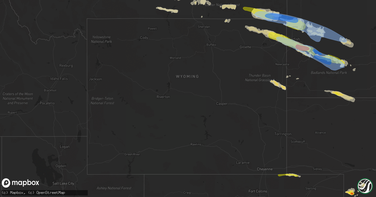
Hail Map in Wyoming on July 10, 2022
Get this storm
July 10 map
$229
one time, instant access
Download today. No call, no setup
Keep the $229
Bought the map and want the full workflow? Apply the entire $229 to a subscription within 7 days. None of it is wasted.
Every map, not just this one
This buys you this map. Subscription and you get every map we run, in the markets you choose from a few cities to whole states to nationwide. Plus real-time alerts the moment a storm fires.
Contact data
Name, contact info, occupancy, even credit band for addresses in the footprint. You go from where it hit to who to call.
Become the source they trust
Unlimited branding weather history reports on demand. You already have the documented answer ready for the property owner, and you are the one who showed up with it.
Property data and RoofTrace estimates
Pull up any address you have got, its value and the exact code rules for that jurisdiction, straight from One Click Code. Then RoofTrace estimates the squares, pitch, and roof value, priced the way you price.
Storm reports in Wyoming
Wyoming
| Date | Description |
|---|---|
| 07/10/20226:22 AM CDT | At 1122 PM MDT, a severe thunderstorm was located 9 miles southwest of Morrisey, or 32 miles southwest of Newcastle, moving east at 30 mph. HAZARD...60 mph wind gusts and half dollar size hail. SOURCE...Radar indicated. IMPACT...Hail damage to vehicles is expected. Expect wind damage to roofs, siding, and trees. Locations impacted include... Mule Creek Junction. |
| 07/10/20224:15 AM CDT | At 915 PM MDT, severe thunderstorms were located along a line extending from 2 miles east of Alva to 4 miles northwest of Warren Peak, moving east-southeast at 55 mph. HAZARD...60 mph wind gusts and half dollar size hail. SOURCE...Radar indicated. IMPACT...Hail damage to vehicles is expected. Expect wind damage to roofs, siding, and trees. Severe thunderstorms will be near... Bear Lodge Campground around 920 PM MDT. Sundance around 925 PM MDT. Aladdin around 930 PM MDT. Beulah around 935 PM MDT.Other locations in the path of these severe thunderstorms includeCement Ridge Lookout, Belle Fourche, Iron Creek Lake, Crow Peak,Spearfish, Savoy, Roughlock Falls, Bridal Veil Falls, SpearfishCanyon, Saint Onge, Central City, Cheyenne Crossing and Terry Peak.This includes... Interstate 90 in South Dakota between Mile Markers 1 and 41. Interstate 90 in Wyoming between Mile Markers 188 and 207. |
| 07/10/20223:35 AM CDT | At 835 PM MDT, a severe thunderstorm was located 7 miles west of Alzada, or 42 miles northwest of Belle Fourche, moving east at 50 mph. HAZARD...60 mph wind gusts and half dollar size hail. SOURCE...Radar indicated. IMPACT...Hail damage to vehicles is expected. Expect wind damage to roofs, siding, and trees. This severe thunderstorm will be near... Colony around 900 PM MDT. Antelope Butte around 920 PM MDT. Two Top Butte and Arpan around 935 PM MDT. |
| 07/10/20223:09 AM CDT | At 808 PM MDT, a severe thunderstorm was located 12 miles north of Lightning Flat, or 26 miles southeast of Broadus, moving east at 50 mph. HAZARD...Ping pong ball size hail and 60 mph wind gusts. SOURCE...Radar indicated. IMPACT...People and animals outdoors will be injured. Expect hail amd wind damage to roofs, siding, windows, and vehicles. This severe thunderstorm will remain over mainly rural areas of southern Carter and southeastern Powder River Counties, including the following locations... Albion, Boyes, Belle Creek, Alzada, Hammond and Ridge.This replaces the warning previously in effect for this area. |
| 07/10/20222:31 AM CDT | At 731 PM MDT, a severe thunderstorm was located 24 miles southwest of Broadus, moving east at 45 mph. HAZARD...60 mph wind gusts and quarter size hail. SOURCE...Radar indicated. IMPACT...Hail damage to vehicles is expected. Expect wind damage to roofs, siding, and trees. This severe thunderstorm will remain over mainly rural areas of southeastern Powder River County, including the following locations... Sonnette and Belle Creek. |
| 07/09/20229:45 PM CDT | A local report indicates 60 MPH wind near 15 NNW ALVA |
| 07/09/20227:44 PM CDT | A local report indicates 58 MPH wind near 23 NW SHERIDAN |
All States Impacted by Hail Map on July 10, 2022
Cities Impacted by Hail Map on July 10, 2022
- Padroni, CO
- Champion, NE
- Argyle, MN
- Stephen, MN
- Ayr, ND
- Buffalo, ND
- Hawley, MN
- Pelican Rapids, MN
- Detroit Lakes, MN
- Glyndon, MN
- Vergas, MN
- New York Mills, MN
- Barnesville, MN
- Perham, MN
- Audubon, MN
- Menahga, MN
- Lake Park, MN
- Sebeka, MN
- Frazee, MN
- Ponsford, MN
- Clearwater, NE
- Orchard, NE
- Valley City, ND
- Gordon, WI
- Solon Springs, WI
- Iowa, LA
- Backus, MN
- Dilworth, MN
- Moorhead, MN
- Woodville, TX
- Colfax, ND
- Barney, ND
- Hunter, ND
- Erie, ND
- Columbus Junction, IA
- Conesville, IA
- Wyola, MT
- Burwell, NE
- Moose Lake, MN
- Sturgeon Lake, MN
- Winnebago, MN
- Andover, MN
- Forest Lake, MN
- Circle Pines, MN
- Ewing, NE
- Pine River, MN
- Crosslake, MN
- Pequot Lakes, MN
- Singer, LA
- Odebolt, IA
- Ida Grove, IA
- Arthur, IA
- What Cheer, IA
- Greensburg, LA
- Grover, CO
- New Raymer, CO
- Bushnell, NE
- Neligh, NE
- Holyoke, CO
- Lance Creek, WY
- Sundance, WY
- Alva, WY
- Hulett, WY
- Lodge Grass, MT
- Bridger, MT
- Harcourt, IA
- Dayton, IA
- Ainsworth, IA
- Imperial, NE
- Piedmont, SD
- Collins, IA
- White Owl, SD
- Howes, SD
- Adams, MN
- Medina, TX
- Haxtun, CO
- Boerne, TX
- Devils Lake, ND
- Crary, ND
- Deridder, LA
- Broken Bow, NE
- Anselmo, NE
- Story City, IA
- Wells, MN
- Hartland, MN
- Aitkin, MN
- Bartlett, NE
- Zachary, LA
- Petersburg, NE
- Spalding, NE
- Albion, NE
- Merriman, NE
- Martin, SD
- Wounded Knee, SD
- Batesland, SD
- Manderson, SD
- Pine Ridge, SD
- Pitkin, LA
- Owanka, SD
- New Underwood, SD
- Puposky, MN
- Black River Falls, WI
- Merrillan, WI
- Stewart, MN
- Malcom, IA
- Montezuma, IA
- Kerrick, MN
- Kingsley, IA
- Le Mars, IA
- Merrill, IA
- Hinton, IA
- Remsen, IA
- Verdigre, NE
- Center, NE
- Winnetoon, NE
- Monroe, NE
- Platte Center, NE
- Genoa, NE
- Atkinson, NE
- Oneill, NE
- Kathryn, ND
- Spiritwood, ND
- Fingal, ND
- Ypsilanti, ND
- Sheldon, ND
- Enderlin, ND
- Sanborn, ND
- Wyndmere, ND
- Litchville, ND
- Marion, ND
- Nome, ND
- Mcleod, ND
- Leonard, ND
- Yarmouth, IA
- Mount Union, IA
- Delavan, MN
- Sugartown, LA
- Mittie, LA
- Ragley, LA
- Oakdale, LA
- Grant, LA
- Dry Creek, LA
- Longville, LA
- Newcastle, WY
- Crosby, MN
- Deweyville, TX
- Call, TX
- Onawa, IA
- Moorhead, IA
- Hammond, MT
- Broadus, MT
- Alzada, MT
- New Roads, LA
- Somerset, WI
- Stillwater, MN
- Silsbee, TX
- Kountze, TX
- Belgrade, NE
- Cedar Rapids, NE
- Saint Edward, NE
- Fullerton, NE
- Baytown, TX
- Belle Fourche, SD
- Franklinton, LA
- Quinn, SD
- Wall, SD
- Tower City, ND
- Wasta, SD
- Crosby, TX
- Georgetown, MN
- Gardner, ND
- Harwood, ND
- Fargo, ND
- Felton, MN
- Argusville, ND
- Sherburn, MN
- Vale, SD
- Newell, SD
- Union Center, SD
- Sturgis, SD
- Rapid City, SD
- Box Elder, SD
- Kadoka, SD
- Caputa, SD
- Nunn, CO
- Claxton, GA
- Oriska, ND
- Page, ND
- Clearmont, WY
- Slaughter, LA
- Ethel, LA
- Saint Xavier, MT
- Port Allen, LA
- Enders, NE
- Sherwood, ND
- Akeley, MN
- Bemidji, MN
- Ventress, LA
- Durand, WI
- Mondovi, WI
- Willow River, MN
- West Point, NE
- Watkins, IA
- Blairstown, IA
- Ogema, MN
- Metter, GA
- Buna, TX
- Arnaudville, LA
- Davenport, ND
- Mapleton, ND
- Hammond, WI
- Houlton, WI
- Marine On Saint Croix, MN
- New Richmond, WI
- Holyoke, MN
- Keswick, IA
- Sigourney, IA
- Webster, IA
- Harper, IA
- Tenstrike, MN
- Busby, MT
- Garryowen, MT
- Callaway, NE
- Starks, LA
- Rochert, MN
- Callaway, MN
- Petersburg, ND
- Grand Marais, MN
- Hines, MN
- Greeley, NE
- Scotia, NE
- Wolbach, NE
- Grafton, ND
- Osage, MN
- Park Rapids, MN
- Erwinville, LA
- Jarreau, LA
- Lakeland, LA
- Nichols, IA
- Lone Tree, IA
- Horace, ND
- Wheatland, ND
- Chelsea, IA
- Elberon, IA
- Wauneta, NE
- Craig, NE
- Oakland, NE
- Philip, SD
- Milesville, SD
- Custer, SD
- Hot Springs, SD
- Edgemont, SD
- Amite, LA
- Winfield, IA
- Crawfordsville, IA
- Washington, IA
- Olds, IA
- Mount Pleasant, IA
- Wayland, IA
- Brighton, IA
- Wapello, IA
- Morning Sun, IA
- Austin, TX
- Paoli, CO
- Amherst, CO
- Sour Lake, TX
- Elsie, NE
- Hayes Center, NE
- Madrid, NE
- Marengo, IA
- Tylertown, MS
- Boone, IA
- Ames, IA
- Gilman, IA
- Hartwick, IA
- Montour, IA
- Deep River, IA
- Parnell, IA
- Brooklyn, IA
- Tama, IA
- Wellman, IA
- North English, IA
- Guernsey, IA
- Ladora, IA
- Williamsburg, IA
- Belle Plaine, IA
- South English, IA
- Kalona, IA
- Grinnell, IA
- Victor, IA
- Fordville, ND
- West Fargo, ND
- Birney, MT
- Amana, IA
- Norway, IA
- Keota, IA
- Forest Hill, LA
- Spring, TX
- Houston, TX
- Breaux Bridge, LA
- Gothenburg, NE
- Brady, NE
- Dent, MN
- Henderson, MN
- Green Isle, MN
- Ellsworth Afb, SD
- Rothsay, MN
- Wolverton, MN
- Neillsville, WI
- Deerwood, MN
- Nisland, SD
- Spearfish, SD
- Lead, SD
- Moorcroft, WY
- Deadwood, SD
- Whitewood, SD
- Devils Tower, WY
- Weston, WY
- Aladdin, WY
- Beulah, WY
- Black Hawk, SD
- Nemo, SD
- Decatur, NE
- Tekamah, NE
- Stapleton, NE
- Arnold, NE
- Merna, NE
- Casselton, ND
- Nevis, MN
- Armstrong Creek, WI
- Argonne, WI
- Conrad, IA
- Staples, MN
- Verndale, MN
- Rose Creek, MN
- West Chester, IA
- Fairmont, MN
- Welcome, MN
- Lake City, IA
- Lake View, IA
- Gowrie, IA
- Stratford, IA
- Auburn, IA
- Breda, IA
- Rockwell City, IA
- Kiron, IA
- Farnhamville, IA
- Carroll, IA
- Wall Lake, IA
- Lohrville, IA
- Borup, MN
- Boyes, MT
- Batchelor, LA
- Morganza, LA
- Strum, WI
- Whitehall, WI
- Eleva, WI
- Independence, WI
- Osseo, WI
- Bon Wier, TX
- Sioux City, IA
- Ironton, MN
- Otter, MT
- Merryville, LA
- Granada, MN
- Rose Hill, IA
- Delta, IA
- Vanderpool, TX
- Colo, IA
- Zearing, IA
- Jewell, IA
- Melbourne, IA
- Rhodes, IA
- Marshalltown, IA
- Stanhope, IA
- McCallsburg, IA
- State Center, IA
- Roland, IA
- Saint Anthony, IA
- Clemons, IA
- Nevada, IA
- Riceville, IA
- McIntire, IA
- Lumberton, TX
- International Falls, MN
- Sterling, CO
- Newman Grove, NE
- Maywood, NE
- Jackson, LA
- Saint Francisville, LA
- Lyle, MN
- White River, SD
- Long Valley, SD
- Wanblee, SD
- Van Horne, IA
- Keystone, IA
- Luzerne, IA
- Kentwood, LA
- Midland, SD
- Dayton, TX
- Center Point, TX
- Curtis, NE
- Vidor, TX
- Stacyville, IA
- Riverside, IA
- Columbus, MT
- Enning, SD
- Amelia, NE
- Austin, MN
- Albert Lea, MN
- Decker, MT
- Elma, IA
- Taopi, MN
- Kellogg, IA
- Gilbert, IA
- Muscatine, IA
- Haverhill, IA
- Letts, IA
- Millersburg, IA
- New Boston, IL
- Fruitland, IA
- Illinois City, IL
- Scenic, SD
- Hermosa, SD
- Jamestown, ND
- Cleveland, ND
- Medina, ND
- Niagara, ND
- Manvel, ND
- Red Lake Falls, MN
- East Grand Forks, MN
- Finley, ND
- Mcville, ND
- Emerado, ND
- Thompson, ND
- Jessie, ND
- Arvilla, ND
- Mchenry, ND
- Reynolds, ND
- Grand Forks, ND
- Newfolden, MN
- New Rockford, ND
- Michigan, ND
- Sharon, ND
- Grand Forks Afb, ND
- Larimore, ND
- Middle River, MN
- Pekin, ND
- Mekinock, ND
- Hope, ND
- Warren, MN
- Thief River Falls, MN
- Warwick, ND
- Viking, MN
- Plummer, MN
- Crookston, MN
- Gatzke, MN
- Cooperstown, ND
- Brooks, MN
- Cummings, ND
- Mayville, ND
- Fisher, MN
- Northwood, ND
- Aneta, ND
- Goodridge, MN
- Lakota, ND
- Glenfield, ND
- Tolna, ND
- Hatton, ND
- Portland, ND
- Mentor, MN
- Grygla, MN
- Euclid, MN
- Saint Hilaire, MN
- Climax, MN
- Binford, ND
- Buxton, ND
- Shevlin, MN
- Solway, MN
- Ulen, MN
- Ada, MN
- Cass Lake, MN
- Lake George, MN
- Bejou, MN
- Mahnomen, MN
- Fosston, MN
- Gary, MN
- Bagley, MN
- Naytahwaush, MN
- Twin Valley, MN
- Lengby, MN
- Hitterdal, MN
- Sabin, MN
- Waubun, MN
- White Earth, MN
- Perley, MN
- Laporte, MN
- Arlington, NE
- Paton, IA
- Humphrey, NE
- Kelley, IA
- Missouri Valley, IA
- Manning, IA
- Beaver, IA
- Rogers, NE
- Earling, IA
- Lyons, NE
- Madison, NE
- Denison, IA
- Ralston, IA
- Charter Oak, IA
- Woodward, IA
- Lidderdale, IA
- Modale, IA
- Rippey, IA
- Halbur, IA
- Vail, IA
- Churdan, IA
- Hooper, NE
- Howells, NE
- Irwin, IA
- Blencoe, IA
- Glidden, IA
- Madrid, IA
- Luther, IA
- Aspinwall, IA
- Perry, IA
- Dow City, IA
- Woodbine, IA
- Linwood, NE
- Boxholm, IA
- Dedham, IA
- Scribner, NE
- Manilla, IA
- Pisgah, IA
- Little Sioux, IA
- Schuyler, NE
- Scranton, IA
- Ute, IA
- Coon Rapids, IA
- North Bend, NE
- Bagley, IA
- Jamaica, IA
- Mondamin, IA
- Nickerson, NE
- Kennard, NE
- Logan, IA
- Dunlap, IA
- Lindsay, NE
- Westside, IA
- Stanton, NE
- Dana, IA
- Defiance, IA
- Herman, NE
- Magnolia, IA
- Wisner, NE
- Creston, NE
- Fort Calhoun, NE
- Jefferson, IA
- Grand Junction, IA
- Morse Bluff, NE
- Winslow, NE
- Snyder, NE
- Panama, IA
- Columbus, NE
- Clarkson, NE
- Portsmouth, IA
- Pilot Mound, IA
- Ames, NE
- Uehling, NE
- Leigh, NE
- Ogden, IA
- Arion, IA
- Blair, NE
- Deloit, IA
- Templeton, IA
- Arcadia, IA
- Dodge, NE
- Soldier, IA
- Fremont, NE
- Persia, IA
- Walcott, ND
- Wahpeton, ND
- Hereford, CO


