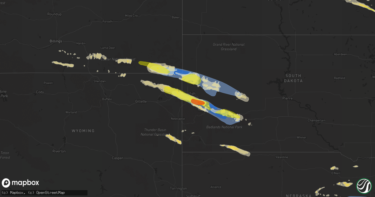
Hail Map on July 10, 2022
Get this storm
July 10 map
$229
one time, instant access
Download today. No call, no setup
Keep the $229
Bought the map and want the full workflow? Apply the entire $229 to a subscription within 7 days. None of it is wasted.
Every map, not just this one
This buys you this map. Subscription and you get every map we run, in the markets you choose from a few cities to whole states to nationwide. Plus real-time alerts the moment a storm fires.
Contact data
Name, contact info, occupancy, even credit band for addresses in the footprint. You go from where it hit to who to call.
Become the source they trust
Unlimited branding weather history reports on demand. You already have the documented answer ready for the property owner, and you are the one who showed up with it.
Property data and RoofTrace estimates
Pull up any address you have got, its value and the exact code rules for that jurisdiction, straight from One Click Code. Then RoofTrace estimates the squares, pitch, and roof value, priced the way you price.
States Impacted by Hail Map on July 10, 2022
Storm reports
Minnesota
| Date | Description |
|---|---|
| 07/10/20225:00 PM CDT | Report of tree down over a portion of highway 48 east of cloverdale. Time estimated by radar. |
| 07/10/20224:39 PM CDT | A portion of interstate 35 southbound lane was blocked by a large fallen tree. Time estimated by radar. |
| 07/10/20224:36 PM CDT | Two large spruce trees were downed with at least one uprooted. Report and photo relayed via social media. Time estimated by radar. |
| 07/10/20224:35 PM CDT | Photos sent in via social media of a cluster of trees that snapped near the trunk as well as a spruce tree that was uprooted. Time is approximated from radar. |
| 07/10/20223:18 PM CDT | Report from mping: quarter |
| 07/10/20221:45 PM CDT | Pea to quarter size hail. |
| 07/10/20221:40 PM CDT | Relayed via broadcast media partner. Time estimated via radar. |
| 07/10/20221:33 PM CDT | Relayed via broadcast media partner. |
| 07/10/20221:33 PM CDT | Relayed via broadcast media partner. |
| 07/10/20221:29 PM CDT | Relayed via broadcast media partner. |
| 07/10/20221:23 PM CDT | Estimated size from picture shared on social media. |
| 07/10/20221:18 PM CDT | Corrects previous hail report from 3 nnw cormorant. Relayed via broadcast media partner. Time estimated via radar. |
| 07/10/20221:00 PM CDT | A local report indicates 1.00 inch wind near 5 SE RICHWOOD |
| 07/10/202212:45 PM CDT | Size estimated by picture shared on social media. |
| 07/10/202211:10 AM CDT | Cass county dispatch reported a large tree down across a road south of remer. Time estimated by radar. |
| 07/10/202210:40 AM CDT | Cass county dispatch reported a power line down near hackensack. Time estimated by radar. |
| 07/10/20229:10 AM CDT | Corrects previous tstm wnd gst report from waukon. Ndawn report of 59mph wind gust. |
| 07/10/20228:33 AM CDT | Tree on house and car in newfolden. Time estimated. |
| 07/10/20228:26 AM CDT | Reported via a personal weather station. |
| 07/10/20228:19 AM CDT | Tree branches down and fence posts blown down. |
| 07/10/20228:06 AM CDT | Wind gust via personal weather station. |
| 07/10/20227:38 AM CDT | At 1237 PM CDT, a severe thunderstorm was located over Richwood, or 8 miles north of Detroit Lakes, moving east at 30 mph. HAZARD...60 mph wind gusts and quarter size hail. SOURCE...Radar indicated. IMPACT...Hail damage to vehicles is expected. Expect wind damage to roofs, siding, and trees. This severe thunderstorm will be near... Richwood around 1240 PM CDT. Detroit Lakes around 1245 PM CDT.Other locations in the path of this severe thunderstorm includeRochert, Height Of Land Lake and Toad Lake. |
| 07/10/20225:54 AM CDT | At 1051 AM CDT, severe thunderstorms were located along a line extending from near Bena, to near Longville, to near Pequot Lakes, moving east at 55 mph. HAZARD...60 mph wind gusts and quarter size hail. SOURCE...Radar indicated. IMPACT...Hail damage to vehicles is expected. Expect wind damage to roofs, siding, and trees. Severe thunderstorms will be near... Crosslake around 1100 AM CDT. Fifty Lakes, Remer and Ball Club around 1105 AM CDT. Days High Landing around 1110 AM CDT.Other locations in the path of these severe thunderstorms includeDeer River, Zemple, Hill City, Pokegama Dam, Grand Rapids, Coleraine,Taconite, Palisade, Gunn and Jacobson. |
| 07/10/20225:17 AM CDT | At 1017 AM CDT, severe thunderstorms were located along a line extending from near Bemidji, to near Akeley, to near Sebeka, moving east at 55 mph. HAZARD...60 mph wind gusts and quarter size hail. SOURCE...Radar indicated. IMPACT...Hail damage to vehicles is expected. Expect wind damage to roofs, siding, and trees. Severe thunderstorms will be near... Walker around 1025 AM CDT. Poplar around 1030 AM CDT. Leader around 1035 AM CDT.Other locations in the path of these severe thunderstorms includeWoman Lake, Longville, Leech Lake, Boy River, Gull Lake, PequotLakes, Nisswa, Breezy Point, Remer and Lake Winnibigoshish. |
| 07/10/20225:15 AM CDT | At 1015 AM CDT, severe thunderstorms were located along a line extending from Lavinia to Akeley to near Sebeka, moving east at 75 mph. HAZARD...70 mph wind gusts and quarter size hail. SOURCE...Radar indicated. IMPACT...Hail damage to vehicles is expected. Expect considerable tree damage. Wind damage is also likely to mobile homes, roofs, and outbuildings. Severe thunderstorms will be near... Pennington around 1030 AM CDT. |
| 07/10/20225:14 AM CDT | At 1013 AM CDT, severe thunderstorms were located along a line extending from Baudette, to Upper Red Lake, to 6 miles east of Lavinia, moving east at 45 mph. HAZARD...60 mph wind gusts and quarter size hail. SOURCE...Radar indicated. IMPACT...Hail damage to vehicles is expected. Expect wind damage to roofs, siding, and trees. Locations impacted include... Birchdale, Lake Winnibigoshish, Manitou, Inger, Margie and Ball Club. |
| 07/10/20225:04 AM CDT | At 1004 AM CDT, severe thunderstorms were located along a line extending from near Birch Beach to 11 miles southeast of Oaks Corner to near Wilton, moving east at 35 mph. HAZARD...60 mph wind gusts and quarter size hail. SOURCE...Radar indicated. IMPACT...Hail damage to vehicles is expected. Expect wind damage to roofs, siding, and trees. Severe thunderstorms will be near... Lavinia around 1015 AM CDT. Wheelers Point around 1020 AM CDT.Other locations in the path of these severe thunderstorms includeTurtle River and Tenstrike. |
| 07/10/20224:24 AM CDT | At 924 AM CDT, severe thunderstorms were located along a line extending from near Fosston to White Earth Nation to Lake Lida, moving east at 55 mph. HAZARD...60 mph wind gusts and quarter size hail. SOURCE...Radar indicated. IMPACT...Hail damage to vehicles is expected. Expect wind damage to roofs, siding, and trees. Severe thunderstorms will be near... Lengby, Many Point Lake and Island Lake in Mahnomen County around 930 AM CDT. Ebro, Dent and Vergas around 935 AM CDT. Pine Point, Ponsford and Richville around 940 AM CDT.Other locations in the path of these severe thunderstorms includeBagley, Perham, Shevlin and Two Inlets. |
| 07/10/20224:09 AM CDT | At 909 AM CDT, severe thunderstorms were located along a line extending from near Badger to Red Lake Nation to near McIntosh, moving east at 50 mph. HAZARD...60 mph wind gusts and quarter size hail. SOURCE...Radar indicated. IMPACT...Hail damage to vehicles is expected. Expect wind damage to roofs, siding, and trees. Severe thunderstorms will be near... Red Lake Nation around 910 AM CDT. Malung, Gully and Wannaska around 920 AM CDT. Weme, Pencer and Gonvick around 925 AM CDT.Other locations in the path of these severe thunderstorms includeClearbrook, Thorhult, Upper Red Lake and Leonard. |
| 07/10/20223:22 AM CDT | At 822 AM CDT, severe thunderstorms were located along a line extending from 6 miles west of Lake Bronson to near Carpenters Corner to Greenview, moving east at 55 mph. HAZARD...60 mph wind gusts and quarter size hail. SOURCE...Radar indicated. IMPACT...Hail damage to vehicles is expected. Expect wind damage to roofs, siding, and trees. Severe thunderstorms will be near... Harold and Carpenters Corner around 825 AM CDT. Melvin and Rosewood around 830 AM CDT. Thief River Falls, St. Hilaire and Dakota Junction around 835 AM CDT. Maple Bay, Hazel and Dugdale around 840 AM CDT.Other locations in the path of these severe thunderstorms includeMavie and Mentor. |
| 07/10/20221:16 AM CDT | At 616 AM CDT, a severe thunderstorm was located 7 miles east of Gunflint Lake, moving southeast at 30 mph. HAZARD...Ping pong ball size hail and 60 mph wind gusts. SOURCE...Radar indicated. IMPACT...People and animals outdoors will be injured. Expect hail damage to roofs, siding, windows, and vehicles. Expect wind damage to roofs, siding, and trees. This severe thunderstorm will be near... Hovland around 715 AM CDT.Other locations impacted by this severe thunderstorm include TomLake, Clearwater Lake, Bearskin Lake, Judge C. R. Magney State Park,Poplar Lake, Daniels Lake, North Lake, Judge Magney State Park, PineLake and Watab Lake. |
| 07/09/20229:15 PM CDT | At 215 PM CDT, severe thunderstorms were located along a line extending from Backus, to near Huntersville, moving east at 50 mph. HAZARD...Ping pong ball size hail and 60 mph wind gusts. SOURCE...Radar indicated. IMPACT...People and animals outdoors will be injured. Expect hail damage to roofs, siding, windows, and vehicles. Expect wind damage to roofs, siding, and trees. Severe thunderstorms will be near... Backus around 220 PM CDT.Other locations in the path of these severe thunderstorms includePine River, Emily, Outing, Pequot Lakes, Breezy Point, Crosslake andFifty Lakes. |
| 07/09/20229:08 PM CDT | At 207 PM CDT, a severe thunderstorm was located over Huntersville, or 46 miles east of Detroit Lakes, moving east at 35 mph. HAZARD...60 mph wind gusts and quarter size hail. SOURCE...Radar indicated. IMPACT...Hail damage to vehicles is expected. Expect wind damage to roofs, siding, and trees. This severe thunderstorm will be near... Badoura around 215 PM CDT. |
| 07/09/20228:56 PM CDT | At 155 PM CDT, severe thunderstorms were located along a line extending from near Hillview to near Lake Lida, moving east at 30 mph. HAZARD...Ping pong ball size hail and 60 mph wind gusts. SOURCE...Radar indicated. IMPACT...People and animals outdoors will be injured. Expect hail damage to roofs, siding, windows, and vehicles. Expect wind damage to roofs, siding, and trees. Severe thunderstorms will be near... Hillview and Midway around 200 PM CDT. Sebeka around 210 PM CDT.Other locations in the path of these severe thunderstorms includeBlue Grass, Richville, Perham and Ottertail. |
| 07/09/20228:39 PM CDT | At 139 PM CDT, a severe thunderstorm was located near Barnesville, or 23 miles southeast of Fargo, moving east at 50 mph. HAZARD...Quarter size hail. SOURCE...Radar indicated. IMPACT...Damage to vehicles is expected. This severe thunderstorm will be near... Barnesville around 140 PM CDT. Lawndale around 145 PM CDT. Rothsay around 155 PM CDT.Other locations in the path of this severe thunderstorm includePelican Rapids and Erhard.This includes Interstate 94 in Minnesota between mile markers 18 and47. |
| 07/09/20228:28 PM CDT | At 127 PM CDT, a severe thunderstorm was located over Shoreham, or near Detroit Lakes, moving southeast at 25 mph. HAZARD...60 mph wind gusts and quarter size hail. SOURCE...Radar indicated. IMPACT...Hail damage to vehicles is expected. Expect wind damage to roofs, siding, and trees. This severe thunderstorm will be near... Vergas and Frazee around 145 PM CDT.Other locations in the path of this severe thunderstorm include BigMcDonald Lake, Dent, northeastern Star Lake and Perham. |
| 07/09/20228:23 PM CDT | At 123 PM CDT, a severe thunderstorm was located near Snellman, or 23 miles east of Detroit Lakes, moving east at 30 mph. HAZARD...60 mph wind gusts and quarter size hail. SOURCE...Radar indicated. IMPACT...Hail damage to vehicles is expected. Expect wind damage to roofs, siding, and trees. This severe thunderstorm will be near... Osage around 130 PM CDT. Midway around 135 PM CDT.Other locations in the path of this severe thunderstorm includeMenahga, Park Rapids, Hubbard and Huntersville. |
Iowa
| Date | Description |
|---|---|
| 07/10/202211:06 AM CDT | A local report indicates 1.00 inch wind near RICEVILLE |
| 07/10/20226:41 AM CDT | Delayed report and time estimated from radar. 8 inch diameter limb down in a yard. |
| 07/10/20226:28 AM CDT | 2 inch branches down. |
| 07/10/20226:28 AM CDT | Reported dime to quarter sized hail via ham radio. |
| 07/10/20226:10 AM CDT | At 1109 AM CDT, a severe thunderstorm was located near Riceville, or 16 miles west of Cresco, moving southeast at 35 mph. HAZARD...Quarter size hail. SOURCE...Radar indicated. IMPACT...Damage to vehicles is expected. This severe thunderstorm will be near... Elma around 1115 AM CDT. Jerico around 1135 AM CDT. Protivin around 1145 AM CDT. Lawler around 1150 AM CDT.Other locations impacted by this severe thunderstorm include LylahsMarsh County Park, Saratoga, Maple Leaf, County Roads V 58 And A 46,Schley, Davis Corners and County Roads V 56 And B 33. |
| 07/10/20226:00 AM CDT | Delayed report. |
| 07/10/20225:08 AM CDT | Large tree limbs down in west ames. |
| 07/10/20225:05 AM CDT | Corrects previous tstm wnd gst report from 2 s ames. |
| 07/10/20225:03 AM CDT | 18 inch diameter tree snapped in half. Image posted on social media. Time estimated from radar. |
| 07/10/20224:49 AM CDT | Personal weather station kiabouto3. |
| 07/10/20224:47 AM CDT | A local report indicates 66 MPH wind near 2 E BOONE |
| 07/10/20224:46 AM CDT | Mesonet station fw3793 jefferson. |
| 07/10/20224:34 AM CDT | Tree limbs down in jefferson along with power out. |
| 07/10/20224:24 AM CDT | Personal weather station kiajeffe7. |
| 07/10/20224:20 AM CDT | Kcci tv meteorologist passed on gas station canopy damage. Partial collapse of structure. |
| 07/10/20224:20 AM CDT | Tree damage at spring lake park with some vehicles and campers stuck under trees. Delayed report... Time estimated via radar. |
| 07/10/20224:18 AM CDT | Personal weather station kiajeffe8. |
| 07/10/20224:05 AM CDT | A local report indicates 79 MPH wind near 3 WSW GLIDDEN |
| 07/10/20223:59 AM CDT | Personal weather station kiacarro21. |
| 07/10/20223:40 AM CDT | Lots of reports of trees down on local scanner in denison. Time estimated. |
| 07/10/20223:37 AM CDT | A local report indicates 69 MPH wind near 3 SW DENISON |
| 07/10/20223:15 AM CDT | Public reported via social media a downed 12 inch diameter tree branch that fell through a window. |
| 07/10/20222:49 AM CDT | A few small tree limbs broken and on roadways. Time estimated from radar. |
| 07/10/20222:40 AM CDT | A few small tree limbs broken and on roadways. Time estimated from radar. |
Wyoming
| Date | Description |
|---|---|
| 07/10/20226:22 AM CDT | At 1122 PM MDT, a severe thunderstorm was located 9 miles southwest of Morrisey, or 32 miles southwest of Newcastle, moving east at 30 mph. HAZARD...60 mph wind gusts and half dollar size hail. SOURCE...Radar indicated. IMPACT...Hail damage to vehicles is expected. Expect wind damage to roofs, siding, and trees. Locations impacted include... Mule Creek Junction. |
| 07/10/20224:15 AM CDT | At 915 PM MDT, severe thunderstorms were located along a line extending from 2 miles east of Alva to 4 miles northwest of Warren Peak, moving east-southeast at 55 mph. HAZARD...60 mph wind gusts and half dollar size hail. SOURCE...Radar indicated. IMPACT...Hail damage to vehicles is expected. Expect wind damage to roofs, siding, and trees. Severe thunderstorms will be near... Bear Lodge Campground around 920 PM MDT. Sundance around 925 PM MDT. Aladdin around 930 PM MDT. Beulah around 935 PM MDT.Other locations in the path of these severe thunderstorms includeCement Ridge Lookout, Belle Fourche, Iron Creek Lake, Crow Peak,Spearfish, Savoy, Roughlock Falls, Bridal Veil Falls, SpearfishCanyon, Saint Onge, Central City, Cheyenne Crossing and Terry Peak.This includes... Interstate 90 in South Dakota between Mile Markers 1 and 41. Interstate 90 in Wyoming between Mile Markers 188 and 207. |
| 07/10/20223:35 AM CDT | At 835 PM MDT, a severe thunderstorm was located 7 miles west of Alzada, or 42 miles northwest of Belle Fourche, moving east at 50 mph. HAZARD...60 mph wind gusts and half dollar size hail. SOURCE...Radar indicated. IMPACT...Hail damage to vehicles is expected. Expect wind damage to roofs, siding, and trees. This severe thunderstorm will be near... Colony around 900 PM MDT. Antelope Butte around 920 PM MDT. Two Top Butte and Arpan around 935 PM MDT. |
| 07/10/20223:09 AM CDT | At 808 PM MDT, a severe thunderstorm was located 12 miles north of Lightning Flat, or 26 miles southeast of Broadus, moving east at 50 mph. HAZARD...Ping pong ball size hail and 60 mph wind gusts. SOURCE...Radar indicated. IMPACT...People and animals outdoors will be injured. Expect hail amd wind damage to roofs, siding, windows, and vehicles. This severe thunderstorm will remain over mainly rural areas of southern Carter and southeastern Powder River Counties, including the following locations... Albion, Boyes, Belle Creek, Alzada, Hammond and Ridge.This replaces the warning previously in effect for this area. |
| 07/10/20222:31 AM CDT | At 731 PM MDT, a severe thunderstorm was located 24 miles southwest of Broadus, moving east at 45 mph. HAZARD...60 mph wind gusts and quarter size hail. SOURCE...Radar indicated. IMPACT...Hail damage to vehicles is expected. Expect wind damage to roofs, siding, and trees. This severe thunderstorm will remain over mainly rural areas of southeastern Powder River County, including the following locations... Sonnette and Belle Creek. |
| 07/09/20229:45 PM CDT | A local report indicates 60 MPH wind near 15 NNW ALVA |
| 07/09/20227:44 PM CDT | A local report indicates 58 MPH wind near 23 NW SHERIDAN |
Montana
| Date | Description |
|---|---|
| 07/10/20227:51 AM CDT | At 1250 AM CDT, severe thunderstorms were located along a line extending from 5 miles northwest of Westby to 13 miles northeast of Medicine Lake to Culbertson, moving east at 45 mph. HAZARD...70 mph wind gusts and nickel size hail. SOURCE...Radar indicated. IMPACT...Expect considerable tree damage. Damage is likely to mobile homes, roofs, and outbuildings. Severe thunderstorms will be near... Westby around 1155 PM MDT. Alkabo around 105 AM CDT. Grenora around 110 AM CDT. Fortuna around 115 AM CDT. Alamo around 140 AM CDT. Williston around 145 AM CDT.Other locations impacted by these severe thunderstorms include Zahl, Fort Buford State Historical Site, Appam, Hanks, Ambrose, Trenton, and Blacktail Lake. |
| 07/10/20227:45 AM CDT | At 1245 AM MDT, severe thunderstorms were located along a line extending from 10 miles northwest of Wibaux to 9 miles northwest of Golva to 7 miles north of Baker, moving east at 60 mph. HAZARD...70 mph wind gusts and ping pong ball size hail. SOURCE...Radar indicated. IMPACT...People and animals outdoors will be injured. Expect hail damage to roofs, siding, windows, and vehicles. Expect considerable tree damage. Wind damage is also likely to mobile homes, roofs, and outbuildings. Severe thunderstorms will be near... Golva around 1250 AM MDT. Beach around 1255 AM MDT. Sentinel Butte around 100 AM MDT. Medora around 115 AM MDT. Belfield around 130 AM MDT.Other locations impacted by these severe thunderstorms include Alpha,Fryburg, Fairfield, Three V Crossing, and Pretty Butte. |
| 07/10/20227:24 AM CDT | At 1222 AM MDT, severe thunderstorms were located along a line extending from 13 miles east of Fallon to 27 miles west of Baker, moving east at 70 mph. HAZARD...70 mph wind gusts and half dollar size hail. SOURCE...Radar indicated. IMPACT...Hail damage to vehicles is expected. Expect considerable tree damage. Wind damage is also likely to mobile homes, roofs, and outbuildings. Locations impacted include... Glendive, Terry, Wibaux, Fallon, West Glendive, Intake, Carlyle, Lindsay, Hoyt, Saint Phillip, Yates, Hodges, Mildred, Calypso, Forest Park, Stipek and Marsh. |
| 07/10/20227:20 AM CDT | At 1219 AM MDT, severe thunderstorms were located along a line extending from near Westby to near Fort Union Trading Post, moving east at 25 mph. HAZARD...60 mph wind gusts and quarter size hail. SOURCE...Radar indicated. IMPACT...Hail damage to vehicles is expected. Expect wind damage to roofs, siding, and trees. Locations impacted include... Plentywood, Culbertson, Medicine Lake, Bainville, Froid, Westby, Port Of Raymond, Reserve, Raymond, Snowden, Dagmar, Fort Kipp, Homestead, Dooley, Comertown, Mccabe, Antelope and Coalridge. |
| 07/10/20222:51 AM CDT | At 751 PM MDT, a severe thunderstorm was located 11 miles north of Spotted Horse, or 46 miles northwest of Gillette, moving east at 55 mph. HAZARD...60 mph wind gusts and quarter size hail. SOURCE...Radar indicated. IMPACT...Hail damage to vehicles is expected. Expect wind damage to roofs, siding, and trees. Locations impacted include... Lightning Flat, Oshoto, Weston, Recluse and Rockypoint. |
| 07/09/20229:46 PM CDT | A local report indicates 78 MPH wind near 3 SE ALZADA |
| 07/09/20229:30 PM CDT | Heavy rain and gusty winds. |
| 07/09/20228:56 PM CDT | 8 to 10 inch diameter tree limbs broken off. |
| 07/09/20228:27 PM CDT | A local report indicates 62 MPH wind near 7 NNE OTTER |
South Dakota
| Date | Description |
|---|---|
| 07/10/20226:53 AM CDT | At 1152 PM MDT, a severe thunderstorm was located near Redbird, or 19 miles west of Edgemont, moving southeast at 25 mph. HAZARD...60 mph wind gusts and half dollar size hail. SOURCE...Radar indicated. IMPACT...Hail damage to vehicles is expected. Expect wind damage to roofs, siding, and trees. Locations impacted include... Redbird. |
| 07/10/20226:12 AM CDT | At 1111 PM MDT, severe thunderstorms were located along a line extending from 3 miles north of Wasta to Scenic, moving east at 55 mph. HAZARD...70 mph wind gusts and quarter size hail. SOURCE...Radar indicated. IMPACT...Hail damage to vehicles is expected. Expect considerable tree damage. Wind damage is also likely to mobile homes, roofs, and outbuildings. Severe thunderstorms will be near... Wall around 1125 PM MDT. Quinn and Delta 9 Missile Silo around 1130 PM MDT.Other locations in the path of these severe thunderstorms include Cottonwood, Interior, Potato Creek, Kadoka, Wanblee, Eagle Nest Butte, Intersection of Highway 73 and White River, and Long Valley.This includes Interstate 90 in South Dakota between Mile Markers 90and 172. |
| 07/10/20225:30 AM CDT | At 1030 PM MDT, severe thunderstorms were located along a line extending from 12 miles southwest of Durkee Lake to 5 miles northeast of Elm Springs, moving east at 65 mph. HAZARD...70 mph wind gusts and quarter size hail. SOURCE...Radar indicated. IMPACT...Hail damage to vehicles is expected. Expect considerable tree damage. Wind damage is also likely to mobile homes, roofs, and outbuildings. Locations impacted include... Cherry Creek, Milesville, Midland, Plainview, Enning, Elm Springs, Ottumwa, Creighton, Marcus, Bridger, Howes, Kirley, White Owl, Red Scaffold, Billsburg, Takini, Grindstone Butte and Nowlin. |
| 07/10/20225:15 AM CDT | At 1014 PM MDT, severe thunderstorms were located along a line extending from near Fort Meade to 3 miles southwest of Nemo, moving east at 55 mph. HAZARD...60 mph wind gusts and half dollar size hail. SOURCE...Radar indicated. IMPACT...Hail damage to vehicles is expected. Expect wind damage to roofs, siding, and trees. Severe thunderstorms will be near... Summerset, Johnson Siding and Piedmont around 1020 PM MDT. Black Hawk around 1025 PM MDT. Rapid City around 1030 PM MDT.Other locations in the path of these severe thunderstorms includeRapid Valley, Ellsworth Air Force Base, Box Elder, Rapid CityAirport, Caputa, Farmingdale, Viewfield and Curlew Lake.This includes Interstate 90 in South Dakota between Mile Markers 30and 98. |
| 07/10/20224:24 AM CDT | At 924 PM MDT, severe thunderstorms were located along a line extending from 5 miles northeast of Haystack Buttes to 3 miles west of Nisland, moving east at 65 mph. HAZARD...70 mph wind gusts and half dollar size hail. SOURCE...Radar indicated. IMPACT...Hail damage to vehicles is expected. Expect considerable tree damage. Wind damage is also likely to mobile homes, roofs, and outbuildings. Severe thunderstorms will be near... Newell and Hoover around 930 PM MDT. Vale and Dears Ears Butte around 935 PM MDT. Owl Butte around 940 PM MDT.Other locations in the path of these severe thunderstorms include MudButte, Maurine and Opal. |
| 07/10/20221:26 AM CDT | Asos station kpir pierre muni ap. |
| 07/10/20221:18 AM CDT | A local report indicates 61 MPH wind near 7 E WANBLEE |
| 07/10/20221:11 AM CDT | A local report indicates 58 MPH wind near 1 NE MIDLAND |
| 07/10/202212:47 AM CDT | A local report indicates 69 MPH wind near 4 W OTTUMWA |
| 07/10/202212:34 AM CDT | A local report indicates 69 MPH wind near 4 W OTTUMWA |
| 07/10/202212:30 AM CDT | A local report indicates 58 MPH wind near 3 NNW SCENIC |
| 07/10/202212:20 AM CDT | A local report indicates 79 MPH wind near 3 NNW SCENIC |
| 07/10/202212:17 AM CDT | A local report indicates 59 MPH wind near 8 SSW FOLSOM |
| 07/09/202211:57 PM CDT | A local report indicates 60 MPH wind near RAPID CITY ARPT |
| 07/09/202211:52 PM CDT | A local report indicates 79 MPH wind near 5 WNW NEW UNDERWOOD |
| 07/09/202211:47 PM CDT | A local report indicates 70 MPH wind near 5 WNW NEW UNDERWOOD |
| 07/09/202211:45 PM CDT | A local report indicates 75 MPH wind near RAPID CITY ARPT |
| 07/09/202211:44 PM CDT | A local report indicates 1.00 inch wind near 4 WNW RAPID CITY ARPT |
| 07/09/202211:40 PM CDT | A local report indicates 74 MPH wind near RAPID CITY ARPT |
| 07/09/202211:40 PM CDT | A local report indicates 67 MPH wind near 1 W BOX ELDER |
| 07/09/202211:39 PM CDT | A local report indicates 62 MPH wind near ELLSWORTH AFB |
| 07/09/202211:39 PM CDT | A local report indicates 58 MPH wind near 6 NE SUMMERSET |
| 07/09/202211:36 PM CDT | A local report indicates 62 MPH wind near ELLSWORTH AFB |
| 07/09/202211:36 PM CDT | A local report indicates 61 MPH wind near 1 E DWTN RAPID CITY |
| 07/09/202211:35 PM CDT | A local report indicates 60 MPH wind near 1 W BOX ELDER |
| 07/09/202211:32 PM CDT | A local report indicates 61 MPH wind near ELLSWORTH AFB |
| 07/09/202211:24 PM CDT | A local report indicates 1.50 inch wind near 4 NW BLACK HAWK |
| 07/09/202211:20 PM CDT | A local report indicates 58 MPH wind near 1 NNW PIEDMONT |
| 07/09/202211:20 PM CDT | A local report indicates 70 MPH wind near 3 W UNION CENTER |
| 07/09/202211:20 PM CDT | A local report indicates 1.50 inch wind near 1 NNW PIEDMONT |
| 07/09/202211:15 PM CDT | A local report indicates 60 MPH wind near 3 W UNION CENTER |
| 07/09/202210:51 PM CDT | A local report indicates 61 MPH wind near 4 NW CHEYENNE CROSSING |
| 07/09/202210:40 PM CDT | A local report indicates 1.00 inch wind near 9 W DWTN SPEARFISH |
| 07/09/202210:25 PM CDT | A local report indicates 66 MPH wind near 12 WSW CASTLE ROCK |
Colorado
| Date | Description |
|---|---|
| 07/10/20225:42 PM CDT | Delayed report. Up to golf ball sized hail fell just northeast of the north sterling reservoir. Most hail was quarter size or smaller. Time estimated by radar. |
| 07/10/20227:59 AM CDT | At 1259 PM MDT, a severe thunderstorm was located over Schriever AFB, or 13 miles east of Colorado Springs, moving east at 5 mph. HAZARD...60 mph wind gusts and penny size hail. SOURCE...Radar indicated. IMPACT...Expect damage to roofs, siding, and trees. Locations impacted include... Eastern Colorado Springs, Schriever AFB, Peterson AFB and Cimarron Hills. |
| 07/10/20221:47 AM CDT | At 647 PM MDT, severe thunderstorms were located along a line extending from near Truckton to 12 miles southeast of Hanover to Pueblo Depot, moving east at 35 mph. HAZARD...70 mph wind gusts. SOURCE...Radar indicated. IMPACT...Expect considerable tree damage. Damage is likely to mobile homes, roofs, and outbuildings. Locations impacted include... Pueblo Depot and Truckton. |
| 07/10/20221:13 AM CDT | At 612 PM MDT, severe thunderstorms were located along a line extending from near Peyton to Schriever AFB to near Fountain, moving southeast at 40 mph. HAZARD...60 mph wind gusts. SOURCE...Radar indicated. At 557 PM, 66 mph was reported at the Colorado Spring Airport. IMPACT...Expect damage to roofs, siding, and trees. Locations impacted include... Colorado Springs, Fountain, Hanover, Truckton, Yoder, Black Forest, Ellicott, Peyton, Schriever AFB, Security, Falcon, Security-Widefield, Stratmoor, Fort Carson, Peterson AFB and Cimarron Hills. |
| 07/09/202211:43 PM CDT | At 443 PM MDT, a severe thunderstorm was located 4 miles north of North Sterling Reservoir, or 16 miles north of Sterling, moving east at 15 mph. HAZARD...60 mph wind gusts and half dollar size hail. SOURCE...Radar indicated. IMPACT...Expect damage to roofs, siding, and trees. Hail damage to vehicles is expected. This severe thunderstorm will be near... Padroni around 500 PM MDT.Other locations in the path of this severe thunderstorm includeIliff. |
| 07/09/202211:30 PM CDT | At 429 PM MDT, a severe thunderstorm was located 9 miles north of New Raymer, or 30 miles west of Sterling, moving northeast at 20 mph. HAZARD...60 mph wind gusts and quarter size hail. SOURCE...Radar indicated. IMPACT...Expect damage to roofs, siding, and trees. Hail damage to vehicles is expected. This severe thunderstorm will remain over mainly rural areas of northeastern Weld and west central Logan Counties. |
| 07/09/202210:58 PM CDT | At 357 PM MDT, a severe thunderstorm was located 6 miles northwest of Westplains, or 20 miles south of Kimball, moving east at 25 mph. HAZARD...60 mph wind gusts and penny size hail. SOURCE...Radar indicated. IMPACT...Expect damage to roofs, siding, and trees. This severe thunderstorm will be near... Westplains around 405 PM MDT. |
| 07/09/202210:15 PM CDT | At 315 PM MDT, a severe thunderstorm was located 9 miles southeast of Panorama Point, or 22 miles southwest of Kimball, moving east at 35 mph. HAZARD...60 mph wind gusts and nickel size hail. SOURCE...Radar indicated. IMPACT...Expect damage to roofs, siding, and trees. Locations impacted include... Westplains. |
| 07/09/20229:47 PM CDT | At 247 PM MDT, a severe thunderstorm was located near Hereford, or 30 miles southeast of Cheyenne, moving east at 30 mph. HAZARD...60 mph wind gusts and nickel size hail. SOURCE...Radar indicated. IMPACT...Expect damage to roofs, siding, and trees. Locations impacted include... Pawnee Buttes. |
| 07/09/20228:26 PM CDT | At 126 PM MDT, a severe thunderstorm was located near Schriever AFB, or 19 miles east of Colorado Springs, moving east at 10 mph. HAZARD...60 mph wind gusts and penny size hail. SOURCE...Radar indicated. IMPACT...Expect damage to roofs, siding, and trees. Locations impacted include... Eastern Colorado Springs, Schriever AFB, Ellicott and Falcon. |
| 07/09/20227:05 PM CDT | Asos station kcos colorado springs airport. |
North Dakota
| Date | Description |
|---|---|
| 07/10/20222:21 PM CDT | A local report indicates 1.25 inch wind near 3 SSW GALCHUTT |
| 07/10/20221:28 PM CDT | Relayed via media partner. |
| 07/10/20221:15 PM CDT | Corrects previous hail report from enderlin. Pea to quarter size hail. Time estimated. |
| 07/10/20221:14 PM CDT | A local report indicates 1.00 inch wind near 1 WNW ENDERLIN |
| 07/10/20221:00 PM CDT | Pea to quarter size hail. Time estimated. |
| 07/10/20228:11 AM CDT | Ndawn wind gust of 60mph at 10 meters. |
| 07/10/20228:05 AM CDT | Tree branches down... Relayed via facebook. Time estimated from radar. |
| 07/10/20227:59 AM CDT | At 1258 AM MDT, a severe thunderstorm was located 7 miles south of Carlyle, or 15 miles northeast of Baker, moving east at 50 mph. HAZARD...70 mph wind gusts and quarter size hail. SOURCE...Radar indicated. IMPACT...Hail damage to vehicles is expected. Expect considerable tree damage. Wind damage is also likely to mobile homes, roofs, and outbuildings. Locations impacted include... Baker and Ollie. This replaces the warning previously in effect for this area. |
| 07/10/20227:53 AM CDT | 58mph wind gust reported at the gfk airport. |
| 07/10/20227:42 AM CDT | At 1242 PM CDT, a severe thunderstorm was located over Hastings, or 15 miles south of Valley City, moving southeast at 30 mph. HAZARD...60 mph wind gusts and quarter size hail. SOURCE...Radar indicated. IMPACT...Hail damage to vehicles is expected. Expect wind damage to roofs, siding, and trees. This severe thunderstorm will be near... Kathryn around 1250 PM CDT. Little Yellowstone around 1255 PM CDT.Other locations in the path of this severe thunderstorm include Nome,Lucca and Enderlin.This includes Interstate 94 in North Dakota between mile markers 295and 316. |
| 07/10/20227:37 AM CDT | Ndawn station measured 59mph wind gust at 10 meters. |
| 07/10/20227:35 AM CDT | Rwis report of 68mph wind gust. |
| 07/10/20227:24 AM CDT | At 1224 PM CDT, a severe thunderstorm was located over West Fargo, or near Fargo, moving east at 25 mph. HAZARD...60 mph wind gusts and quarter size hail. SOURCE...Radar indicated. IMPACT...Hail damage to vehicles is expected. Expect wind damage to roofs, siding, and trees. This severe thunderstorm will be near... West Fargo and Reile's Acres around 1225 PM CDT. Fargo and Horace around 1230 PM CDT. Prairie Rose, Frontier and North River around 1235 PM CDT. Briarwood, Moorhead and Wild Rice around 1240 PM CDT.Other locations in the path of this severe thunderstorm includeDilworth and Rustad.This includes the following highways... Interstate 29 between mile markers 55 and 77. Interstate 94 in North Dakota between mile markers 337 and 352. Interstate 94 in Minnesota between mile markers 1 and 25. |
| 07/10/20227:10 AM CDT | At 1210 PM CDT, a severe thunderstorm was located over Tower City, or 15 miles east of Valley City, moving east at 35 mph. HAZARD...60 mph wind gusts and quarter size hail. SOURCE...Radar indicated. IMPACT...Hail damage to vehicles is expected. Expect wind damage to roofs, siding, and trees. This severe thunderstorm will be near... Buffalo around 1220 PM CDT. Ayr around 1225 PM CDT.Other locations in the path of this severe thunderstorm includeAbsaraka, Wheatland, Casselton and Amenia.This includes Interstate 94 in North Dakota between mile markers 301and 337. |
| 07/10/20223:33 AM CDT | At 833 AM CDT, severe thunderstorms were located along a line extending from near Shelly to near Kragnes to near Kindred, moving east at 55 mph. HAZARD...60 mph wind gusts and quarter size hail. SOURCE...Radar indicated. IMPACT...Hail damage to vehicles is expected. Expect wind damage to roofs, siding, and trees. Severe thunderstorms will be near... Lockhart and Averill around 840 AM CDT. Comstock, Wolverton and Felton around 845 AM CDT.Other locations in the path of these severe thunderstorms includeFlaming, Fertile, Hitterdal, Rindal, Barnesville, Ranum, White EarthNation and Lawndale.This includes the following highways... Interstate 29 between mile markers 42 and 68. Interstate 94 in North Dakota between mile markers 348 and 352. Interstate 94 in Minnesota between mile markers 1 and 35. |
| 07/10/20222:35 AM CDT | At 734 AM CDT, severe thunderstorms were located along a line extending from near Mandt to near Arvilla to near Sherbrooke, moving east at 55 mph. HAZARD...60 mph wind gusts and quarter size hail. SOURCE...Radar indicated. IMPACT...Hail damage to vehicles is expected. Expect wind damage to roofs, siding, and trees. Severe thunderstorms will be near... Emerado, Grand Forks AFB and Mekinock around 740 AM CDT. Portland, Mayville and Grand Forks around 750 AM CDT.Other locations in the path of these severe thunderstorms includeCashel, Mallory, East Grand Forks, Bygland, Davidson, Cummings andHillsboro.This includes Interstate 29 between mile markers 97 and 181. |
| 07/10/20221:59 AM CDT | At 658 AM CDT, a severe thunderstorm was located near Spiritwood, or 25 miles west of Valley City, moving east at 50 mph. HAZARD...60 mph wind gusts and quarter size hail. SOURCE...Radar indicated. IMPACT...Hail damage to vehicles is expected. Expect wind damage to roofs, siding, and trees. This severe thunderstorm will be near... Urbana around 705 AM CDT. Eckelson around 710 AM CDT. Sanborn around 715 AM CDT.Other locations in the path of this severe thunderstorm includeRogers and Bald Hill Dam.This includes Interstate 94 in North Dakota between mile markers 272and 307. |
| 07/10/20221:55 AM CDT | At 655 AM CDT, severe thunderstorms were located along a line extending from Edmore to 6 miles north of Pekin to Revere, moving east at 45 mph. HAZARD...60 mph wind gusts and nickel size hail. SOURCE...Radar indicated. IMPACT...Expect damage to roofs, siding, and trees. Severe thunderstorms will be near... McVille around 700 AM CDT. Hannaford and Walum around 705 AM CDT.Other locations in the path of these severe thunderstorms includeAdams, Luverne, Sibley, Logan Center, Blabon, Lankin and Pillsbury. |
| 07/10/20221:50 AM CDT | At 650 AM CDT, a severe thunderstorm was located 5 miles northwest of Spiritwood, or 7 miles northeast of Jamestown, moving east at 55 mph. HAZARD...60 mph wind gusts and quarter size hail. SOURCE...Radar indicated. IMPACT...Hail damage to vehicles is expected. Expect wind damage to roofs, siding, and trees. This severe thunderstorm will remain over mainly rural areas of southeastern Stutsman County, including the following locations... Eldridge and Sydney. |
| 07/10/202212:27 AM CDT | At 527 AM CDT, a severe thunderstorm was located 5 miles west of Hazelton, or 14 miles northwest of Linton, moving east at 55 mph. HAZARD...70 mph wind gusts and half dollar size hail. SOURCE...Radar indicated. IMPACT...Hail damage to vehicles is expected. Expect considerable tree damage. Wind damage is also likely to mobile homes, roofs, and outbuildings. This severe thunderstorm will be near... Hazelton around 530 AM CDT. Braddock around 545 AM CDT.Other locations in the path of this severe thunderstorm includeNapoleon. |
| 07/10/202212:08 AM CDT | At 508 AM CDT, a severe thunderstorm was located near Mcclusky, moving northeast at 50 mph. HAZARD...70 mph wind gusts and quarter size hail. SOURCE...Radar indicated. IMPACT...Hail damage to vehicles is expected. Expect considerable tree damage. Wind damage is also likely to mobile homes, roofs, and outbuildings. This severe thunderstorm will be near... Goodrich around 525 AM CDT. |
| 07/10/202212:01 AM CDT | At 501 AM CDT, a severe thunderstorm was located near Towner, or 19 miles west of Rugby, moving northeast at 40 mph. HAZARD...70 mph wind gusts and quarter size hail. SOURCE...Radar indicated. IMPACT...Hail damage to vehicles is expected. Expect considerable tree damage. Wind damage is also likely to mobile homes, roofs, and outbuildings. This severe thunderstorm will be near... Barton around 520 AM CDT.Other locations in the path of this severe thunderstorm includeWillow City. |
| 07/09/202211:25 PM CDT | At 424 AM CDT/324 AM MDT/, severe thunderstorms were located along a line extending from 5 miles southwest of Stanton to 8 miles northeast of New Salem to 8 miles north of Carson, moving east at 55 mph. HAZARD...Golf ball size hail and 70 mph wind gusts. SOURCE...Public. IMPACT...People and animals outdoors will be injured. Expect hail damage to roofs, siding, windows, and vehicles. Expect considerable tree damage. Wind damage is also likely to mobile homes, roofs, and outbuildings. Severe thunderstorms will be near... Mandan and Flasher around 440 AM CDT. Washburn around 445 AM CDT. Bismarck around 450 AM CDT. St. Anthony around 455 AM CDT. Wilton around 500 AM CDT. Menoken around 505 AM CDT. Sterling and Regan around 515 AM CDT.Other locations impacted by these severe thunderstorms include Mckenzie, New Johns Lake, Baldwin, Hensler, Fort Clark, Huff and Nelson Lake. |
| 07/09/202211:13 PM CDT | At 413 AM CDT, a severe thunderstorm was located near Sawyer, or 16 miles southeast of Minot, moving northeast at 55 mph. HAZARD...60 mph wind gusts and quarter size hail. SOURCE...Radar indicated. IMPACT...Hail damage to vehicles is expected. Expect wind damage to roofs, siding, and trees. This severe thunderstorm will be near... Velva around 420 AM CDT.Other locations in the path of this severe thunderstorm includeKarlsruhe, Denbigh and Towner. |
| 07/09/202210:39 PM CDT | At 338 AM CDT/238 AM MDT/, a severe thunderstorm was located 5 miles southeast of Richardton, or 19 miles west of Glen Ullin, moving east at 55 mph. HAZARD...70 mph wind gusts and quarter size hail. SOURCE...Radar indicated. IMPACT...Hail damage to vehicles is expected. Expect considerable tree damage. Wind damage is also likely to mobile homes, roofs, and outbuildings. This severe thunderstorm will be near... Hebron around 350 AM CDT. Glen Ullin around 400 AM CDT. Almont around 415 AM CDT. New Salem around 420 AM CDT. |
| 07/09/202210:28 PM CDT | At 327 AM CDT/227 AM MDT/, severe thunderstorms were located along a line extending from 6 miles west of Mckenzie Bay Recreation Area to 6 miles north of Halliday to 5 miles south of Marshall, moving northeast at 60 mph. HAZARD...70 mph wind gusts and quarter size hail. SOURCE...Radar indicated. IMPACT...Hail damage to vehicles is expected. Expect considerable tree damage. Wind damage is also likely to mobile homes, roofs, and outbuildings. Severe thunderstorms will be near... Indian Hills Recreation Area around 340 AM CDT. Golden Valley around 350 AM CDT. Zap around 355 AM CDT. Beulah and Roseglen around 400 AM CDT. Hazen around 405 AM CDT. Hazen Bay Recreation Area around 415 AM CDT. Pick City and Lake Sakakawea State Park around 420 AM CDT. Riverdale and Fort Stevenson State Park around 425 AM CDT.Other locations impacted by these severe thunderstorms include SkunkCreek Bay Recreation Area, White Shield, Twin Buttes, Deep Water Creek Recreation Area, Raub, Dakota Waters Recreation Area, and Emmet. |
| 07/09/20229:42 PM CDT | At 242 AM CDT/142 AM MDT/, severe thunderstorms were located along a line extending from 9 miles southwest of Grassy Butte to 6 miles southeast of South Fairfield to near Amidon, moving east at 55 mph. HAZARD...70 mph wind gusts and half dollar size hail. SOURCE...Radar indicated. IMPACT...Hail damage to vehicles is expected. Expect considerable tree damage. Wind damage is also likely to mobile homes, roofs, and outbuildings. Severe thunderstorms will be near... New England around 205 AM MDT. Killdeer around 220 AM MDT. Dunn Center and Marshall around 225 AM MDT. Halliday around 240 AM MDT. Dodge around 245 AM MDT.Other locations impacted by these severe thunderstorms includeFryburg, Hirschville, Schefield, Oakdale, Fairfield, Havelock, Lefor,New Hradec, and Dickinson. |
| 07/09/20228:57 PM CDT | At 156 AM MDT, severe thunderstorms were located along a line extending from 5 miles east of Grassy Butte to 4 miles north of Manning to 10 miles northwest of Dickinson, moving east at 80 mph. THESE ARE DESTRUCTIVE STORMS FOR NORTHEAST BILLINGS, SOUTH CENTRAL MCKENZIE, AND SOUTHWEST DUNN COUNTIES. HAZARD...80 mph wind gusts and quarter size hail. SOURCE...Trained weather spotters. IMPACT...Flying debris will be dangerous to those caught without shelter. Mobile homes will be heavily damaged. Expect considerable damage to roofs, windows, and vehicles. Extensive tree damage and power outages are likely. Severe thunderstorms will be near... Killdeer and Manning around 200 AM MDT. Dunn Center around 205 AM MDT. Little Missouri State Park around 215 AM MDT.Other locations impacted by these severe thunderstorms includeHirschville, Oakdale, Fairfield, and New Hradec. |
| 07/09/20228:50 PM CDT | At 150 PM CDT, a severe thunderstorm was located 7 miles south of Barrie, or 30 miles northwest of Wahpeton, moving east at 40 mph. HAZARD...60 mph wind gusts and quarter size hail. SOURCE...Radar indicated. IMPACT...Hail damage to vehicles is expected. Expect wind damage to roofs, siding, and trees. This severe thunderstorm will be near... Colfax around 210 PM CDT.Other locations in the path of this severe thunderstorm includeGalchutt, Mooreton, McCauleyville, Abercrombie, Dwight, Kent andBrushvale.This includes Interstate 29 between mile markers 17 and 43. |
| 07/09/20228:17 PM CDT | At 117 PM CDT, a severe thunderstorm was located over Enderlin, or 28 miles southeast of Valley City, moving east at 35 mph. HAZARD...Ping pong ball size hail and 60 mph wind gusts. SOURCE...Radar indicated. IMPACT...People and animals outdoors will be injured. Expect hail damage to roofs, siding, windows, and vehicles. Expect wind damage to roofs, siding, and trees. This severe thunderstorm will be near... Sheldon around 125 PM CDT. Anselm and Venlo around 130 PM CDT.Other locations in the path of this severe thunderstorm includeLeonard and Barrie. |
Nebraska
| Date | Description |
|---|---|
| 07/10/20226:28 AM CDT | At 1127 PM CDT, a severe thunderstorm was located 4 miles west of Clearwater, or 12 miles west of Neligh, moving southeast at 20 mph. HAZARD...60 mph wind gusts and quarter size hail. SOURCE...Radar indicated. IMPACT...Hail damage to vehicles is expected. Expect wind damage to roofs, siding, and trees. This severe thunderstorm will be near... Clearwater around 1135 PM CDT.Other locations in the path of this severe thunderstorm includeNeligh. |
| 07/10/20225:44 AM CDT | At 1043 PM CDT, severe thunderstorms were located along a line extending from 7 miles southwest of Merna to near Callaway to 11 miles west of Oconto, moving east at 35 mph. HAZARD...60 mph wind gusts. SOURCE...Radar indicated. IMPACT...Expect damage to roofs, siding, and trees. Locations impacted include... Broken Bow, Callaway, Ansley, Mason City, Oconto, Berwyn, Westerville, Buckeye, Pressey State Wildlife Management Area, Burr Oak, Lodi and Cumro.This includes the following highways... Highway 183 between mile markers 77 and 98. Highway 2 between mile markers 275 and 301. Highway 92 between mile markers 300 and 303. |
| 07/10/20225:15 AM CDT | A few small branches broken. Winds associated with heat burst. |
| 07/10/20225:13 AM CDT | At 1013 PM CDT, severe thunderstorms were located along a line extending from near Arnold to 14 miles west of Callaway to 14 miles north of Brady, moving east at 25 mph. HAZARD...60 mph wind gusts. SOURCE...Radar indicated. IMPACT...Expect damage to roofs, siding, and trees. Locations impacted include... Arnold, Callaway, Finchville, Lodi and Milldale. This includes Highway 92 between mile markers 245 and 255. |
| 07/10/20224:32 AM CDT | Heat burst from decaying thunderstorms produced this severe wind gust. |
| 07/10/20224:30 AM CDT | At 930 PM CDT, a severe thunderstorm was located near Wallace, or 22 miles southwest of North Platte, moving east at 10 mph. HAZARD...60 mph wind gusts. SOURCE...Radar indicated. IMPACT...Expect damage to roofs, siding, and trees. This severe thunderstorm will remain over mainly rural areas of southwestern Lincoln County. |
| 07/10/20222:45 AM CDT | Updates previous tstm wnd gst report from 2 ese tekamah. |
| 07/10/20222:41 AM CDT | Updates previous tstm wnd gst report from 2 ese tekamah. |
| 07/10/20222:38 AM CDT | At 737 PM MDT, a severe thunderstorm was located 11 miles northeast of Imperial, moving northeast at 20 mph. HAZARD...60 mph wind gusts. SOURCE...Radar indicated. IMPACT...Expect damage to roofs, siding, and trees. Locations impacted include... Imperial, Wanamaker State Wildfire Management Area and Grainton. This includes Highway 61 between mile markers 41 and 63. |
| 07/10/20222:33 AM CDT | A local report indicates 58 MPH wind near 2 ESE TEKAMAH |
| 07/10/20222:15 AM CDT | A local report indicates 71 MPH wind near WEST POINT |
| 07/10/20222:04 AM CDT | Imperial airport |
| 07/10/20221:42 AM CDT | At 642 PM MDT, a severe thunderstorm was located near Champion, or 7 miles west of Imperial, moving east at 20 mph. HAZARD...60 mph wind gusts and quarter size hail. SOURCE...Radar indicated. IMPACT...Hail damage to vehicles is expected. Expect wind damage to roofs, siding, and trees. Locations impacted include... Imperial, Champion, Chase and Wanamaker State Wildfire Management Area.This includes Highway 61 between mile markers 41 and 49. |
| 07/10/20221:30 AM CDT | A local report indicates 68 MPH wind near CRESTON |
| 07/10/20221:29 AM CDT | A local report indicates 64 MPH wind near 3 E HUMPHREY |
| 07/10/20221:10 AM CDT | Structural damage to walls and roof of a cattle shed. |
| 07/10/20221:10 AM CDT | Emergency manager relayed report from lindsay of numerous trees downed and broken branches across the city. |
| 07/10/202212:50 AM CDT | A local report indicates 60 MPH wind near 4 NW ALBION |
| 07/09/202211:59 PM CDT | A local report indicates 58 MPH wind near ORD AIRPORT |
| 07/09/202211:59 PM CDT | Thunderstorm wind gusts... Estimated at 60-70 mph... Broke two 30 inch diameter trees. |
| 07/09/202211:45 PM CDT | Damage in town to shingles... Trees and power lines from thunderstorm outflow winds. |
| 07/09/202211:37 PM CDT | Damage in town to shingles... Trees and power lines from southerly thunderstorm outflow winds. |
| 07/09/202210:10 PM CDT | At 310 PM MDT, a severe thunderstorm was located near Panorama Point, or 21 miles southwest of Kimball, moving east at 30 mph. HAZARD...60 mph wind gusts and quarter size hail. SOURCE...Radar indicated. IMPACT...Hail damage to vehicles is expected. Expect wind damage to roofs, siding, and trees. Locations impacted include... Panorama Point. |
| 07/09/20228:05 PM CDT | Estimated time based on radar. |
| 07/09/20227:54 PM CDT | A local report indicates 1.25 inch wind near CHAMPION |
| 07/09/20227:50 PM CDT | Estimated time based on radar. 60 mph winds shredded leaves and blew walnuts off trees. |
| 07/09/20227:50 PM CDT | Estimated time from radar. |
| 07/09/20227:49 PM CDT | A local report indicates 1.00 inch wind near 2 W CHAMPION |
| 07/09/20227:49 PM CDT | Relayed report from co-op observer of golf ball size hail. |
Alaska
| Date | Description |
|---|---|
| 07/10/20223:08 AM CDT | At 808 PM AKDT, a severe thunderstorm was located 18 miles south of Ester, moving west at 10 mph. HAZARD...60 mph wind gusts and quarter size hail. SOURCE...Radar indicated. IMPACT...Hail damage to vehicles is expected. Expect wind damage to roofs, siding, and trees. This severe thunderstorm will remain over mainly rural areas south of the Fairbanks metro area. |
| 07/10/20222:36 AM CDT | At 736 PM AKDT, a severe thunderstorm was located 12 miles northwest of Murphy Dome, moving west at 15 mph. HAZARD...Quarter size hail. SOURCE...Radar indicated. IMPACT...Damage to vehicles is expected. Locations impacted include... Old Minto and Minto Lakes Fire Complex. |
| 07/09/202210:22 PM CDT | At 322 PM AKDT, a severe thunderstorm was located 20 miles northeast of Quartz Lake, moving west at 20 mph. HAZARD...Quarter size hail. SOURCE...Radar indicated. IMPACT...Damage to vehicles is expected. This severe thunderstorm will remain over mainly rural areas of northwestern Southeast Fairbanks and southeastern Fairbanks North Star. |
Louisiana
| Date | Description |
|---|---|
| 07/10/20221:22 AM CDT | At 622 PM CDT, a severe thunderstorm was located over Longville, or near Ragley, moving south at 20 mph. HAZARD...60 mph wind gusts and nickel size hail. SOURCE...Radar indicated. IMPACT...Expect damage to roofs, siding, and trees. Locations impacted include... Lake Charles, Westlake, Moss Bluff, Ragley, Longville, Buhler and Gillis. |
Texas
| Date | Description |
|---|---|
| 07/10/20226:08 PM CDT | Trees and fences downed just inside bastrop county on fm 672 near the caldwell county line and st. Johns colony. |
| 07/10/20225:32 PM CDT | 8 rvs were pushed over at a dealership and repair shop. |
| 07/10/20224:55 PM CDT | Measured by kerrville/kerr county airport awos. |
| 07/10/20224:55 PM CDT | Measured by kerrville awos. |
| 07/10/20224:17 PM CDT | Several large tree limbs snapped in mission hills ranch subdivision. Microburst evident on radar at the time. |
| 07/10/20223:56 PM CDT | Measured by san marcos regional airport awos. |
| 07/10/20224:06 AM CDT | At 905 PM CDT, a severe thunderstorm was located over Spring, moving east at 15 mph. HAZARD...60 mph wind gusts. SOURCE...Radar indicated. IMPACT...Expect damage to roofs, siding, and trees. Locations impacted include... Humble, Spring, Kingwood and northwestern Bush Intercontinental Airport. |
| 07/10/202212:25 AM CDT | At 525 PM CDT, a severe thunderstorm was located near Medina, moving southwest at 20 mph. HAZARD...60 mph wind gusts and quarter size hail. SOURCE...Radar indicated. IMPACT...Hail damage to vehicles is expected. Expect wind damage to roofs, siding, and trees. Locations impacted include... Medina and Tarpley. |
| 07/09/202211:02 PM CDT | At 402 PM CDT, a severe thunderstorm was located near Smithson Valley, or 9 miles southwest of Canyon Lake Dam, moving southwest at 10 mph. HAZARD...60 mph wind gusts. SOURCE...Radar indicated. IMPACT...Expect damage to roofs, siding, and trees. Locations impacted include... New Braunfels, Schertz, Universal City, Selma, Canyon Lake, Bulverde, Garden Ridge, Smithson Valley, Timberwood Park, Solms and Bracken. |
Cities Impacted by Hail Map on July 10, 2022
- Padroni, CO
- Champion, NE
- Argyle, MN
- Stephen, MN
- Ayr, ND
- Buffalo, ND
- Hawley, MN
- Pelican Rapids, MN
- Detroit Lakes, MN
- Glyndon, MN
- Vergas, MN
- New York Mills, MN
- Barnesville, MN
- Perham, MN
- Audubon, MN
- Menahga, MN
- Lake Park, MN
- Sebeka, MN
- Frazee, MN
- Ponsford, MN
- Clearwater, NE
- Orchard, NE
- Valley City, ND
- Gordon, WI
- Solon Springs, WI
- Iowa, LA
- Backus, MN
- Dilworth, MN
- Moorhead, MN
- Woodville, TX
- Colfax, ND
- Barney, ND
- Hunter, ND
- Erie, ND
- Columbus Junction, IA
- Conesville, IA
- Wyola, MT
- Burwell, NE
- Moose Lake, MN
- Sturgeon Lake, MN
- Winnebago, MN
- Andover, MN
- Forest Lake, MN
- Circle Pines, MN
- Ewing, NE
- Pine River, MN
- Crosslake, MN
- Pequot Lakes, MN
- Singer, LA
- Odebolt, IA
- Ida Grove, IA
- Arthur, IA
- What Cheer, IA
- Greensburg, LA
- Grover, CO
- New Raymer, CO
- Bushnell, NE
- Neligh, NE
- Holyoke, CO
- Lance Creek, WY
- Sundance, WY
- Alva, WY
- Hulett, WY
- Lodge Grass, MT
- Bridger, MT
- Harcourt, IA
- Dayton, IA
- Ainsworth, IA
- Imperial, NE
- Piedmont, SD
- Collins, IA
- White Owl, SD
- Howes, SD
- Adams, MN
- Medina, TX
- Haxtun, CO
- Boerne, TX
- Devils Lake, ND
- Crary, ND
- Deridder, LA
- Broken Bow, NE
- Anselmo, NE
- Story City, IA
- Wells, MN
- Hartland, MN
- Aitkin, MN
- Bartlett, NE
- Zachary, LA
- Petersburg, NE
- Spalding, NE
- Albion, NE
- Merriman, NE
- Martin, SD
- Wounded Knee, SD
- Batesland, SD
- Manderson, SD
- Pine Ridge, SD
- Pitkin, LA
- Owanka, SD
- New Underwood, SD
- Puposky, MN
- Black River Falls, WI
- Merrillan, WI
- Stewart, MN
- Malcom, IA
- Montezuma, IA
- Kerrick, MN
- Kingsley, IA
- Le Mars, IA
- Merrill, IA
- Hinton, IA
- Remsen, IA
- Verdigre, NE
- Center, NE
- Winnetoon, NE
- Monroe, NE
- Platte Center, NE
- Genoa, NE
- Atkinson, NE
- Oneill, NE
- Kathryn, ND
- Spiritwood, ND
- Fingal, ND
- Ypsilanti, ND
- Sheldon, ND
- Enderlin, ND
- Sanborn, ND
- Wyndmere, ND
- Litchville, ND
- Marion, ND
- Nome, ND
- Mcleod, ND
- Leonard, ND
- Yarmouth, IA
- Mount Union, IA
- Delavan, MN
- Sugartown, LA
- Mittie, LA
- Ragley, LA
- Oakdale, LA
- Grant, LA
- Dry Creek, LA
- Longville, LA
- Newcastle, WY
- Crosby, MN
- Deweyville, TX
- Call, TX
- Onawa, IA
- Moorhead, IA
- Hammond, MT
- Broadus, MT
- Alzada, MT
- New Roads, LA
- Somerset, WI
- Stillwater, MN
- Silsbee, TX
- Kountze, TX
- Belgrade, NE
- Cedar Rapids, NE
- Saint Edward, NE
- Fullerton, NE
- Baytown, TX
- Belle Fourche, SD
- Franklinton, LA
- Quinn, SD
- Wall, SD
- Tower City, ND
- Wasta, SD
- Crosby, TX
- Georgetown, MN
- Gardner, ND
- Harwood, ND
- Fargo, ND
- Felton, MN
- Argusville, ND
- Sherburn, MN
- Vale, SD
- Newell, SD
- Union Center, SD
- Sturgis, SD
- Rapid City, SD
- Box Elder, SD
- Kadoka, SD
- Caputa, SD
- Nunn, CO
- Claxton, GA
- Oriska, ND
- Page, ND
- Clearmont, WY
- Slaughter, LA
- Ethel, LA
- Saint Xavier, MT
- Port Allen, LA
- Enders, NE
- Sherwood, ND
- Akeley, MN
- Bemidji, MN
- Ventress, LA
- Durand, WI
- Mondovi, WI
- Willow River, MN
- West Point, NE
- Watkins, IA
- Blairstown, IA
- Ogema, MN
- Metter, GA
- Buna, TX
- Arnaudville, LA
- Davenport, ND
- Mapleton, ND
- Hammond, WI
- Houlton, WI
- Marine On Saint Croix, MN
- New Richmond, WI
- Holyoke, MN
- Keswick, IA
- Sigourney, IA
- Webster, IA
- Harper, IA
- Tenstrike, MN
- Busby, MT
- Garryowen, MT
- Callaway, NE
- Starks, LA
- Rochert, MN
- Callaway, MN
- Petersburg, ND
- Grand Marais, MN
- Hines, MN
- Greeley, NE
- Scotia, NE
- Wolbach, NE
- Grafton, ND
- Osage, MN
- Park Rapids, MN
- Erwinville, LA
- Jarreau, LA
- Lakeland, LA
- Nichols, IA
- Lone Tree, IA
- Horace, ND
- Wheatland, ND
- Chelsea, IA
- Elberon, IA
- Wauneta, NE
- Craig, NE
- Oakland, NE
- Philip, SD
- Milesville, SD
- Custer, SD
- Hot Springs, SD
- Edgemont, SD
- Amite, LA
- Winfield, IA
- Crawfordsville, IA
- Washington, IA
- Olds, IA
- Mount Pleasant, IA
- Wayland, IA
- Brighton, IA
- Wapello, IA
- Morning Sun, IA
- Austin, TX
- Paoli, CO
- Amherst, CO
- Sour Lake, TX
- Elsie, NE
- Hayes Center, NE
- Madrid, NE
- Marengo, IA
- Tylertown, MS
- Boone, IA
- Ames, IA
- Gilman, IA
- Hartwick, IA
- Montour, IA
- Deep River, IA
- Parnell, IA
- Brooklyn, IA
- Tama, IA
- Wellman, IA
- North English, IA
- Guernsey, IA
- Ladora, IA
- Williamsburg, IA
- Belle Plaine, IA
- South English, IA
- Kalona, IA
- Grinnell, IA
- Victor, IA
- Fordville, ND
- West Fargo, ND
- Birney, MT
- Amana, IA
- Norway, IA
- Keota, IA
- Forest Hill, LA
- Spring, TX
- Houston, TX
- Breaux Bridge, LA
- Gothenburg, NE
- Brady, NE
- Dent, MN
- Henderson, MN
- Green Isle, MN
- Ellsworth Afb, SD
- Rothsay, MN
- Wolverton, MN
- Neillsville, WI
- Deerwood, MN
- Nisland, SD
- Spearfish, SD
- Lead, SD
- Moorcroft, WY
- Deadwood, SD
- Whitewood, SD
- Devils Tower, WY
- Weston, WY
- Aladdin, WY
- Beulah, WY
- Black Hawk, SD
- Nemo, SD
- Decatur, NE
- Tekamah, NE
- Stapleton, NE
- Arnold, NE
- Merna, NE
- Casselton, ND
- Nevis, MN
- Armstrong Creek, WI
- Argonne, WI
- Conrad, IA
- Staples, MN
- Verndale, MN
- Rose Creek, MN
- West Chester, IA
- Fairmont, MN
- Welcome, MN
- Lake City, IA
- Lake View, IA
- Gowrie, IA
- Stratford, IA
- Auburn, IA
- Breda, IA
- Rockwell City, IA
- Kiron, IA
- Farnhamville, IA
- Carroll, IA
- Wall Lake, IA
- Lohrville, IA
- Borup, MN
- Boyes, MT
- Batchelor, LA
- Morganza, LA
- Strum, WI
- Whitehall, WI
- Eleva, WI
- Independence, WI
- Osseo, WI
- Bon Wier, TX
- Sioux City, IA
- Ironton, MN
- Otter, MT
- Merryville, LA
- Granada, MN
- Rose Hill, IA
- Delta, IA
- Vanderpool, TX
- Colo, IA
- Zearing, IA
- Jewell, IA
- Melbourne, IA
- Rhodes, IA
- Marshalltown, IA
- Stanhope, IA
- McCallsburg, IA
- State Center, IA
- Roland, IA
- Saint Anthony, IA
- Clemons, IA
- Nevada, IA
- Riceville, IA
- McIntire, IA
- Lumberton, TX
- International Falls, MN
- Sterling, CO
- Newman Grove, NE
- Maywood, NE
- Jackson, LA
- Saint Francisville, LA
- Lyle, MN
- White River, SD
- Long Valley, SD
- Wanblee, SD
- Van Horne, IA
- Keystone, IA
- Luzerne, IA
- Kentwood, LA
- Midland, SD
- Dayton, TX
- Center Point, TX
- Curtis, NE
- Vidor, TX
- Stacyville, IA
- Riverside, IA
- Columbus, MT
- Enning, SD
- Amelia, NE
- Austin, MN
- Albert Lea, MN
- Decker, MT
- Elma, IA
- Taopi, MN
- Kellogg, IA
- Gilbert, IA
- Muscatine, IA
- Haverhill, IA
- Letts, IA
- Millersburg, IA
- New Boston, IL
- Fruitland, IA
- Illinois City, IL
- Scenic, SD
- Hermosa, SD
- Jamestown, ND
- Cleveland, ND
- Medina, ND
- Niagara, ND
- Manvel, ND
- Red Lake Falls, MN
- East Grand Forks, MN
- Finley, ND
- Mcville, ND
- Emerado, ND
- Thompson, ND
- Jessie, ND
- Arvilla, ND
- Mchenry, ND
- Reynolds, ND
- Grand Forks, ND
- Newfolden, MN
- New Rockford, ND
- Michigan, ND
- Sharon, ND
- Grand Forks Afb, ND
- Larimore, ND
- Middle River, MN
- Pekin, ND
- Mekinock, ND
- Hope, ND
- Warren, MN
- Thief River Falls, MN
- Warwick, ND
- Viking, MN
- Plummer, MN
- Crookston, MN
- Gatzke, MN
- Cooperstown, ND
- Brooks, MN
- Cummings, ND
- Mayville, ND
- Fisher, MN
- Northwood, ND
- Aneta, ND
- Goodridge, MN
- Lakota, ND
- Glenfield, ND
- Tolna, ND
- Hatton, ND
- Portland, ND
- Mentor, MN
- Grygla, MN
- Euclid, MN
- Saint Hilaire, MN
- Climax, MN
- Binford, ND
- Buxton, ND
- Shevlin, MN
- Solway, MN
- Ulen, MN
- Ada, MN
- Cass Lake, MN
- Lake George, MN
- Bejou, MN
- Mahnomen, MN
- Fosston, MN
- Gary, MN
- Bagley, MN
- Naytahwaush, MN
- Twin Valley, MN
- Lengby, MN
- Hitterdal, MN
- Sabin, MN
- Waubun, MN
- White Earth, MN
- Perley, MN
- Laporte, MN
- Arlington, NE
- Paton, IA
- Humphrey, NE
- Kelley, IA
- Missouri Valley, IA
- Manning, IA
- Beaver, IA
- Rogers, NE
- Earling, IA
- Lyons, NE
- Madison, NE
- Denison, IA
- Ralston, IA
- Charter Oak, IA
- Woodward, IA
- Lidderdale, IA
- Modale, IA
- Rippey, IA
- Halbur, IA
- Vail, IA
- Churdan, IA
- Hooper, NE
- Howells, NE
- Irwin, IA
- Blencoe, IA
- Glidden, IA
- Madrid, IA
- Luther, IA
- Aspinwall, IA
- Perry, IA
- Dow City, IA
- Woodbine, IA
- Linwood, NE
- Boxholm, IA
- Dedham, IA
- Scribner, NE
- Manilla, IA
- Pisgah, IA
- Little Sioux, IA
- Schuyler, NE
- Scranton, IA
- Ute, IA
- Coon Rapids, IA
- North Bend, NE
- Bagley, IA
- Jamaica, IA
- Mondamin, IA
- Nickerson, NE
- Kennard, NE
- Logan, IA
- Dunlap, IA
- Lindsay, NE
- Westside, IA
- Stanton, NE
- Dana, IA
- Defiance, IA
- Herman, NE
- Magnolia, IA
- Wisner, NE
- Creston, NE
- Fort Calhoun, NE
- Jefferson, IA
- Grand Junction, IA
- Morse Bluff, NE
- Winslow, NE
- Snyder, NE
- Panama, IA
- Columbus, NE
- Clarkson, NE
- Portsmouth, IA
- Pilot Mound, IA
- Ames, NE
- Uehling, NE
- Leigh, NE
- Ogden, IA
- Arion, IA
- Blair, NE
- Deloit, IA
- Templeton, IA
- Arcadia, IA
- Dodge, NE
- Soldier, IA
- Fremont, NE
- Persia, IA
- Walcott, ND
- Wahpeton, ND
- Hereford, CO