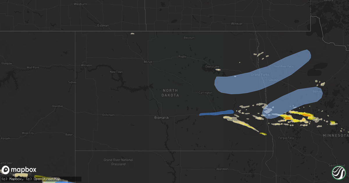
Hail Map in North Dakota on July 10, 2022
Get this storm
July 10 map
$229
one time, instant access
Download today. No call, no setup
Keep the $229
Bought the map and want the full workflow? Apply the entire $229 to a subscription within 7 days. None of it is wasted.
Every map, not just this one
This buys you this map. Subscription and you get every map we run, in the markets you choose from a few cities to whole states to nationwide. Plus real-time alerts the moment a storm fires.
Contact data
Name, contact info, occupancy, even credit band for addresses in the footprint. You go from where it hit to who to call.
Become the source they trust
Unlimited branding weather history reports on demand. You already have the documented answer ready for the property owner, and you are the one who showed up with it.
Property data and RoofTrace estimates
Pull up any address you have got, its value and the exact code rules for that jurisdiction, straight from One Click Code. Then RoofTrace estimates the squares, pitch, and roof value, priced the way you price.
Storm reports in North Dakota
North Dakota
| Date | Description |
|---|---|
| 07/10/20222:21 PM CDT | A local report indicates 1.25 inch wind near 3 SSW GALCHUTT |
| 07/10/20221:28 PM CDT | Relayed via media partner. |
| 07/10/20221:15 PM CDT | Corrects previous hail report from enderlin. Pea to quarter size hail. Time estimated. |
| 07/10/20221:14 PM CDT | A local report indicates 1.00 inch wind near 1 WNW ENDERLIN |
| 07/10/20221:00 PM CDT | Pea to quarter size hail. Time estimated. |
| 07/10/20228:11 AM CDT | Ndawn wind gust of 60mph at 10 meters. |
| 07/10/20228:05 AM CDT | Tree branches down... Relayed via facebook. Time estimated from radar. |
| 07/10/20227:59 AM CDT | At 1258 AM MDT, a severe thunderstorm was located 7 miles south of Carlyle, or 15 miles northeast of Baker, moving east at 50 mph. HAZARD...70 mph wind gusts and quarter size hail. SOURCE...Radar indicated. IMPACT...Hail damage to vehicles is expected. Expect considerable tree damage. Wind damage is also likely to mobile homes, roofs, and outbuildings. Locations impacted include... Baker and Ollie. This replaces the warning previously in effect for this area. |
| 07/10/20227:53 AM CDT | 58mph wind gust reported at the gfk airport. |
| 07/10/20227:42 AM CDT | At 1242 PM CDT, a severe thunderstorm was located over Hastings, or 15 miles south of Valley City, moving southeast at 30 mph. HAZARD...60 mph wind gusts and quarter size hail. SOURCE...Radar indicated. IMPACT...Hail damage to vehicles is expected. Expect wind damage to roofs, siding, and trees. This severe thunderstorm will be near... Kathryn around 1250 PM CDT. Little Yellowstone around 1255 PM CDT.Other locations in the path of this severe thunderstorm include Nome,Lucca and Enderlin.This includes Interstate 94 in North Dakota between mile markers 295and 316. |
| 07/10/20227:37 AM CDT | Ndawn station measured 59mph wind gust at 10 meters. |
| 07/10/20227:35 AM CDT | Rwis report of 68mph wind gust. |
| 07/10/20227:24 AM CDT | At 1224 PM CDT, a severe thunderstorm was located over West Fargo, or near Fargo, moving east at 25 mph. HAZARD...60 mph wind gusts and quarter size hail. SOURCE...Radar indicated. IMPACT...Hail damage to vehicles is expected. Expect wind damage to roofs, siding, and trees. This severe thunderstorm will be near... West Fargo and Reile's Acres around 1225 PM CDT. Fargo and Horace around 1230 PM CDT. Prairie Rose, Frontier and North River around 1235 PM CDT. Briarwood, Moorhead and Wild Rice around 1240 PM CDT.Other locations in the path of this severe thunderstorm includeDilworth and Rustad.This includes the following highways... Interstate 29 between mile markers 55 and 77. Interstate 94 in North Dakota between mile markers 337 and 352. Interstate 94 in Minnesota between mile markers 1 and 25. |
| 07/10/20227:10 AM CDT | At 1210 PM CDT, a severe thunderstorm was located over Tower City, or 15 miles east of Valley City, moving east at 35 mph. HAZARD...60 mph wind gusts and quarter size hail. SOURCE...Radar indicated. IMPACT...Hail damage to vehicles is expected. Expect wind damage to roofs, siding, and trees. This severe thunderstorm will be near... Buffalo around 1220 PM CDT. Ayr around 1225 PM CDT.Other locations in the path of this severe thunderstorm includeAbsaraka, Wheatland, Casselton and Amenia.This includes Interstate 94 in North Dakota between mile markers 301and 337. |
| 07/10/20223:33 AM CDT | At 833 AM CDT, severe thunderstorms were located along a line extending from near Shelly to near Kragnes to near Kindred, moving east at 55 mph. HAZARD...60 mph wind gusts and quarter size hail. SOURCE...Radar indicated. IMPACT...Hail damage to vehicles is expected. Expect wind damage to roofs, siding, and trees. Severe thunderstorms will be near... Lockhart and Averill around 840 AM CDT. Comstock, Wolverton and Felton around 845 AM CDT.Other locations in the path of these severe thunderstorms includeFlaming, Fertile, Hitterdal, Rindal, Barnesville, Ranum, White EarthNation and Lawndale.This includes the following highways... Interstate 29 between mile markers 42 and 68. Interstate 94 in North Dakota between mile markers 348 and 352. Interstate 94 in Minnesota between mile markers 1 and 35. |
| 07/10/20222:35 AM CDT | At 734 AM CDT, severe thunderstorms were located along a line extending from near Mandt to near Arvilla to near Sherbrooke, moving east at 55 mph. HAZARD...60 mph wind gusts and quarter size hail. SOURCE...Radar indicated. IMPACT...Hail damage to vehicles is expected. Expect wind damage to roofs, siding, and trees. Severe thunderstorms will be near... Emerado, Grand Forks AFB and Mekinock around 740 AM CDT. Portland, Mayville and Grand Forks around 750 AM CDT.Other locations in the path of these severe thunderstorms includeCashel, Mallory, East Grand Forks, Bygland, Davidson, Cummings andHillsboro.This includes Interstate 29 between mile markers 97 and 181. |
| 07/10/20221:59 AM CDT | At 658 AM CDT, a severe thunderstorm was located near Spiritwood, or 25 miles west of Valley City, moving east at 50 mph. HAZARD...60 mph wind gusts and quarter size hail. SOURCE...Radar indicated. IMPACT...Hail damage to vehicles is expected. Expect wind damage to roofs, siding, and trees. This severe thunderstorm will be near... Urbana around 705 AM CDT. Eckelson around 710 AM CDT. Sanborn around 715 AM CDT.Other locations in the path of this severe thunderstorm includeRogers and Bald Hill Dam.This includes Interstate 94 in North Dakota between mile markers 272and 307. |
| 07/10/20221:55 AM CDT | At 655 AM CDT, severe thunderstorms were located along a line extending from Edmore to 6 miles north of Pekin to Revere, moving east at 45 mph. HAZARD...60 mph wind gusts and nickel size hail. SOURCE...Radar indicated. IMPACT...Expect damage to roofs, siding, and trees. Severe thunderstorms will be near... McVille around 700 AM CDT. Hannaford and Walum around 705 AM CDT.Other locations in the path of these severe thunderstorms includeAdams, Luverne, Sibley, Logan Center, Blabon, Lankin and Pillsbury. |
| 07/10/20221:50 AM CDT | At 650 AM CDT, a severe thunderstorm was located 5 miles northwest of Spiritwood, or 7 miles northeast of Jamestown, moving east at 55 mph. HAZARD...60 mph wind gusts and quarter size hail. SOURCE...Radar indicated. IMPACT...Hail damage to vehicles is expected. Expect wind damage to roofs, siding, and trees. This severe thunderstorm will remain over mainly rural areas of southeastern Stutsman County, including the following locations... Eldridge and Sydney. |
| 07/10/202212:27 AM CDT | At 527 AM CDT, a severe thunderstorm was located 5 miles west of Hazelton, or 14 miles northwest of Linton, moving east at 55 mph. HAZARD...70 mph wind gusts and half dollar size hail. SOURCE...Radar indicated. IMPACT...Hail damage to vehicles is expected. Expect considerable tree damage. Wind damage is also likely to mobile homes, roofs, and outbuildings. This severe thunderstorm will be near... Hazelton around 530 AM CDT. Braddock around 545 AM CDT.Other locations in the path of this severe thunderstorm includeNapoleon. |
| 07/10/202212:08 AM CDT | At 508 AM CDT, a severe thunderstorm was located near Mcclusky, moving northeast at 50 mph. HAZARD...70 mph wind gusts and quarter size hail. SOURCE...Radar indicated. IMPACT...Hail damage to vehicles is expected. Expect considerable tree damage. Wind damage is also likely to mobile homes, roofs, and outbuildings. This severe thunderstorm will be near... Goodrich around 525 AM CDT. |
| 07/10/202212:01 AM CDT | At 501 AM CDT, a severe thunderstorm was located near Towner, or 19 miles west of Rugby, moving northeast at 40 mph. HAZARD...70 mph wind gusts and quarter size hail. SOURCE...Radar indicated. IMPACT...Hail damage to vehicles is expected. Expect considerable tree damage. Wind damage is also likely to mobile homes, roofs, and outbuildings. This severe thunderstorm will be near... Barton around 520 AM CDT.Other locations in the path of this severe thunderstorm includeWillow City. |
| 07/09/202211:25 PM CDT | At 424 AM CDT/324 AM MDT/, severe thunderstorms were located along a line extending from 5 miles southwest of Stanton to 8 miles northeast of New Salem to 8 miles north of Carson, moving east at 55 mph. HAZARD...Golf ball size hail and 70 mph wind gusts. SOURCE...Public. IMPACT...People and animals outdoors will be injured. Expect hail damage to roofs, siding, windows, and vehicles. Expect considerable tree damage. Wind damage is also likely to mobile homes, roofs, and outbuildings. Severe thunderstorms will be near... Mandan and Flasher around 440 AM CDT. Washburn around 445 AM CDT. Bismarck around 450 AM CDT. St. Anthony around 455 AM CDT. Wilton around 500 AM CDT. Menoken around 505 AM CDT. Sterling and Regan around 515 AM CDT.Other locations impacted by these severe thunderstorms include Mckenzie, New Johns Lake, Baldwin, Hensler, Fort Clark, Huff and Nelson Lake. |
| 07/09/202211:13 PM CDT | At 413 AM CDT, a severe thunderstorm was located near Sawyer, or 16 miles southeast of Minot, moving northeast at 55 mph. HAZARD...60 mph wind gusts and quarter size hail. SOURCE...Radar indicated. IMPACT...Hail damage to vehicles is expected. Expect wind damage to roofs, siding, and trees. This severe thunderstorm will be near... Velva around 420 AM CDT.Other locations in the path of this severe thunderstorm includeKarlsruhe, Denbigh and Towner. |
| 07/09/202210:39 PM CDT | At 338 AM CDT/238 AM MDT/, a severe thunderstorm was located 5 miles southeast of Richardton, or 19 miles west of Glen Ullin, moving east at 55 mph. HAZARD...70 mph wind gusts and quarter size hail. SOURCE...Radar indicated. IMPACT...Hail damage to vehicles is expected. Expect considerable tree damage. Wind damage is also likely to mobile homes, roofs, and outbuildings. This severe thunderstorm will be near... Hebron around 350 AM CDT. Glen Ullin around 400 AM CDT. Almont around 415 AM CDT. New Salem around 420 AM CDT. |
| 07/09/202210:28 PM CDT | At 327 AM CDT/227 AM MDT/, severe thunderstorms were located along a line extending from 6 miles west of Mckenzie Bay Recreation Area to 6 miles north of Halliday to 5 miles south of Marshall, moving northeast at 60 mph. HAZARD...70 mph wind gusts and quarter size hail. SOURCE...Radar indicated. IMPACT...Hail damage to vehicles is expected. Expect considerable tree damage. Wind damage is also likely to mobile homes, roofs, and outbuildings. Severe thunderstorms will be near... Indian Hills Recreation Area around 340 AM CDT. Golden Valley around 350 AM CDT. Zap around 355 AM CDT. Beulah and Roseglen around 400 AM CDT. Hazen around 405 AM CDT. Hazen Bay Recreation Area around 415 AM CDT. Pick City and Lake Sakakawea State Park around 420 AM CDT. Riverdale and Fort Stevenson State Park around 425 AM CDT.Other locations impacted by these severe thunderstorms include SkunkCreek Bay Recreation Area, White Shield, Twin Buttes, Deep Water Creek Recreation Area, Raub, Dakota Waters Recreation Area, and Emmet. |
| 07/09/20229:42 PM CDT | At 242 AM CDT/142 AM MDT/, severe thunderstorms were located along a line extending from 9 miles southwest of Grassy Butte to 6 miles southeast of South Fairfield to near Amidon, moving east at 55 mph. HAZARD...70 mph wind gusts and half dollar size hail. SOURCE...Radar indicated. IMPACT...Hail damage to vehicles is expected. Expect considerable tree damage. Wind damage is also likely to mobile homes, roofs, and outbuildings. Severe thunderstorms will be near... New England around 205 AM MDT. Killdeer around 220 AM MDT. Dunn Center and Marshall around 225 AM MDT. Halliday around 240 AM MDT. Dodge around 245 AM MDT.Other locations impacted by these severe thunderstorms includeFryburg, Hirschville, Schefield, Oakdale, Fairfield, Havelock, Lefor,New Hradec, and Dickinson. |
| 07/09/20228:57 PM CDT | At 156 AM MDT, severe thunderstorms were located along a line extending from 5 miles east of Grassy Butte to 4 miles north of Manning to 10 miles northwest of Dickinson, moving east at 80 mph. THESE ARE DESTRUCTIVE STORMS FOR NORTHEAST BILLINGS, SOUTH CENTRAL MCKENZIE, AND SOUTHWEST DUNN COUNTIES. HAZARD...80 mph wind gusts and quarter size hail. SOURCE...Trained weather spotters. IMPACT...Flying debris will be dangerous to those caught without shelter. Mobile homes will be heavily damaged. Expect considerable damage to roofs, windows, and vehicles. Extensive tree damage and power outages are likely. Severe thunderstorms will be near... Killdeer and Manning around 200 AM MDT. Dunn Center around 205 AM MDT. Little Missouri State Park around 215 AM MDT.Other locations impacted by these severe thunderstorms includeHirschville, Oakdale, Fairfield, and New Hradec. |
| 07/09/20228:50 PM CDT | At 150 PM CDT, a severe thunderstorm was located 7 miles south of Barrie, or 30 miles northwest of Wahpeton, moving east at 40 mph. HAZARD...60 mph wind gusts and quarter size hail. SOURCE...Radar indicated. IMPACT...Hail damage to vehicles is expected. Expect wind damage to roofs, siding, and trees. This severe thunderstorm will be near... Colfax around 210 PM CDT.Other locations in the path of this severe thunderstorm includeGalchutt, Mooreton, McCauleyville, Abercrombie, Dwight, Kent andBrushvale.This includes Interstate 29 between mile markers 17 and 43. |
| 07/09/20228:17 PM CDT | At 117 PM CDT, a severe thunderstorm was located over Enderlin, or 28 miles southeast of Valley City, moving east at 35 mph. HAZARD...Ping pong ball size hail and 60 mph wind gusts. SOURCE...Radar indicated. IMPACT...People and animals outdoors will be injured. Expect hail damage to roofs, siding, windows, and vehicles. Expect wind damage to roofs, siding, and trees. This severe thunderstorm will be near... Sheldon around 125 PM CDT. Anselm and Venlo around 130 PM CDT.Other locations in the path of this severe thunderstorm includeLeonard and Barrie. |
All States Impacted by Hail Map on July 10, 2022
Cities Impacted by Hail Map on July 10, 2022
- Padroni, CO
- Champion, NE
- Argyle, MN
- Stephen, MN
- Ayr, ND
- Buffalo, ND
- Hawley, MN
- Pelican Rapids, MN
- Detroit Lakes, MN
- Glyndon, MN
- Vergas, MN
- New York Mills, MN
- Barnesville, MN
- Perham, MN
- Audubon, MN
- Menahga, MN
- Lake Park, MN
- Sebeka, MN
- Frazee, MN
- Ponsford, MN
- Clearwater, NE
- Orchard, NE
- Valley City, ND
- Gordon, WI
- Solon Springs, WI
- Iowa, LA
- Backus, MN
- Dilworth, MN
- Moorhead, MN
- Woodville, TX
- Colfax, ND
- Barney, ND
- Hunter, ND
- Erie, ND
- Columbus Junction, IA
- Conesville, IA
- Wyola, MT
- Burwell, NE
- Moose Lake, MN
- Sturgeon Lake, MN
- Winnebago, MN
- Andover, MN
- Forest Lake, MN
- Circle Pines, MN
- Ewing, NE
- Pine River, MN
- Crosslake, MN
- Pequot Lakes, MN
- Singer, LA
- Odebolt, IA
- Ida Grove, IA
- Arthur, IA
- What Cheer, IA
- Greensburg, LA
- Grover, CO
- New Raymer, CO
- Bushnell, NE
- Neligh, NE
- Holyoke, CO
- Lance Creek, WY
- Sundance, WY
- Alva, WY
- Hulett, WY
- Lodge Grass, MT
- Bridger, MT
- Harcourt, IA
- Dayton, IA
- Ainsworth, IA
- Imperial, NE
- Piedmont, SD
- Collins, IA
- White Owl, SD
- Howes, SD
- Adams, MN
- Medina, TX
- Haxtun, CO
- Boerne, TX
- Devils Lake, ND
- Crary, ND
- Deridder, LA
- Broken Bow, NE
- Anselmo, NE
- Story City, IA
- Wells, MN
- Hartland, MN
- Aitkin, MN
- Bartlett, NE
- Zachary, LA
- Petersburg, NE
- Spalding, NE
- Albion, NE
- Merriman, NE
- Martin, SD
- Wounded Knee, SD
- Batesland, SD
- Manderson, SD
- Pine Ridge, SD
- Pitkin, LA
- Owanka, SD
- New Underwood, SD
- Puposky, MN
- Black River Falls, WI
- Merrillan, WI
- Stewart, MN
- Malcom, IA
- Montezuma, IA
- Kerrick, MN
- Kingsley, IA
- Le Mars, IA
- Merrill, IA
- Hinton, IA
- Remsen, IA
- Verdigre, NE
- Center, NE
- Winnetoon, NE
- Monroe, NE
- Platte Center, NE
- Genoa, NE
- Atkinson, NE
- Oneill, NE
- Kathryn, ND
- Spiritwood, ND
- Fingal, ND
- Ypsilanti, ND
- Sheldon, ND
- Enderlin, ND
- Sanborn, ND
- Wyndmere, ND
- Litchville, ND
- Marion, ND
- Nome, ND
- Mcleod, ND
- Leonard, ND
- Yarmouth, IA
- Mount Union, IA
- Delavan, MN
- Sugartown, LA
- Mittie, LA
- Ragley, LA
- Oakdale, LA
- Grant, LA
- Dry Creek, LA
- Longville, LA
- Newcastle, WY
- Crosby, MN
- Deweyville, TX
- Call, TX
- Onawa, IA
- Moorhead, IA
- Hammond, MT
- Broadus, MT
- Alzada, MT
- New Roads, LA
- Somerset, WI
- Stillwater, MN
- Silsbee, TX
- Kountze, TX
- Belgrade, NE
- Cedar Rapids, NE
- Saint Edward, NE
- Fullerton, NE
- Baytown, TX
- Belle Fourche, SD
- Franklinton, LA
- Quinn, SD
- Wall, SD
- Tower City, ND
- Wasta, SD
- Crosby, TX
- Georgetown, MN
- Gardner, ND
- Harwood, ND
- Fargo, ND
- Felton, MN
- Argusville, ND
- Sherburn, MN
- Vale, SD
- Newell, SD
- Union Center, SD
- Sturgis, SD
- Rapid City, SD
- Box Elder, SD
- Kadoka, SD
- Caputa, SD
- Nunn, CO
- Claxton, GA
- Oriska, ND
- Page, ND
- Clearmont, WY
- Slaughter, LA
- Ethel, LA
- Saint Xavier, MT
- Port Allen, LA
- Enders, NE
- Sherwood, ND
- Akeley, MN
- Bemidji, MN
- Ventress, LA
- Durand, WI
- Mondovi, WI
- Willow River, MN
- West Point, NE
- Watkins, IA
- Blairstown, IA
- Ogema, MN
- Metter, GA
- Buna, TX
- Arnaudville, LA
- Davenport, ND
- Mapleton, ND
- Hammond, WI
- Houlton, WI
- Marine On Saint Croix, MN
- New Richmond, WI
- Holyoke, MN
- Keswick, IA
- Sigourney, IA
- Webster, IA
- Harper, IA
- Tenstrike, MN
- Busby, MT
- Garryowen, MT
- Callaway, NE
- Starks, LA
- Rochert, MN
- Callaway, MN
- Petersburg, ND
- Grand Marais, MN
- Hines, MN
- Greeley, NE
- Scotia, NE
- Wolbach, NE
- Grafton, ND
- Osage, MN
- Park Rapids, MN
- Erwinville, LA
- Jarreau, LA
- Lakeland, LA
- Nichols, IA
- Lone Tree, IA
- Horace, ND
- Wheatland, ND
- Chelsea, IA
- Elberon, IA
- Wauneta, NE
- Craig, NE
- Oakland, NE
- Philip, SD
- Milesville, SD
- Custer, SD
- Hot Springs, SD
- Edgemont, SD
- Amite, LA
- Winfield, IA
- Crawfordsville, IA
- Washington, IA
- Olds, IA
- Mount Pleasant, IA
- Wayland, IA
- Brighton, IA
- Wapello, IA
- Morning Sun, IA
- Austin, TX
- Paoli, CO
- Amherst, CO
- Sour Lake, TX
- Elsie, NE
- Hayes Center, NE
- Madrid, NE
- Marengo, IA
- Tylertown, MS
- Boone, IA
- Ames, IA
- Gilman, IA
- Hartwick, IA
- Montour, IA
- Deep River, IA
- Parnell, IA
- Brooklyn, IA
- Tama, IA
- Wellman, IA
- North English, IA
- Guernsey, IA
- Ladora, IA
- Williamsburg, IA
- Belle Plaine, IA
- South English, IA
- Kalona, IA
- Grinnell, IA
- Victor, IA
- Fordville, ND
- West Fargo, ND
- Birney, MT
- Amana, IA
- Norway, IA
- Keota, IA
- Forest Hill, LA
- Spring, TX
- Houston, TX
- Breaux Bridge, LA
- Gothenburg, NE
- Brady, NE
- Dent, MN
- Henderson, MN
- Green Isle, MN
- Ellsworth Afb, SD
- Rothsay, MN
- Wolverton, MN
- Neillsville, WI
- Deerwood, MN
- Nisland, SD
- Spearfish, SD
- Lead, SD
- Moorcroft, WY
- Deadwood, SD
- Whitewood, SD
- Devils Tower, WY
- Weston, WY
- Aladdin, WY
- Beulah, WY
- Black Hawk, SD
- Nemo, SD
- Decatur, NE
- Tekamah, NE
- Stapleton, NE
- Arnold, NE
- Merna, NE
- Casselton, ND
- Nevis, MN
- Armstrong Creek, WI
- Argonne, WI
- Conrad, IA
- Staples, MN
- Verndale, MN
- Rose Creek, MN
- West Chester, IA
- Fairmont, MN
- Welcome, MN
- Lake City, IA
- Lake View, IA
- Gowrie, IA
- Stratford, IA
- Auburn, IA
- Breda, IA
- Rockwell City, IA
- Kiron, IA
- Farnhamville, IA
- Carroll, IA
- Wall Lake, IA
- Lohrville, IA
- Borup, MN
- Boyes, MT
- Batchelor, LA
- Morganza, LA
- Strum, WI
- Whitehall, WI
- Eleva, WI
- Independence, WI
- Osseo, WI
- Bon Wier, TX
- Sioux City, IA
- Ironton, MN
- Otter, MT
- Merryville, LA
- Granada, MN
- Rose Hill, IA
- Delta, IA
- Vanderpool, TX
- Colo, IA
- Zearing, IA
- Jewell, IA
- Melbourne, IA
- Rhodes, IA
- Marshalltown, IA
- Stanhope, IA
- McCallsburg, IA
- State Center, IA
- Roland, IA
- Saint Anthony, IA
- Clemons, IA
- Nevada, IA
- Riceville, IA
- McIntire, IA
- Lumberton, TX
- International Falls, MN
- Sterling, CO
- Newman Grove, NE
- Maywood, NE
- Jackson, LA
- Saint Francisville, LA
- Lyle, MN
- White River, SD
- Long Valley, SD
- Wanblee, SD
- Van Horne, IA
- Keystone, IA
- Luzerne, IA
- Kentwood, LA
- Midland, SD
- Dayton, TX
- Center Point, TX
- Curtis, NE
- Vidor, TX
- Stacyville, IA
- Riverside, IA
- Columbus, MT
- Enning, SD
- Amelia, NE
- Austin, MN
- Albert Lea, MN
- Decker, MT
- Elma, IA
- Taopi, MN
- Kellogg, IA
- Gilbert, IA
- Muscatine, IA
- Haverhill, IA
- Letts, IA
- Millersburg, IA
- New Boston, IL
- Fruitland, IA
- Illinois City, IL
- Scenic, SD
- Hermosa, SD
- Jamestown, ND
- Cleveland, ND
- Medina, ND
- Niagara, ND
- Manvel, ND
- Red Lake Falls, MN
- East Grand Forks, MN
- Finley, ND
- Mcville, ND
- Emerado, ND
- Thompson, ND
- Jessie, ND
- Arvilla, ND
- Mchenry, ND
- Reynolds, ND
- Grand Forks, ND
- Newfolden, MN
- New Rockford, ND
- Michigan, ND
- Sharon, ND
- Grand Forks Afb, ND
- Larimore, ND
- Middle River, MN
- Pekin, ND
- Mekinock, ND
- Hope, ND
- Warren, MN
- Thief River Falls, MN
- Warwick, ND
- Viking, MN
- Plummer, MN
- Crookston, MN
- Gatzke, MN
- Cooperstown, ND
- Brooks, MN
- Cummings, ND
- Mayville, ND
- Fisher, MN
- Northwood, ND
- Aneta, ND
- Goodridge, MN
- Lakota, ND
- Glenfield, ND
- Tolna, ND
- Hatton, ND
- Portland, ND
- Mentor, MN
- Grygla, MN
- Euclid, MN
- Saint Hilaire, MN
- Climax, MN
- Binford, ND
- Buxton, ND
- Shevlin, MN
- Solway, MN
- Ulen, MN
- Ada, MN
- Cass Lake, MN
- Lake George, MN
- Bejou, MN
- Mahnomen, MN
- Fosston, MN
- Gary, MN
- Bagley, MN
- Naytahwaush, MN
- Twin Valley, MN
- Lengby, MN
- Hitterdal, MN
- Sabin, MN
- Waubun, MN
- White Earth, MN
- Perley, MN
- Laporte, MN
- Arlington, NE
- Paton, IA
- Humphrey, NE
- Kelley, IA
- Missouri Valley, IA
- Manning, IA
- Beaver, IA
- Rogers, NE
- Earling, IA
- Lyons, NE
- Madison, NE
- Denison, IA
- Ralston, IA
- Charter Oak, IA
- Woodward, IA
- Lidderdale, IA
- Modale, IA
- Rippey, IA
- Halbur, IA
- Vail, IA
- Churdan, IA
- Hooper, NE
- Howells, NE
- Irwin, IA
- Blencoe, IA
- Glidden, IA
- Madrid, IA
- Luther, IA
- Aspinwall, IA
- Perry, IA
- Dow City, IA
- Woodbine, IA
- Linwood, NE
- Boxholm, IA
- Dedham, IA
- Scribner, NE
- Manilla, IA
- Pisgah, IA
- Little Sioux, IA
- Schuyler, NE
- Scranton, IA
- Ute, IA
- Coon Rapids, IA
- North Bend, NE
- Bagley, IA
- Jamaica, IA
- Mondamin, IA
- Nickerson, NE
- Kennard, NE
- Logan, IA
- Dunlap, IA
- Lindsay, NE
- Westside, IA
- Stanton, NE
- Dana, IA
- Defiance, IA
- Herman, NE
- Magnolia, IA
- Wisner, NE
- Creston, NE
- Fort Calhoun, NE
- Jefferson, IA
- Grand Junction, IA
- Morse Bluff, NE
- Winslow, NE
- Snyder, NE
- Panama, IA
- Columbus, NE
- Clarkson, NE
- Portsmouth, IA
- Pilot Mound, IA
- Ames, NE
- Uehling, NE
- Leigh, NE
- Ogden, IA
- Arion, IA
- Blair, NE
- Deloit, IA
- Templeton, IA
- Arcadia, IA
- Dodge, NE
- Soldier, IA
- Fremont, NE
- Persia, IA
- Walcott, ND
- Wahpeton, ND
- Hereford, CO


