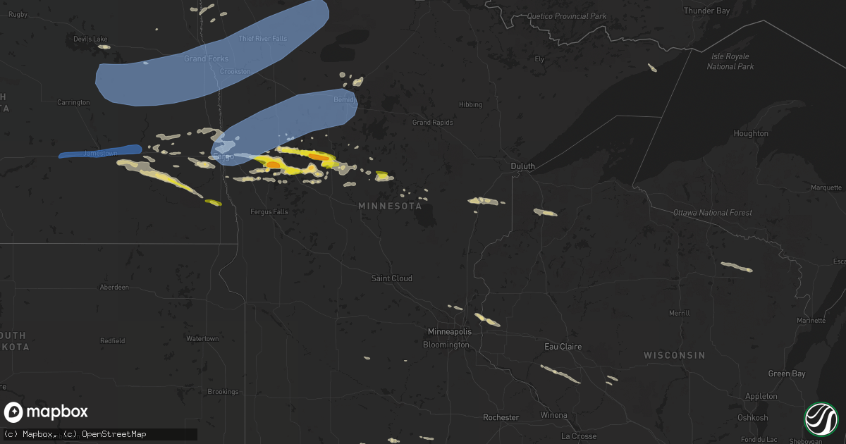
Hail Map in Minnesota on July 10, 2022
Get this storm
July 10 map
$229
one time, instant access
Download today. No call, no setup
Keep the $229
Bought the map and want the full workflow? Apply the entire $229 to a subscription within 7 days. None of it is wasted.
Every map, not just this one
This buys you this map. Subscription and you get every map we run, in the markets you choose from a few cities to whole states to nationwide. Plus real-time alerts the moment a storm fires.
Contact data
Name, contact info, occupancy, even credit band for addresses in the footprint. You go from where it hit to who to call.
Become the source they trust
Unlimited branding weather history reports on demand. You already have the documented answer ready for the property owner, and you are the one who showed up with it.
Property data and RoofTrace estimates
Pull up any address you have got, its value and the exact code rules for that jurisdiction, straight from One Click Code. Then RoofTrace estimates the squares, pitch, and roof value, priced the way you price.
Storm reports in Minnesota
Minnesota
| Date | Description |
|---|---|
| 07/10/20225:00 PM CDT | Report of tree down over a portion of highway 48 east of cloverdale. Time estimated by radar. |
| 07/10/20224:39 PM CDT | A portion of interstate 35 southbound lane was blocked by a large fallen tree. Time estimated by radar. |
| 07/10/20224:36 PM CDT | Two large spruce trees were downed with at least one uprooted. Report and photo relayed via social media. Time estimated by radar. |
| 07/10/20224:35 PM CDT | Photos sent in via social media of a cluster of trees that snapped near the trunk as well as a spruce tree that was uprooted. Time is approximated from radar. |
| 07/10/20223:18 PM CDT | Report from mping: quarter |
| 07/10/20221:45 PM CDT | Pea to quarter size hail. |
| 07/10/20221:40 PM CDT | Relayed via broadcast media partner. Time estimated via radar. |
| 07/10/20221:33 PM CDT | Relayed via broadcast media partner. |
| 07/10/20221:33 PM CDT | Relayed via broadcast media partner. |
| 07/10/20221:29 PM CDT | Relayed via broadcast media partner. |
| 07/10/20221:23 PM CDT | Estimated size from picture shared on social media. |
| 07/10/20221:18 PM CDT | Corrects previous hail report from 3 nnw cormorant. Relayed via broadcast media partner. Time estimated via radar. |
| 07/10/20221:00 PM CDT | A local report indicates 1.00 inch wind near 5 SE RICHWOOD |
| 07/10/202212:45 PM CDT | Size estimated by picture shared on social media. |
| 07/10/202211:10 AM CDT | Cass county dispatch reported a large tree down across a road south of remer. Time estimated by radar. |
| 07/10/202210:40 AM CDT | Cass county dispatch reported a power line down near hackensack. Time estimated by radar. |
| 07/10/20229:10 AM CDT | Corrects previous tstm wnd gst report from waukon. Ndawn report of 59mph wind gust. |
| 07/10/20228:33 AM CDT | Tree on house and car in newfolden. Time estimated. |
| 07/10/20228:26 AM CDT | Reported via a personal weather station. |
| 07/10/20228:19 AM CDT | Tree branches down and fence posts blown down. |
| 07/10/20228:06 AM CDT | Wind gust via personal weather station. |
| 07/10/20227:38 AM CDT | At 1237 PM CDT, a severe thunderstorm was located over Richwood, or 8 miles north of Detroit Lakes, moving east at 30 mph. HAZARD...60 mph wind gusts and quarter size hail. SOURCE...Radar indicated. IMPACT...Hail damage to vehicles is expected. Expect wind damage to roofs, siding, and trees. This severe thunderstorm will be near... Richwood around 1240 PM CDT. Detroit Lakes around 1245 PM CDT.Other locations in the path of this severe thunderstorm includeRochert, Height Of Land Lake and Toad Lake. |
| 07/10/20225:54 AM CDT | At 1051 AM CDT, severe thunderstorms were located along a line extending from near Bena, to near Longville, to near Pequot Lakes, moving east at 55 mph. HAZARD...60 mph wind gusts and quarter size hail. SOURCE...Radar indicated. IMPACT...Hail damage to vehicles is expected. Expect wind damage to roofs, siding, and trees. Severe thunderstorms will be near... Crosslake around 1100 AM CDT. Fifty Lakes, Remer and Ball Club around 1105 AM CDT. Days High Landing around 1110 AM CDT.Other locations in the path of these severe thunderstorms includeDeer River, Zemple, Hill City, Pokegama Dam, Grand Rapids, Coleraine,Taconite, Palisade, Gunn and Jacobson. |
| 07/10/20225:17 AM CDT | At 1017 AM CDT, severe thunderstorms were located along a line extending from near Bemidji, to near Akeley, to near Sebeka, moving east at 55 mph. HAZARD...60 mph wind gusts and quarter size hail. SOURCE...Radar indicated. IMPACT...Hail damage to vehicles is expected. Expect wind damage to roofs, siding, and trees. Severe thunderstorms will be near... Walker around 1025 AM CDT. Poplar around 1030 AM CDT. Leader around 1035 AM CDT.Other locations in the path of these severe thunderstorms includeWoman Lake, Longville, Leech Lake, Boy River, Gull Lake, PequotLakes, Nisswa, Breezy Point, Remer and Lake Winnibigoshish. |
| 07/10/20225:15 AM CDT | At 1015 AM CDT, severe thunderstorms were located along a line extending from Lavinia to Akeley to near Sebeka, moving east at 75 mph. HAZARD...70 mph wind gusts and quarter size hail. SOURCE...Radar indicated. IMPACT...Hail damage to vehicles is expected. Expect considerable tree damage. Wind damage is also likely to mobile homes, roofs, and outbuildings. Severe thunderstorms will be near... Pennington around 1030 AM CDT. |
| 07/10/20225:14 AM CDT | At 1013 AM CDT, severe thunderstorms were located along a line extending from Baudette, to Upper Red Lake, to 6 miles east of Lavinia, moving east at 45 mph. HAZARD...60 mph wind gusts and quarter size hail. SOURCE...Radar indicated. IMPACT...Hail damage to vehicles is expected. Expect wind damage to roofs, siding, and trees. Locations impacted include... Birchdale, Lake Winnibigoshish, Manitou, Inger, Margie and Ball Club. |
| 07/10/20225:04 AM CDT | At 1004 AM CDT, severe thunderstorms were located along a line extending from near Birch Beach to 11 miles southeast of Oaks Corner to near Wilton, moving east at 35 mph. HAZARD...60 mph wind gusts and quarter size hail. SOURCE...Radar indicated. IMPACT...Hail damage to vehicles is expected. Expect wind damage to roofs, siding, and trees. Severe thunderstorms will be near... Lavinia around 1015 AM CDT. Wheelers Point around 1020 AM CDT.Other locations in the path of these severe thunderstorms includeTurtle River and Tenstrike. |
| 07/10/20224:24 AM CDT | At 924 AM CDT, severe thunderstorms were located along a line extending from near Fosston to White Earth Nation to Lake Lida, moving east at 55 mph. HAZARD...60 mph wind gusts and quarter size hail. SOURCE...Radar indicated. IMPACT...Hail damage to vehicles is expected. Expect wind damage to roofs, siding, and trees. Severe thunderstorms will be near... Lengby, Many Point Lake and Island Lake in Mahnomen County around 930 AM CDT. Ebro, Dent and Vergas around 935 AM CDT. Pine Point, Ponsford and Richville around 940 AM CDT.Other locations in the path of these severe thunderstorms includeBagley, Perham, Shevlin and Two Inlets. |
| 07/10/20224:09 AM CDT | At 909 AM CDT, severe thunderstorms were located along a line extending from near Badger to Red Lake Nation to near McIntosh, moving east at 50 mph. HAZARD...60 mph wind gusts and quarter size hail. SOURCE...Radar indicated. IMPACT...Hail damage to vehicles is expected. Expect wind damage to roofs, siding, and trees. Severe thunderstorms will be near... Red Lake Nation around 910 AM CDT. Malung, Gully and Wannaska around 920 AM CDT. Weme, Pencer and Gonvick around 925 AM CDT.Other locations in the path of these severe thunderstorms includeClearbrook, Thorhult, Upper Red Lake and Leonard. |
| 07/10/20223:22 AM CDT | At 822 AM CDT, severe thunderstorms were located along a line extending from 6 miles west of Lake Bronson to near Carpenters Corner to Greenview, moving east at 55 mph. HAZARD...60 mph wind gusts and quarter size hail. SOURCE...Radar indicated. IMPACT...Hail damage to vehicles is expected. Expect wind damage to roofs, siding, and trees. Severe thunderstorms will be near... Harold and Carpenters Corner around 825 AM CDT. Melvin and Rosewood around 830 AM CDT. Thief River Falls, St. Hilaire and Dakota Junction around 835 AM CDT. Maple Bay, Hazel and Dugdale around 840 AM CDT.Other locations in the path of these severe thunderstorms includeMavie and Mentor. |
| 07/10/20221:16 AM CDT | At 616 AM CDT, a severe thunderstorm was located 7 miles east of Gunflint Lake, moving southeast at 30 mph. HAZARD...Ping pong ball size hail and 60 mph wind gusts. SOURCE...Radar indicated. IMPACT...People and animals outdoors will be injured. Expect hail damage to roofs, siding, windows, and vehicles. Expect wind damage to roofs, siding, and trees. This severe thunderstorm will be near... Hovland around 715 AM CDT.Other locations impacted by this severe thunderstorm include TomLake, Clearwater Lake, Bearskin Lake, Judge C. R. Magney State Park,Poplar Lake, Daniels Lake, North Lake, Judge Magney State Park, PineLake and Watab Lake. |
| 07/09/20229:15 PM CDT | At 215 PM CDT, severe thunderstorms were located along a line extending from Backus, to near Huntersville, moving east at 50 mph. HAZARD...Ping pong ball size hail and 60 mph wind gusts. SOURCE...Radar indicated. IMPACT...People and animals outdoors will be injured. Expect hail damage to roofs, siding, windows, and vehicles. Expect wind damage to roofs, siding, and trees. Severe thunderstorms will be near... Backus around 220 PM CDT.Other locations in the path of these severe thunderstorms includePine River, Emily, Outing, Pequot Lakes, Breezy Point, Crosslake andFifty Lakes. |
| 07/09/20229:08 PM CDT | At 207 PM CDT, a severe thunderstorm was located over Huntersville, or 46 miles east of Detroit Lakes, moving east at 35 mph. HAZARD...60 mph wind gusts and quarter size hail. SOURCE...Radar indicated. IMPACT...Hail damage to vehicles is expected. Expect wind damage to roofs, siding, and trees. This severe thunderstorm will be near... Badoura around 215 PM CDT. |
| 07/09/20228:56 PM CDT | At 155 PM CDT, severe thunderstorms were located along a line extending from near Hillview to near Lake Lida, moving east at 30 mph. HAZARD...Ping pong ball size hail and 60 mph wind gusts. SOURCE...Radar indicated. IMPACT...People and animals outdoors will be injured. Expect hail damage to roofs, siding, windows, and vehicles. Expect wind damage to roofs, siding, and trees. Severe thunderstorms will be near... Hillview and Midway around 200 PM CDT. Sebeka around 210 PM CDT.Other locations in the path of these severe thunderstorms includeBlue Grass, Richville, Perham and Ottertail. |
| 07/09/20228:39 PM CDT | At 139 PM CDT, a severe thunderstorm was located near Barnesville, or 23 miles southeast of Fargo, moving east at 50 mph. HAZARD...Quarter size hail. SOURCE...Radar indicated. IMPACT...Damage to vehicles is expected. This severe thunderstorm will be near... Barnesville around 140 PM CDT. Lawndale around 145 PM CDT. Rothsay around 155 PM CDT.Other locations in the path of this severe thunderstorm includePelican Rapids and Erhard.This includes Interstate 94 in Minnesota between mile markers 18 and47. |
| 07/09/20228:28 PM CDT | At 127 PM CDT, a severe thunderstorm was located over Shoreham, or near Detroit Lakes, moving southeast at 25 mph. HAZARD...60 mph wind gusts and quarter size hail. SOURCE...Radar indicated. IMPACT...Hail damage to vehicles is expected. Expect wind damage to roofs, siding, and trees. This severe thunderstorm will be near... Vergas and Frazee around 145 PM CDT.Other locations in the path of this severe thunderstorm include BigMcDonald Lake, Dent, northeastern Star Lake and Perham. |
| 07/09/20228:23 PM CDT | At 123 PM CDT, a severe thunderstorm was located near Snellman, or 23 miles east of Detroit Lakes, moving east at 30 mph. HAZARD...60 mph wind gusts and quarter size hail. SOURCE...Radar indicated. IMPACT...Hail damage to vehicles is expected. Expect wind damage to roofs, siding, and trees. This severe thunderstorm will be near... Osage around 130 PM CDT. Midway around 135 PM CDT.Other locations in the path of this severe thunderstorm includeMenahga, Park Rapids, Hubbard and Huntersville. |
All States Impacted by Hail Map on July 10, 2022
Cities Impacted by Hail Map on July 10, 2022
- Padroni, CO
- Champion, NE
- Argyle, MN
- Stephen, MN
- Ayr, ND
- Buffalo, ND
- Hawley, MN
- Pelican Rapids, MN
- Detroit Lakes, MN
- Glyndon, MN
- Vergas, MN
- New York Mills, MN
- Barnesville, MN
- Perham, MN
- Audubon, MN
- Menahga, MN
- Lake Park, MN
- Sebeka, MN
- Frazee, MN
- Ponsford, MN
- Clearwater, NE
- Orchard, NE
- Valley City, ND
- Gordon, WI
- Solon Springs, WI
- Iowa, LA
- Backus, MN
- Dilworth, MN
- Moorhead, MN
- Woodville, TX
- Colfax, ND
- Barney, ND
- Hunter, ND
- Erie, ND
- Columbus Junction, IA
- Conesville, IA
- Wyola, MT
- Burwell, NE
- Moose Lake, MN
- Sturgeon Lake, MN
- Winnebago, MN
- Andover, MN
- Forest Lake, MN
- Circle Pines, MN
- Ewing, NE
- Pine River, MN
- Crosslake, MN
- Pequot Lakes, MN
- Singer, LA
- Odebolt, IA
- Ida Grove, IA
- Arthur, IA
- What Cheer, IA
- Greensburg, LA
- Grover, CO
- New Raymer, CO
- Bushnell, NE
- Neligh, NE
- Holyoke, CO
- Lance Creek, WY
- Sundance, WY
- Alva, WY
- Hulett, WY
- Lodge Grass, MT
- Bridger, MT
- Harcourt, IA
- Dayton, IA
- Ainsworth, IA
- Imperial, NE
- Piedmont, SD
- Collins, IA
- White Owl, SD
- Howes, SD
- Adams, MN
- Medina, TX
- Haxtun, CO
- Boerne, TX
- Devils Lake, ND
- Crary, ND
- Deridder, LA
- Broken Bow, NE
- Anselmo, NE
- Story City, IA
- Wells, MN
- Hartland, MN
- Aitkin, MN
- Bartlett, NE
- Zachary, LA
- Petersburg, NE
- Spalding, NE
- Albion, NE
- Merriman, NE
- Martin, SD
- Wounded Knee, SD
- Batesland, SD
- Manderson, SD
- Pine Ridge, SD
- Pitkin, LA
- Owanka, SD
- New Underwood, SD
- Puposky, MN
- Black River Falls, WI
- Merrillan, WI
- Stewart, MN
- Malcom, IA
- Montezuma, IA
- Kerrick, MN
- Kingsley, IA
- Le Mars, IA
- Merrill, IA
- Hinton, IA
- Remsen, IA
- Verdigre, NE
- Center, NE
- Winnetoon, NE
- Monroe, NE
- Platte Center, NE
- Genoa, NE
- Atkinson, NE
- Oneill, NE
- Kathryn, ND
- Spiritwood, ND
- Fingal, ND
- Ypsilanti, ND
- Sheldon, ND
- Enderlin, ND
- Sanborn, ND
- Wyndmere, ND
- Litchville, ND
- Marion, ND
- Nome, ND
- Mcleod, ND
- Leonard, ND
- Yarmouth, IA
- Mount Union, IA
- Delavan, MN
- Sugartown, LA
- Mittie, LA
- Ragley, LA
- Oakdale, LA
- Grant, LA
- Dry Creek, LA
- Longville, LA
- Newcastle, WY
- Crosby, MN
- Deweyville, TX
- Call, TX
- Onawa, IA
- Moorhead, IA
- Hammond, MT
- Broadus, MT
- Alzada, MT
- New Roads, LA
- Somerset, WI
- Stillwater, MN
- Silsbee, TX
- Kountze, TX
- Belgrade, NE
- Cedar Rapids, NE
- Saint Edward, NE
- Fullerton, NE
- Baytown, TX
- Belle Fourche, SD
- Franklinton, LA
- Quinn, SD
- Wall, SD
- Tower City, ND
- Wasta, SD
- Crosby, TX
- Georgetown, MN
- Gardner, ND
- Harwood, ND
- Fargo, ND
- Felton, MN
- Argusville, ND
- Sherburn, MN
- Vale, SD
- Newell, SD
- Union Center, SD
- Sturgis, SD
- Rapid City, SD
- Box Elder, SD
- Kadoka, SD
- Caputa, SD
- Nunn, CO
- Claxton, GA
- Oriska, ND
- Page, ND
- Clearmont, WY
- Slaughter, LA
- Ethel, LA
- Saint Xavier, MT
- Port Allen, LA
- Enders, NE
- Sherwood, ND
- Akeley, MN
- Bemidji, MN
- Ventress, LA
- Durand, WI
- Mondovi, WI
- Willow River, MN
- West Point, NE
- Watkins, IA
- Blairstown, IA
- Ogema, MN
- Metter, GA
- Buna, TX
- Arnaudville, LA
- Davenport, ND
- Mapleton, ND
- Hammond, WI
- Houlton, WI
- Marine On Saint Croix, MN
- New Richmond, WI
- Holyoke, MN
- Keswick, IA
- Sigourney, IA
- Webster, IA
- Harper, IA
- Tenstrike, MN
- Busby, MT
- Garryowen, MT
- Callaway, NE
- Starks, LA
- Rochert, MN
- Callaway, MN
- Petersburg, ND
- Grand Marais, MN
- Hines, MN
- Greeley, NE
- Scotia, NE
- Wolbach, NE
- Grafton, ND
- Osage, MN
- Park Rapids, MN
- Erwinville, LA
- Jarreau, LA
- Lakeland, LA
- Nichols, IA
- Lone Tree, IA
- Horace, ND
- Wheatland, ND
- Chelsea, IA
- Elberon, IA
- Wauneta, NE
- Craig, NE
- Oakland, NE
- Philip, SD
- Milesville, SD
- Custer, SD
- Hot Springs, SD
- Edgemont, SD
- Amite, LA
- Winfield, IA
- Crawfordsville, IA
- Washington, IA
- Olds, IA
- Mount Pleasant, IA
- Wayland, IA
- Brighton, IA
- Wapello, IA
- Morning Sun, IA
- Austin, TX
- Paoli, CO
- Amherst, CO
- Sour Lake, TX
- Elsie, NE
- Hayes Center, NE
- Madrid, NE
- Marengo, IA
- Tylertown, MS
- Boone, IA
- Ames, IA
- Gilman, IA
- Hartwick, IA
- Montour, IA
- Deep River, IA
- Parnell, IA
- Brooklyn, IA
- Tama, IA
- Wellman, IA
- North English, IA
- Guernsey, IA
- Ladora, IA
- Williamsburg, IA
- Belle Plaine, IA
- South English, IA
- Kalona, IA
- Grinnell, IA
- Victor, IA
- Fordville, ND
- West Fargo, ND
- Birney, MT
- Amana, IA
- Norway, IA
- Keota, IA
- Forest Hill, LA
- Spring, TX
- Houston, TX
- Breaux Bridge, LA
- Gothenburg, NE
- Brady, NE
- Dent, MN
- Henderson, MN
- Green Isle, MN
- Ellsworth Afb, SD
- Rothsay, MN
- Wolverton, MN
- Neillsville, WI
- Deerwood, MN
- Nisland, SD
- Spearfish, SD
- Lead, SD
- Moorcroft, WY
- Deadwood, SD
- Whitewood, SD
- Devils Tower, WY
- Weston, WY
- Aladdin, WY
- Beulah, WY
- Black Hawk, SD
- Nemo, SD
- Decatur, NE
- Tekamah, NE
- Stapleton, NE
- Arnold, NE
- Merna, NE
- Casselton, ND
- Nevis, MN
- Armstrong Creek, WI
- Argonne, WI
- Conrad, IA
- Staples, MN
- Verndale, MN
- Rose Creek, MN
- West Chester, IA
- Fairmont, MN
- Welcome, MN
- Lake City, IA
- Lake View, IA
- Gowrie, IA
- Stratford, IA
- Auburn, IA
- Breda, IA
- Rockwell City, IA
- Kiron, IA
- Farnhamville, IA
- Carroll, IA
- Wall Lake, IA
- Lohrville, IA
- Borup, MN
- Boyes, MT
- Batchelor, LA
- Morganza, LA
- Strum, WI
- Whitehall, WI
- Eleva, WI
- Independence, WI
- Osseo, WI
- Bon Wier, TX
- Sioux City, IA
- Ironton, MN
- Otter, MT
- Merryville, LA
- Granada, MN
- Rose Hill, IA
- Delta, IA
- Vanderpool, TX
- Colo, IA
- Zearing, IA
- Jewell, IA
- Melbourne, IA
- Rhodes, IA
- Marshalltown, IA
- Stanhope, IA
- McCallsburg, IA
- State Center, IA
- Roland, IA
- Saint Anthony, IA
- Clemons, IA
- Nevada, IA
- Riceville, IA
- McIntire, IA
- Lumberton, TX
- International Falls, MN
- Sterling, CO
- Newman Grove, NE
- Maywood, NE
- Jackson, LA
- Saint Francisville, LA
- Lyle, MN
- White River, SD
- Long Valley, SD
- Wanblee, SD
- Van Horne, IA
- Keystone, IA
- Luzerne, IA
- Kentwood, LA
- Midland, SD
- Dayton, TX
- Center Point, TX
- Curtis, NE
- Vidor, TX
- Stacyville, IA
- Riverside, IA
- Columbus, MT
- Enning, SD
- Amelia, NE
- Austin, MN
- Albert Lea, MN
- Decker, MT
- Elma, IA
- Taopi, MN
- Kellogg, IA
- Gilbert, IA
- Muscatine, IA
- Haverhill, IA
- Letts, IA
- Millersburg, IA
- New Boston, IL
- Fruitland, IA
- Illinois City, IL
- Scenic, SD
- Hermosa, SD
- Jamestown, ND
- Cleveland, ND
- Medina, ND
- Niagara, ND
- Manvel, ND
- Red Lake Falls, MN
- East Grand Forks, MN
- Finley, ND
- Mcville, ND
- Emerado, ND
- Thompson, ND
- Jessie, ND
- Arvilla, ND
- Mchenry, ND
- Reynolds, ND
- Grand Forks, ND
- Newfolden, MN
- New Rockford, ND
- Michigan, ND
- Sharon, ND
- Grand Forks Afb, ND
- Larimore, ND
- Middle River, MN
- Pekin, ND
- Mekinock, ND
- Hope, ND
- Warren, MN
- Thief River Falls, MN
- Warwick, ND
- Viking, MN
- Plummer, MN
- Crookston, MN
- Gatzke, MN
- Cooperstown, ND
- Brooks, MN
- Cummings, ND
- Mayville, ND
- Fisher, MN
- Northwood, ND
- Aneta, ND
- Goodridge, MN
- Lakota, ND
- Glenfield, ND
- Tolna, ND
- Hatton, ND
- Portland, ND
- Mentor, MN
- Grygla, MN
- Euclid, MN
- Saint Hilaire, MN
- Climax, MN
- Binford, ND
- Buxton, ND
- Shevlin, MN
- Solway, MN
- Ulen, MN
- Ada, MN
- Cass Lake, MN
- Lake George, MN
- Bejou, MN
- Mahnomen, MN
- Fosston, MN
- Gary, MN
- Bagley, MN
- Naytahwaush, MN
- Twin Valley, MN
- Lengby, MN
- Hitterdal, MN
- Sabin, MN
- Waubun, MN
- White Earth, MN
- Perley, MN
- Laporte, MN
- Arlington, NE
- Paton, IA
- Humphrey, NE
- Kelley, IA
- Missouri Valley, IA
- Manning, IA
- Beaver, IA
- Rogers, NE
- Earling, IA
- Lyons, NE
- Madison, NE
- Denison, IA
- Ralston, IA
- Charter Oak, IA
- Woodward, IA
- Lidderdale, IA
- Modale, IA
- Rippey, IA
- Halbur, IA
- Vail, IA
- Churdan, IA
- Hooper, NE
- Howells, NE
- Irwin, IA
- Blencoe, IA
- Glidden, IA
- Madrid, IA
- Luther, IA
- Aspinwall, IA
- Perry, IA
- Dow City, IA
- Woodbine, IA
- Linwood, NE
- Boxholm, IA
- Dedham, IA
- Scribner, NE
- Manilla, IA
- Pisgah, IA
- Little Sioux, IA
- Schuyler, NE
- Scranton, IA
- Ute, IA
- Coon Rapids, IA
- North Bend, NE
- Bagley, IA
- Jamaica, IA
- Mondamin, IA
- Nickerson, NE
- Kennard, NE
- Logan, IA
- Dunlap, IA
- Lindsay, NE
- Westside, IA
- Stanton, NE
- Dana, IA
- Defiance, IA
- Herman, NE
- Magnolia, IA
- Wisner, NE
- Creston, NE
- Fort Calhoun, NE
- Jefferson, IA
- Grand Junction, IA
- Morse Bluff, NE
- Winslow, NE
- Snyder, NE
- Panama, IA
- Columbus, NE
- Clarkson, NE
- Portsmouth, IA
- Pilot Mound, IA
- Ames, NE
- Uehling, NE
- Leigh, NE
- Ogden, IA
- Arion, IA
- Blair, NE
- Deloit, IA
- Templeton, IA
- Arcadia, IA
- Dodge, NE
- Soldier, IA
- Fremont, NE
- Persia, IA
- Walcott, ND
- Wahpeton, ND
- Hereford, CO


