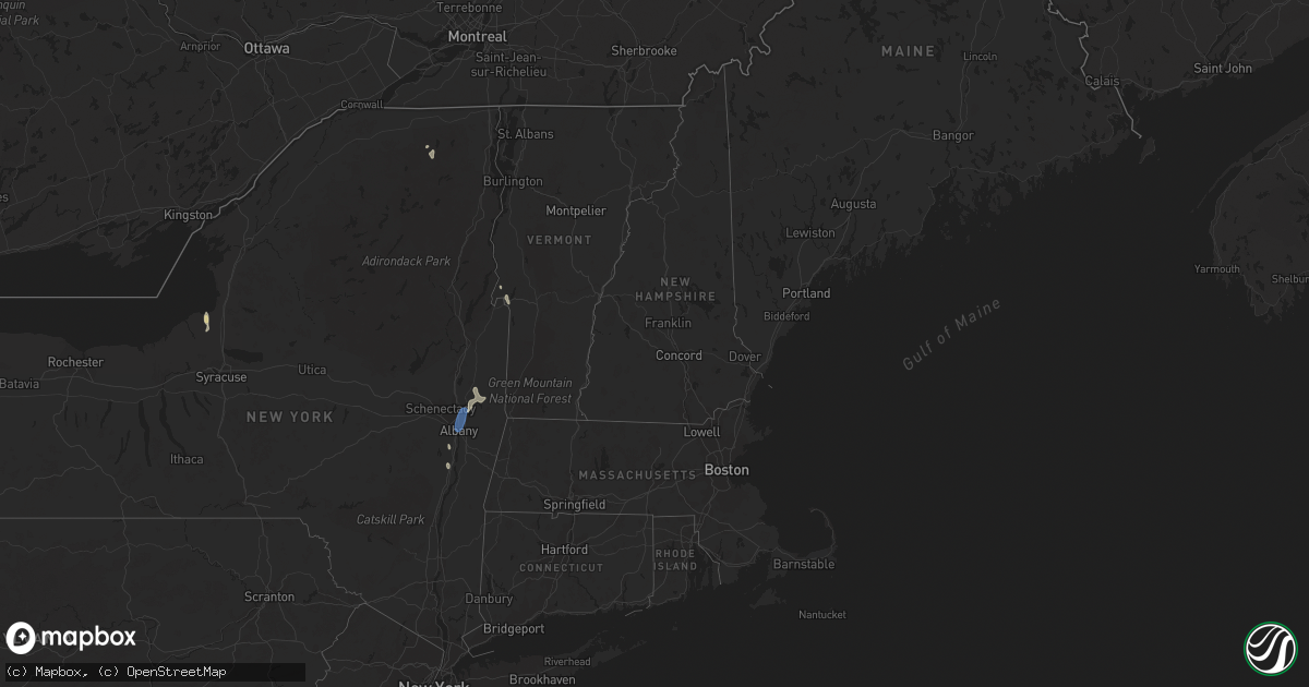
Hail Map in Vermont on July 9, 2023
Get this storm
July 9 map
$229
one time, instant access
Download today. No call, no setup
Keep the $229
Bought the map and want the full workflow? Apply the entire $229 to a subscription within 7 days. None of it is wasted.
Every map, not just this one
This buys you this map. Subscription and you get every map we run, in the markets you choose from a few cities to whole states to nationwide. Plus real-time alerts the moment a storm fires.
Contact data
Name, contact info, occupancy, even credit band for addresses in the footprint. You go from where it hit to who to call.
Become the source they trust
Unlimited branding weather history reports on demand. You already have the documented answer ready for the property owner, and you are the one who showed up with it.
Property data and RoofTrace estimates
Pull up any address you have got, its value and the exact code rules for that jurisdiction, straight from One Click Code. Then RoofTrace estimates the squares, pitch, and roof value, priced the way you price.
Storm reports in Vermont
Vermont
| Date | Description |
|---|---|
| 07/09/20234:30 PM CDT | Town social media page reports trees down in roadways blocking some roads. Time estimated from radar. |
| 07/09/20233:35 PM CDT | Trees down on side of i89 |
| 07/09/20233:09 PM CDT | Many trees down in ainsworth state park with secondary roads blocked by trees |
| 07/09/20231:04 PM CDT | Trees and branches down on jericho road in richmond |
All States Impacted by Hail Map on July 9, 2023
Cities Impacted by Hail Map on July 9, 2023
- Liberal, KS
- Kismet, KS
- Hugoton, KS
- Turpin, OK
- Forgan, OK
- Hooker, OK
- Tyrone, OK
- Guymon, OK
- Goodwell, OK
- Beaver, OK
- Plains, KS
- Meade, KS
- Gate, OK
- Laverne, OK
- Balko, OK
- Hardesty, OK
- Keyes, OK
- Texhoma, OK
- Elkhart, KS
- Gruver, TX
- Spearman, TX
- Perryton, TX
- Follett, TX
- Darrouzett, TX
- Shattuck, OK
- Booker, TX
- Miami, TX
- Higgins, TX
- Stinnett, TX
- Lipscomb, TX
- Canadian, TX
- Pampa, TX
- Arnett, OK
- Reydon, OK
- Briscoe, TX
- Durham, OK
- Crawford, OK
- Norman, OK
- Cheyenne, OK
- Wheeler, TX
- Mobeetie, TX
- Noble, OK
- McLeansville, NC
- Gibsonville, NC
- Whitsett, NC
- Burlington, NC
- Elon, NC
- Blanch, NC
- Providence, NC
- Milton, NC
- Yadkinville, NC
- East Bend, NC
- Greensboro, NC
- Kernersville, NC
- Osceola, AR
- Summerfield, NC
- Blossom, TX
- Detroit, TX
- Hagerstown, MD
- Waynesboro, PA
- Boonville, NC
- Yanceyville, NC
- Ringgold, VA
- Paris, TX
- Powderly, TX
- Snow Camp, NC
- Liberty, NC
- Graham, NC
- Arthur City, TX
- South Boston, VA
- Halifax, VA
- Pelham, NC
- Delco, NC
- Bolton, NC
- Sanford, NC
- Bear Creek, NC
- Liverpool, PA
- Rensselaer, NY
- Albany, NY
- Troy, NY
- Latham, NY
- Watervliet, NY
- Cohoes, NY
- Waterford, NY
- Barney, GA
- Adel, GA
- Hahira, GA
- Ray City, GA
- Valdosta, GA
- Hubert, NC
- Camp Lejeune, NC
- Pattison, MS
- Sterling, ND
- Richlands, NC
- Jacksonville, NC
- Melrose, NY
- Mexico, NY
- Riegelwood, NC
- West Point, MS
- Cape Charles, VA
- Fulton, NY
- Fair Haven, VT
- Poultney, VT
- Castleton, VT
- Ravena, NY
- Lillington, NC
- Coats, NC
- Owls Head, NY
- West Coxsackie, NY
- Selkirk, NY
- Columbus, MS
- Coxsackie, NY
- Climax, NY
- Johnsonville, NY
- Oberlin, LA
- Kinder, LA
- Oswego, NY
- Central Square, NY
- Bunnlevel, NC
- Schaghticoke, NY
- Valley Falls, NY
- Pillager, MN
- Motley, MN
- Cushing, MN
- Fort Ripley, MN
- Brainerd, MN
- Bagley, MN
- Shevlin, MN
- Solway, MN
- Bemidji, MN
- Laporte, MN
- Detroit Lakes, MN
- Callaway, MN
- Rochert, MN
- Frazee, MN
- Menahga, MN
- New York Mills, MN
- Delhi, LA
- De Kalb, MS
- Philadelphia, MS
- Boyce, LA
- Hermanville, MS
- Utica, MS
- Staples, MN
- Verndale, MN
- Tallulah, LA
- Leesville, LA
- Fort Polk, LA
- Pitkin, LA
- Nisswa, MN
- Pequot Lakes, MN
- Hazlehurst, MS
- Deridder, LA
- Rosepine, LA
- Brimson, MN
- Mekinock, ND
- Ponsford, MN
- Grand Rapids, MN
- Duluth, MN
- Ada, MN
- Borup, MN
- Hendrum, MN
- Clearbrook, MN
- Fosston, MN
- Roosevelt, MN
- Ulen, MN
- Embarrass, MN
- Neche, ND
- Iron, MN
- Warba, MN
- Jacobson, MN
- Swan River, MN
- Silver Bay, MN
- Finland, MN
- Warroad, MN
- Hitterdal, MN
- Manvel, ND
- Ogema, MN
- Lancaster, MN
- Harleton, TX
- Danville, PA


