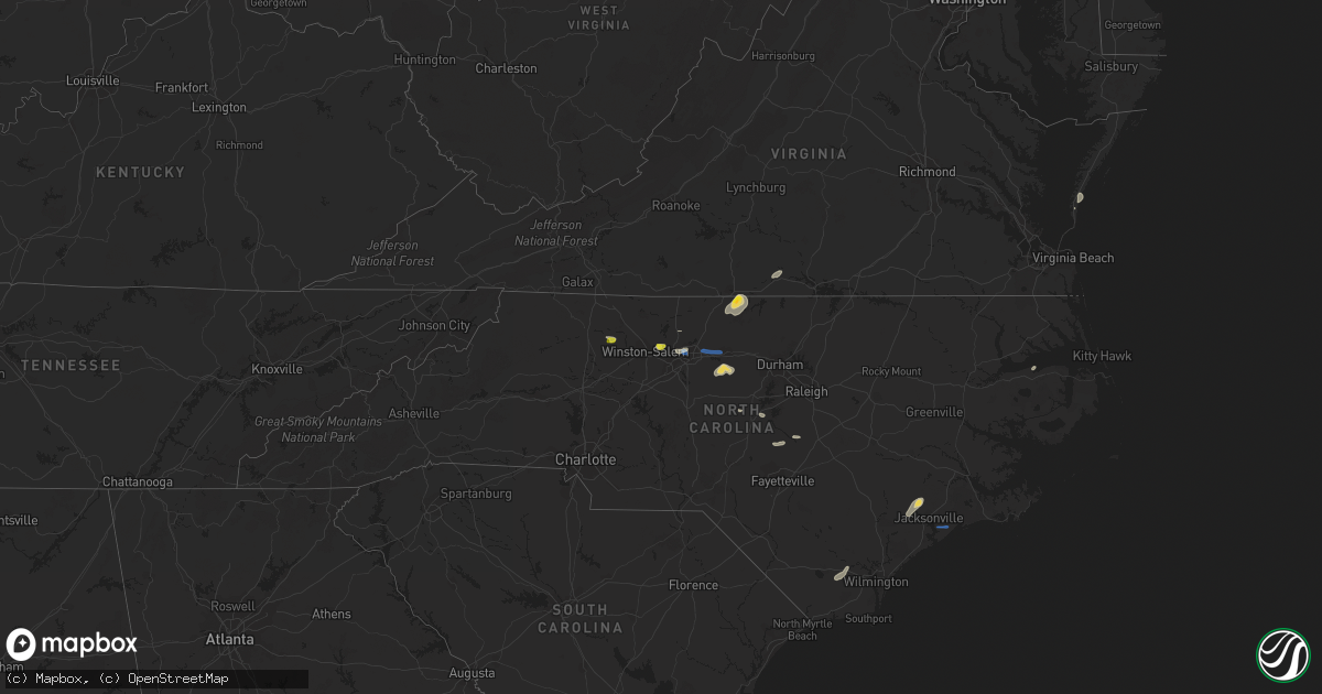
Hail Map on July 9, 2023
Get this storm
July 9 map
$229
one time, instant access
Download today. No call, no setup
Keep the $229
Bought the map and want the full workflow? Apply the entire $229 to a subscription within 7 days. None of it is wasted.
Every map, not just this one
This buys you this map. Subscription and you get every map we run, in the markets you choose from a few cities to whole states to nationwide. Plus real-time alerts the moment a storm fires.
Contact data
Name, contact info, occupancy, even credit band for addresses in the footprint. You go from where it hit to who to call.
Become the source they trust
Unlimited branding weather history reports on demand. You already have the documented answer ready for the property owner, and you are the one who showed up with it.
Property data and RoofTrace estimates
Pull up any address you have got, its value and the exact code rules for that jurisdiction, straight from One Click Code. Then RoofTrace estimates the squares, pitch, and roof value, priced the way you price.
States Impacted by Hail Map on July 9, 2023
Storm reports
New Mexico
| Date | Description |
|---|---|
| 07/09/20236:00 PM CDT | Mesonet station fw9688 jal. |
North Carolina
| Date | Description |
|---|---|
| 07/09/20234:28 PM CDT | Carteret craven electrical cooperative reports numerous power outages due to downed wires. |
| 07/09/20234:15 PM CDT | Carteret craven electical cooperative reports numerous power outages due to downed wires. |
| 07/09/20234:00 PM CDT | Public reported tree down. |
| 07/09/20233:34 PM CDT | Shingles blown off roof. Trees snapped. Spotter noted very strong winds as the storms moved through. |
| 07/09/20233:00 PM CDT | Power lines down. |
| 07/09/20232:56 PM CDT | Numerous trees of all sizes down between blanch and milton in the northeastern part of caswell county. Several roads were blocked from downed trees including blanch roa |
| 07/09/20232:56 PM CDT | Corrects previous tstm wnd dmg report from blanch. Numerous trees of all sizes down between blanch and milton in the northeastern part of caswell county. Several roads |
| 07/09/20232:56 PM CDT | Corrects previous tstm wnd dmg report from blanch. Numerous trees of all sizes down between blanch and milton in the northeastern part of caswell county. Several roads |
| 07/09/20232:54 PM CDT | Tree down blocking the road. |
| 07/09/20232:44 PM CDT | Multiple power outages reported by power company. Time estimated based on radar. |
| 07/09/20232:43 PM CDT | Multiple power outages in northern duplin county. |
| 07/09/20232:43 PM CDT | Powerline down. Time estimated based on radar. |
| 07/09/20232:43 PM CDT | Tree down near bear hole road. Time estimated based on radar. |
| 07/09/20232:41 PM CDT | Delayed report. Significant portion of a large tree was snapped off near the base. Report via facebook. Time estimated based on radar. |
| 07/09/20232:10 PM CDT | Tree down near e new hope rd and may rd. |
| 07/09/20232:05 PM CDT | Tree down. |
| 07/09/20232:05 PM CDT | Trees and power lines down resulting in power outages around ebenezer forest rd and e elizabeth st. |
| 07/09/20232:04 PM CDT | Trees and power lines down causing power outages around wayne memorial dr and w new hope rd. |
| 07/09/20232:00 PM CDT | Trees and power lines down resulting in power outages around s pineview ave and e pine st in goldsboro. |
| 07/09/20231:59 PM CDT | Trees down near linwood ave in goldsboro. |
| 07/09/20231:59 PM CDT | Jones-onslow electric membership cooperative reports numerous power outages due to wires down in the richlands area. |
| 07/09/20231:50 PM CDT | Numerous trees down around the area. |
| 07/09/20231:49 PM CDT | Trees down. |
| 07/09/20231:48 PM CDT | Several trees down around wilson. |
| 07/09/20231:48 PM CDT | Tree down. |
| 07/09/20231:48 PM CDT | Trees down along hayes mill rd. |
| 07/09/20231:19 PM CDT | Trees and power lines down resulting in power outages around hannah creek rd and us-301. |
| 07/09/20231:15 PM CDT | Tree reported down across tilghman road between red hill church rd and apple jack lane. |
| 07/09/20231:10 PM CDT | Tree down on power line at parish and augusta avenue near benson... Nc. |
| 07/09/20231:09 PM CDT | Large tree down on power lines at mills street and wake forest road in raleigh. |
| 07/09/202312:58 PM CDT | Power outages due to fallen trees on equipment. |
| 07/09/202312:52 PM CDT | Power outages due to fallen trees on power equipment. |
| 07/09/202312:47 PM CDT | Power outages due to trees falling on equipment. |
| 07/09/202312:45 PM CDT | Trees and power lines down resulting in power outages around mcdougald rd and adcock rd. |
| 07/09/202312:41 PM CDT | Power outages due to fallen trees on equipment. |
| 07/09/202312:20 PM CDT | Hundreds of power outages due to trees down on equipment. |
| 07/09/202312:07 PM CDT | Trees down on power lines near nc highway 87 and w salisbury st... Resulting in hundreds of power outages. |
| 07/09/202311:58 AM CDT | Trees down on power lines resulting in power outages around old nc-86 and old spring rd. |
| 07/09/202311:53 AM CDT | Multiple trees down on property off of eno cemetery road. |
| 07/09/202311:48 AM CDT | Multiple trees down along the lake. Some snapped... Some uprooted. |
| 07/09/202311:48 AM CDT | Tree reported down on intersection of millcreek road and lonesome road. |
| 07/09/202311:48 AM CDT | Two trees down on cedar grove and efland road. |
| 07/09/202311:43 AM CDT | Treed down on triple circle drive north of eflan. |
| 07/09/202311:37 AM CDT | Report from mping: 1-inch tree limbs broken; shingles blown off. |
| 07/09/202311:37 AM CDT | Report from mping: 1-inch tree limbs broken; shingles blown off. |
| 07/09/202311:36 AM CDT | Corrects previous tstm wnd dmg report from blanch. Numerous trees of all sizes down between blanch and milton in the northeastern part of caswell county. Several roads |
| 07/09/202311:27 AM CDT | Tree downed by thunderstorm winds on nc highway 62. |
| 07/09/202311:27 AM CDT | Tree downed by thunderstorm winds on nc highway 62. |
| 07/09/202311:24 AM CDT | Tree downed by thunderstorm winds near the intersection of longs mill road and daniel dairy road. |
| 07/09/202311:24 AM CDT | Tree downed by thunderstorm winds near the intersection of longs mill road and daniel dairy road. |
| 07/09/202311:23 AM CDT | Tree reported down on edgewood drive and eden street in burlington. |
| 07/09/202311:21 AM CDT | Tree downed by thunderstorm winds near the intersection of highway 62 and zimmerman road. |
| 07/09/202311:21 AM CDT | Tree downed by thunderstorm winds near the intersection of highway 62 and zimmerman road. |
| 07/09/202311:15 AM CDT | Tree downed by thunderstorm winds in the 3200 block of country home road. |
| 07/09/202311:15 AM CDT | Tree downed by thunderstorm winds in the 3200 block of country home road. |
| 07/09/202311:04 AM CDT | Trees down on power lines resulting in power outages near us highway 70 and springwood church rd. |
| 07/09/202310:52 AM CDT | Tree down at fuller mill rd. |
| 07/09/202310:50 AM CDT | Tree down at fairgrove rd. |
| 07/09/202310:45 AM CDT | Tree down on e holly grove rd and embler rd. |
| 07/09/202310:39 AM CDT | Several hundred power outages due to down trees on equipment. |
| 07/09/202310:36 AM CDT | Multiple large trees blocking road at intersection of onslow dr. And northampton dr. |
| 07/09/202310:33 AM CDT | Tree down on scalesville road. Time estimated from radar. |
| 07/09/202310:30 AM CDT | Tree downed by thunderstorm winds on lick fork creek road. |
| 07/09/202310:30 AM CDT | Tree downed by thunderstorm winds on lick fork creek road. |
| 07/09/202310:23 AM CDT | Several hundred power outages due to fallen trees on equipment. |
| 07/09/202310:20 AM CDT | Tree down at residence on leonard-berrier rd. |
| 07/09/202310:19 AM CDT | Tree down on mt olive church rd union grove rd. |
| 07/09/202310:06 AM CDT | A few trees down and powerlines/powerpoles down at residence in belews creek. |
| 07/09/20239:58 AM CDT | Power poles broken. Time estimated from radar. |
| 07/09/20239:58 AM CDT | Power poles broken. Time estimated from radar. |
| 07/09/20239:56 AM CDT | A tree was downed by thunderstorm winds along phillips road. |
| 07/09/20239:56 AM CDT | A tree was downed by thunderstorm winds along phillips road. |
| 07/09/20239:50 AM CDT | Several hundred power outages due to fallen trees on equipment. |
| 07/09/20239:20 AM CDT | Tree reported down on 8900 block of reynolda road. |
| 07/09/20239:17 AM CDT | Powerlines were downed by thunderstorm winds near the intersection of butner mill road and nc highway 67. |
| 07/09/20239:17 AM CDT | Powerlines were downed by thunderstorm winds near the intersection of butner mill road and nc highway 67. |
| 07/09/20239:14 AM CDT | Tree downed by thunderstorm winds near the intersection of hauser road and highway 67. |
| 07/09/20239:14 AM CDT | Tree downed by thunderstorm winds near the intersection of hauser road and highway 67. |
| 07/09/20239:03 AM CDT | Tree downed by thunderstorm winds near the intersection of indian heaps road and highway 67. |
| 07/09/20239:03 AM CDT | Tree downed by thunderstorm winds near the intersection of indian heaps road and highway 67. |
Florida
| Date | Description |
|---|---|
| 07/09/20232:05 PM CDT | A large tree was blown down along blairstone road between park ave and mahan dr. |
| 07/09/202312:07 PM CDT | Estimated 60 mph wind gusts along hastings blvd with handheld speed device. |
| 07/09/202312:01 PM CDT | Asos station kcrg jacksonvil craig. |
| 07/09/202312:00 PM CDT | Tree down on race track rd. Time estimated by radar. |
| 07/09/202311:55 AM CDT | Tree down blocking right lane on i-295s near town center exit. Time estimated by radar. |
| 07/09/202311:55 AM CDT | Tree down blocking right lane on i-295s near town ce |
| 07/09/202311:50 AM CDT | Mesonet station 1323w 1.3 se jacksonville |
| 07/09/202311:50 AM CDT | Spotter reports damage to a railroad crossing on talleyrand ave. |
| 07/09/202311:45 AM CDT | Tree down in backyard off of w 2nd st. Time estimated by radar. |
| 07/09/202311:42 AM CDT | Awos station knip jacksonville naval air station. |
| 07/09/202311:40 AM CDT | Snapped tree caused damage to a roof in duclay near blanding blvd. Time estimated by radar. |
| 07/09/202311:30 AM CDT | Awos station kvqq cecil field. |
Delaware
| Date | Description |
|---|---|
| 07/09/20235:00 PM CDT | Damage in neighborhood on the north side of middletown... De. Large neighborhood entrance sign knocked down... Trees down... And parts of roofs torn off. Report via soc |
| 07/09/20233:52 PM CDT | A survey team found additional wind damage farther northeast of where a tornadic circulation dissipated. A semi-truck was blown over on de route 1 southbound. Some corn |
| 07/09/20233:51 PM CDT | Delayed report of an over-turned tractor trailer on route 1 sb that occurred when storms passed earlier. |
| 07/09/20233:51 PM CDT | Received several photos of large trees... Tree limbs down and partial roofs ripped off of houses along hyetts corner road. Tornado possible. Time estimated via radar. |
| 07/09/20233:50 PM CDT | Emergency manager coordinator relays report of roof damage at bayberry south on rte 896. Time estimated via radar. |
| 07/09/20233:50 PM CDT | Corrects previous tstm wnd dmg report from middletown. Damage in neighborhood on the north side of middletown... De. Large neighborhood entrance sign knocked down... Tr |
| 07/09/20233:48 PM CDT | Emergency manager coordinator relays report of a roof blown off a house on choppin drive in middletown. Time estimated via radar. |
| 07/09/20233:20 PM CDT | Report of large tree limbs down on pearsons corner road in dover. Time estimated via radar. |
Georgia
| Date | Description |
|---|---|
| 07/09/20233:37 PM CDT | Tree down on a power line on overstreet road. |
| 07/09/20233:31 PM CDT | Tree down near union road and brookridge dr. |
| 07/09/20233:29 PM CDT | Tree down near highway 41 and brigman road. |
| 07/09/20233:29 PM CDT | Trees down in cecil on highway 41 and a tree across the railroad tracks in cecil at fellowship road. |
| 07/09/20233:07 PM CDT | Tree down near 400 chitty road. |
| 07/09/20233:00 PM CDT | Tree down near 1190 ione church road. |
| 07/09/20232:55 PM CDT | A couple of trees were blown down along dirt roads across northern thomas county. |
| 07/09/20232:15 PM CDT | Three trees were blown down in the cairo area. |
| 07/08/202311:56 PM CDT | Tree down along the 4400 block of old dalton road. |
Minnesota
| Date | Description |
|---|---|
| 07/09/20236:53 PM CDT | A local report indicates 1.00 inch wind near 4 E East Gull Lake |
| 07/09/20236:43 PM CDT | Photos of spikey hail. Longest axis along the spikes was 1.25 inches with a semi minor axis of about penny size. |
| 07/08/202311:26 PM CDT | Photos were received showing trees and large branches down in the area. One showed a tall white pine that was either uprooted or snapped near the base with others nearb |
| 07/08/20239:00 PM CDT | Half dollar sized hail from our co-op observer 12 e detroit lakes. |
| 07/08/20238:50 PM CDT | Relayed via facebook... Image of half dollar sized hail. |
| 07/08/20238:46 PM CDT | Report of quarter sized hail via email. |
| 07/08/20238:45 PM CDT | Broadcast media relays report of large hail in pickerel lake. |
| 07/08/20238:37 PM CDT | Quarter sized hail reported 10 s bemidji in hubbard county. |
| 07/08/20238:37 PM CDT | Quarter sized h |
| 07/08/20238:20 PM CDT | Public reports hail in becida... Around half dollar and quarter sized. |
| 07/08/20238:16 PM CDT | Public reports hail 9sw bemidji ranging in size from peas to half dollar. |
| 07/08/20238:10 PM CDT | Emergency manager relays report from public sw of solway of quarter to half dollar sized hail. |
| 07/08/20238:05 PM CDT | Public reports quarter sized hail in shevlin. |
| 07/08/20237:53 PM CDT | A local report indicates 1.50 inch wind near 8 E Motley |
| 07/08/20237:40 PM CDT | Quarter to ping pong ball sized hail reported by public east of borup. Relayed via broadcast media... Time estimated from radar. |
| 07/08/20237:38 PM CDT | Time estimated by radar. Hail was found after the storm passed. Damage to vehicles was observed. |
| 07/08/20237:38 PM CDT | A local report indicates 1.75 inch wind near 3 ESE Motley |
| 07/08/20237:38 PM CDT | Hail lasted about 3 minutes. |
| 07/08/20237:27 PM CDT | Average hail size was between nickels and quarters with the largest being quarter-sized. |
Maryland
| Date | Description |
|---|---|
| 07/09/20232:30 PM CDT | Tree down on powerlines on the 3800 block of prospect road |
| 07/09/20232:25 PM CDT | One large tree down due to thunderstorm widns at the intersection of fawn grove road and mcdermott road. |
| 07/09/20232:25 PM CDT | Tree down on the 1500 block of dooley road |
| 07/09/20232:17 PM CDT | Tree down on the 2100 block of putnam road |
| 07/09/20232:16 PM CDT | One power-line down due to thunderstorm winds along the 3000 block houcks road. |
| 07/09/20231:20 PM CDT | Multiple trees down near the 3800 block of urbana pike. |
| 07/09/202312:37 PM CDT | Tree down on benevola church road. |
New York
| Date | Description |
|---|---|
| 07/09/20235:01 PM CDT | Trees and powerlines down along 374 northwest of lyon mountain. |
| 07/09/20234:12 PM CDT | Reports of trees down between merrill and lyon mountain |
| 07/09/20232:50 PM CDT | Power lines and poles reported down near rt 67 and george thompson rd. Time estimated from radar. |
| 07/09/20232:40 PM CDT | Many branches and a few trees reported down along rt 40 south of schaghticoke. Time estimated from radar. |
| 07/09/20232:35 PM CDT | A few small trees and tree limbs reported down near washington park and the intersection of madison ave and new scotland ave. |
| 07/09/20232:25 PM CDT | Large tree and wires down on johnston rd between western ave and church rd. Time estimated from radar. |
| 07/09/20232:25 PM CDT | Public reports trees and wires down in guilderland. Time esimated from radar. |
| 07/09/20232:18 PM CDT | Meteorololgist reports multiple trees and wires down across albany... Including on n lake ave and 3rd ave. |
| 07/09/20232:05 PM CDT | Tree down on house. |
| 07/09/20231:53 PM CDT | Tree down blockig road on rt 67 and eagle bridge road in hoosick... Ny |
| 07/09/202312:05 PM CDT | Tree down on house with wires. |
Vermont
| Date | Description |
|---|---|
| 07/09/20234:30 PM CDT | Town social media page reports trees down in roadways blocking some roads. Time estimated from radar. |
| 07/09/20233:35 PM CDT | Trees down on side of i89 |
| 07/09/20233:09 PM CDT | Many trees down in ainsworth state park with secondary roads blocked by trees |
| 07/09/20231:04 PM CDT | Trees and branches down on jericho road in richmond |
Mississippi
| Date | Description |
|---|---|
| 07/09/20233:30 PM CDT | A viewer sent in a picture of a large tree down across waverly ferry rd near the intersection of wilkins-wise rd. |
West Virginia
| Date | Description |
|---|---|
| 07/09/20235:23 PM CDT | Tree down at 4447 clover dr in campbells creek area. |
| 07/09/20233:52 PM CDT | A tree has fallen and brought down power lines down with it. |
| 07/09/202312:08 PM CDT | Tree down on abbington court in hurricane. |
Pennsylvania
| Date | Description |
|---|---|
| 07/09/20236:03 PM CDT | Apple tree uprooted on buseman ave. Tree fell on home on clearview ave. Time based off the radar. |
| 07/09/20232:28 PM CDT | Trees down on wires. |
| 07/09/20231:10 PM CDT | From pema: amtrak northeast pennsylvanian train 42 is stopped east of lewistown due to large debris blocking the tracks. Per amtrak operations - pa train 42 is expectin |
| 07/09/202312:35 PM CDT | Trained spotter sent in pictures of trees down on iroquois ave near cornwall terrace elementary school that are blocking road. Time estimated via radar. |
| 07/09/202312:26 PM CDT | Road... City park and residential area flooding. |
| 07/09/202311:02 AM CDT | Tree down. |
| 07/09/202311:01 AM CDT | From pema: a garage roof blew off and struck a 1000-gallon propane tank on plum creek road in northumberland county. |
| 07/09/202310:27 AM CDT | From pema: in the area of 5124 sugar run road. In tuscarora township tree down on roadway along with a tree down on norfolk southern |
| 07/09/202310:08 AM CDT | Corrects previous report from 1 nw millerstown... Changing lsr type from tstm wind dmg to flash flood. Flooding along and over roadways. |
| 07/09/202310:08 AM CDT | Minor flooding along and on the roadways. |
| 07/09/202310:00 AM CDT | Tree across the road. |
| 07/09/20239:48 AM CDT | Trees down across route 147 near the vfw. |
| 07/09/20239:45 AM CDT | Numerous large trees down on barners church road. |
| 07/09/20239:15 AM CDT | Trees down on route 322 at mile marker 215.2. |
| 07/09/20239:12 AM CDT | Corrects previous tstm wnd dmg report from 1 s millerstown. From pema. In the area of 5124 sugar run road tree down along roadway and with a tree down on norfolk southe |
| 07/09/20238:35 AM CDT | Trees and wires down along 990 sullivan rd near benton pa. Report came in via monitoring of the columbia county 911 live feed. |
| 07/08/20239:06 PM CDT | Corrected time and location of report. Amtrak train 42 stopped east of lewistown due to large debris blocking the tracks. Debris includes fifteen trees down on the trac |
New Jersey
| Date | Description |
|---|---|
| 07/09/20232:32 PM CDT | Picture received of street flooding on cokesbury rd on border of lebanon borough and tewksbury township. |
Virginia
| Date | Description |
|---|---|
| 07/09/20231:45 PM CDT | Trees downed just off us-58 in south hill. |
| 07/09/20231:40 PM CDT | Downed tree partially blocking us-58 in boydton. |
| 07/09/202312:57 PM CDT | Numerous trees down in and around the clarksville area. |
| 07/09/202312:42 PM CDT | Trees down along nelson church rd near white house rd. |
| 07/09/202311:53 AM CDT | Tree down across denniston road. |
| 07/09/202311:41 AM CDT | Tree downed by thunderstorm winds near intersection of bouldin road and ziglar road. |
| 07/09/202311:41 AM CDT | Tree downed by thunderstorm winds near intersection of bouldin road and ziglar road. |
| 07/09/202311:34 AM CDT | Large tree limb broken off tree. |
| 07/09/202311:24 AM CDT | Large limb downed by thunderstorm winds on hamilton blvd. |
| 07/09/202311:24 AM CDT | Large limb downed by thunderstorm winds on hamilton blvd. |
Kentucky
| Date | Description |
|---|---|
| 07/09/202311:01 AM CDT | Tree down across riverside drive at 4th ave. |
South Carolina
| Date | Description |
|---|---|
| 07/09/20236:15 PM CDT | Dot reports tree down over road at 205 spring lake rd. Time estimated by radar. |
| 07/09/20236:10 PM CDT | Dot reported tree down over road near the intersection of percival rd and old percival rd. Time estimated by radar. |
| 07/09/20235:50 PM CDT | Corrects previous tstm wnd dmg report from 4 nnw harbison state forest. Social media photo from trained spotter shows a large tree limb down partially blocking the road |
| 07/09/20235:50 PM CDT | Social media photo shows a large tree limb down partially blocking the road. Time estimated by radar. |
Cities Impacted by Hail Map on July 9, 2023
- Liberal, KS
- Kismet, KS
- Hugoton, KS
- Turpin, OK
- Forgan, OK
- Hooker, OK
- Tyrone, OK
- Guymon, OK
- Goodwell, OK
- Beaver, OK
- Plains, KS
- Meade, KS
- Gate, OK
- Laverne, OK
- Balko, OK
- Hardesty, OK
- Keyes, OK
- Texhoma, OK
- Elkhart, KS
- Gruver, TX
- Spearman, TX
- Perryton, TX
- Follett, TX
- Darrouzett, TX
- Shattuck, OK
- Booker, TX
- Miami, TX
- Higgins, TX
- Stinnett, TX
- Lipscomb, TX
- Canadian, TX
- Pampa, TX
- Arnett, OK
- Reydon, OK
- Briscoe, TX
- Durham, OK
- Crawford, OK
- Norman, OK
- Cheyenne, OK
- Wheeler, TX
- Mobeetie, TX
- Noble, OK
- McLeansville, NC
- Gibsonville, NC
- Whitsett, NC
- Burlington, NC
- Elon, NC
- Blanch, NC
- Providence, NC
- Milton, NC
- Yadkinville, NC
- East Bend, NC
- Greensboro, NC
- Kernersville, NC
- Osceola, AR
- Summerfield, NC
- Blossom, TX
- Detroit, TX
- Hagerstown, MD
- Waynesboro, PA
- Boonville, NC
- Yanceyville, NC
- Ringgold, VA
- Paris, TX
- Powderly, TX
- Snow Camp, NC
- Liberty, NC
- Graham, NC
- Arthur City, TX
- South Boston, VA
- Halifax, VA
- Pelham, NC
- Delco, NC
- Bolton, NC
- Sanford, NC
- Bear Creek, NC
- Liverpool, PA
- Rensselaer, NY
- Albany, NY
- Troy, NY
- Latham, NY
- Watervliet, NY
- Cohoes, NY
- Waterford, NY
- Barney, GA
- Adel, GA
- Hahira, GA
- Ray City, GA
- Valdosta, GA
- Hubert, NC
- Camp Lejeune, NC
- Pattison, MS
- Sterling, ND
- Richlands, NC
- Jacksonville, NC
- Melrose, NY
- Mexico, NY
- Riegelwood, NC
- West Point, MS
- Cape Charles, VA
- Fulton, NY
- Fair Haven, VT
- Poultney, VT
- Castleton, VT
- Ravena, NY
- Lillington, NC
- Coats, NC
- Owls Head, NY
- West Coxsackie, NY
- Selkirk, NY
- Columbus, MS
- Coxsackie, NY
- Climax, NY
- Johnsonville, NY
- Oberlin, LA
- Kinder, LA
- Oswego, NY
- Central Square, NY
- Bunnlevel, NC
- Schaghticoke, NY
- Valley Falls, NY
- Pillager, MN
- Motley, MN
- Cushing, MN
- Fort Ripley, MN
- Brainerd, MN
- Bagley, MN
- Shevlin, MN
- Solway, MN
- Bemidji, MN
- Laporte, MN
- Detroit Lakes, MN
- Callaway, MN
- Rochert, MN
- Frazee, MN
- Menahga, MN
- New York Mills, MN
- Delhi, LA
- De Kalb, MS
- Philadelphia, MS
- Boyce, LA
- Hermanville, MS
- Utica, MS
- Staples, MN
- Verndale, MN
- Tallulah, LA
- Leesville, LA
- Fort Polk, LA
- Pitkin, LA
- Nisswa, MN
- Pequot Lakes, MN
- Hazlehurst, MS
- Deridder, LA
- Rosepine, LA
- Brimson, MN
- Mekinock, ND
- Ponsford, MN
- Grand Rapids, MN
- Duluth, MN
- Ada, MN
- Borup, MN
- Hendrum, MN
- Clearbrook, MN
- Fosston, MN
- Roosevelt, MN
- Ulen, MN
- Embarrass, MN
- Neche, ND
- Iron, MN
- Warba, MN
- Jacobson, MN
- Swan River, MN
- Silver Bay, MN
- Finland, MN
- Warroad, MN
- Hitterdal, MN
- Manvel, ND
- Ogema, MN
- Lancaster, MN
- Harleton, TX
- Danville, PA