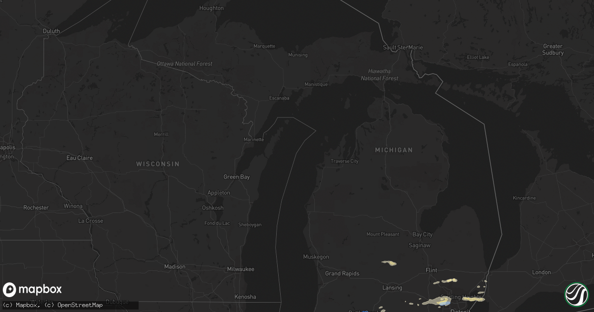
Hail Map in Michigan on July 7, 2021
Get this storm
July 7 map
$229
one time, instant access
Download today. No call, no setup
Keep the $229
Bought the map and want the full workflow? Apply the entire $229 to a subscription within 7 days. None of it is wasted.
Every map, not just this one
This buys you this map. Subscription and you get every map we run, in the markets you choose from a few cities to whole states to nationwide. Plus real-time alerts the moment a storm fires.
Contact data
Name, contact info, occupancy, even credit band for addresses in the footprint. You go from where it hit to who to call.
Become the source they trust
Unlimited branding weather history reports on demand. You already have the documented answer ready for the property owner, and you are the one who showed up with it.
Property data and RoofTrace estimates
Pull up any address you have got, its value and the exact code rules for that jurisdiction, straight from One Click Code. Then RoofTrace estimates the squares, pitch, and roof value, priced the way you price.
Storm reports in Michigan
Michigan
| Date | Description |
|---|---|
| 07/07/20214:33 PM CDT | Multiple reports of large trees and limbs down. |
| 07/07/20214:13 PM CDT | Battle creek executive airport. |
| 07/07/20214:12 PM CDT | Trees down. Table umbrella also broke. |
| 07/07/20213:58 PM CDT | Social media pictures of multiple approx 5 inch diameter tree limbs down. |
| 07/07/20213:49 PM CDT | Multiple large trees uprooted. |
| 07/07/20213:49 PM CDT | Spotter reports multiple trees down blocking roadways across the area. Some roads were impassible. |
| 07/07/20213:49 PM CDT | Social media pictures of multiple large tree limbs down in downtown farmington. |
| 07/07/20213:47 PM CDT | Multiple tree limbs downed near novi and 12 mile roads. |
| 07/07/20213:45 PM CDT | State police reporting wires down across both directions of i-275 near grand river. Some wires down on cars. |
| 07/07/20213:43 PM CDT | Reports of wires down. |
| 07/07/20213:30 PM CDT | Reports of wires down. |
| 07/07/20212:55 PM CDT | A large tree was blown down onto a house. |
| 07/07/20212:54 PM CDT | Spotter reports 8 inch diameter healthy tree limb down in middle of rock street. |
| 07/07/20212:54 PM CDT | Social media pictures of a large tree uprooted that landed on a house near masonic and harper. |
| 07/07/20212:51 PM CDT | Social media video of large tree limbs down at intersection of kelly and masonic blocking part of the road. |
| 07/07/20212:51 PM CDT | Spotter reports a few 5-6 inch diameter tree limbs down at melvin and ginley. |
| 07/07/20212:43 PM CDT | Central dispatch has recieved numerous reports of trees and wires down across southwestern livingston county. |
| 07/07/20212:18 PM CDT | Large tree limb downed near chestnut and elm streets in birmingham. |
| 07/07/20212:16 PM CDT | Numerous large tree limbs down around maple and cranbrook. |
| 07/07/20211:59 PM CDT | Social media pictures of numerous large tree limbs down in the detroit beach neighborhood. |
| 07/07/20211:49 PM CDT | State police reports multiple trees and power lines down in the groveland township area. |
| 07/07/20217:54 AM CDT | At 1254 PM EDT, a severe thunderstorm was located 8 miles east of Carson City, or 10 miles southwest of Ithaca, moving east at 25 mph. HAZARD...60 mph wind gusts and quarter size hail. SOURCE...Radar indicated. IMPACT...Hail damage to vehicles is expected. Expect wind damage to roofs, siding, and trees. Locations impacted include... Ithaca... Elsie... Eureka... North Star... Maple Rapids... Ashley... Perrinton... Pompeii... Middleton... Bannister... |
| 07/07/202112:18 AM CDT | At 518 PM EDT, a severe thunderstorm was located over Lansing, moving northeast at 20 mph. HAZARD...60 mph wind gusts and quarter size hail. SOURCE...Radar indicated. IMPACT...Hail damage to vehicles is expected. Expect wind damage to roofs, siding, and trees. Locations impacted include... Lansing... East Lansing... Edgemont Park... Waverly... Okemos... Holt... Haslett... |
| 07/07/202112:09 AM CDT | At 508 PM EDT, a severe thunderstorm was located over Detroit Zoo, or near Warren, moving east at 45 mph. HAZARD...60 mph wind gusts and penny size hail. SOURCE...Radar indicated. IMPACT...Expect damage to roofs, siding, and trees. This severe thunderstorm will be near... Warren around 515 PM EDT. St. Clair Shores around 525 PM EDT.Other locations impacted by this severe thunderstorm include CenterLine, Roseville, Clinton Township, Fraser, Utica, Eastpointe, GrossePointe Shores, Harper Woods and Grosse Pointe Woods. |
| 07/07/202112:06 AM CDT | At 506 PM EDT, a severe thunderstorm was located over Battle Creek, moving northeast at 30 mph. HAZARD...60 mph wind gusts. SOURCE...Radar indicated. IMPACT...Expect damage to roofs, siding, and trees. Locations impacted include... Battle Creek... Level Park-Oak Park... Brownlee Park... Bedford... Ceresco... |
| 07/06/202111:18 PM CDT | At 417 PM EDT, a severe thunderstorm was located near Brighton, moving east at 35 mph. HAZARD...60 mph wind gusts and quarter size hail. SOURCE...Radar indicated. IMPACT...Hail damage to vehicles is expected. Expect wind damage to roofs, siding, and trees. This severe thunderstorm will be near... South Lyon around 425 PM EDT. Milford around 430 PM EDT. Northville around 440 PM EDT. Novi around 445 PM EDT. West Bloomfield around 450 PM EDT. Southfield and Birmingham around 505 PM EDT. Troy, Royal Oak and Detroit Zoo around 510 PM EDT. Warren around 515 PM EDT.Other locations impacted by this severe thunderstorm includeFranklin, Keego Harbor, Waterford, Orchard Lake, Commerce, LathrupVillage, Auburn Hills, Bingham Farms, Lake Angelus and FarmingtonHills. |
| 07/06/202111:15 PM CDT | At 413 PM EDT, a severe thunderstorm was located near Harsens Island, or 7 miles southwest of Algonac, moving east at 40 mph. HAZARD...60 mph wind gusts and quarter size hail. SOURCE...Radar indicated. IMPACT...Hail damage to vehicles is expected. Expect wind damage to roofs, siding, and trees. This severe thunderstorm will be near... Algonac around 425 PM EDT.Other locations impacted by this severe thunderstorm includeAnchorville, Pearl Beach, Adair and Fair Haven.Additional thunderstorms may also strengthen and impact areas from Fair Haven to Marine City. |
| 07/06/202110:38 PM CDT | At 337 PM EDT, severe thunderstorms were located along a line extending from 8 miles southwest of Fowlerville to near Stockbridge to near Jackson, moving east at 35 mph. HAZARD...60 mph wind gusts and penny size hail. SOURCE...Radar indicated. IMPACT...Expect damage to roofs, siding, and trees. Severe thunderstorms will be near... Gregory around 350 PM EDT. Howell and Pinckney around 400 PM EDT. Chelsea around 405 PM EDT. Brighton, Dexter and Hamburg around 415 PM EDT. Whitmore Lake around 420 PM EDT. Ann Arbor around 425 PM EDT. South Lyon around 430 PM EDT. Salem around 435 PM EDT.Other locations impacted by these severe thunderstorms includePlainfield, Hudson Mills Metropark, Island Lake State RecreationArea, Delhi Mills, Barton Hills, Pinckney State Recreation Area,Hudson Mills, Parkers Corners, Lakeland and Lyndon Township. |
| 07/06/202110:26 PM CDT | At 322 PM EDT, a severe thunderstorm was located over Troy, moving east at 35 mph. HAZARD...60 mph wind gusts and quarter size hail. SOURCE...Radar indicated. IMPACT...Hail damage to vehicles is expected. Expect wind damage to roofs, siding, and trees. This severe thunderstorm will be near... Warren around 330 PM EDT. Sterling Heights around 335 PM EDT. Macomb Township around 340 PM EDT. St. Clair Shores and Mount Clemens around 345 PM EDT. New Baltimore around 400 PM EDT.Other locations impacted by this severe thunderstorm includeRoseville, Shelby Township, Ray Center, Fraser, Utica, Eastpointe,Washington, New Haven, Stoney Creek Metro Park and Center Line.Another severe thunderstorm will also track into the Romeo, Armada and Richmond areas over the next half hour or so. |
| 07/06/202110:10 PM CDT | At 309 PM EDT, a severe thunderstorm was located near New Baltimore, moving east at 25 mph. HAZARD...60 mph wind gusts and penny size hail. SOURCE...Radar indicated. IMPACT...Expect damage to roofs, siding, and trees. This severe thunderstorm will be near... Algonac around 320 PM EDT. St. Clair and Marine City around 325 PM EDT.Other locations impacted by this severe thunderstorm includeAnchorville, Adair, Columbus, Rattle Run, Pearl Beach, Smiths Creekand Fair Haven. |
| 07/06/20219:59 PM CDT | At 259 PM EDT, severe thunderstorms were located along a line extending from near Mason to 10 miles south of Eaton Rapids to near Burlington, moving east at 30 mph. HAZARD...60 mph wind gusts and quarter size hail. SOURCE...Radar indicated. IMPACT...Hail damage to vehicles is expected. Expect wind damage to roofs, siding, and trees. Locations impacted include... Lansing... Jackson... Albion... Mason... Eaton Rapids... East Lansing... Williamston... Leslie... Homer... Stockbridge... Brooklyn... Grass Lake... Burlington... Vandercook Lake... Leoni... Spring Arbor... Napoleon... Sandstone... Aurelius... Onondaga... |
| 07/06/20219:54 PM CDT | At 254 PM EDT, a severe thunderstorm was located over West Bloomfield, or near Novi, moving east at 25 mph. HAZARD...60 mph wind gusts and quarter size hail. SOURCE...Radar indicated. IMPACT...Hail damage to vehicles is expected. Expect wind damage to roofs, siding, and trees. This severe thunderstorm will be near... West Bloomfield around 300 PM EDT. Southfield and Birmingham around 320 PM EDT. Royal Oak and Detroit Zoo around 325 PM EDT. Troy around 330 PM EDT. Warren around 335 PM EDT. Sterling Heights around 345 PM EDT.Other locations impacted by this severe thunderstorm includeFranklin, Keego Harbor, Orchard Lake, Commerce, Lathrup Village,Bingham Farms, Farmington Hills, Pleasant Ridge, Huntington Woods andWolverine Lake. |
| 07/06/20219:47 PM CDT | At 247 PM EDT, a severe thunderstorm was located over Holly, moving east at 25 mph. HAZARD...60 mph wind gusts and quarter size hail. SOURCE...Radar indicated. IMPACT...Hail damage to vehicles is expected. Expect wind damage to roofs, siding, and trees. This severe thunderstorm will be near... Ortonville and Clarkston around 305 PM EDT. Oxford around 325 PM EDT. Almont around 345 PM EDT.Other locations impacted by this severe thunderstorm includeLakeville, Davisburg, Holly State Recreation Area, Leonard, RoseCenter, Lake Orion, Thornville, Lake Angelus, Auburn Hills andRochester Hills. |
| 07/06/20219:37 PM CDT | At 237 PM EDT, a severe thunderstorm was located 6 miles northwest of Albion, moving east at 25 mph. HAZARD...60 mph wind gusts and penny size hail. SOURCE...Radar indicated. IMPACT...Expect damage to roofs, siding, and trees. Locations impacted include... Albion... Marengo... Springport... Parma... Tompkins... |
| 07/06/20218:49 PM CDT | At 148 PM EDT, a severe thunderstorm was located over Henderson, or near Owosso, moving southeast at 25 mph. HAZARD...60 mph wind gusts and penny size hail. SOURCE...Radar indicated. IMPACT...Expect damage to roofs, siding, and trees. This severe thunderstorm will be near... Owosso around 200 PM EDT. Corunna around 210 PM EDT. Durand and Lennon around 230 PM EDT.Other locations impacted by this severe thunderstorm includeJuddville, Bennington, Carland and Vernon. |
| 07/06/20218:45 PM CDT | At 144 PM EDT, a severe thunderstorm was located near St. Johns, moving east at 20 mph. HAZARD...60 mph wind gusts and quarter size hail. SOURCE...Radar indicated. IMPACT...Hail damage to vehicles is expected. Expect wind damage to roofs, siding, and trees. Locations impacted include... St. Johns... Elsie... Ovid... |
All States Impacted by Hail Map on July 7, 2021
Cities Impacted by Hail Map on July 7, 2021
- Albion, MI
- Springport, MI
- Sarver, PA
- Edgerton, OH
- Bryan, OH
- Warren, PA
- Oxford, MI
- Leonard, MI
- New Milford, CT
- Gaylordsville, CT
- South Kent, CT
- Mansfield, OH
- Crestline, OH
- Bucyrus, OH
- Galion, OH
- Shelby, OH
- Dayton, PA
- Punxsutawney, PA
- Northpoint, PA
- Smicksburg, PA
- Sterling Heights, MI
- Warren, MI
- Harrison Township, MI
- Clinton Township, MI
- Fraser, MI
- Saint Clair Shores, MI
- Harsens Island, MI
- Roseville, MI
- Pulaski, PA
- Hillsville, PA
- Lowellville, OH
- New Wilmington, PA
- New Castle, PA
- New Middletown, OH
- Youngstown, OH
- Campbell, OH
- Edinburg, PA
- Struthers, OH
- Volant, PA
- Bessemer, PA
- Jefferson, PA
- Waynesburg, PA
- Carmichaels, PA
- Middleburgh, NY
- Lutherville Timonium, MD
- Pikesville, MD
- Towson, MD
- Baltimore, MD
- New Albany, PA
- Wyalusing, PA
- Mount Vision, NY
- New Berlin, NY
- Norwich, NY
- South New Berlin, NY
- Mount Upton, NY
- Morris, NY
- Guilford, NY
- New Lisbon, NY
- Enid, OK
- Drummond, OK
- Lahoma, OK
- Snow Shoe, PA
- Clarence, PA
- Newburg, PA
- Shippensburg, PA
- Lurgan, PA
- Orrstown, PA
- Lewistown, MT
- Tyrone, PA
- Hollidaysburg, PA
- Duncansville, PA
- East Freedom, PA
- Portage, PA
- Queen, PA
- Claysburg, PA
- Newry, PA
- Roaring Spring, PA
- Jersey, AR
- Terry, MT
- Covington, PA
- Mansfield, PA
- Mainesburg, PA
- South Weymouth, MA
- Holbrook, MA
- Braintree, MA
- Randolph, MA
- Abington, MA
- Equinunk, PA
- Long Eddy, NY
- Hankins, NY
- Hillsgrove, PA
- Williamsport, PA
- Russell, PA
- Lewis Run, PA
- Bradford, PA
- Addison, NY
- Columbia Cross Roads, PA
- Troy, PA
- Upton, WY
- Moorcroft, WY
- Sturbridge, MA
- Charlton, MA
- Southbridge, MA
- Dudley, MA
- Belmont, NY
- Almond, NY
- Angelica, NY
- Altoona, PA
- Mifflintown, PA
- Pittsburg, MO
- Smethport, PA
- Rew, PA
- Gifford, PA
- South Gibson, PA
- Susquehanna, PA
- Union Dale, PA
- Thompson, PA
- Jackson, PA
- Torrington, WY
- Canton, PA
- Berlin, PA
- Central City, PA
- Vestal, NY
- Owego, NY
- Endicott, NY
- Nichols, NY
- Johnson City, NY
- Rome, PA
- Little Meadows, PA
- Newark Valley, NY
- Apalachin, NY
- Ashland, OH
- Natrona Heights, PA
- Tarentum, PA
- Garrett, PA
- New Florence, PA
- Boswell, PA
- Ligonier, PA
- New Milford, PA
- Pond Creek, OK
- Olivet, MI
- Charlotte, MI
- Warren, MA
- Fairmont, WV
- New Kensington, PA
- Pittsburgh, PA
- Kingsley, PA
- Winchester, VA
- Benton, PA
- Osceola, PA
- New Paris, PA
- Schellsburg, PA
- New Cumberland, WV
- Forksville, PA
- Rensselaerville, NY
- Binghamton, NY
- Tariffville, CT
- Simsbury, CT
- Grass Range, MT
- Holly, MI
- Guys Mills, PA
- New Preston Marble Dale, CT
- Washington Depot, CT
- Nicholson, PA
- Saint Johns, MI
- Elsie, MI
- Ashley, MI
- Bannister, MI
- Perrinton, MI
- Franklin, NY
- Oneonta, NY
- Jefferson, OH
- Rock Creek, OH
- West Mifflin, PA
- Braddock, PA
- East Pittsburgh, PA
- Homestead, PA
- Turtle Creek, PA
- Fairhope, PA
- Nevada, MO
- Walker, MO
- Fredonia, KS
- Forsyth, MT
- Lisbon, OH
- Salineville, OH
- McAlisterville, PA
- Burnham, PA
- Oakland Mills, PA
- Yeagertown, PA
- Richfield, PA
- McClure, PA
- Lewistown, PA
- Reedsville, PA
- Butler, PA
- Saint Clair, MI
- Sullivan, OH
- Homerville, OH
- Spencer, OH
- Barkhamsted, CT
- Cayuta, NY
- Horseheads, NY
- Alum Bank, PA
- Buffalo, KS
- North Branch, NY
- Cochecton, NY
- Swan Lake, NY
- Livingston Manor, NY
- Jeffersonville, NY
- Hortonville, NY
- White Sulphur Springs, NY
- Callicoon, NY
- Damascus, PA
- Youngsville, NY
- Pleasant Hall, PA
- Roxbury, PA
- Pleasant Mount, PA
- Lakewood, PA
- Johnstown, PA
- Burgettstown, PA
- Sugarloaf, PA
- Neversink, NY
- Woodbourne, NY
- Tioga, PA
- Lawrenceville, PA
- Harrison, NE
- Edon, OH
- Montpelier, OH
- Creekside, PA
- Rural Valley, PA
- Shelocta, PA
- Northville, MI
- Lenoxville, PA
- Waymart, PA
- Hop Bottom, PA
- Herrick Center, PA
- Harford, PA
- Forest City, PA
- Roundup, MT
- Winnett, MT
- Leipsic, OH
- Sandisfield, MA
- Moore, MT
- Painted Post, NY
- Cameron Mills, NY
- Woodhull, NY
- Lindley, NY
- Apple Creek, OH
- Fredericksburg, OH
- Beaver Dams, NY
- Millport, NY
- Scio, NY
- Alfred Station, NY
- Andover, NY
- Jay Em, WY
- Red Hook, NY
- Fairmont, OK
- Covington, OK
- East Hartland, CT
- Casco, MI
- Hammond, MT
- Alzada, MT
- Boyes, MT
- Carson City, MI
- Webster, MA
- Bethel Park, PA
- Venetia, PA
- Canonsburg, PA
- Lawrence, PA
- Bridgeville, PA
- Leechburg, PA
- Milanville, PA
- Tyler Hill, PA
- Kenoza Lake, NY
- Dracut, MA
- Methuen, MA
- Pelham, NH
- Andover, MA
- Davenport, NY
- East Meredith, NY
- Beech Creek, PA
- Hannacroix, NY
- Novi, MI
- Tunkhannock, PA
- Westby, MT
- Raymond, MT
- Plentywood, MT
- Miller, SD
- Wessington, SD
- Ulster, PA
- Towanda, PA
- Wysox, PA
- Middle Bass, OH
- Put In Bay, OH
- West Pittsburg, PA
- Wampum, PA
- Campbell, NY
- Savona, NY
- Pine Valley, NY
- Hundred, WV
- New Freeport, PA
- Burton, WV
- Wassaic, NY
- Brookfield, MA
- Granville, MA
- Southwick, MA
- North Granby, CT
- Avon, MA
- Weymouth, MA
- Rockland, MA
- Deshler, OH
- Nemacolin, PA
- Greensboro, PA
- Granville Summit, PA
- Hilger, MT
- Monroeton, PA
- State College, PA
- Uniontown, PA
- Winsted, CT
- Oliveburg, PA
- Winfield, KS
- Grand Valley, PA
- Titusville, PA
- Glenshaw, PA
- Goshen, IN
- Topeka, IN
- Shipshewana, IN
- Millersburg, IN
- Kewanna, IN
- Rochester, IN
- Algonac, MI
- Fostoria, OH
- Kansas, OH
- New Philadelphia, OH
- Warrensburg, IL
- Maroa, IL
- Litchfield, OH
- Grafton, OH
- Hollsopple, PA
- Cheyenne, OK
- Philipsburg, PA
- Farmington, MI
- Huntingdon, PA
- Ellenville, NY
- Napanoch, NY
- Grahamsville, NY
- Lower Brule, SD
- Kingston, NY
- Cottekill, NY
- Hurley, NY
- Petersburg, PA
- Walled Lake, MI
- South Lyon, MI
- Wixom, MI
- West Bloomfield, MI
- Summit, NY
- Richmondville, NY
- Fultonham, NY
- Warnerville, NY
- Schoharie, NY
- Weston, OH
- Osceola, MO
- Marysville, OH
- Raymond, OH
- Claryville, NY
- Coeymans Hollow, NY
- Westerlo, NY
- Greenville, NY
- McDonald, PA
- Great Barrington, MA
- Sheffield, MA
- Nelson, PA
- Knoxville, PA
- Jasper, NY
- Middlebury Center, PA
- Elkland, PA
- Fenelton, PA
- Chicora, PA
- Saugerties, NY
- North Grosvenordale, CT
- Monroeville, IN
- Cecil, OH
- Sherwood, OH
- Defiance, OH
- Lisle, NY
- Berkshire, NY
- Galeton, PA
- Hudson, NY
- Cocolamus, PA
- Lucas, OH
- Bellville, OH
- Youngsville, PA
- Sugar Grove, PA
- Factoryville, PA
- Woodburn, IN
- Harlan, IN
- Antwerp, OH
- New Haven, IN
- Orrville, OH
- Dalton, OH
- Coventry, CT
- Columbia, CT
- Montoursville, PA
- Powell, OH
- Ostrander, OH
- Delaware, OH
- Dorset, OH
- Andover, OH
- Howell, MI
- Douglas, MA
- Zortman, MT
- Roy, MT
- Berne, NY
- Marion, OH
- Evans, WA
- Otego, NY
- Unadilla, NY
- Rileyville, VA
- Luray, VA
- Caledonia, OH
- Centerville, PA
- Tidioute, PA
- Coxsackie, NY
- Athens, NY
- Catskill, NY
- McComb, OH
- Custar, OH
- Hoytville, OH
- Holliston, MA
- Staunton, VA
- Bellwood, PA
- Valley City, OH
- Brunswick, OH
- Townville, PA
- Davis, WV
- Linesville, PA
- Uxbridge, MA
- Normantown, WV
- Glenville, WV
- Cedarville, WV
- Knox, IN
- Bloomville, NY
- West Mansfield, OH
- Hyde Park, NY
- Poughkeepsie, NY
- Highland, NY
- Rome, OH
- Prompton, PA
- Honesdale, PA
- Hammon, OK
- The Colony, TX
- Feura Bush, NY
- Climax, NY
- West Coxsackie, NY
- Alcove, NY
- Clarksville, NY
- Selkirk, NY
- Delmar, NY
- East Berne, NY
- Ravena, NY
- Bellefonte, PA
- Allison Park, PA
- Verona, PA
- Medford, OK
- Kremlin, OK
- Nash, OK
- Kitzmiller, MD
- Pinckney, MI
- Olivebridge, NY
- Frenchville, PA
- East Granby, CT
- West Granby, CT
- Granby, CT
- West Hartland, CT
- Riverton, CT
- Colebrook, CT
- West Suffield, CT
- Warren Center, PA
- Brackney, PA
- Pawling, NY
- Wingdale, NY
- Sherman, CT
- Stone Ridge, NY
- Springville, PA
- Montrose, PA
- Cairnbrook, PA
- East China, MI
- Brimfield, MA
- Corry, PA
- Columbus, PA
- Osterburg, PA
- Mount Storm, WV
- Elk Garden, WV
- Dansville, MI
- Broadway, VA
- Stockbridge, MI
- Gregory, MI
- Mark Center, OH
- Hicksville, OH
- Lanse, PA
- Millerstown, PA
- Stuyvesant, NY
- Stuyvesant Falls, NY
- Ghent, NY
- Kinderhook, NY
- Earlton, NY
- Morgantown, WV
- Pursglove, WV
- Cedar Vale, KS
- Lumberton, NC
- Cuddy, PA
- Cecil, PA
- Cabot, PA
- Saxonburg, PA
- Parksville, NY
- Loch Sheldrake, NY
- Liberty, NY
- Ferndale, NY
- Hurleyville, NY
- Timberville, VA
- Bronson, KS
- Lake Lynn, PA
- Point Marion, PA
- Maidsville, WV
- Linn, WV
- Alum Bridge, WV
- Muncy Valley, PA
- Carbondale, PA
- Mount Blanchard, OH
- Carey, OH
- Vanlue, OH
- Wharton, OH
- Fairview, OK
- Franklin, MI
- Milford, MI
- Hamburg, MI
- Brighton, MI
- Southfield, MI
- Whitmore Lake, MI
- Bloomfield Hills, MI
- Commerce Township, MI
- New Hudson, MI
- Livonia, MI
- Davenport, IA
- Walcott, IA
- Kittanning, PA
- Candor, NY
- Lagrange, OH
- Wellington, OH
- Medina, OH
- Imler, PA
- Maurertown, VA
- Nevada, OH
- Harrisville, PA
- West Oneonta, NY
- Celina, OH
- Mendon, OH
- Cross Junction, VA
- Longton, KS
- Elk City, KS
- Jermyn, PA
- Olyphant, PA
- Warsaw, MO
- Lincoln, MO
- Slippery Rock, PA
- Tipton, PA
- Port Matilda, PA
- Bridgeport, OH
- New Bethlehem, PA
- Whitney Point, NY
- Smithville Flats, NY
- Greene, NY
- Hancock, NY
- Stone Creek, OH
- Fresno, OH
- Dexter, KS
- Millville, PA
- Ringgold, PA
- Worthville, PA
- Mayport, PA
- Sprankle Mills, PA
- Roscoe, NY
- Fremont Center, NY
- Staatsburg, NY
- Dallas, PA
- Mercer, PA
- Fredonia, PA
- Sugar Run, PA
- Millersburg, OH
- Mount Morris, PA
- Ortonville, MI
- Kerhonkson, NY
- Accord, NY
- West Shokan, NY
- Irvine, PA
- Pittsfield, PA
- Chesterton, IN
- Westville, IN
- Shiloh, OH
- Noxen, PA
- Mineral Point, PA
- Parkhill, PA
- Independence, OH
- Cleveland, OH
- Stoughton, MA
- East Weymouth, MA
- Quincy, MA
- Dedham, MA
- Milton, MA
- Westwood, MA
- Norwood, MA
- Dover, MA
- Canton, MA
- Eldridge, IA
- Windsor, CT
- Windsor Locks, CT
- Rosedale, WV
- Gassaway, WV
- Culver, IN
- Hamilton, PA
- Milroy, PA
- Bowling Green, OH
- Lawrence, MA
- Laurens, NY
- New Salem, PA
- Ware, MA
- West Brookfield, MA
- West Warren, MA
- Colchester, CT
- Lebanon, CT
- South Park, PA
- Carnegie, PA
- Eighty Four, PA
- Presto, PA
- Morgan, PA
- Finleyville, PA
- Oakdale, PA
- Oldtown, MD
- Flintstone, MD
- Hysham, MT
- Friedens, PA
- Spruce Creek, PA
- Warriors Mark, PA
- Howard, PA
- Mill Hall, PA
- Sandy Ridge, PA
- Blanchard, PA
- Osceola Mills, PA
- Lock Haven, PA
- Karthaus, PA
- Julian, PA
- Morris, PA
- Gaines, PA
- Wellsboro, PA
- Loyalhanna, PA
- Blairsville, PA
- Robinson, PA
- Bolivar, PA
- Bradenville, PA
- Latrobe, PA
- Derry, PA
- Afton, NY
- Shunk, PA
- Bainbridge, NY
- Oxford, NY
- Port Crane, NY
- Castle Creek, NY
- Chenango Forks, NY
- Harpursville, NY
- Glen Aubrey, NY
- Le Raysville, PA
- Maine, NY
- Muncy, PA
- Canton, CT
- Wethersfield, CT
- East Hartford, CT
- Glastonbury, CT
- Burlington, CT
- West Hartford, CT
- Hartford, CT
- Avon, CT
- Farmington, CT
- Suffield, CT
- Tolland, CT
- South Windsor, CT
- Bloomfield, CT
- Ellington, CT
- Broad Brook, CT
- West Simsbury, CT
- Enfield, CT
- East Windsor, CT
- Stafford Springs, CT
- Somers, CT
- Belgrade, MT
- Bozeman, MT
- Garryowen, MT
- Billings, MT
- Saint Xavier, MT
- Laurel, MT
- Broadview, MT
- Big Timber, MT
- Acton, MT
- Busby, MT
- Hardin, MT
- Ryegate, MT
- Rapelje, MT
- Ballantine, MT
- Huntley, MT
- Molt, MT
- Crow Agency, MT
- Pompeys Pillar, MT
- Lodge Grass, MT
- Lavina, MT
- Rosebud, MT
- Powderville, MT
- Ismay, MT
- Volborg, MT
- Biddle, MT
- Ekalaka, MT
- Philmont, NY
- Hillsdale, NY
- Housatonic, MA
- New Baltimore, NY
- South Egremont, MA
- Chatham, NY
- Valatie, NY
- West Stockbridge, MA
- Coeymans, NY
- Schodack Landing, NY
- South Kortright, NY
- Stamford, NY
- Harpersfield, NY
- Hobart, NY
- Jefferson, NY
- North Blenheim, NY
- West Fulton, NY
- Pine City, NY
- Corning, NY
- Pine Ridge, SD
- Hingham, MA
- Williamsburg, PA
- Apollo, PA
- Vandergrift, PA
- McDonough, NY
- Beach City, OH
- Wilmot, OH
- Dundee, OH
- Cygnet, OH
- North Baltimore, OH
- Rudolph, OH
- Toronto, OH
- Steubenville, OH
- Van Tassell, WY
- Lusk, WY
- Merriman, NE
- Battle Creek, MI


