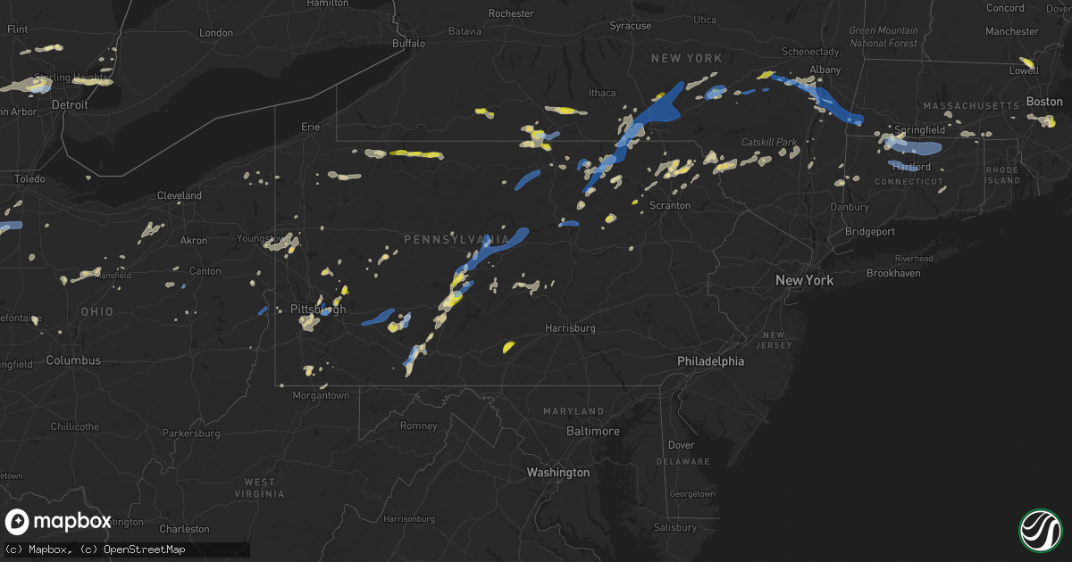
Hail Map in Pennsylvania on July 7, 2021
Get this storm
July 7 map
$229
one time, instant access
Download today. No call, no setup
Keep the $229
Bought the map and want the full workflow? Apply the entire $229 to a subscription within 7 days. None of it is wasted.
Every map, not just this one
This buys you this map. Subscription and you get every map we run, in the markets you choose from a few cities to whole states to nationwide. Plus real-time alerts the moment a storm fires.
Contact data
Name, contact info, occupancy, even credit band for addresses in the footprint. You go from where it hit to who to call.
Become the source they trust
Unlimited branding weather history reports on demand. You already have the documented answer ready for the property owner, and you are the one who showed up with it.
Property data and RoofTrace estimates
Pull up any address you have got, its value and the exact code rules for that jurisdiction, straight from One Click Code. Then RoofTrace estimates the squares, pitch, and roof value, priced the way you price.
Storm reports in Pennsylvania
Pennsylvania
| Date | Description |
|---|---|
| 07/07/20216:55 PM CDT | Multiple trees down along and near railroad track west of ore docks road. |
| 07/07/20216:50 PM CDT | Report of garrison ridge road closed due to downed telephone poles. Time estimated based on radar. |
| 07/07/20216:47 PM CDT | Report from mping: 3-inch tree limbs broken; power polesbroken. |
| 07/07/20216:47 PM CDT | Report of tree blocking roadway. Time estimated based on radar. |
| 07/07/20216:40 PM CDT | Report of downed tree blocking haines hallow road. Time estimated based on radar. |
| 07/07/20216:40 PM CDT | Multiple telephone poles downed along garrison ridge road. |
| 07/07/20216:39 PM CDT | Trees down on wires. |
| 07/07/20216:37 PM CDT | Trees and wires down. |
| 07/07/20216:35 PM CDT | A tree is reported down and blocking the road on haines hollow road. |
| 07/07/20216:31 PM CDT | Power poles down near selinsgrove. |
| 07/07/20216:28 PM CDT | Trees are reported down across 4th and county streets. |
| 07/07/20216:20 PM CDT | Report of tree down on vehicle along with poles and power lines. Time estimated based on radar. |
| 07/07/20215:59 PM CDT | Report from mping: 1-inch tree limbs broken; shinglesblown off. |
| 07/07/20215:58 PM CDT | Numerous trees down along and across coleville road. |
| 07/07/20215:55 PM CDT | Large tree across blanchard street blocking traffic. |
| 07/07/20215:55 PM CDT | Numerous trees and wires down in pleasant gap. |
| 07/07/20215:50 PM CDT | Report from mping: 3-inch tree limbs broken; power polesbroken. |
| 07/07/20215:48 PM CDT | Road closure due to trees down along morgantown road |
| 07/07/20215:45 PM CDT | Report from mping: 3-inch tree limbs broken; power polesbroken. |
| 07/07/20215:30 PM CDT | A local report indicates 1.00 inch wind near CORYVILLE |
| 07/07/20215:30 PM CDT | Large tree down on wires on east oak street. |
| 07/07/20215:21 PM CDT | Tree down on church run rd. |
| 07/07/20215:20 PM CDT | Trees uprooted in lurgan... Pa. Report from facebook. |
| 07/07/20215:15 PM CDT | Large tree branch snapped on south creek road in girard township. |
| 07/07/20215:15 PM CDT | Multiple trees down on wires. |
| 07/07/20215:14 PM CDT | 10 to 12 inch diameter... 30 to 40 ft tall tree came down near the intersection of smith rd and tow hill rd. |
| 07/07/20215:10 PM CDT | Multiple trees down on wires. |
| 07/07/20215:08 PM CDT | Corrects previous tstm wnd dmg report from 2 nw cranesville. Multiple trees down along and near railroad track west of ore docks road. |
| 07/07/20215:00 PM CDT | Multiple trees and wires down. |
| 07/07/20214:55 PM CDT | A local report indicates 1.00 inch wind near 3 NNW CYCLONE |
| 07/07/20214:54 PM CDT | Trees down on wires north of lewis run. |
| 07/07/20214:51 PM CDT | Tree down. |
| 07/07/20214:50 PM CDT | Tree down. |
| 07/07/20214:45 PM CDT | Trees and wires down on south 4th street. Time based off of radar. |
| 07/07/20214:45 PM CDT | Trees and wires down with structural damage on stewartstreet. |
| 07/07/20214:40 PM CDT | Trees and power lines down; road closure at us 322 |
| 07/07/20214:39 PM CDT | Trees down on wires. |
| 07/07/20214:39 PM CDT | Aluminum flag pole snapped in half. Report from twitter. |
| 07/07/20214:32 PM CDT | Power poles and wires down across bates street. |
| 07/07/20214:28 PM CDT | Trees and power lines down |
| 07/07/20214:22 PM CDT | Trees and power lines down around county |
| 07/07/20214:15 PM CDT | Tree down on river rd and main street. Time estimated by radar. |
| 07/07/20214:14 PM CDT | Utilty lines down |
| 07/07/20214:13 PM CDT | Power lines down in clarion borough |
| 07/07/20214:08 PM CDT | Trees and power lines down across county |
| 07/07/20214:03 PM CDT | Several trees down county wide. |
| 07/07/20214:00 PM CDT | Trees down in new bethlehem |
| 07/07/20213:58 PM CDT | Trees down on wires near schellsburg. |
| 07/07/20213:48 PM CDT | Trees and wires down on woodland street. |
| 07/07/20213:46 PM CDT | Trees down on wires. |
| 07/07/20213:44 PM CDT | Trees down on wires. |
| 07/07/20213:42 PM CDT | Large tree limbs/branches down |
| 07/07/20213:41 PM CDT | Report of numerous snapped large tree branches. Time estimated based on radar. |
| 07/07/20213:40 PM CDT | Multiple trees down. |
| 07/07/20213:36 PM CDT | Powerlines down |
| 07/07/20213:32 PM CDT | Trees down on wires on glades pike. |
| 07/07/20213:31 PM CDT | Trees down in new castle |
| 07/07/20213:30 PM CDT | Corrects previous tstm wnd dmg report from lorain.multiple trees down. |
| 07/07/20213:28 PM CDT | Widespread trees and wires down around westmont andelim. |
| 07/07/20213:15 PM CDT | Uodated report showed baldwin street was flooded and caused 4 homes to be evacuated on baldwin street and mclaughlin run road. |
| 07/07/20213:15 PM CDT | 3-inch tree limbs broken; power poles broken. |
| 07/07/20213:10 PM CDT | Trees down on mckean |
| 07/07/20213:03 PM CDT | Several vehicles stuck in high water in the area of thompson run rd and rodi road in wilkins township. |
| 07/07/20213:03 PM CDT | Roof damage to home on mushrush rd |
| 07/07/20213:02 PM CDT | Large tree limbs/branches down |
| 07/07/20212:56 PM CDT | Trees snapped or uprooted |
| 07/07/20212:54 PM CDT | Trees down on vehicle in shaler |
| 07/07/20212:54 PM CDT | Trees down in natrona heights |
| 07/07/20212:49 PM CDT | Trees and poles down |
| 07/07/20212:49 PM CDT | Report and images of snapped trees along puckert church road. Time estimated based on radar. |
| 07/07/20212:49 PM CDT | Trees down |
| 07/07/20212:49 PM CDT | Quarter-sized hail observed based on twitter video from leechburg |
| 07/07/20212:45 PM CDT | 2 airplanes overturned at butler airport |
| 07/07/20212:37 PM CDT | Shingles blown off structure and tree limbs down. |
| 07/07/20212:35 PM CDT | Shingles blown off structure and tree limbs down. |
| 07/07/20212:35 PM CDT | Large tree down along west swissvale avenue. |
| 07/07/20212:25 PM CDT | Report of numerous trees down and power outages. Time estimated based on radar. |
| 07/07/20212:16 PM CDT | Trees down in swissvale |
| 07/07/20212:15 PM CDT | State of emergency declared for edgewood boro due to thunderstorm wind damage. Time estimated based on radar. |
| 07/07/20212:15 PM CDT | Trees down along morganza road |
| 07/07/20212:15 PM CDT | Trees down in regent square |
| 07/07/20212:10 PM CDT | Trees down and power out |
| 07/07/20215:29 AM CDT | At 1028 PM EDT, severe thunderstorms were located along a line extending from near Roscoe to Glendale, moving southeast at 25 mph. HAZARD...60 mph wind gusts and quarter size hail. SOURCE...Radar indicated. IMPACT...Hail damage to vehicles is expected. Expect wind damage to roofs, siding, and trees. Locations impacted include... Rockland, Scranton, Dunmore, Fallsburg, Carbondale, Old Forge, Bushkill, Archbald, Monticello and Blakely. |
| 07/07/20214:16 AM CDT | At 915 PM EDT, a severe thunderstorm was located over Loretto, moving northeast at 40 mph. HAZARD...60 mph wind gusts. SOURCE...Law enforcement has reported numerous trees down in the path of this storm. IMPACT...Expect damage to roofs, siding, and trees. Locations impacted include... Altoona, Tyrone, Ebensburg, Bald Eagle, Bellwood, Patton, Cresson, Gallitzin, Loretto, Tipton, Carrolltown, Sankertown, Blandburg, Prince Gallitzin State Park, Horseshoe Curve, Colver, Tunnelhill, Ashville, Chest Springs and Penn State Altoona.This includes Interstate 99 from mile markers 39 to 53. |
| 07/07/20213:50 AM CDT | At 850 PM EDT, severe thunderstorms were located along a line extending from near Mansfield to Rohrsburg, moving east at 50 mph. HAZARD...60 mph wind gusts and quarter size hail. SOURCE...Radar indicated. IMPACT...Hail damage to vehicles is expected. Expect wind damage to roofs, siding, and trees. Locations impacted include... Wilkes-Barre, Falls, Muhlenberg, Kingston, Nanticoke, Plains, Pittston, Plymouth, Exeter and Vernon. |
| 07/07/20213:47 AM CDT | At 846 PM EDT, severe thunderstorms were located along a line extending from near Shunk to near Lincoln Falls to near Biggertown to near Waller to near Eyers Grove, moving east at 45 mph. HAZARD...70 mph wind gusts and quarter size hail. SOURCE...Radar indicated. IMPACT...Hail damage to vehicles is expected. Expect considerable tree damage. Wind damage is also likely to mobile homes, roofs, and outbuildings. Severe thunderstorms will be near... Rohrsburg, Jamison City, Central and Waller around 850 PM EDT. Ricketts Glen State Park around 900 PM EDT.Other locations impacted by these severe thunderstorms includeLaporte, Eagles Mere, Orangeville, Dushore, Benton, Stillwater andForksville. |
| 07/07/20213:41 AM CDT | At 841 PM EDT, a severe thunderstorm was located 7 miles northwest of Westmont, moving northeast at 35 mph. HAZARD...Wind gusts to 60 mph. SOURCE...Radar. IMPACT...Expect damage to trees and power lines, resulting in some power outages. Locations impacted include... New Florence... Seward... Bolivar... Vintondale... Armagh... Brush Vly... Yellow Creek State Park... |
| 07/07/20213:40 AM CDT | At 839 PM EDT, severe thunderstorms were located along a line extending from near Blairsville to near Ligonier, moving northeast at 30 mph. HAZARD...60 mph wind gusts. SOURCE...Radar indicated. IMPACT...Expect damage to roofs, siding, and trees. Locations impacted include... Johnstown, Westmont, Ebensburg, Belmont, Nanty-Glo, Portage, Northern Cambria, Geistown, Southmont, Cresson, Vinco, Loretto, Dale, East Conemaugh, Salix-Beauty Line Park, Beaverdale-Lloydell, Lilly, South Fork, Carrolltown and Sankertown. |
| 07/07/20213:24 AM CDT | At 824 PM EDT, a severe thunderstorm was located over Lawson Heights, or over Latrobe, moving northeast at 35 mph. HAZARD...Wind gusts to 60 mph. SOURCE...Radar. IMPACT...Expect damage to trees and power lines, resulting in some power outages. Locations impacted include... Greensburg... Latrobe... Homer City... McChesneytown-Loyalhanna... Blairsville... Derry... Lawson Heights... Ligonier... Black Lick... New Florence... New Alexandria... Seward... |
| 07/07/20213:21 AM CDT | At 821 PM EDT, a severe thunderstorm was located near Leonard Harrison State Park, moving east at 45 mph. HAZARD...60 mph wind gusts and quarter size hail. SOURCE...Radar indicated. IMPACT...Hail damage to vehicles is expected. Expect wind damage to roofs, siding, and trees. This severe thunderstorm will be near... Arnot around 830 PM EDT. Mansfield, Covington and Blossburg around 840 PM EDT.Other locations impacted by this severe thunderstorm include Tioga,Roseville and Mansfield University. |
| 07/07/20213:12 AM CDT | At 812 PM EDT, severe thunderstorms were located along a line extending from near Galeton to near English Center to near Loyalsockville to near Montoursville, moving east at 40 mph. HAZARD...60 mph wind gusts and quarter size hail. SOURCE...Radar indicated. IMPACT...Hail damage to vehicles is expected. Expect wind damage to roofs, siding, and trees. Locations impacted include... Williamsport, Berwick, Montoursville, Morris, Muncy, Hughesville, Montgomery, Blossburg, Arnot, Allenwood, Jerseytown, Rohrsburg, Iola, Jamison City, Eyers Grove, Waller, Lairdsville, Central, Leonard Harrison State Park and Ralston.This includes Interstate 180 from mile markers 4 to 26. |
| 07/07/20213:07 AM CDT | At 806 PM EDT, a severe thunderstorm was located over Woodhull, or 17 miles west of Corning, moving northeast at 40 mph. HAZARD...60 mph wind gusts and quarter size hail. SOURCE...Radar indicated. IMPACT...Hail damage to vehicles is expected. Expect wind damage to roofs, siding, and trees. Locations impacted include... Elmira, Corning, Southport, Big Flats, Horseheads, Elmira Heights, Campbell, Caton, Lindley and Painted Post. |
| 07/07/20212:37 AM CDT | At 737 PM EDT, a severe thunderstorm was located near Hundred, or 14 miles north of Mannington, moving northeast at 20 mph. HAZARD...Wind gusts to 60 mph. SOURCE...Radar. IMPACT...Expect damage to trees and power lines, resulting in some power outages. Locations impacted include... Hundred... Blacksville... Spraggs... New Freeport... Burton... Wana... Brave... Wadestown... |
| 07/07/20212:33 AM CDT | At 733 PM EDT, a severe thunderstorm was located over Jefferson Boro, or near Waynesburg, moving northeast at 20 mph. HAZARD...Wind gusts to 60 mph. SOURCE...Radar. IMPACT...Expect damage to trees and power lines, resulting in some power outages. Locations impacted include... Fredericktown-Millsboro... Jefferson Boro... Fairdale... Isabella... Deemston... Carmichaels... Rices Landing... Clarksville...This includes Interstate 79 in Pennsylvania between mile markers 9and 15. |
| 07/07/20212:31 AM CDT | At 730 PM EDT, severe thunderstorms were located along a line extending from near Tamarack to near Hyner to near Dunnstown to Carroll to Penns Creek, moving east at 90 mph. HAZARD...60 mph wind gusts and quarter size hail. SOURCE...Radar indicated. IMPACT...Hail damage to vehicles is expected. Expect wind damage to roofs, siding, and trees. Locations impacted include... Williamsport, Lock Haven, Milton, Lewisburg, Danville, Montoursville, Jersey Shore, Northumberland, Mifflinburg, Carroll, Winfield, Muncy, Watsontown, Hughesville, Riverside, Montgomery, Linntown, Avis, Dunnstown and Renovo.For those driving on Interstate 80, this includes areas between theLoganton and Buckhorn exits, specifically from mile markers 185 to228.This includes Interstate 180 from mile markers 1 to 29. |
| 07/07/20212:22 AM CDT | At 722 PM EDT, a severe thunderstorm was located near Fairdale, or 10 miles southeast of Waynesburg, moving northeast at 20 mph. HAZARD...Wind gusts to 60 mph and quarter-size hail. SOURCE...Radar. IMPACT...Minor hail damage to vehicles is possible. Expect wind damage to trees and power lines, resulting in some power outages. Locations impacted include... Uniontown... California... Masontown... Brownsville... Fairdale... Isabella... West Brownsville... Bobtown... Republic... Nemacolin... Carmichaels... Rices Landing...This includes Interstate 79 in Pennsylvania between mile markers 5and 8. |
| 07/07/20212:19 AM CDT | At 719 PM EDT, a severe thunderstorm was located over Bethel Park, moving northeast at 20 mph. HAZARD...Wind gusts to 60 mph. SOURCE...Radar. IMPACT...Expect damage to trees and power lines, resulting in some power outages. Locations impacted include... Pittsburgh... Bethel Park... McMurray... McKeesport... Gastonville... West Mifflin... Baldwin... Whitehall... South Park Township... Jefferson Hills... Brentwood... Castle Shannon... |
| 07/07/20212:09 AM CDT | At 708 PM EDT, severe thunderstorms were located along a line extending from near Alfarata to near Richfield, moving northeast at 15 mph. HAZARD...60 mph wind gusts and quarter size hail. SOURCE...Radar indicated. IMPACT...Hail damage to vehicles is expected. Expect wind damage to roofs, siding, and trees. Locations impacted include... Selinsgrove, Winfield, Burnham, Shamokin Dam, Hummels Wharf, Middleburg, Yeagertown, Mcalisterville, McClure, Kreamer, Port Trevorton, Penns Creek, Beaver Springs, Reedsville, Richfield, Mount Pleasant Mills, Kratzerville, Paxtonville, Troxelville and Alfarata. |
| 07/07/20211:56 AM CDT | At 656 PM EDT, severe thunderstorms were located along a line extending from near Karthaus to 6 miles northeast of Clarence to near Bald Eagle State Park to near Madisonburg to near Poe Valley State Park, moving northeast at 30 mph. HAZARD...70 mph wind gusts and quarter size hail. SOURCE...Radar indicated. IMPACT...Hail damage to vehicles is expected. Expect considerable tree damage. Wind damage is also likely to mobile homes, roofs, and outbuildings. Severe thunderstorms will be near... Madisonburg, Bald Eagle State Park, Spring Mills, Monument, Reeds Gap State Park, Potters Mills and Belltown around 700 PM EDT. Rebersburg, Blanchard, Poe Valley State Park, Coburn, Aaronsburg, Millheim and Lamar around 710 PM EDT. Lock Haven, Weikert, Mill Hall, Woodward, Keating, Flemington, Snyder-Middleswart State Park and Mackeyville around 720 PM EDT. Dunnstown, Laurelton Center, Glen Union, Westport, Castanea and Troxelville around 730 PM EDT.Other locations impacted by these severe thunderstorms includeSiglerville, Howard, Hartleton, Loganton, Orviston, McCall Dam StatePark, Beech Creek and Lock Haven University.For those driving on Interstate 80, this includes areas between theSnow Shoe and Mile Run exits, specifically near mile marker 155...andfrom mile markers 158 to 194.This includes Interstate 99 near mile marker 85. |
| 07/07/20211:37 AM CDT | At 637 PM EDT, a severe thunderstorm was located near Roxbury, moving northeast at 15 mph. HAZARD...60 mph wind gusts and quarter size hail. SOURCE...Radar indicated. IMPACT...Hail damage to vehicles is expected. Expect wind damage to roofs, siding, and trees. Locations impacted include... Plainfield, Newville, Bloserville, Colonel Denning State Park, Loysville, Blain and Landisburg.This includes The Pennsylvania Turnpike from mile markers 199 to 220. |
| 07/07/20211:36 AM CDT | At 636 PM EDT, severe thunderstorms were located along a line extending from near Lecontes Mills to near Pine Glen to near Moshannon to Julian to Boalsburg to near Seven Mountains, moving east at 40 mph. HAZARD...70 mph wind gusts and quarter size hail. SOURCE...Radar indicated. IMPACT...Hail damage to vehicles is expected. Expect considerable tree damage. Wind damage is also likely to mobile homes, roofs, and outbuildings. Severe thunderstorms will be near... State College, Seven Mountains, Boalsburg, Snow Shoe, Clarence, Lemont, Houserville and Reedsville around 640 PM EDT. Bellefonte, Centre Hall, Potters Mills, Milesburg, Pleasant Gap, Milroy and Reeds Gap State Park around 650 PM EDT. Spring Mills, Zion, Monument, Poe Valley State Park, Bald Eagle State Park and Belltown around 700 PM EDT. Lock Haven, Lamar, Millheim, Aaronsburg, Coburn, Blanchard, Madisonburg, Woodward, Rebersburg and Mackeyville around 710 PM EDT.Other locations impacted by these severe thunderstorms includeBarrville, Orviston, McCall Dam State Park, Beech Creek, Kylertown,Grassflat, Siglerville, Howard, Loganton and Unionville.For those driving on Interstate 80, this includes areas between thePenfield and Jersey Shore exits, specifically between mile markers117 and 123...between mile markers 125 and 126...between mile markers133 and 135...and from mile markers 138 to 189.This includes Interstate 99 from mile markers 67 to 85. |
| 07/07/20211:12 AM CDT | At 611 PM EDT, severe thunderstorms were located along a line extending from Houtzdale to Sandy Ridge to near Stormstown to near Franklinville, moving north at 40 mph. HAZARD...70 mph wind gusts and quarter size hail. SOURCE...Radar indicated. IMPACT...Hail damage to vehicles is expected. Expect considerable tree damage. Wind damage is also likely to mobile homes, roofs, and outbuildings. Severe thunderstorms will be near... North Philipsburg, Philipsburg, South Philipsburg and Chester Hill around 620 PM EDT. State College, Park Forest Village, Black Moshannon State Park, Woodland, Lemont and Boalsburg around 630 PM EDT. Bellefonte, Clarence, Snow Shoe, Karthaus, Moshannon, Julian, Pine Glen, Lecontes Mills and Houserville around 640 PM EDT. Milesburg around 650 PM EDT.Other locations impacted by these severe thunderstorms include WestDecatur, Ramey, Orviston, Brisbin, Kylertown, Grassflat, Howard,Wallaceton, Unionville and Morrisdale.For those driving on Interstate 80, this includes areas between theClearfield and Lamar exits, specifically from mile markers 121 to162.This includes Interstate 99 from mile markers 55 to 85. |
| 07/07/202112:50 AM CDT | At 550 PM EDT, a severe thunderstorm was located near Riceville, or 19 miles north of Oil City, moving east at 25 mph. HAZARD...60 mph wind gusts and quarter size hail. SOURCE...Radar indicated. IMPACT...Minor damage to vehicles is possible. Expect damage to trees and power lines. Locations impacted include... Titusville, Riceville, Lincolnville, Canadohta Lake, Hydetown and Spartansburg. |
| 07/07/202112:50 AM CDT | At 550 PM EDT, a severe thunderstorm was located over Roxbury, moving northeast at 20 mph. HAZARD...70 mph wind gusts and ping pong ball size hail. SOURCE...Radar indicated. IMPACT...People and animals outdoors will be injured. Expect hail damage to roofs, siding, windows, and vehicles. Expect considerable tree damage. Wind damage is also likely to mobile homes, roofs, and outbuildings. This severe thunderstorm will be near... Shippensburg around 600 PM EDT. Newville and Bloserville around 630 PM EDT.Other locations impacted by this severe thunderstorm include Orrstownand Shippensburg University.This includes the following Interstates... The Pennsylvania Turnpike from mile markers 193 to 221. Interstate 81 from mile markers 29 to 30. |
| 07/07/202112:48 AM CDT | At 547 PM EDT, severe thunderstorms were located along a line extending from Tipton to near Canoe Creek State Park to Royer to near Roaring Spring to near Claysburg, moving northeast at 20 mph. HAZARD...70 mph wind gusts and quarter size hail. SOURCE...Radar indicated. IMPACT...Hail damage to vehicles is expected. Expect considerable tree damage. Wind damage is also likely to mobile homes, roofs, and outbuildings. Severe thunderstorms will be near... Tipton and Bellwood around 550 PM EDT. Tyrone, Birmingham, Canoe Creek State Park and Sinking Valley around 600 PM EDT. Bald Eagle, Spruce Creek and Warriors Mark around 610 PM EDT. Franklinville and Williamsburg around 620 PM EDT.Other locations impacted by these severe thunderstorms includePetersburg, Marklesburg, Alexandria, McConnellstown, Delgrosso'sAmusement Park, Juniata College and Altoona-Blair County Airport.This includes Interstate 99 from mile markers 39 to 55. |
| 07/07/202112:35 AM CDT | At 534 PM EDT, a severe thunderstorm was located over Altoona, moving northeast at 15 mph. HAZARD...60 mph wind gusts and quarter size hail. SOURCE...Radar indicated. IMPACT...Hail damage to vehicles is expected. Expect wind damage to roofs, siding, and trees. Locations impacted include... Altoona, Tyrone, Bellwood, Tipton, Sinking Valley, Delgrosso's Amusement Park and Penn State Altoona.This includes Interstate 99 from mile markers 32 to 48. |
| 07/07/202112:24 AM CDT | At 524 PM EDT, a severe thunderstorm was located 8 miles northwest of Brookville, moving northeast at 40 mph. HAZARD...Wind gusts to 60 mph. SOURCE...Radar. IMPACT...Expect damage to trees and power lines, resulting in some power outages. Locations impacted include... Clarion... Brookville... Brockway... Strattanville... Summerville... Corsica... Sigel... Fisher... Clarington... Clear Creek State Park... Cook Forest State Park... This includes Interstate 80 in Pennsylvania between mile markers 69and 85. |
| 07/07/202112:23 AM CDT | At 523 PM EDT, a severe thunderstorm was located over Queen, moving northeast at 30 mph. HAZARD...60 mph wind gusts and quarter size hail. SOURCE...Radar indicated. IMPACT...Hail damage to vehicles is expected. Expect wind damage to roofs, siding, and trees. This severe thunderstorm will remain over mainly rural areas of north central Bedford County, including the following locations... Woodbury and Blue Knob Ski Resort.This includes Interstate 99 from mile markers 6 to 14. |
| 07/07/202112:20 AM CDT | At 519 PM EDT, a severe thunderstorm was located 12 miles southeast of Greenville, or 12 miles north of Grove City, moving north at 20 mph. HAZARD...Wind gusts to 60 mph. SOURCE...Radar. IMPACT...Expect damage to trees and power lines, resulting in some power outages. Locations impacted include... Franklin... Greenville... Sugarcreek... Stoneboro... Polk... Sandy Lake... Fredonia... Cooperstown... Utica... New Lebanon... Sheakleyville... Maurice K Goddard State Park...This includes Interstate 79 in Pennsylvania between mile markers 126and 137. |
| 07/07/202112:19 AM CDT | At 518 PM EDT, a severe thunderstorm was located near Ski Gap, moving east at 15 mph. HAZARD...60 mph wind gusts and quarter size hail. SOURCE...Radar indicated. IMPACT...Hail damage to vehicles is expected. Expect wind damage to roofs, siding, and trees. This severe thunderstorm will be near... Claysburg around 520 PM EDT. Roaring Spring around 530 PM EDT. Hollidaysburg, Duncansville and Lakemont around 540 PM EDT. Martinsburg around 550 PM EDT.Other locations impacted by this severe thunderstorm include EastFreedom, Newry, Altoona-Blair County Airport, Peoples Natural GasField, Lakemont Park And Island Waterpark and Blue Knob Ski Resort.This includes Interstate 99 from mile markers 15 to 32. |
| 07/07/202112:06 AM CDT | At 506 PM EDT, a severe thunderstorm was located 7 miles southeast of Clarion, moving northeast at 35 mph. HAZARD...Wind gusts to 60 mph. SOURCE...Radar. IMPACT...Expect damage to trees and power lines, resulting in some power outages. Locations impacted include... Clarion... Brookville... Strattanville... Summerville... Shippenville... Corsica... Sigel... Fisher... Leeper... Worthville... Cook Forest State Park... Clarington...This includes Interstate 80 in Pennsylvania between mile markers 66and 86. |
| 07/07/202112:01 AM CDT | At 501 PM EDT, a severe thunderstorm was located near Punxsutawney, moving northeast at 40 mph. HAZARD...Wind gusts to 60 mph and quarter-size hail. SOURCE...Radar. IMPACT...Minor hail damage to vehicles is possible. Expect wind damage to trees and power lines, resulting in some power outages. Locations impacted include... Punxsutawney... Sykesville... Big Run... Rossiter... Timblin... Worthville... Smicksburg... Knox-Dale... Mahoning Creek Lake... Anita... |
| 07/06/202111:59 PM CDT | At 459 PM EDT, a severe thunderstorm was located near Clarion, moving northeast at 55 mph. HAZARD...Wind gusts to 60 mph. SOURCE...Radar. IMPACT...Expect damage to trees and power lines, resulting in some power outages. Locations impacted include... Clarion... Rimersburg... New Bethlehem... Sligo... Strattanville... Summerville... Limestone... Hawthorn... Corsica... Timblin... Worthville... Distant...This includes Interstate 80 in Pennsylvania between mile markers 59and 70. |
| 07/06/202111:58 PM CDT | At 457 PM EDT, a severe thunderstorm was located near New Wilmington, or 8 miles southeast of Hermitage, moving east at 15 mph. HAZARD...Wind gusts to 60 mph. SOURCE...Radar. IMPACT...Expect damage to trees and power lines, resulting in some power outages. Locations impacted include... Hermitage... Sharon... Grove City... Sharpsville... Farrell... Slippery Rock... New Wilmington... Mercer... Pulaski... Stoneboro... New Bedford... Harrisville...This includes the following highways... Interstate 79 in Pennsylvania between mile markers 109 and 127. Interstate 80 in Pennsylvania between mile markers 2 and 42. Interstate 376 in Pennsylvania between mile markers 4 and 8. |
| 07/06/202111:54 PM CDT | At 454 PM EDT, a severe thunderstorm was located near Central City, moving north at 20 mph. HAZARD...60 mph wind gusts and quarter size hail. SOURCE...Radar indicated. IMPACT...Hail damage to vehicles is expected. Expect wind damage to roofs, siding, and trees. This severe thunderstorm will be near... Central City around 510 PM EDT. Ogletown around 530 PM EDT. Windber, Scalp Level and Paint around 540 PM EDT.Other locations impacted by this severe thunderstorm includeSchellsburg, New Baltimore, Indian Lake, New Paris and Flight 93National Memorial.This includes The Pennsylvania Turnpike from mile markers 121 to 137. |
| 07/06/202111:44 PM CDT | At 443 PM EDT, a severe thunderstorm was located over Vinco, moving northeast at 20 mph. HAZARD...60 mph wind gusts and quarter size hail. SOURCE...Law enforcement reported several trees down in Johnstown. IMPACT...Hail damage to vehicles is expected. Expect wind damage to roofs, siding, and trees. Locations impacted include... Ebensburg, Nanty-Glo, Portage, Cresson, Gallitzin, Vinco, Loretto, Lilly, South Fork, Carrolltown, Sankertown, St. Michael, Ehrenfeld, Belsano, Mundys Corner, Colver, Spring Hill, Summerhill, Vintondale and Ashville. |
| 07/06/202111:40 PM CDT | At 440 PM EDT, a severe thunderstorm was located 8 miles west of Vinco, or 8 miles north of Westmont, moving northeast at 5 mph. HAZARD...Wind gusts to 60 mph and quarter-size hail. SOURCE...Radar. IMPACT...Minor hail damage to vehicles is possible. Expect wind damage to trees and power lines, resulting in some power outages. Locations impacted include... Seward... Vintondale... Armagh... |
| 07/06/202111:35 PM CDT | At 435 PM EDT, a severe thunderstorm was located 10 miles southwest of Rimersburg, moving northeast at 5 mph. HAZARD...Wind gusts to 60 mph. SOURCE...Radar. IMPACT...Expect damage to trees and power lines, resulting in some power outages. Locations impacted include... East Brady... Parker... Sligo... Emlenton... Bruin... St. Petersburg... Eau Claire... Petrolia... Karns City... Callensburg... Fairview... Foxburg...This includes Interstate 80 in Pennsylvania between mile markers 43and 47. |
| 07/06/202111:33 PM CDT | At 433 PM EDT, a severe thunderstorm was located 9 miles northwest of Indiana, moving northeast at 5 mph. HAZARD...Wind gusts to 60 mph and quarter-size hail. SOURCE...Radar. IMPACT...Minor hail damage to vehicles is possible. Expect wind damage to trees and power lines, resulting in some power outages. Locations impacted include... Rural Valley... Dayton... Plumville... Atwood... Smicksburg... Mahoning Creek Lake... |
| 07/06/202111:28 PM CDT | At 428 PM EDT, a severe thunderstorm was located 9 miles east of Butler, moving northeast at 5 mph. HAZARD...Wind gusts to 60 mph and quarter-size hail. SOURCE...Radar. IMPACT...Minor hail damage to vehicles is possible. Expect wind damage to trees and power lines, resulting in some power outages. Locations impacted include... Kittanning... Chicora... East Brady... East Butler... Worthington... Bruin... West Hills... Petrolia... Karns City... Fairview... Hooker... |
| 07/06/202111:22 PM CDT | At 421 PM EDT, a severe thunderstorm was located near Berlin, moving northeast at 10 mph. HAZARD...60 mph wind gusts and quarter size hail. SOURCE...Radar indicated. IMPACT...Hail damage to vehicles is expected. Expect wind damage to roofs, siding, and trees. This severe thunderstorm will be near... Buffalo Mills around 500 PM EDT.Other locations impacted by this severe thunderstorm include IndianLake, Hyndman and New Baltimore.This includes The Pennsylvania Turnpike from mile markers 120 to 137. |
| 07/06/202111:12 PM CDT | At 411 PM EDT, a severe thunderstorm was located near Jerome, moving east at 10 mph. HAZARD...60 mph wind gusts and quarter size hail. SOURCE...Radar indicated. IMPACT...Hail damage to vehicles is expected. Expect wind damage to roofs, siding, and trees. Locations impacted include... Johnstown, Westmont, Windber, Belmont, Geistown, Southmont, Dale, East Conemaugh, Davidsville, Paint, Jerome, Scalp Level, Daisytown, Tire Hill, Elim, Lorain, Brownstown, Benson, University Of Pittsburgh - Johnstown and Johnstown Flood National Memorial Historic Site. |
| 07/06/202111:01 PM CDT | At 401 PM EDT, a severe thunderstorm was located near Oak Hills, or near Butler, moving northeast at 5 mph. HAZARD...Wind gusts to 60 mph and quarter-size hail. SOURCE...Radar. IMPACT...Minor hail damage to vehicles is possible. Expect wind damage to trees and power lines, resulting in some power outages. Locations impacted include... Butler... Homeacre-Lyndora... Shanor-Northvue... Meridian... Meadowood... Oak Hills... Nixon... East Butler... Connoquenessing... |
| 07/06/202110:53 PM CDT | At 353 PM EDT, a severe thunderstorm was located over Etna, or near Ross Township, moving northwest at 10 mph. HAZARD...Wind gusts to 60 mph and quarter-size hail. SOURCE...Radar. IMPACT...Minor hail damage to vehicles is possible. Expect wind damage to trees and power lines, resulting in some power outages. Locations impacted include... Pittsburgh... Penn Hills... Ross Township... McCandless Township... Franklin Park... Shaler Township... Hampton Township... O'hara Township... Bellevue... West View... Fox Chapel... Avalon...This includes Pennsylvania Turnpike between mile markers 38 and 41. |
| 07/06/202110:45 PM CDT | At 345 PM EDT, a severe thunderstorm was located over Lower Burrell, or near Vandergrift, moving northwest at 10 mph. HAZARD...Wind gusts to 60 mph and quarter-size hail. SOURCE...Radar. IMPACT...Minor hail damage to vehicles is possible. Expect wind damage to trees and power lines, resulting in some power outages. Locations impacted include... Vandergrift... Apollo... Plum... Murrysville... New Kensington... Lower Burrell... Harrison Township... Arnold... Tarentum... Natrona Heights... Springdale... Brackenridge... |
| 07/06/202110:36 PM CDT | At 336 PM EDT, a severe thunderstorm was located over Robinson Township, or near Moon Township, moving northwest at 5 mph. HAZARD...Wind gusts to 60 mph and quarter-size hail. SOURCE...Radar. IMPACT...Minor hail damage to vehicles is possible. Expect wind damage to trees and power lines, resulting in some power outages. Locations impacted include... Pittsburgh... Mount Lebanon... Ross Township... Shaler Township... North Side Pittsburgh... Upper St. Clair... Scott Township... Robinson Township... Cecil-Bishop... Dormont... Bellevue... Carnegie...This includes the following highways... Interstate 79 in Pennsylvania between mile markers 51 and 66. Interstate 376 in Pennsylvania between mile markers 55 and 73. |
| 07/06/202110:19 PM CDT | At 319 PM EDT, an area of severe thunderstorms was located over Munhall, or near Pittsburgh, moving northeast at 10 mph. HAZARD...Wind gusts to 60 mph and quarter-size hail. SOURCE...Radar. IMPACT...Minor hail damage to vehicles is possible. Expect wind damage to trees and power lines, resulting in some power outages. Locations impacted include... Pittsburgh... Penn Hills... Mount Lebanon... Bethel Park... Monroeville... McMurray... Canonsburg... Gastonville... Shaler Township... Plum... West Mifflin... North Side Pittsburgh...This includes the following highways... Interstate 70 in Pennsylvania between mile markers 18 and 24. Pennsylvania Turnpike between mile markers 49 and 58. Interstate 79 in Pennsylvania between mile markers 34 and 37, and between mile markers 39 and 58. Interstate 376 in Pennsylvania between mile markers 64 and 84. |
| 07/06/202110:13 PM CDT | At 313 PM EDT, a severe thunderstorm was located near Imperial, or 8 miles southwest of Moon Township, moving northeast at 10 mph. HAZARD...Wind gusts to 60 mph. SOURCE...Radar. IMPACT...Expect damage to trees and power lines, resulting in some power outages. Locations impacted include... Moon Township... Imperial... Pittsburgh International Airpor... Hanover Township... Enlow... Raccoon Creek State Park...This includes Interstate 376 in Pennsylvania between mile markers 48and 56. |
| 07/06/202110:01 PM CDT | At 301 PM EDT, a severe thunderstorm was located over McMurray, moving northeast at 10 mph. HAZARD...Wind gusts to 60 mph. SOURCE...Radar. IMPACT...Expect damage to trees and power lines, resulting in some power outages. Locations impacted include... Pittsburgh... Mount Lebanon... Bethel Park... McMurray... Canonsburg... Gastonville... West Mifflin... Baldwin... Upper St. Clair... Scott Township... Whitehall... South Park Township...This includes the following highways... Interstate 79 in Pennsylvania between mile markers 45 and 57. Interstate 376 in Pennsylvania between mile markers 65 and 68. |
| 07/06/20219:59 PM CDT | At 259 PM EDT, a severe thunderstorm was located over Edgewood, or near Pittsburgh, moving northeast at 15 mph. HAZARD...Wind gusts to 60 mph. SOURCE...Radar. IMPACT...Expect damage to trees and power lines, resulting in some power outages. Locations impacted include... Pittsburgh... Penn Hills... Monroeville... Plum... West Mifflin... Baldwin... Wilkinsburg... Munhall... Swissvale... O'hara Township... Forest Hills... Wilkins Township...This includes the following highways... Pennsylvania Turnpike between mile markers 49 and 55. Interstate 376 in Pennsylvania between mile markers 73 and 83. |
| 07/06/20219:30 PM CDT | Multiple trees and lines down in greenfield township. |
| 07/06/20219:25 PM CDT | At 225 PM EDT, a severe thunderstorm was located 7 miles northwest of Waynesburg, moving north at 5 mph. HAZARD...Wind gusts to 60 mph. SOURCE...Radar. IMPACT...Expect damage to trees and power lines, resulting in some power outages. Locations impacted include... Nineveh... Amity... |
| 07/06/20219:19 PM CDT | Multiple trees down. |
| 07/06/20219:18 PM CDT | Report from mping: trees uprooted or snapped; roof damage. |
| 07/06/20219:12 PM CDT | Tree down over road. Via dispatch scanner. |
| 07/06/20218:47 PM CDT | Trees down on cole road. |
| 07/06/20218:38 PM CDT | Multiple trees down in tunkhannock and points east. Radar estimated time. |
| 07/06/20218:30 PM CDT | Pic reported to broadcast media... Shared with nws. Radar estimated time. |
| 07/06/20218:30 PM CDT | Trees and lines down. Radar estimated time. |
| 07/06/20218:30 PM CDT | Multiple trees down in meshoppen area and eastward. Radar estimated time. |
| 07/06/20218:27 PM CDT | Trees and wires down. |
| 07/06/20218:25 PM CDT | Trees and wires down. Radar estimated time. |
| 07/06/20218:20 PM CDT | Trees and wires down in munster. |
| 07/06/20218:13 PM CDT | Tress brought down wires. |
| 07/06/20218:05 PM CDT | Tree down blocking road. |
| 07/06/20218:00 PM CDT | Trees down on wires. |
| 07/06/20217:53 PM CDT | Multiple reports of downed trees around the new florence area. Time estimated based on radar. |
| 07/06/20217:52 PM CDT | Trees down on wires along the laurel highlands trail. |
| 07/06/20217:51 PM CDT | Wires down. |
| 07/06/20217:49 PM CDT | Trees down on wires north of benton. |
| 07/06/20217:44 PM CDT | Trees & wires down |
| 07/06/20217:41 PM CDT | Trees down on wires. Pole snapped. |
| 07/06/20217:31 PM CDT | Dept/rescue trees across the road. |
| 07/06/20217:24 PM CDT | Trees & wires down |
| 07/06/20217:23 PM CDT | Report from mping: 3-inch tree limbs broken; power polesbroken. |
| 07/06/20217:18 PM CDT | Dept/rescue wires down. |
| 07/06/20217:17 PM CDT | Kipt measured thunderstorm wind gust 64 mph. |
| 07/06/20217:15 PM CDT | 50 knot wind gust reported at latrobe airport |
| 07/06/20217:15 PM CDT | A local report indicates 58 MPH wind near LATROBE AIRPORT |
| 07/06/20217:01 PM CDT | Trees and wires down along second ave. In south williamsport. |
All States Impacted by Hail Map on July 7, 2021
Cities Impacted by Hail Map on July 7, 2021
- Albion, MI
- Springport, MI
- Sarver, PA
- Edgerton, OH
- Bryan, OH
- Warren, PA
- Oxford, MI
- Leonard, MI
- New Milford, CT
- Gaylordsville, CT
- South Kent, CT
- Mansfield, OH
- Crestline, OH
- Bucyrus, OH
- Galion, OH
- Shelby, OH
- Dayton, PA
- Punxsutawney, PA
- Northpoint, PA
- Smicksburg, PA
- Sterling Heights, MI
- Warren, MI
- Harrison Township, MI
- Clinton Township, MI
- Fraser, MI
- Saint Clair Shores, MI
- Harsens Island, MI
- Roseville, MI
- Pulaski, PA
- Hillsville, PA
- Lowellville, OH
- New Wilmington, PA
- New Castle, PA
- New Middletown, OH
- Youngstown, OH
- Campbell, OH
- Edinburg, PA
- Struthers, OH
- Volant, PA
- Bessemer, PA
- Jefferson, PA
- Waynesburg, PA
- Carmichaels, PA
- Middleburgh, NY
- Lutherville Timonium, MD
- Pikesville, MD
- Towson, MD
- Baltimore, MD
- New Albany, PA
- Wyalusing, PA
- Mount Vision, NY
- New Berlin, NY
- Norwich, NY
- South New Berlin, NY
- Mount Upton, NY
- Morris, NY
- Guilford, NY
- New Lisbon, NY
- Enid, OK
- Drummond, OK
- Lahoma, OK
- Snow Shoe, PA
- Clarence, PA
- Newburg, PA
- Shippensburg, PA
- Lurgan, PA
- Orrstown, PA
- Lewistown, MT
- Tyrone, PA
- Hollidaysburg, PA
- Duncansville, PA
- East Freedom, PA
- Portage, PA
- Queen, PA
- Claysburg, PA
- Newry, PA
- Roaring Spring, PA
- Jersey, AR
- Terry, MT
- Covington, PA
- Mansfield, PA
- Mainesburg, PA
- South Weymouth, MA
- Holbrook, MA
- Braintree, MA
- Randolph, MA
- Abington, MA
- Equinunk, PA
- Long Eddy, NY
- Hankins, NY
- Hillsgrove, PA
- Williamsport, PA
- Russell, PA
- Lewis Run, PA
- Bradford, PA
- Addison, NY
- Columbia Cross Roads, PA
- Troy, PA
- Upton, WY
- Moorcroft, WY
- Sturbridge, MA
- Charlton, MA
- Southbridge, MA
- Dudley, MA
- Belmont, NY
- Almond, NY
- Angelica, NY
- Altoona, PA
- Mifflintown, PA
- Pittsburg, MO
- Smethport, PA
- Rew, PA
- Gifford, PA
- South Gibson, PA
- Susquehanna, PA
- Union Dale, PA
- Thompson, PA
- Jackson, PA
- Torrington, WY
- Canton, PA
- Berlin, PA
- Central City, PA
- Vestal, NY
- Owego, NY
- Endicott, NY
- Nichols, NY
- Johnson City, NY
- Rome, PA
- Little Meadows, PA
- Newark Valley, NY
- Apalachin, NY
- Ashland, OH
- Natrona Heights, PA
- Tarentum, PA
- Garrett, PA
- New Florence, PA
- Boswell, PA
- Ligonier, PA
- New Milford, PA
- Pond Creek, OK
- Olivet, MI
- Charlotte, MI
- Warren, MA
- Fairmont, WV
- New Kensington, PA
- Pittsburgh, PA
- Kingsley, PA
- Winchester, VA
- Benton, PA
- Osceola, PA
- New Paris, PA
- Schellsburg, PA
- New Cumberland, WV
- Forksville, PA
- Rensselaerville, NY
- Binghamton, NY
- Tariffville, CT
- Simsbury, CT
- Grass Range, MT
- Holly, MI
- Guys Mills, PA
- New Preston Marble Dale, CT
- Washington Depot, CT
- Nicholson, PA
- Saint Johns, MI
- Elsie, MI
- Ashley, MI
- Bannister, MI
- Perrinton, MI
- Franklin, NY
- Oneonta, NY
- Jefferson, OH
- Rock Creek, OH
- West Mifflin, PA
- Braddock, PA
- East Pittsburgh, PA
- Homestead, PA
- Turtle Creek, PA
- Fairhope, PA
- Nevada, MO
- Walker, MO
- Fredonia, KS
- Forsyth, MT
- Lisbon, OH
- Salineville, OH
- McAlisterville, PA
- Burnham, PA
- Oakland Mills, PA
- Yeagertown, PA
- Richfield, PA
- McClure, PA
- Lewistown, PA
- Reedsville, PA
- Butler, PA
- Saint Clair, MI
- Sullivan, OH
- Homerville, OH
- Spencer, OH
- Barkhamsted, CT
- Cayuta, NY
- Horseheads, NY
- Alum Bank, PA
- Buffalo, KS
- North Branch, NY
- Cochecton, NY
- Swan Lake, NY
- Livingston Manor, NY
- Jeffersonville, NY
- Hortonville, NY
- White Sulphur Springs, NY
- Callicoon, NY
- Damascus, PA
- Youngsville, NY
- Pleasant Hall, PA
- Roxbury, PA
- Pleasant Mount, PA
- Lakewood, PA
- Johnstown, PA
- Burgettstown, PA
- Sugarloaf, PA
- Neversink, NY
- Woodbourne, NY
- Tioga, PA
- Lawrenceville, PA
- Harrison, NE
- Edon, OH
- Montpelier, OH
- Creekside, PA
- Rural Valley, PA
- Shelocta, PA
- Northville, MI
- Lenoxville, PA
- Waymart, PA
- Hop Bottom, PA
- Herrick Center, PA
- Harford, PA
- Forest City, PA
- Roundup, MT
- Winnett, MT
- Leipsic, OH
- Sandisfield, MA
- Moore, MT
- Painted Post, NY
- Cameron Mills, NY
- Woodhull, NY
- Lindley, NY
- Apple Creek, OH
- Fredericksburg, OH
- Beaver Dams, NY
- Millport, NY
- Scio, NY
- Alfred Station, NY
- Andover, NY
- Jay Em, WY
- Red Hook, NY
- Fairmont, OK
- Covington, OK
- East Hartland, CT
- Casco, MI
- Hammond, MT
- Alzada, MT
- Boyes, MT
- Carson City, MI
- Webster, MA
- Bethel Park, PA
- Venetia, PA
- Canonsburg, PA
- Lawrence, PA
- Bridgeville, PA
- Leechburg, PA
- Milanville, PA
- Tyler Hill, PA
- Kenoza Lake, NY
- Dracut, MA
- Methuen, MA
- Pelham, NH
- Andover, MA
- Davenport, NY
- East Meredith, NY
- Beech Creek, PA
- Hannacroix, NY
- Novi, MI
- Tunkhannock, PA
- Westby, MT
- Raymond, MT
- Plentywood, MT
- Miller, SD
- Wessington, SD
- Ulster, PA
- Towanda, PA
- Wysox, PA
- Middle Bass, OH
- Put In Bay, OH
- West Pittsburg, PA
- Wampum, PA
- Campbell, NY
- Savona, NY
- Pine Valley, NY
- Hundred, WV
- New Freeport, PA
- Burton, WV
- Wassaic, NY
- Brookfield, MA
- Granville, MA
- Southwick, MA
- North Granby, CT
- Avon, MA
- Weymouth, MA
- Rockland, MA
- Deshler, OH
- Nemacolin, PA
- Greensboro, PA
- Granville Summit, PA
- Hilger, MT
- Monroeton, PA
- State College, PA
- Uniontown, PA
- Winsted, CT
- Oliveburg, PA
- Winfield, KS
- Grand Valley, PA
- Titusville, PA
- Glenshaw, PA
- Goshen, IN
- Topeka, IN
- Shipshewana, IN
- Millersburg, IN
- Kewanna, IN
- Rochester, IN
- Algonac, MI
- Fostoria, OH
- Kansas, OH
- New Philadelphia, OH
- Warrensburg, IL
- Maroa, IL
- Litchfield, OH
- Grafton, OH
- Hollsopple, PA
- Cheyenne, OK
- Philipsburg, PA
- Farmington, MI
- Huntingdon, PA
- Ellenville, NY
- Napanoch, NY
- Grahamsville, NY
- Lower Brule, SD
- Kingston, NY
- Cottekill, NY
- Hurley, NY
- Petersburg, PA
- Walled Lake, MI
- South Lyon, MI
- Wixom, MI
- West Bloomfield, MI
- Summit, NY
- Richmondville, NY
- Fultonham, NY
- Warnerville, NY
- Schoharie, NY
- Weston, OH
- Osceola, MO
- Marysville, OH
- Raymond, OH
- Claryville, NY
- Coeymans Hollow, NY
- Westerlo, NY
- Greenville, NY
- McDonald, PA
- Great Barrington, MA
- Sheffield, MA
- Nelson, PA
- Knoxville, PA
- Jasper, NY
- Middlebury Center, PA
- Elkland, PA
- Fenelton, PA
- Chicora, PA
- Saugerties, NY
- North Grosvenordale, CT
- Monroeville, IN
- Cecil, OH
- Sherwood, OH
- Defiance, OH
- Lisle, NY
- Berkshire, NY
- Galeton, PA
- Hudson, NY
- Cocolamus, PA
- Lucas, OH
- Bellville, OH
- Youngsville, PA
- Sugar Grove, PA
- Factoryville, PA
- Woodburn, IN
- Harlan, IN
- Antwerp, OH
- New Haven, IN
- Orrville, OH
- Dalton, OH
- Coventry, CT
- Columbia, CT
- Montoursville, PA
- Powell, OH
- Ostrander, OH
- Delaware, OH
- Dorset, OH
- Andover, OH
- Howell, MI
- Douglas, MA
- Zortman, MT
- Roy, MT
- Berne, NY
- Marion, OH
- Evans, WA
- Otego, NY
- Unadilla, NY
- Rileyville, VA
- Luray, VA
- Caledonia, OH
- Centerville, PA
- Tidioute, PA
- Coxsackie, NY
- Athens, NY
- Catskill, NY
- McComb, OH
- Custar, OH
- Hoytville, OH
- Holliston, MA
- Staunton, VA
- Bellwood, PA
- Valley City, OH
- Brunswick, OH
- Townville, PA
- Davis, WV
- Linesville, PA
- Uxbridge, MA
- Normantown, WV
- Glenville, WV
- Cedarville, WV
- Knox, IN
- Bloomville, NY
- West Mansfield, OH
- Hyde Park, NY
- Poughkeepsie, NY
- Highland, NY
- Rome, OH
- Prompton, PA
- Honesdale, PA
- Hammon, OK
- The Colony, TX
- Feura Bush, NY
- Climax, NY
- West Coxsackie, NY
- Alcove, NY
- Clarksville, NY
- Selkirk, NY
- Delmar, NY
- East Berne, NY
- Ravena, NY
- Bellefonte, PA
- Allison Park, PA
- Verona, PA
- Medford, OK
- Kremlin, OK
- Nash, OK
- Kitzmiller, MD
- Pinckney, MI
- Olivebridge, NY
- Frenchville, PA
- East Granby, CT
- West Granby, CT
- Granby, CT
- West Hartland, CT
- Riverton, CT
- Colebrook, CT
- West Suffield, CT
- Warren Center, PA
- Brackney, PA
- Pawling, NY
- Wingdale, NY
- Sherman, CT
- Stone Ridge, NY
- Springville, PA
- Montrose, PA
- Cairnbrook, PA
- East China, MI
- Brimfield, MA
- Corry, PA
- Columbus, PA
- Osterburg, PA
- Mount Storm, WV
- Elk Garden, WV
- Dansville, MI
- Broadway, VA
- Stockbridge, MI
- Gregory, MI
- Mark Center, OH
- Hicksville, OH
- Lanse, PA
- Millerstown, PA
- Stuyvesant, NY
- Stuyvesant Falls, NY
- Ghent, NY
- Kinderhook, NY
- Earlton, NY
- Morgantown, WV
- Pursglove, WV
- Cedar Vale, KS
- Lumberton, NC
- Cuddy, PA
- Cecil, PA
- Cabot, PA
- Saxonburg, PA
- Parksville, NY
- Loch Sheldrake, NY
- Liberty, NY
- Ferndale, NY
- Hurleyville, NY
- Timberville, VA
- Bronson, KS
- Lake Lynn, PA
- Point Marion, PA
- Maidsville, WV
- Linn, WV
- Alum Bridge, WV
- Muncy Valley, PA
- Carbondale, PA
- Mount Blanchard, OH
- Carey, OH
- Vanlue, OH
- Wharton, OH
- Fairview, OK
- Franklin, MI
- Milford, MI
- Hamburg, MI
- Brighton, MI
- Southfield, MI
- Whitmore Lake, MI
- Bloomfield Hills, MI
- Commerce Township, MI
- New Hudson, MI
- Livonia, MI
- Davenport, IA
- Walcott, IA
- Kittanning, PA
- Candor, NY
- Lagrange, OH
- Wellington, OH
- Medina, OH
- Imler, PA
- Maurertown, VA
- Nevada, OH
- Harrisville, PA
- West Oneonta, NY
- Celina, OH
- Mendon, OH
- Cross Junction, VA
- Longton, KS
- Elk City, KS
- Jermyn, PA
- Olyphant, PA
- Warsaw, MO
- Lincoln, MO
- Slippery Rock, PA
- Tipton, PA
- Port Matilda, PA
- Bridgeport, OH
- New Bethlehem, PA
- Whitney Point, NY
- Smithville Flats, NY
- Greene, NY
- Hancock, NY
- Stone Creek, OH
- Fresno, OH
- Dexter, KS
- Millville, PA
- Ringgold, PA
- Worthville, PA
- Mayport, PA
- Sprankle Mills, PA
- Roscoe, NY
- Fremont Center, NY
- Staatsburg, NY
- Dallas, PA
- Mercer, PA
- Fredonia, PA
- Sugar Run, PA
- Millersburg, OH
- Mount Morris, PA
- Ortonville, MI
- Kerhonkson, NY
- Accord, NY
- West Shokan, NY
- Irvine, PA
- Pittsfield, PA
- Chesterton, IN
- Westville, IN
- Shiloh, OH
- Noxen, PA
- Mineral Point, PA
- Parkhill, PA
- Independence, OH
- Cleveland, OH
- Stoughton, MA
- East Weymouth, MA
- Quincy, MA
- Dedham, MA
- Milton, MA
- Westwood, MA
- Norwood, MA
- Dover, MA
- Canton, MA
- Eldridge, IA
- Windsor, CT
- Windsor Locks, CT
- Rosedale, WV
- Gassaway, WV
- Culver, IN
- Hamilton, PA
- Milroy, PA
- Bowling Green, OH
- Lawrence, MA
- Laurens, NY
- New Salem, PA
- Ware, MA
- West Brookfield, MA
- West Warren, MA
- Colchester, CT
- Lebanon, CT
- South Park, PA
- Carnegie, PA
- Eighty Four, PA
- Presto, PA
- Morgan, PA
- Finleyville, PA
- Oakdale, PA
- Oldtown, MD
- Flintstone, MD
- Hysham, MT
- Friedens, PA
- Spruce Creek, PA
- Warriors Mark, PA
- Howard, PA
- Mill Hall, PA
- Sandy Ridge, PA
- Blanchard, PA
- Osceola Mills, PA
- Lock Haven, PA
- Karthaus, PA
- Julian, PA
- Morris, PA
- Gaines, PA
- Wellsboro, PA
- Loyalhanna, PA
- Blairsville, PA
- Robinson, PA
- Bolivar, PA
- Bradenville, PA
- Latrobe, PA
- Derry, PA
- Afton, NY
- Shunk, PA
- Bainbridge, NY
- Oxford, NY
- Port Crane, NY
- Castle Creek, NY
- Chenango Forks, NY
- Harpursville, NY
- Glen Aubrey, NY
- Le Raysville, PA
- Maine, NY
- Muncy, PA
- Canton, CT
- Wethersfield, CT
- East Hartford, CT
- Glastonbury, CT
- Burlington, CT
- West Hartford, CT
- Hartford, CT
- Avon, CT
- Farmington, CT
- Suffield, CT
- Tolland, CT
- South Windsor, CT
- Bloomfield, CT
- Ellington, CT
- Broad Brook, CT
- West Simsbury, CT
- Enfield, CT
- East Windsor, CT
- Stafford Springs, CT
- Somers, CT
- Belgrade, MT
- Bozeman, MT
- Garryowen, MT
- Billings, MT
- Saint Xavier, MT
- Laurel, MT
- Broadview, MT
- Big Timber, MT
- Acton, MT
- Busby, MT
- Hardin, MT
- Ryegate, MT
- Rapelje, MT
- Ballantine, MT
- Huntley, MT
- Molt, MT
- Crow Agency, MT
- Pompeys Pillar, MT
- Lodge Grass, MT
- Lavina, MT
- Rosebud, MT
- Powderville, MT
- Ismay, MT
- Volborg, MT
- Biddle, MT
- Ekalaka, MT
- Philmont, NY
- Hillsdale, NY
- Housatonic, MA
- New Baltimore, NY
- South Egremont, MA
- Chatham, NY
- Valatie, NY
- West Stockbridge, MA
- Coeymans, NY
- Schodack Landing, NY
- South Kortright, NY
- Stamford, NY
- Harpersfield, NY
- Hobart, NY
- Jefferson, NY
- North Blenheim, NY
- West Fulton, NY
- Pine City, NY
- Corning, NY
- Pine Ridge, SD
- Hingham, MA
- Williamsburg, PA
- Apollo, PA
- Vandergrift, PA
- McDonough, NY
- Beach City, OH
- Wilmot, OH
- Dundee, OH
- Cygnet, OH
- North Baltimore, OH
- Rudolph, OH
- Toronto, OH
- Steubenville, OH
- Van Tassell, WY
- Lusk, WY
- Merriman, NE
- Battle Creek, MI


