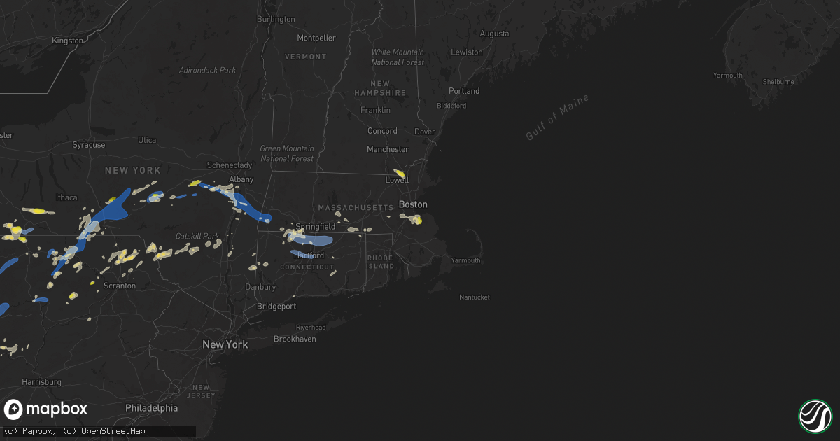
Hail Map on July 7, 2021
Get this storm
July 7 map
$229
one time, instant access
Download today. No call, no setup
Keep the $229
Bought the map and want the full workflow? Apply the entire $229 to a subscription within 7 days. None of it is wasted.
Every map, not just this one
This buys you this map. Subscription and you get every map we run, in the markets you choose from a few cities to whole states to nationwide. Plus real-time alerts the moment a storm fires.
Contact data
Name, contact info, occupancy, even credit band for addresses in the footprint. You go from where it hit to who to call.
Become the source they trust
Unlimited branding weather history reports on demand. You already have the documented answer ready for the property owner, and you are the one who showed up with it.
Property data and RoofTrace estimates
Pull up any address you have got, its value and the exact code rules for that jurisdiction, straight from One Click Code. Then RoofTrace estimates the squares, pitch, and roof value, priced the way you price.
States Impacted by Hail Map on July 7, 2021
Storm reports
New Hampshire
| Date | Description |
|---|---|
| 07/07/20213:45 PM CDT | Downed trees highway 38. |
| 07/07/20213:40 PM CDT | A local report indicates 1.00 inch wind near 2 E PELHAM |
| 07/07/20213:38 PM CDT | Shredded leaves and covered parts of lawns. |
| 07/06/202111:33 PM CDT | At 433 PM EDT, a severe thunderstorm was located over Boxford, or near North Andover, moving southeast at 20 mph. HAZARD...60 mph wind gusts and penny size hail. SOURCE...Radar indicated. IMPACT...Expect damage to trees and power lines. Locations impacted include... Lynn, Lawrence, Haverhill, Peabody, Methuen, Salem, Beverly, Andover, Dracut, Tewksbury, Gloucester, North Andover, Danvers, Wilmington, Marblehead, North Reading, Swampscott, Ipswich, Lynnfield and Middleton. |
Wyoming
| Date | Description |
|---|---|
| 07/07/20216:20 PM CDT | A local report indicates 58 MPH wind near 5 NNW DWTN GILLETTE |
| 07/07/20215:41 PM CDT | Delayed report. Time estimated from radar. |
| 07/07/20214:13 AM CDT | At 912 PM MDT, severe thunderstorms were located along a line extending from 14 miles west of Colstrip to 12 miles south of Lame Deer to 15 miles north of Sheridan, moving east at 30 mph. HAZARD...60 mph wind gusts. SOURCE...Radar indicated. IMPACT...Expect damage to roofs, siding, and trees. Locations impacted include... Lame Deer, Ashland, Birney, Tongue River Reservoir, Otter, Sonnette, Moorhead, Muddy Cluster, Birney Village and Northern Cheyenne Indian Reservation.This replaces the warning previously in effect for this area. |
| 07/07/20213:23 AM CDT | At 821 PM MDT, severe thunderstorms were located along a line extending from 12 miles east of Hardin to 8 miles southeast of Crow Agency to 16 miles southwest of Lodge Grass, moving southeast at 55 mph. HAZARD...60 mph wind gusts. SOURCE...Radar indicated. IMPACT...Expect damage to roofs, siding, and trees. Locations impacted include... Lodge Grass, Lame Deer, Busby, Crow Agency, Ashland, Birney, Wyola, Tongue River Reservoir, Birney Village, Brandenberg, Kirby, Muddy Cluster, Rosebud Battlefield Park, Northern Cheyenne Indian Reservation and Crow Indian Reservation.This replaces the warning previously in effect for this area. |
| 07/06/202111:43 PM CDT | At 441 PM MDT, severe thunderstorms were located along a line extending from 8 miles west of Clyde Park to 16 miles north of Crescent Lake, moving east at 45 mph. HAZARD...60 mph wind gusts and dime size hail. SOURCE...Radar indicated. IMPACT...Expect damage to roofs, siding, and trees. Locations impacted include... Livingston, Clyde Park, Sportsman Lake, Slide Lake, Rainbow Lake, Electric Peak, Gardiner, Crescent Lake, North Entrance, Chico Hot Springs, Springdale, Pine Creek, Chico, Corwin Springs, Wilsall, Emigrant and Jardine. |
| 07/06/20218:00 PM CDT | A local report indicates 60 MPH wind near 14 SW SUNDANCE |
Virginia
| Date | Description |
|---|---|
| 07/07/20216:10 PM CDT | A local report indicates 1.00 inch wind near 1 WNW RILEYVILLE |
| 07/07/20214:36 PM CDT | Tree down near the intersection of george wind road and briery branch road. |
| 07/07/20213:36 PM CDT | Downed wires resulting in a grass fire in the 200 block of middlebrook road. |
| 07/07/20213:31 PM CDT | Minor tree damage reported southwest of charlottesville |
| 07/07/20213:18 PM CDT | Several downed and uprooted trees. |
| 07/07/20213:13 PM CDT | Large tree down along east riverside drive. |
| 07/07/20213:13 PM CDT | Tree down in the 1200 block of shockeysville road. |
| 07/07/20213:13 PM CDT | Large tree down near rogers lane and lone pine road. |
| 07/07/20213:13 PM CDT | Large tree uprooted along 2nd avenue in timberville. |
| 07/07/20212:59 PM CDT | Two trees and large branch down in vicinity of wintergreen resort |
| 07/07/20212:03 AM CDT | At 703 PM EDT, a severe thunderstorm was located near Luray, or 9 miles southeast of Woodstock, moving northeast at 15 mph. HAZARD...60 mph wind gusts and quarter size hail. SOURCE...Radar indicated. IMPACT...Damaging winds will cause some trees and large branches to fall. This could injure those outdoors, as well as damage homes and vehicles. Roadways may become blocked by downed trees. Localized power outages are possible. Unsecured light objects may become projectiles. Locations impacted include... Saint Davids Church, Bentonville, Kings Crossing, Compton, Seven Fountains, Browntown and Rileyville. |
| 07/07/202112:34 AM CDT | At 533 PM EDT, a severe thunderstorm was located near Star Tannery, or near Strasburg, moving north at 30 mph. HAZARD...60 mph wind gusts and half dollar size hail. SOURCE...Radar indicated. IMPACT...Damaging winds will cause some trees and large branches to fall. This could injure those outdoors, as well as damage homes and vehicles. Roadways may become blocked by downed trees. Localized power outages are possible. Unsecured light objects may become projectiles. Locations impacted include... Strasburg, Star Tannery, Capon Bridge, Gravel Springs, Yellow Spring, High View, High View Manor, Wilde Acres, Rock Enon Springs, Fishers Hill, Gore, Capon Springs and Lehew. |
| 07/06/202111:40 PM CDT | At 439 PM EDT, a severe thunderstorm was located over Staunton, moving north at 15 mph. HAZARD...60 mph wind gusts and quarter size hail. SOURCE...Radar indicated. IMPACT...Damaging winds will cause some trees and large branches to fall. This could injure those outdoors, as well as damage homes and vehicles. Roadways may become blocked by downed trees. Localized power outages are possible. Unsecured light objects may become projectiles. Locations impacted include... Staunton, Verona, Mount Sidney, Churchville and Moscow. |
| 07/06/202110:45 PM CDT | At 345 PM EDT, a severe thunderstorm was located near Wintergreen, or 14 miles south of Waynesboro, and is nearly stationary. HAZARD...60 mph wind gusts and quarter size hail. SOURCE...Radar indicated. IMPACT...Damaging winds will cause some trees and large branches to fall. This could injure those outdoors, as well as damage homes and vehicles. Roadways may become blocked by downed trees. Localized power outages are possible. Unsecured light objects may become projectiles. Locations impacted include... Sherando, Wintergreen, Lyndhurst, Nellysford, Bryant and Tyro. |
Connecticut
| Date | Description |
|---|---|
| 07/07/20215:10 PM CDT | Multiple trees down on brickyard road |
| 07/07/20215:00 PM CDT | Multiple trees and wires down on rockridge road at rte 195 |
| 07/07/20214:57 PM CDT | Large tree limbs down on power lines. |
| 07/07/20214:55 PM CDT | Trees and wires down on old willimantic road |
| 07/07/20214:52 PM CDT | Trees and wires down on new city road |
| 07/07/20214:48 PM CDT | Wires were downed |
| 07/07/20214:35 PM CDT | Tree down on a house on pinnacle road |
| 07/07/20214:30 PM CDT | Tree and wires down on hall hill road |
| 07/07/20214:30 PM CDT | Large tree blocking rte 85 at riga lane |
| 07/07/20214:25 PM CDT | Tree down on interstate 291 at rte 384 blocking right hand lane |
| 07/07/20214:25 PM CDT | Large tree down on pleasant valley road |
| 07/07/20214:08 PM CDT | A local report indicates 61 MPH wind near BRADLEY AP |
| 07/07/20214:05 PM CDT | Power lines down on rte 75 |
| 07/07/20214:00 PM CDT | Tree down onto a house on cherry brook road |
| 07/07/20211:38 AM CDT | At 637 PM EDT, a severe thunderstorm was located over Manchester, moving east at 30 mph. HAZARD...60 mph wind gusts and penny size hail. SOURCE...Radar indicated. IMPACT...Expect damage to trees and power lines. Locations impacted include... Hartford, Manchester, East Hartford, Glastonbury, Vernon, Windsor, Wethersfield, Mansfield, South Windsor, Windham, Willimantic, Ellington, Tolland, Windsor Locks, Coventry, East Windsor, Hebron, Marlborough, Willington and Columbia. |
| 07/07/20211:17 AM CDT | At 616 PM EDT, severe thunderstorms were located along a line extending from Auburn to near Pomfret to Preston, moving east at 40 mph. HAZARD...60 mph wind gusts and penny size hail. SOURCE...Radar indicated. IMPACT...Expect damage to trees and power lines. Locations impacted include... Worcester, Providence, Newton, Warwick, Cranston, Pawtucket, Framingham, East Providence, Woonsocket, Shrewsbury, Coventry, Cumberland, Natick, North Providence, Franklin, West Warwick, Needham, Johnston, North Attleborough and Norwood. |
| 07/07/202112:43 AM CDT | At 543 PM EDT, severe thunderstorms were located along a line extending from near Wales to Hebron to near Glastonbury, moving southeast at 35 mph. HAZARD...60 mph wind gusts. SOURCE...Radar indicated. IMPACT...Expect damage to trees and power lines. Severe thunderstorms will be near... Colchester and East Hampton around 550 PM EDT. Lake Pocotopaug--East Hampton around 555 PM EDT. East Haddam and Bozrah around 600 PM EDT. Salem around 605 PM EDT. North Lyme around 615 PM EDT. East Lyme and Lyme around 620 PM EDT. Groton and Waterford around 625 PM EDT. New London and Mystic around 630 PM EDT. |
| 07/07/202112:30 AM CDT | At 529 PM EDT, severe thunderstorms were located along a line extending from near Monson to Ellington to Glastonbury, moving east at 30 mph. HAZARD...60 mph wind gusts and penny size hail. SOURCE...Radar indicated. IMPACT...Expect damage to trees and power lines. Locations impacted include... Manchester, East Hartford, Enfield, Glastonbury, Vernon, Wethersfield, Mansfield, South Windsor, Windham, Plainfield, Rocky Hill, Willimantic, Killingly, Webster, Southbridge, East Longmeadow, Ellington, Tolland, Wilbraham and Oxford. |
| 07/06/202111:00 PM CDT | At 400 PM EDT, a severe thunderstorm was located near Sandisfield, or near Great Barrington, moving east at 20 mph. HAZARD...60 mph wind gusts and penny size hail. SOURCE...Radar indicated. IMPACT...Expect damage to trees and power lines. Locations impacted include... Westfield, Holyoke, Suffield, Granby, Southwick, Southampton, East Granby, Huntington, Hartland, Russell, Granville, Blandford, Montgomery and Tolland. |
Indiana
| Date | Description |
|---|---|
| 07/07/20214:15 PM CDT | Tree limb down onto power line. |
| 07/07/20214:10 PM CDT | Tree uprooted and downed on a building at greencroft. Estimated wind gust to 40-45 mph... Only small branches down around town. No other report of damage. |
| 07/07/20213:44 PM CDT | Report of a tree downed on a power line along s 250 w. Size and health of the tree unknown. |
| 07/07/20212:26 AM CDT | At 725 PM EDT/625 PM CDT/, a severe thunderstorm was located near Culver, or 7 miles southeast of Knox, moving east at 40 mph. HAZARD...60 mph wind gusts and quarter size hail. SOURCE...Radar indicated. IMPACT...Hail damage to vehicles is expected. Expect wind damage to roofs, siding, and trees. Locations impacted include... Plymouth, Knox, Bourbon, Argos, Culver, Walnut, Tippecanoe, Oak Grove, Monterey, Leiters Ford, Beardstown, Ober, Hibbard, Winona, Delong, Old Tip Town, Donaldson, Tiosa, Talma and Twin Lakes. |
| 07/06/20219:31 PM CDT | At 230 PM EDT, a severe thunderstorm was located near Three Oaks, or 13 miles northeast of Trail Creek, moving northeast at 25 mph. HAZARD...60 mph wind gusts and penny size hail. SOURCE...Radar indicated. IMPACT...Expect damage to roofs, siding, and trees. Locations impacted include... Buchanan, Bridgman, New Buffalo, Three Oaks, Stevensville, Shorewood-Tower Hill, Shorewood-Tower Hills-Harbert, Baroda, Galien, Union Pier, Glendora, New Troy, Harbert, Sawyer, Turner Shores and Lakeside In Berrien County.This includes Interstate 94 in Michigan between mile markers 0 and25. |
| 07/06/20218:33 PM CDT | Sudden burst of winds estimated around 60 mph. |
Florida
| Date | Description |
|---|---|
| 07/07/20214:10 PM CDT | Trees down and debris on the road at university and i-95. Power is out parts of the area. Reported by media via twitter. |
| 07/07/20213:49 PM CDT | Doppler radar and public videos confirmed a tornado in jacksonville... Florida. There was private property damage near phillips highway and bowden road. There was also |
| 07/07/20213:49 PM CDT | Radar indicated a debris ball confirming a tornado in concert with verbal confirmation from emergency management for damage consistent of a tornado in the 5400 block of |
| 07/07/20213:48 PM CDT | Storm damage to private property in the area of phillips highway and bowden road possibly associated with a potential tornado in the outer bands of ts elsa. |
| 07/07/20212:30 PM CDT | *** 1 fatal *** in the ortega neighborhood in jacksonville... There was a confirmed fatality with a tree felling on two cars on roosevelt blvd. |
Louisiana
| Date | Description |
|---|---|
| 07/07/202112:19 AM CDT | At 519 PM CDT, a severe thunderstorm was located over Galliano, moving east at 15 mph. HAZARD...60 mph wind gusts. SOURCE...Radar indicated. IMPACT...Expect damage to roofs, siding, and trees. Locations impacted include... Galliano, Cut Off and Golden Meadow. |
New York
| Date | Description |
|---|---|
| 07/07/20216:20 PM CDT | Trees down on power lines along edith ave |
| 07/07/20216:13 PM CDT | Tree down on power lines |
| 07/07/20216:13 PM CDT | Tree down on power lines along county rd 38 |
| 07/07/20216:10 PM CDT | Tree down across road on cr16... No wires involved. |
| 07/07/20216:09 PM CDT | Trees down on power lines along north nesmith ave |
| 07/07/20216:09 PM CDT | Trees down on power lines along north nesmith ave. |
| 07/07/20216:03 PM CDT | Trees down on power lines. |
| 07/07/20216:03 PM CDT | Trees down on power lines near diffley rd |
| 07/07/20215:51 PM CDT | Several trees were downed blocking lawson lake road |
| 07/07/20215:17 PM CDT | Tree down on oregon road blocking 2/3rds of the roadway. Time estimated. |
| 07/07/20214:50 PM CDT | A local report indicates 1.00 inch wind near ONEONTA |
| 07/07/20214:45 PM CDT | Trees and utility lines down on north kortwright church road. |
| 07/07/20214:40 PM CDT | Tree down on power service on resident with smoke filling house. |
| 07/07/20214:38 PM CDT | Downed tree blocking county highway 3a. |
| 07/07/20214:35 PM CDT | Trees and utility lines down on buck road. |
| 07/07/20214:33 PM CDT | Tree leaning on wires and on fire on four corners road between jackson and elm |
| 07/07/20214:33 PM CDT | Tree and wires down on county route 7 between westfall road and tims road |
| 07/07/20214:30 PM CDT | Several trees down in town of davenport with one tree into a residence. |
| 07/07/20212:29 PM CDT | Trees down on wires and one tree down on an unoccupied car on south waldron lane |
| 07/07/20212:17 PM CDT | Route 9j closed between day road and route 26a near stockport due to downed trees |
| 07/07/20212:12 PM CDT | Trees down on wires at route 9j and county route 46 |
| 07/07/20212:11 PM CDT | Several reports of trees and wires down in the stuyvesant area |
| 07/07/20212:04 PM CDT | Several reports of trees down between new baltimore and coxsackie |
| 07/07/20211:50 PM CDT | Several trees were downed in coeymans hollow. Route 143 was closed between blodgett hill road and gedney hill road due to a downed tree and wires. |
| 07/07/20211:10 PM CDT | Live tree around 6 inches in diameter snapped. Also a few large 3-4 inch diameter branches downed in a yard. |
| 07/07/20211:04 PM CDT | Tree snapped and large branches down with siding damage near route 30 at carriage house lane and pleasant valley road |
| 07/07/20211:04 PM CDT | A few trees and several branches down of various sizes along hard scrabble road |
| 07/07/202112:45 PM CDT | Several reports of trees downed in richmondville |
| 07/07/20216:20 AM CDT | At 1119 PM EDT, severe thunderstorms were located along a line extending from near Exeter Center to Davenport to near Andes, moving northeast at 45 mph. HAZARD...60 mph wind gusts and penny size hail. SOURCE...Radar indicated. IMPACT...Expect damage to roofs, siding, and trees. Locations impacted include... Johnstown, Ilion, Herkimer, Little Falls, Cobleskill, Canajoharie, Fonda, Jefferson, Mohawk, Frankfort, Fort Plain, Dolgeville, St. Johnsville, Ephratah, Middleburgh, Gilboa, Summit, Schoharie, Richmondville and West Winfield. |
| 07/07/20216:02 AM CDT | At 1102 PM EDT, severe thunderstorms were located along a line extending from 8 miles southwest of Margaretville to Kerhonkson, moving northeast at 45 mph. HAZARD...60 mph wind gusts and penny size hail. SOURCE...Radar indicated. IMPACT...Expect damage to roofs, siding, and trees. Locations impacted include... Kingston, Ellenville, Saugerties, Hunter, Hurley, Woodstock, Clermont, Red Hook, Windham, Prattsville, Napanoch, Woodland Valley Campground, Phoenicia, Mount Tremper, Olivebridge, Kerhonkson, West Hurley, Saugerties South, North-South Lake Campground and West Shokan. |
| 07/07/20215:41 AM CDT | At 1041 PM EDT, severe thunderstorms were located along a line extending from near Plymouth to near Harvard, moving east at 45 mph. HAZARD...60 mph wind gusts and quarter size hail. SOURCE... These storms have produced widespread downed trees and wires with widespread power outages. IMPACT...Hail damage to vehicles is expected. Expect wind damage to roofs, siding, and trees. Locations impacted include... Oneonta, Norwich, Sidney, Walton, Delhi, Davenport, Guilford, Roxbury, Worcester and Middlefield. |
| 07/07/20215:06 AM CDT | At 1004 PM EDT, severe thunderstorms were located along a line extending from near Berkshire to near Royal, moving northeast at 45 mph. HAZARD...70 mph wind gusts and quarter size hail. SOURCE...Radar indicated. IMPACT...70 mph gusts with a danergrous microburst near Binghamton airport moving northeast toward Chenango Forks and Whitney Point. Elsewhere with 60 mph gusts, Hail damage to vehicles is expected. Expect considerable tree damage. Wind damage is also likely to mobile homes,roofs, and outbuildings. Locations impacted include... Binghamton, Vestal, Johnson City, Endicott, Norwich, Kirkwood, Conklin, Maine, Sidney and Jackson. |
| 07/07/20214:24 AM CDT | At 923 PM EDT, severe thunderstorms were located along a line extending from Van Etten to Sweet Valley, moving northeast at 35 mph. HAZARD...60 mph wind gusts and quarter size hail. SOURCE... Several reports of downed trees and wires. IMPACT...Hail damage to vehicles is expected. Expect wind damage to roofs, siding, and trees. Locations impacted include... Binghamton, Falls, Vestal, Muhlenberg, Johnson City, Endicott, Barton, Vernon, Maine and Rush. |
| 07/07/20213:38 AM CDT | At 838 PM EDT, severe thunderstorms were located along a line extending from Meads Creek to 7 miles northwest of Mansfield, moving east at 40 mph. HAZARD...70 mph wind gusts and quarter size hail. SOURCE... Trees and Wires have been downed due to winds. IMPACT...Hail damage to vehicles is expected. Expect considerable tree damage. Wind damage is also likely to mobile homes, roofs, and outbuildings. Locations impacted include... Chemung, Elmira, Corning, Southport, Barton, Big Flats, Horseheads, Sayre, Waverly and Elmira Heights. |
| 07/07/20213:25 AM CDT | At 825 PM EDT, a severe thunderstorm was located over Sherman, moving east at 20 mph. HAZARD...60 mph wind gusts and quarter size hail. SOURCE...Radar indicated. IMPACT...Minor hail damage to vehicles is possible. Expect wind damage to trees and power lines. This severe thunderstorm will be near... Sherman around 830 PM EDT. |
| 07/07/20213:23 AM CDT | At 823 PM EDT, a severe thunderstorm was located over Gaylordsville, or near Sherman, moving east at 25 mph. HAZARD...60 mph wind gusts and quarter size hail. SOURCE...Radar indicated. IMPACT...Hail damage to vehicles is expected. Expect wind damage to roofs, siding, and trees. Locations impacted include... New Milford, Thomaston, Oakville, New Preston, Terryville, Woodbury Center, Wingdale, Gaylordsville, Watertown, Plymouth, Woodbury, Bethlehem, Washington, Morris, Roxbury, Bridgewater, Bantam, Hotchkissville, Pequabuck and Baker Corner. |
| 07/07/20213:04 AM CDT | At 804 PM EDT, a severe thunderstorm was located near Elkland, moving east at 20 mph. HAZARD...60 mph wind gusts and quarter size hail. SOURCE...Radar indicated. IMPACT...Hail damage to vehicles is expected. Expect wind damage to roofs, siding, and trees. Locations impacted include... Elkland, Millerton, Tioga, Knoxville, Osceola and Tioga Junction. |
| 07/07/20212:55 AM CDT | At 755 AM EDT, a severe thunderstorm was located over Scipio Center, or 11 miles south of Auburn, moving east at 35 mph. HAZARD...60 mph wind gusts and penny size hail. SOURCE...Radar indicated. IMPACT...Expect damage to roofs, siding, and trees. Locations impacted include... Owasco, Fleming, Locke, Genoa, Ledyard, Moravia, Union Springs, Niles, Scott and Sempronius. |
| 07/07/20212:12 AM CDT | At 711 PM EDT, a severe thunderstorm was located near Genesee, moving east at 20 mph. HAZARD...60 mph wind gusts and penny size hail. SOURCE...Radar indicated. IMPACT...Expect damage to roofs, siding, and trees. Locations impacted include... Whitesville, Andover, Stannards and Paynesville. |
| 07/07/20212:08 AM CDT | At 708 PM EDT, a severe thunderstorm was located near Hartwick, or 10 miles north of Oneonta, moving northeast at 20 mph. HAZARD...60 mph wind gusts and quarter size hail. SOURCE...Radar indicated. IMPACT...Hail damage to vehicles is expected. Expect wind damage to roofs, siding, and trees. Locations impacted include... Worcester, Middlefield, Hartwick, Cooperstown, Westville, New Lisbon, Westford, Cherry Valley, Milford and Bowerstown. |
| 07/07/20212:03 AM CDT | At 703 PM EDT, a severe thunderstorm was located 7 miles east of Belfast, or 12 miles north of Wellsville, moving east at 25 mph. HAZARD...60 mph wind gusts and quarter size hail. SOURCE...Radar indicated. IMPACT...Minor damage to vehicles is possible. Expect wind damage to roofs, siding, and trees. Locations impacted include... Alfred, Belfast, Friendship, Belmont, Angelica, Canaseraga, Almond, West Almond and Birdsall. This includes Interstate 86 between exits 29 and 33. |
| 07/07/20211:47 AM CDT | At 646 PM EDT, severe thunderstorms were located along a line extending from Wattsburg to near Sheffield, moving northeast at 45 mph. HAZARD...60 mph wind gusts and penny size hail. SOURCE...Radar indicated. IMPACT...Expect damage to roofs, siding, and trees. Locations impacted include... Jamestown, Olean, Fredonia, Salamanca, Allegany State Park, Westfield, Lakewood, Falconer, Allegany, Panama, Busti, and Mayville. This includes the following highways... Interstate 90 between exits 61 and 60. Interstate 86 between exits 4 and 26. |
| 07/07/20211:43 AM CDT | At 641 PM EDT, a severe thunderstorm was located near Port Allegany, moving east at 30 mph. HAZARD...70 mph wind gusts and quarter size hail. SOURCE...Law enforcement reported hail and numerous downed trees in the path of this storm. IMPACT...Hail damage to vehicles is expected. Expect considerable tree damage. Wind damage is also likely to mobile homes, roofs, and outbuildings. Locations impacted include... Coudersport, Port Allegany, Roulette, Shinglehouse, Genesee, Denton Hill State Park, Harrison Valley, Ulysses, Sweden Valley, Oswayo and Ski Denton Ski Area. |
| 07/07/20211:35 AM CDT | At 635 PM EDT, a severe thunderstorm was located over Summit, or 11 miles southwest of Cobleskill, moving east at 25 mph. HAZARD...60 mph wind gusts and nickel size hail. SOURCE...Radar indicated. IMPACT...Expect damage to roofs, siding, and trees. Locations impacted include... Berne, Middleburgh, Summit, Schoharie, Breakabeen, Knox, Baird Corners, West Berne, Huntersland, Old Stone Fort, Lutheranville, West Fulton, Vintonton, Arabia, Eminence, Housons Corners, Beards Hollow, Zucks Corners, Watsonville and West Township. |
| 07/07/20211:31 AM CDT | At 631 PM EDT, a severe thunderstorm was located over Monterey, or 10 miles north of Corning, moving east at 25 mph. HAZARD...60 mph wind gusts and quarter size hail. SOURCE...Radar indicated. IMPACT...Hail damage to vehicles is expected. Expect wind damage to roofs, siding, and trees. Locations impacted include... Horseheads, Catharine, Hornby, Millport, Meads Creek, Horseheads North, Monterey, Fisherville, Mark Twain State Park and Beaver Dams. |
| 07/07/20211:29 AM CDT | At 629 PM EDT, severe thunderstorms were located along a line extending from Grand Valley to 10 miles southwest of Sheffield, moving northeast at 35 mph. HAZARD...60 mph wind gusts and quarter size hail. SOURCE...Radar indicated. IMPACT...Hail damage to vehicles is expected. Expect wind damage to roofs, siding, and trees. Locations impacted include... Warren, Sheffield, Youngsville, Russell, Spring Creek, Scandia, Lottsville, Grand Valley, Warren South, Garland, Kinzua Dam, Chapman State Park, Ludlow, Tidioute, Sugar Grove, Starbrick and Clarendon. |
| 07/07/20211:25 AM CDT | At 625 PM EDT, a severe thunderstorm was located near Middleburgh, or 12 miles southeast of Cobleskill, moving east at 25 mph. HAZARD...60 mph wind gusts and nickel size hail. SOURCE...Radar indicated. IMPACT...Expect damage to roofs, siding, and trees. Locations impacted include... Westerlo, Berne, Voorheesville, Altamont, Middleburgh, Livingstonville, Feura Bush, Breakabeen, New Scotland, Knox, Rensselaerville, Clarksville, East Berne, Meadowdale, Shoefelt Corners, South Albany, West Berne, Huntersland, Selkirk Yards and Spawn Hollow. |
| 07/07/20211:10 AM CDT | At 610 PM EDT, a severe thunderstorm was located near Gilbertsville, or near Norwich, moving northeast at 20 mph. HAZARD...60 mph wind gusts and quarter size hail. SOURCE...Radar indicated. IMPACT...Hail damage to vehicles is expected. Expect wind damage to roofs, siding, and trees. Locations impacted include... Oneonta, New Lisbon, Morris, Gilbertsville, Laurens, West End, Emmons, Mt Vision, Gilbert Lake State Park and Lathams Corners. |
| 07/07/20211:06 AM CDT | At 606 PM EDT, a severe thunderstorm was located over Feura Bush, or near Delmar, moving east at 30 mph. HAZARD...60 mph wind gusts and penny size hail. SOURCE...Radar indicated. IMPACT...Expect damage to roofs, siding, and trees. Locations impacted include... Albany, East Greenbush, Rensselaer, Nassau, Delmar, Ravena, Stephentown, Berlin, Castleton-On-Hudson, West Sand Lake, Averill Park, Feura Bush, Selkirk, Sand Lake, Coeymans, Poestenkill, Clarksville, East Nassau, Coeymans Hollow and Brookview. |
| 07/07/20211:00 AM CDT | At 600 PM EDT, a severe thunderstorm was located over Cayuta, or near Odessa, moving east at 20 mph. HAZARD...60 mph wind gusts and quarter size hail. SOURCE...Radar indicated. IMPACT...Hail damage to vehicles is expected. Expect wind damage to roofs, siding, and trees. Locations impacted include... Spencer, Cayuta, Van Etten, Willseyville, South Danby, West Danby, North Spencer, West Candor, Swartwood and Alpine. |
| 07/07/202112:55 AM CDT | At 554 PM EDT, a severe thunderstorm was located near Cyclone, moving east at 20 mph. HAZARD...60 mph wind gusts and quarter size hail. SOURCE...Radar indicated. IMPACT...Hail damage to vehicles is expected. Expect wind damage to roofs, siding, and trees. Locations impacted include... Bradford, Port Allegany, Smethport, Rew, Coryville, Cyclone, Eldred, Lewis Run, University Of Pittsburgh - Bradford and Bradford Airport. |
| 07/07/202112:47 AM CDT | At 546 PM EDT, a severe thunderstorm was located over Smithville Flats, or 12 miles east of Marathon, moving east at 15 mph. HAZARD...60 mph wind gusts and nickel size hail. SOURCE...Radar indicated. IMPACT...Expect damage to roofs, siding, and trees. Locations impacted include... Guilford, Oxford, Brisben, Smithville Flats, South Oxford, Smithville Center and Tyner. |
| 07/07/202112:42 AM CDT | At 541 PM EDT, a severe thunderstorm was located near Davenport, or 14 miles northeast of Delhi, moving east at 30 mph. HAZARD...60 mph wind gusts and quarter size hail. SOURCE...Radar indicated. IMPACT...Hail damage to vehicles is expected. Expect wind damage to roofs, siding, and trees. Locations impacted include... Jefferson, Gilboa, North Blenheim, Breakabeen, Conesville, Baird Corners, Manorkill, Broome Center, West Fulton, Five Corners, Arabia, West Conesville, Eminence, Housons Corners, West Jefferson, South Gilboa, South Jefferson, Watsonville, Vorman Corners and Ruth. |
| 07/07/202112:40 AM CDT | At 540 PM EDT, a severe thunderstorm was located near Davenport, or 14 miles northeast of Delhi, moving east at 25 mph. HAZARD...60 mph wind gusts and nickel size hail. SOURCE...Radar indicated. IMPACT...Expect damage to roofs, siding, and trees. Locations impacted include... Kortright, Stamford and Butts Corner. |
| 07/07/202112:13 AM CDT | At 513 PM EDT, a severe thunderstorm was located near Otego, or 9 miles southwest of Oneonta, moving east at 25 mph. HAZARD...60 mph wind gusts and quarter size hail. SOURCE...Radar indicated. IMPACT...Hail damage to vehicles is expected. Expect wind damage to roofs, siding, and trees. Locations impacted include... Oneonta, Delhi, Davenport, Maryland, Kortright, Meredith, Unadilla, Otego, Franklin and West End. |
| 07/07/202112:07 AM CDT | At 506 PM EDT, a severe thunderstorm was located over Scandia, moving east at 15 mph. HAZARD...60 mph wind gusts and quarter size hail. SOURCE...Radar indicated. IMPACT...Hail damage to vehicles is expected. Expect wind damage to roofs, siding, and trees. Locations impacted include... Bradford, Scandia, Marshburg, Kinzua Dam, Lewis Run, University Of Pittsburgh - Bradford and Bradford Airport. |
| 07/06/202111:20 PM CDT | A tree was downed on route 9g between hyde park and rhinebeck |
| 07/06/202111:12 PM CDT | A tree was downed onto a house on creek locks road |
| 07/06/202111:02 PM CDT | Tree down on wires on pine bush road near stilba lane |
| 07/06/202111:02 PM CDT | Tree down on wires on atwood road near vly atwood road |
| 07/06/202111:00 PM CDT | Trees down on grovers corners road in the town of carlisle. |
| 07/06/202110:58 PM CDT | Tree down on wires on route 209 |
| 07/06/202110:54 PM CDT | A tree was downed in the roadway on foordmoore road near routes 44 and 55 |
| 07/06/202110:40 PM CDT | Tree down on wires. |
| 07/06/202110:29 PM CDT | At 328 PM EDT, a severe thunderstorm was located near Lorenz Park, or near Hudson, moving southeast at 25 mph. HAZARD...60 mph wind gusts and penny size hail. SOURCE...Radar indicated. IMPACT...Expect damage to roofs, siding, and trees. Locations impacted include... Hudson, Chatham, Claverack, Copake, New Baltimore, Coxsackie, Valatie, Athens, Austerlitz, Philmont, Kinderhook, Lorenz Park, Claverack-Red Mills, Ghent, Stockport, Stuyvesant, Hillsdale, Taghkanic, Churchtown and Rossman. |
| 07/06/202110:25 PM CDT | Trees and wires down on airport road. Via scanner. |
| 07/06/202110:15 PM CDT | Tree down on stanton corners road. Via dispatch scanner. Radar estimated time. |
| 07/06/202110:10 PM CDT | Tree down across stanton corners road... Via scanner. Other trees down in area. Radar estimated time. |
| 07/06/202110:05 PM CDT | Tree down on wires. |
| 07/06/202110:00 PM CDT | Trees down. Also... Water and rocks over fuller hill road. Via dispatch scanner. Radar estimated time. |
| 07/06/20219:58 PM CDT | At 257 PM EDT, a severe thunderstorm was located over New Baltimore, or 9 miles west of Nassau, moving east at 40 mph. HAZARD...70 mph wind gusts and penny size hail. SOURCE...Radar indicated. IMPACT...Expect considerable tree damage. Damage is likely to mobile homes, roofs, and outbuildings. Locations impacted include... Chatham, Nassau, New Baltimore, Ravena, Coxsackie, New Lebanon, Valatie, Austerlitz, Castleton-On-Hudson, Kinderhook, Selkirk, Coeymans, Ghent, Stuyvesant, Canaan, East Nassau, Brookview, Van Hoesen Station, Jacks Corners and Beckers Corners. |
| 07/06/20219:40 PM CDT | Trees and wires down blocking road. |
| 07/06/20219:36 PM CDT | Report from mping: 1-inch tree limbs broken; shingles blown off. |
| 07/06/20219:25 PM CDT | At 225 PM EDT, a severe thunderstorm was located near Berne, or 17 miles west of Delmar, moving east at 35 mph. HAZARD...60 mph wind gusts and penny size hail. SOURCE...Radar indicated. IMPACT...Expect damage to roofs, siding, and trees. Locations impacted include... Delmar, New Baltimore, Westerlo, Ravena, Coxsackie, Berne, Feura Bush, Preston Hollow, Selkirk, Preston-Potter Hollow, Coeymans, Rensselaerville, Clarksville, Coeymans Hollow, East Berne, Shoefelt Corners, West Berne, Spawn Hollow, Dormansville and Beckers Corners. |
| 07/06/20219:25 PM CDT | Upper lisle route 26 - trees blocking half of road in 2 spots... Another completely blocking merrill creek road. |
| 07/06/20219:15 PM CDT | Tree down all the way across patch road near high school. Reported to nws via social media. Radar estimated time. |
| 07/06/20219:11 PM CDT | Report from mping: quarter |
| 07/06/20219:10 PM CDT | 2 greenhouses blown over. Report to nws via social media. Radar estimated time. |
| 07/06/20219:00 PM CDT | Tree down on carl road. |
| 07/06/20218:55 PM CDT | Large tree down in backyard. Reported to nws by homeowner. Radar estimated time. |
| 07/06/20218:55 PM CDT | Tree down on vehicle. Other trees and wires down. |
| 07/06/20218:55 PM CDT | Tree down on car south of vestal center near state border. Pic sent to nws on social media. Radar estimated time. |
| 07/06/20218:55 PM CDT | Roof partially peeled off and awning damage at the 100 block of odell ave in the little italy section of endicott. Time estimated by radar. |
| 07/06/20218:53 PM CDT | Tree down blocking echo road. |
| 07/06/20218:50 PM CDT | Garage heavily damaged. Vehicle crushed. Pic reported to broadcast media... Sent to nws. Radar estimated time. |
| 07/06/20218:50 PM CDT | Tree down on vehicle with vehicle on fire. Trees and lines down. Report via social media. Radar estimated time. |
| 07/06/20218:48 PM CDT | Multiple trees and wires down... Blocking roads on south side of apalachin. Reported to nws via social media. Radar estimated time. |
| 07/06/20218:48 PM CDT | Commercial lighted sign knocked down/destroyed at visions credit union on ny-434. |
| 07/06/20218:48 PM CDT | Update to previous tstm wnd gst report from 1 ssw tioga terrace. Measured with kestrel anemometer. 1393 feet elevation on lillie hill road. Trunk snaps halfway up trees |
| 07/06/20217:58 PM CDT | Trees on route 20. |
| 07/06/20217:50 PM CDT | Multiple trees and wires down. Reported to nws via social media. Radar estimated time. |
| 07/06/20217:45 PM CDT | Wires down on trees. |
| 07/06/20217:35 PM CDT | Multiple trees down county route 5. |
| 07/06/20217:09 PM CDT | Tree down across martins corners rd |
Michigan
| Date | Description |
|---|---|
| 07/07/20214:33 PM CDT | Multiple reports of large trees and limbs down. |
| 07/07/20214:13 PM CDT | Battle creek executive airport. |
| 07/07/20214:12 PM CDT | Trees down. Table umbrella also broke. |
| 07/07/20213:58 PM CDT | Social media pictures of multiple approx 5 inch diameter tree limbs down. |
| 07/07/20213:49 PM CDT | Multiple large trees uprooted. |
| 07/07/20213:49 PM CDT | Social media pictures of multiple large tree limbs down in downtown farmington. |
| 07/07/20213:49 PM CDT | Spotter reports multiple trees down blocking roadways across the area. Some roads were impassible. |
| 07/07/20213:47 PM CDT | Multiple tree limbs downed near novi and 12 mile roads. |
| 07/07/20213:45 PM CDT | State police reporting wires down across both directions of i-275 near grand river. Some wires down on cars. |
| 07/07/20213:43 PM CDT | Reports of wires down. |
| 07/07/20213:30 PM CDT | Reports of wires down. |
| 07/07/20212:55 PM CDT | A large tree was blown down onto a house. |
| 07/07/20212:54 PM CDT | Spotter reports 8 inch diameter healthy tree limb down in middle of rock street. |
| 07/07/20212:54 PM CDT | Social media pictures of a large tree uprooted that landed on a house near masonic and harper. |
| 07/07/20212:51 PM CDT | Social media video of large tree limbs down at intersection of kelly and masonic blocking part of the road. |
| 07/07/20212:51 PM CDT | Spotter reports a few 5-6 inch diameter tree limbs down at melvin and ginley. |
| 07/07/20212:43 PM CDT | Central dispatch has recieved numerous reports of trees and wires down across southwestern livingston county. |
| 07/07/20212:18 PM CDT | Large tree limb downed near chestnut and elm streets in birmingham. |
| 07/07/20212:16 PM CDT | Numerous large tree limbs down around maple and cranbrook. |
| 07/07/20211:59 PM CDT | Social media pictures of numerous large tree limbs down in the detroit beach neighborhood. |
| 07/07/20211:49 PM CDT | State police reports multiple trees and power lines down in the groveland township area. |
| 07/07/20217:54 AM CDT | At 1254 PM EDT, a severe thunderstorm was located 8 miles east of Carson City, or 10 miles southwest of Ithaca, moving east at 25 mph. HAZARD...60 mph wind gusts and quarter size hail. SOURCE...Radar indicated. IMPACT...Hail damage to vehicles is expected. Expect wind damage to roofs, siding, and trees. Locations impacted include... Ithaca... Elsie... Eureka... North Star... Maple Rapids... Ashley... Perrinton... Pompeii... Middleton... Bannister... |
| 07/07/202112:18 AM CDT | At 518 PM EDT, a severe thunderstorm was located over Lansing, moving northeast at 20 mph. HAZARD...60 mph wind gusts and quarter size hail. SOURCE...Radar indicated. IMPACT...Hail damage to vehicles is expected. Expect wind damage to roofs, siding, and trees. Locations impacted include... Lansing... East Lansing... Edgemont Park... Waverly... Okemos... Holt... Haslett... |
| 07/07/202112:09 AM CDT | At 508 PM EDT, a severe thunderstorm was located over Detroit Zoo, or near Warren, moving east at 45 mph. HAZARD...60 mph wind gusts and penny size hail. SOURCE...Radar indicated. IMPACT...Expect damage to roofs, siding, and trees. This severe thunderstorm will be near... Warren around 515 PM EDT. St. Clair Shores around 525 PM EDT.Other locations impacted by this severe thunderstorm include CenterLine, Roseville, Clinton Township, Fraser, Utica, Eastpointe, GrossePointe Shores, Harper Woods and Grosse Pointe Woods. |
| 07/07/202112:06 AM CDT | At 506 PM EDT, a severe thunderstorm was located over Battle Creek, moving northeast at 30 mph. HAZARD...60 mph wind gusts. SOURCE...Radar indicated. IMPACT...Expect damage to roofs, siding, and trees. Locations impacted include... Battle Creek... Level Park-Oak Park... Brownlee Park... Bedford... Ceresco... |
| 07/06/202111:18 PM CDT | At 417 PM EDT, a severe thunderstorm was located near Brighton, moving east at 35 mph. HAZARD...60 mph wind gusts and quarter size hail. SOURCE...Radar indicated. IMPACT...Hail damage to vehicles is expected. Expect wind damage to roofs, siding, and trees. This severe thunderstorm will be near... South Lyon around 425 PM EDT. Milford around 430 PM EDT. Northville around 440 PM EDT. Novi around 445 PM EDT. West Bloomfield around 450 PM EDT. Southfield and Birmingham around 505 PM EDT. Troy, Royal Oak and Detroit Zoo around 510 PM EDT. Warren around 515 PM EDT.Other locations impacted by this severe thunderstorm includeFranklin, Keego Harbor, Waterford, Orchard Lake, Commerce, LathrupVillage, Auburn Hills, Bingham Farms, Lake Angelus and FarmingtonHills. |
| 07/06/202111:15 PM CDT | At 413 PM EDT, a severe thunderstorm was located near Harsens Island, or 7 miles southwest of Algonac, moving east at 40 mph. HAZARD...60 mph wind gusts and quarter size hail. SOURCE...Radar indicated. IMPACT...Hail damage to vehicles is expected. Expect wind damage to roofs, siding, and trees. This severe thunderstorm will be near... Algonac around 425 PM EDT.Other locations impacted by this severe thunderstorm includeAnchorville, Pearl Beach, Adair and Fair Haven.Additional thunderstorms may also strengthen and impact areas from Fair Haven to Marine City. |
| 07/06/202110:38 PM CDT | At 337 PM EDT, severe thunderstorms were located along a line extending from 8 miles southwest of Fowlerville to near Stockbridge to near Jackson, moving east at 35 mph. HAZARD...60 mph wind gusts and penny size hail. SOURCE...Radar indicated. IMPACT...Expect damage to roofs, siding, and trees. Severe thunderstorms will be near... Gregory around 350 PM EDT. Howell and Pinckney around 400 PM EDT. Chelsea around 405 PM EDT. Brighton, Dexter and Hamburg around 415 PM EDT. Whitmore Lake around 420 PM EDT. Ann Arbor around 425 PM EDT. South Lyon around 430 PM EDT. Salem around 435 PM EDT.Other locations impacted by these severe thunderstorms includePlainfield, Hudson Mills Metropark, Island Lake State RecreationArea, Delhi Mills, Barton Hills, Pinckney State Recreation Area,Hudson Mills, Parkers Corners, Lakeland and Lyndon Township. |
| 07/06/202110:26 PM CDT | At 322 PM EDT, a severe thunderstorm was located over Troy, moving east at 35 mph. HAZARD...60 mph wind gusts and quarter size hail. SOURCE...Radar indicated. IMPACT...Hail damage to vehicles is expected. Expect wind damage to roofs, siding, and trees. This severe thunderstorm will be near... Warren around 330 PM EDT. Sterling Heights around 335 PM EDT. Macomb Township around 340 PM EDT. St. Clair Shores and Mount Clemens around 345 PM EDT. New Baltimore around 400 PM EDT.Other locations impacted by this severe thunderstorm includeRoseville, Shelby Township, Ray Center, Fraser, Utica, Eastpointe,Washington, New Haven, Stoney Creek Metro Park and Center Line.Another severe thunderstorm will also track into the Romeo, Armada and Richmond areas over the next half hour or so. |
| 07/06/202110:10 PM CDT | At 309 PM EDT, a severe thunderstorm was located near New Baltimore, moving east at 25 mph. HAZARD...60 mph wind gusts and penny size hail. SOURCE...Radar indicated. IMPACT...Expect damage to roofs, siding, and trees. This severe thunderstorm will be near... Algonac around 320 PM EDT. St. Clair and Marine City around 325 PM EDT.Other locations impacted by this severe thunderstorm includeAnchorville, Adair, Columbus, Rattle Run, Pearl Beach, Smiths Creekand Fair Haven. |
| 07/06/20219:59 PM CDT | At 259 PM EDT, severe thunderstorms were located along a line extending from near Mason to 10 miles south of Eaton Rapids to near Burlington, moving east at 30 mph. HAZARD...60 mph wind gusts and quarter size hail. SOURCE...Radar indicated. IMPACT...Hail damage to vehicles is expected. Expect wind damage to roofs, siding, and trees. Locations impacted include... Lansing... Jackson... Albion... Mason... Eaton Rapids... East Lansing... Williamston... Leslie... Homer... Stockbridge... Brooklyn... Grass Lake... Burlington... Vandercook Lake... Leoni... Spring Arbor... Napoleon... Sandstone... Aurelius... Onondaga... |
| 07/06/20219:54 PM CDT | At 254 PM EDT, a severe thunderstorm was located over West Bloomfield, or near Novi, moving east at 25 mph. HAZARD...60 mph wind gusts and quarter size hail. SOURCE...Radar indicated. IMPACT...Hail damage to vehicles is expected. Expect wind damage to roofs, siding, and trees. This severe thunderstorm will be near... West Bloomfield around 300 PM EDT. Southfield and Birmingham around 320 PM EDT. Royal Oak and Detroit Zoo around 325 PM EDT. Troy around 330 PM EDT. Warren around 335 PM EDT. Sterling Heights around 345 PM EDT.Other locations impacted by this severe thunderstorm includeFranklin, Keego Harbor, Orchard Lake, Commerce, Lathrup Village,Bingham Farms, Farmington Hills, Pleasant Ridge, Huntington Woods andWolverine Lake. |
| 07/06/20219:47 PM CDT | At 247 PM EDT, a severe thunderstorm was located over Holly, moving east at 25 mph. HAZARD...60 mph wind gusts and quarter size hail. SOURCE...Radar indicated. IMPACT...Hail damage to vehicles is expected. Expect wind damage to roofs, siding, and trees. This severe thunderstorm will be near... Ortonville and Clarkston around 305 PM EDT. Oxford around 325 PM EDT. Almont around 345 PM EDT.Other locations impacted by this severe thunderstorm includeLakeville, Davisburg, Holly State Recreation Area, Leonard, RoseCenter, Lake Orion, Thornville, Lake Angelus, Auburn Hills andRochester Hills. |
| 07/06/20219:37 PM CDT | At 237 PM EDT, a severe thunderstorm was located 6 miles northwest of Albion, moving east at 25 mph. HAZARD...60 mph wind gusts and penny size hail. SOURCE...Radar indicated. IMPACT...Expect damage to roofs, siding, and trees. Locations impacted include... Albion... Marengo... Springport... Parma... Tompkins... |
| 07/06/20218:49 PM CDT | At 148 PM EDT, a severe thunderstorm was located over Henderson, or near Owosso, moving southeast at 25 mph. HAZARD...60 mph wind gusts and penny size hail. SOURCE...Radar indicated. IMPACT...Expect damage to roofs, siding, and trees. This severe thunderstorm will be near... Owosso around 200 PM EDT. Corunna around 210 PM EDT. Durand and Lennon around 230 PM EDT.Other locations impacted by this severe thunderstorm includeJuddville, Bennington, Carland and Vernon. |
| 07/06/20218:45 PM CDT | At 144 PM EDT, a severe thunderstorm was located near St. Johns, moving east at 20 mph. HAZARD...60 mph wind gusts and quarter size hail. SOURCE...Radar indicated. IMPACT...Hail damage to vehicles is expected. Expect wind damage to roofs, siding, and trees. Locations impacted include... St. Johns... Elsie... Ovid... |
New Mexico
| Date | Description |
|---|---|
| 07/07/20219:00 AM CDT | A local report indicates 1.00 inch wind near 3 NE TUCUMCARI |
Montana
| Date | Description |
|---|---|
| 07/07/20216:35 PM CDT | A local report indicates 60 MPH wind near 2 SSW BIG TIMBER |
| 07/07/20215:35 PM CDT | A local report indicates 58 MPH wind near 6 ENE BOZEMAN |
| 07/07/20215:34 PM CDT | Also reported pea size hail. |
| 07/07/20215:30 PM CDT | Report via spotter network. |
| 07/07/20215:25 PM CDT | Measured at kbzn. |
| 07/07/20214:55 PM CDT | Measured at keks. |
| 07/07/20214:08 PM CDT | Spotter reports winds snapping off large tree branches... As well as pea-size hail. |
| 07/07/20213:59 PM CDT | Second severe wind gust measured at klwt asos. |
| 07/07/20213:58 PM CDT | Power pole down on truck bypass |
| 07/07/20213:58 PM CDT | Updated. Nws estimates straight line winds of 75 to 85 mph throughout lewistown and nearby surrounding area. Previous report: power pole down on truck bypass |
| 07/07/20213:55 PM CDT | Measured at klwt. |
| 07/07/20213:55 PM CDT | Initial hailstones up to quarter size... Tapering to pea size on back edge of storm. Measured 0.27in of rain in only 7 minutes. |
| 07/07/20214:19 AM CDT | At 918 PM MDT, a severe thunderstorm was located 16 miles southwest of Ekalaka, moving east at 30 mph. HAZARD...70 mph wind gusts and quarter size hail. SOURCE...Radar indicated. IMPACT...Expect considerable tree damage. Wind damage is also likely to mobile homes, roofs, and outbuildings. Locations impacted include... Ekalaka, Belltower and Medicine Rocks State Park. |
| 07/07/20213:59 AM CDT | At 858 PM MDT, a severe thunderstorm was located 26 miles east of Volborg, or 27 miles west of Ekalaka, moving east at 30 mph. HAZARD...70 mph wind gusts and quarter size hail. SOURCE...Radar indicated. IMPACT...Expect considerable tree damage. Wind damage is also likely to mobile homes, roofs, and outbuildings. This severe thunderstorm will remain over mainly rural areas of southeastern Custer County.This replaces the warning previously in effect for this area. |
| 07/07/20213:14 AM CDT | At 813 PM MDT, a severe thunderstorm was located 12 miles north of Volborg, or 29 miles southeast of Miles City, moving east at 30 mph. HAZARD...60 mph wind gusts and quarter size hail. SOURCE...Radar indicated. IMPACT...Expect wind damage to roofs, siding, and trees. Locations impacted include... Volborg. |
| 07/07/20212:53 AM CDT | At 751 PM MDT, a severe thunderstorm was located near Miles City, moving east at 25 mph. HAZARD...60 mph wind gusts and nickel size hail. SOURCE...Radar indicated. IMPACT...Expect damage to roofs, siding, and trees. Locations impacted include... Miles City, Locate, Twelve Mile Dam, Strawberry Hill Recreation Area, Matthews Recreation Area and Mizpah. |
| 07/07/20212:48 AM CDT | At 748 PM MDT, a severe thunderstorm was located 21 miles northwest of West Glacier, or 38 miles north of Evergreen, moving northeast at 35 mph. HAZARD...60 mph wind gusts and quarter size hail. SOURCE...Radar indicated. IMPACT...Hail damage to vehicles is expected. Expect wind damage to roofs, siding, and trees. This severe thunderstorm will remain over mainly rural areas of north central Flathead County. |
| 07/07/20212:31 AM CDT | At 730 PM MDT, a severe thunderstorm was located 24 miles northeast of Colstrip, moving east at 50 mph. HAZARD...60 mph wind gusts and nickel size hail. SOURCE...Radar indicated. IMPACT...Expect damage to roofs, siding, and trees. Locations impacted include... Volborg and Garland. This replaces the warning previously in effect for this area. |
| 07/07/20212:24 AM CDT | At 723 PM MDT, severe thunderstorms were located along a line extending from 12 miles southwest of Flatwillow to near Worden to 8 miles southeast of Lockwood to 8 miles south of Pryor, moving east at 40 mph. HAZARD...75 mph wind gusts. SOURCE...Radar indicated. At 710 pm a gust of 73 mph was reported at the Billings airport. IMPACT...Expect considerable tree damage. Damage is likely to mobile homes, roofs, and outbuildings. Locations impacted include... Billings, Hardin, Roundup, Custer, Melstone, Lockwood, Huntley, Pryor, Shepherd, Billings Heights, Worden, Fort Smith, Crow Agency, Ballantine, Musselshell, Pompeys Pillar, Bighorn, St. Xavier, Bighorn Lake and Klein.This replaces the warning previously in effect for this area. |
| 07/07/20212:00 AM CDT | At 700 PM MDT, a severe thunderstorm was located 10 miles southeast of Forsyth, moving southeast at 50 mph. HAZARD...60 mph wind gusts and quarter size hail. SOURCE...Radar indicated. IMPACT...Expect wind damage to roofs, siding, and trees. Locations impacted include... Colstrip and Forsyth. |
| 07/07/20211:44 AM CDT | At 644 PM MDT, a severe thunderstorm was located 16 miles south of Zortman, moving southeast at 35 mph. HAZARD...60 mph wind gusts and quarter size hail. SOURCE...Radar indicated. IMPACT...Hail damage to vehicles is expected. Expect wind damage to roofs, siding, and trees. Locations impacted include... Fred Robinson Bridge. |
| 07/07/20211:35 AM CDT | At 634 PM MDT, severe thunderstorms were located along a line extending from 24 miles north of Deadmans Basin Reservoir to 9 miles southeast of Ryegate to 10 miles east of Columbus to 12 miles north of Red Lodge, moving east at 50 mph. HAZARD...60 mph wind gusts. Penny size hail is possible with the strongest storms along this line. SOURCE...Radar indicated. IMPACT...Expect damage to roofs, siding, and trees. Locations impacted include... Billings, Columbus, Roundup, Laurel, Bridger, Joliet, Fromberg, Lockwood, Worden, Huntley, Pryor, Shepherd, Billings Heights, Billings West End, Ballantine, Broadview, Lavina, Halfbreed Lake Wildlife, Edgar and Silesia.This replaces the previous warning for these areas. |
| 07/07/20211:10 AM CDT | At 608 PM MDT, severe thunderstorms were located along a line extending from 9 miles northwest of Lewistown to near Hobson, moving east at 25 mph. HAZARD...60 mph wind gusts and quarter size hail. SOURCE...Radar indicated. IMPACT...Hail damage to vehicles is expected. Expect wind damage to roofs, siding, and trees. Locations impacted include... Lewistown, Hobson, Moore, Moccasin, Giltedge, Ackley Lake State Park and Glengarry. |
| 07/07/202112:49 AM CDT | At 546 PM MDT, severe thunderstorms were located along a line extending from 17 miles west of Harlowton to 6 miles southeast of Big Timber to 25 miles north of Cooke City, moving east at 40 mph. HAZARD...60 mph wind gusts. Quarter size hail is possible with the stronger storms along the line. SOURCE...Radar indicated. At 540pm a gust of 60 mph was reported at the Big Timber airport. IMPACT...Hail damage to vehicles is expected. Expect wind damage to roofs, siding, and trees. Locations impacted include... Columbus, Big Timber, Harlowton, Ryegate, Deadmans Basin Reservoir, Absarokee, Franklin, Reed Point, Halfbreed Lake Wildlife, Fishtail, Shawmut, Twodot, Hailstone Wildlife Refuge, Dean, Cooney Reservoir State Park, Melville, Greycliff, Nye, Roscoe and Luther. |
| 07/07/202112:38 AM CDT | At 538 PM MDT, a severe thunderstorm was located 21 miles west of Hays, or 27 miles west of Zortman, moving southeast at 25 mph. HAZARD...60 mph wind gusts and penny size hail. SOURCE...Radar indicated. IMPACT...Expect damage to roofs, siding, and trees. This severe thunderstorm will remain over mainly rural areas of south central Blaine County. |
| 07/06/202111:36 PM CDT | At 435 PM MDT, a severe thunderstorm was located near Bozeman, moving east at 20 mph. HAZARD...60 mph wind gusts and penny size hail. SOURCE...Public report. IMPACT...Expect damage to roofs, siding, and trees. Locations impacted include... Bozeman. |
| 07/06/202111:30 PM CDT | At 430 PM MDT, a severe thunderstorm was located near Belgrade, or 12 miles northwest of Bozeman, moving northeast at 25 mph. HAZARD...60 mph wind gusts and penny size hail. SOURCE...Radar indicated. IMPACT...Expect damage to roofs, siding, and trees. Locations impacted include... Belgrade. |
| 07/06/202111:12 PM CDT | At 410 PM MDT, a severe thunderstorm was located 9 miles southwest of Flatwillow, or 19 miles southwest of Winnett, moving southeast at 25 mph. Other storms are developing in the area as well. HAZARD...60 mph wind gusts and quarter size hail. SOURCE...Radar indicated. IMPACT...Wind driven hail damage to vehicles. Expect wind damage to roofs, siding, and trees. This severe thunderstorm will remain over mainly rural areas of northern Musselshell County. |
| 07/06/202110:26 PM CDT | At 325 PM MDT, a severe thunderstorm was located 11 miles west of Basin, or 16 miles southeast of Deer Lodge, moving east at 50 mph. HAZARD...60 mph wind gusts. SOURCE...Radar indicated. IMPACT...Expect damage to roofs, siding, and trees. Locations impacted include... Boulder, Basin, Montana City, Wickes, Alhambra, Corbin, Clancy, Jefferson City and Elkhorn State Park. |
| 07/06/202110:13 PM CDT | At 313 PM MDT, a severe thunderstorm was located 12 miles east of Lewistown, moving east at 40 mph. HAZARD...60 mph wind gusts and quarter size hail. SOURCE...Radar indicated. IMPACT...Hail damage to vehicles is expected. Expect wind damage to roofs, siding, and trees. Locations impacted include... Grass Range, Giltedge, Heath and Forestgrove. |
| 07/06/20219:46 PM CDT | At 246 PM MDT, a severe thunderstorm was located near Lewistown, moving east at 35 mph. HAZARD...60 mph wind gusts and quarter size hail. SOURCE...Radar indicated. IMPACT...Hail damage to vehicles is expected. Expect wind damage to roofs, siding, and trees. Locations impacted include... Lewistown, Moore, Giltedge, Glengarry, Heath and Forestgrove. |
| 07/06/20219:45 PM CDT | At 244 PM MDT, a severe thunderstorm was located over Anaconda, moving east at 45 mph. HAZARD...60 mph wind gusts. SOURCE...Radar indicated. IMPACT...Expect damage to roofs, siding, and trees. Locations impacted include... Anaconda, West Valley, Warm Springs, Galen, Gregson Hot Springs, Lost Creek, Crackerville, Opportunity and Racetrack. |
| 07/06/20219:35 PM CDT | A local report indicates 82 MPH wind near 18 SSW MIZPAH |
| 07/06/20219:01 PM CDT | 4 inch tree branches down. |
| 07/06/20218:40 PM CDT | 6 inch tree limb in road |
| 07/06/20218:34 PM CDT | A local report indicates 61 MPH wind near 11 SE HUNTLEY |
| 07/06/20218:30 PM CDT | At 129 PM MDT, severe thunderstorms were located along a line extending from 22 miles southwest of Salmon to near Leadore, moving north at 30 mph. HAZARD...60 mph wind gusts. SOURCE...Radar indicated. IMPACT...Expect damage to roofs, siding, and trees. Locations impacted include... Salmon, Lemhi, Leadore, Carmen, Williams Lake, Baker and Tendoy. |
| 07/06/20218:10 PM CDT | A local report indicates 62 MPH wind near 19 SSW KLEIN |
| 07/06/20218:10 PM CDT | A local report indicates 73 MPH wind near 3 NW BILLINGS |
| 07/06/20218:00 PM CDT | A local report indicates 58 MPH wind near 6 ENE BROADVIEW |
| 07/06/20217:55 PM CDT | A local report indicates 68 MPH wind near 10 E MOLT |
| 07/06/20217:51 PM CDT | A local report indicates 64 MPH wind near 2 NNW FORSYTH |
| 07/06/20217:15 PM CDT | A local report indicates 59 MPH wind near JUDITH GAP |
| 07/06/20217:12 PM CDT | A local report indicates 61 MPH wind near 17 NE WILSALL |
| 07/06/20217:00 PM CDT | A local report indicates 58 MPH wind near 9 SE MELVILLE |
Pennsylvania
| Date | Description |
|---|---|
| 07/07/20216:55 PM CDT | Multiple trees down along and near railroad track west of ore docks road. |
| 07/07/20216:50 PM CDT | Report of garrison ridge road closed due to downed telephone poles. Time estimated based on radar. |
| 07/07/20216:47 PM CDT | Report of tree blocking roadway. Time estimated based on radar. |
| 07/07/20216:47 PM CDT | Report from mping: 3-inch tree limbs broken; power polesbroken. |
| 07/07/20216:40 PM CDT | Multiple telephone poles downed along garrison ridge road. |
| 07/07/20216:40 PM CDT | Report of downed tree blocking haines hallow road. Time estimated based on radar. |
| 07/07/20216:39 PM CDT | Trees down on wires. |
| 07/07/20216:37 PM CDT | Trees and wires down. |
| 07/07/20216:35 PM CDT | A tree is reported down and blocking the road on haines hollow road. |
| 07/07/20216:31 PM CDT | Power poles down near selinsgrove. |
| 07/07/20216:28 PM CDT | Trees are reported down across 4th and county streets. |
| 07/07/20216:20 PM CDT | Report of tree down on vehicle along with poles and power lines. Time estimated based on radar. |
| 07/07/20215:59 PM CDT | Report from mping: 1-inch tree limbs broken; shinglesblown off. |
| 07/07/20215:58 PM CDT | Numerous trees down along and across coleville road. |
| 07/07/20215:55 PM CDT | Numerous trees and wires down in pleasant gap. |
| 07/07/20215:55 PM CDT | Large tree across blanchard street blocking traffic. |
| 07/07/20215:50 PM CDT | Report from mping: 3-inch tree limbs broken; power polesbroken. |
| 07/07/20215:48 PM CDT | Road closure due to trees down along morgantown road |
| 07/07/20215:45 PM CDT | Report from mping: 3-inch tree limbs broken; power polesbroken. |
| 07/07/20215:30 PM CDT | A local report indicates 1.00 inch wind near CORYVILLE |
| 07/07/20215:30 PM CDT | Large tree down on wires on east oak street. |
| 07/07/20215:21 PM CDT | Tree down on church run rd. |
| 07/07/20215:20 PM CDT | Trees uprooted in lurgan... Pa. Report from facebook. |
| 07/07/20215:15 PM CDT | Multiple trees down on wires. |
| 07/07/20215:15 PM CDT | Large tree branch snapped on south creek road in girard township. |
| 07/07/20215:14 PM CDT | 10 to 12 inch diameter... 30 to 40 ft tall tree came down near the intersection of smith rd and tow hill rd. |
| 07/07/20215:10 PM CDT | Multiple trees down on wires. |
| 07/07/20215:08 PM CDT | Corrects previous tstm wnd dmg report from 2 nw cranesville. Multiple trees down along and near railroad track west of ore docks road. |
| 07/07/20215:00 PM CDT | Multiple trees and wires down. |
| 07/07/20214:55 PM CDT | A local report indicates 1.00 inch wind near 3 NNW CYCLONE |
| 07/07/20214:54 PM CDT | Trees down on wires north of lewis run. |
| 07/07/20214:51 PM CDT | Tree down. |
| 07/07/20214:50 PM CDT | Tree down. |
| 07/07/20214:45 PM CDT | Trees and wires down with structural damage on stewartstreet. |
| 07/07/20214:45 PM CDT | Trees and wires down on south 4th street. Time based off of radar. |
| 07/07/20214:40 PM CDT | Trees and power lines down; road closure at us 322 |
| 07/07/20214:39 PM CDT | Trees down on wires. |
| 07/07/20214:39 PM CDT | Aluminum flag pole snapped in half. Report from twitter. |
| 07/07/20214:32 PM CDT | Power poles and wires down across bates street. |
| 07/07/20214:28 PM CDT | Trees and power lines down |
| 07/07/20214:22 PM CDT | Trees and power lines down around county |
| 07/07/20214:15 PM CDT | Tree down on river rd and main street. Time estimated by radar. |
| 07/07/20214:14 PM CDT | Utilty lines down |
| 07/07/20214:13 PM CDT | Power lines down in clarion borough |
| 07/07/20214:08 PM CDT | Trees and power lines down across county |
| 07/07/20214:03 PM CDT | Several trees down county wide. |
| 07/07/20214:00 PM CDT | Trees down in new bethlehem |
| 07/07/20213:58 PM CDT | Trees down on wires near schellsburg. |
| 07/07/20213:48 PM CDT | Trees and wires down on woodland street. |
| 07/07/20213:46 PM CDT | Trees down on wires. |
| 07/07/20213:44 PM CDT | Trees down on wires. |
| 07/07/20213:42 PM CDT | Large tree limbs/branches down |
| 07/07/20213:41 PM CDT | Report of numerous snapped large tree branches. Time estimated based on radar. |
| 07/07/20213:40 PM CDT | Multiple trees down. |
| 07/07/20213:36 PM CDT | Powerlines down |
| 07/07/20213:32 PM CDT | Trees down on wires on glades pike. |
| 07/07/20213:31 PM CDT | Trees down in new castle |
| 07/07/20213:30 PM CDT | Corrects previous tstm wnd dmg report from lorain.multiple trees down. |
| 07/07/20213:28 PM CDT | Widespread trees and wires down around westmont andelim. |
| 07/07/20213:15 PM CDT | Uodated report showed baldwin street was flooded and caused 4 homes to be evacuated on baldwin street and mclaughlin run road. |
| 07/07/20213:15 PM CDT | 3-inch tree limbs broken; power poles broken. |
| 07/07/20213:10 PM CDT | Trees down on mckean |
| 07/07/20213:03 PM CDT | Roof damage to home on mushrush rd |
| 07/07/20213:03 PM CDT | Several vehicles stuck in high water in the area of thompson run rd and rodi road in wilkins township. |
| 07/07/20213:02 PM CDT | Large tree limbs/branches down |
| 07/07/20212:56 PM CDT | Trees snapped or uprooted |
| 07/07/20212:54 PM CDT | Trees down in natrona heights |
| 07/07/20212:54 PM CDT | Trees down on vehicle in shaler |
| 07/07/20212:49 PM CDT | Quarter-sized hail observed based on twitter video from leechburg |
| 07/07/20212:49 PM CDT | Trees and poles down |
| 07/07/20212:49 PM CDT | Trees down |
| 07/07/20212:49 PM CDT | Report and images of snapped trees along puckert church road. Time estimated based on radar. |
| 07/07/20212:45 PM CDT | 2 airplanes overturned at butler airport |
| 07/07/20212:37 PM CDT | Shingles blown off structure and tree limbs down. |
| 07/07/20212:35 PM CDT | Shingles blown off structure and tree limbs down. |
| 07/07/20212:35 PM CDT | Large tree down along west swissvale avenue. |
| 07/07/20212:25 PM CDT | Report of numerous trees down and power outages. Time estimated based on radar. |
| 07/07/20212:16 PM CDT | Trees down in swissvale |
| 07/07/20212:15 PM CDT | Trees down in regent square |
| 07/07/20212:15 PM CDT | State of emergency declared for edgewood boro due to thunderstorm wind damage. Time estimated based on radar. |
| 07/07/20212:15 PM CDT | Trees down along morganza road |
| 07/07/20212:10 PM CDT | Trees down and power out |
| 07/07/20215:29 AM CDT | At 1028 PM EDT, severe thunderstorms were located along a line extending from near Roscoe to Glendale, moving southeast at 25 mph. HAZARD...60 mph wind gusts and quarter size hail. SOURCE...Radar indicated. IMPACT...Hail damage to vehicles is expected. Expect wind damage to roofs, siding, and trees. Locations impacted include... Rockland, Scranton, Dunmore, Fallsburg, Carbondale, Old Forge, Bushkill, Archbald, Monticello and Blakely. |
| 07/07/20214:16 AM CDT | At 915 PM EDT, a severe thunderstorm was located over Loretto, moving northeast at 40 mph. HAZARD...60 mph wind gusts. SOURCE...Law enforcement has reported numerous trees down in the path of this storm. IMPACT...Expect damage to roofs, siding, and trees. Locations impacted include... Altoona, Tyrone, Ebensburg, Bald Eagle, Bellwood, Patton, Cresson, Gallitzin, Loretto, Tipton, Carrolltown, Sankertown, Blandburg, Prince Gallitzin State Park, Horseshoe Curve, Colver, Tunnelhill, Ashville, Chest Springs and Penn State Altoona.This includes Interstate 99 from mile markers 39 to 53. |
| 07/07/20213:50 AM CDT | At 850 PM EDT, severe thunderstorms were located along a line extending from near Mansfield to Rohrsburg, moving east at 50 mph. HAZARD...60 mph wind gusts and quarter size hail. SOURCE...Radar indicated. IMPACT...Hail damage to vehicles is expected. Expect wind damage to roofs, siding, and trees. Locations impacted include... Wilkes-Barre, Falls, Muhlenberg, Kingston, Nanticoke, Plains, Pittston, Plymouth, Exeter and Vernon. |
| 07/07/20213:47 AM CDT | At 846 PM EDT, severe thunderstorms were located along a line extending from near Shunk to near Lincoln Falls to near Biggertown to near Waller to near Eyers Grove, moving east at 45 mph. HAZARD...70 mph wind gusts and quarter size hail. SOURCE...Radar indicated. IMPACT...Hail damage to vehicles is expected. Expect considerable tree damage. Wind damage is also likely to mobile homes, roofs, and outbuildings. Severe thunderstorms will be near... Rohrsburg, Jamison City, Central and Waller around 850 PM EDT. Ricketts Glen State Park around 900 PM EDT.Other locations impacted by these severe thunderstorms includeLaporte, Eagles Mere, Orangeville, Dushore, Benton, Stillwater andForksville. |
| 07/07/20213:41 AM CDT | At 841 PM EDT, a severe thunderstorm was located 7 miles northwest of Westmont, moving northeast at 35 mph. HAZARD...Wind gusts to 60 mph. SOURCE...Radar. IMPACT...Expect damage to trees and power lines, resulting in some power outages. Locations impacted include... New Florence... Seward... Bolivar... Vintondale... Armagh... Brush Vly... Yellow Creek State Park... |
| 07/07/20213:40 AM CDT | At 839 PM EDT, severe thunderstorms were located along a line extending from near Blairsville to near Ligonier, moving northeast at 30 mph. HAZARD...60 mph wind gusts. SOURCE...Radar indicated. IMPACT...Expect damage to roofs, siding, and trees. Locations impacted include... Johnstown, Westmont, Ebensburg, Belmont, Nanty-Glo, Portage, Northern Cambria, Geistown, Southmont, Cresson, Vinco, Loretto, Dale, East Conemaugh, Salix-Beauty Line Park, Beaverdale-Lloydell, Lilly, South Fork, Carrolltown and Sankertown. |
| 07/07/20213:24 AM CDT | At 824 PM EDT, a severe thunderstorm was located over Lawson Heights, or over Latrobe, moving northeast at 35 mph. HAZARD...Wind gusts to 60 mph. SOURCE...Radar. IMPACT...Expect damage to trees and power lines, resulting in some power outages. Locations impacted include... Greensburg... Latrobe... Homer City... McChesneytown-Loyalhanna... Blairsville... Derry... Lawson Heights... Ligonier... Black Lick... New Florence... New Alexandria... Seward... |
| 07/07/20213:21 AM CDT | At 821 PM EDT, a severe thunderstorm was located near Leonard Harrison State Park, moving east at 45 mph. HAZARD...60 mph wind gusts and quarter size hail. SOURCE...Radar indicated. IMPACT...Hail damage to vehicles is expected. Expect wind damage to roofs, siding, and trees. This severe thunderstorm will be near... Arnot around 830 PM EDT. Mansfield, Covington and Blossburg around 840 PM EDT.Other locations impacted by this severe thunderstorm include Tioga,Roseville and Mansfield University. |
| 07/07/20213:12 AM CDT | At 812 PM EDT, severe thunderstorms were located along a line extending from near Galeton to near English Center to near Loyalsockville to near Montoursville, moving east at 40 mph. HAZARD...60 mph wind gusts and quarter size hail. SOURCE...Radar indicated. IMPACT...Hail damage to vehicles is expected. Expect wind damage to roofs, siding, and trees. Locations impacted include... Williamsport, Berwick, Montoursville, Morris, Muncy, Hughesville, Montgomery, Blossburg, Arnot, Allenwood, Jerseytown, Rohrsburg, Iola, Jamison City, Eyers Grove, Waller, Lairdsville, Central, Leonard Harrison State Park and Ralston.This includes Interstate 180 from mile markers 4 to 26. |
| 07/07/20213:07 AM CDT | At 806 PM EDT, a severe thunderstorm was located over Woodhull, or 17 miles west of Corning, moving northeast at 40 mph. HAZARD...60 mph wind gusts and quarter size hail. SOURCE...Radar indicated. IMPACT...Hail damage to vehicles is expected. Expect wind damage to roofs, siding, and trees. Locations impacted include... Elmira, Corning, Southport, Big Flats, Horseheads, Elmira Heights, Campbell, Caton, Lindley and Painted Post. |
| 07/07/20212:37 AM CDT | At 737 PM EDT, a severe thunderstorm was located near Hundred, or 14 miles north of Mannington, moving northeast at 20 mph. HAZARD...Wind gusts to 60 mph. SOURCE...Radar. IMPACT...Expect damage to trees and power lines, resulting in some power outages. Locations impacted include... Hundred... Blacksville... Spraggs... New Freeport... Burton... Wana... Brave... Wadestown... |
| 07/07/20212:33 AM CDT | At 733 PM EDT, a severe thunderstorm was located over Jefferson Boro, or near Waynesburg, moving northeast at 20 mph. HAZARD...Wind gusts to 60 mph. SOURCE...Radar. IMPACT...Expect damage to trees and power lines, resulting in some power outages. Locations impacted include... Fredericktown-Millsboro... Jefferson Boro... Fairdale... Isabella... Deemston... Carmichaels... Rices Landing... Clarksville...This includes Interstate 79 in Pennsylvania between mile markers 9and 15. |
| 07/07/20212:31 AM CDT | At 730 PM EDT, severe thunderstorms were located along a line extending from near Tamarack to near Hyner to near Dunnstown to Carroll to Penns Creek, moving east at 90 mph. HAZARD...60 mph wind gusts and quarter size hail. SOURCE...Radar indicated. IMPACT...Hail damage to vehicles is expected. Expect wind damage to roofs, siding, and trees. Locations impacted include... Williamsport, Lock Haven, Milton, Lewisburg, Danville, Montoursville, Jersey Shore, Northumberland, Mifflinburg, Carroll, Winfield, Muncy, Watsontown, Hughesville, Riverside, Montgomery, Linntown, Avis, Dunnstown and Renovo.For those driving on Interstate 80, this includes areas between theLoganton and Buckhorn exits, specifically from mile markers 185 to228.This includes Interstate 180 from mile markers 1 to 29. |
| 07/07/20212:22 AM CDT | At 722 PM EDT, a severe thunderstorm was located near Fairdale, or 10 miles southeast of Waynesburg, moving northeast at 20 mph. HAZARD...Wind gusts to 60 mph and quarter-size hail. SOURCE...Radar. IMPACT...Minor hail damage to vehicles is possible. Expect wind damage to trees and power lines, resulting in some power outages. Locations impacted include... Uniontown... California... Masontown... Brownsville... Fairdale... Isabella... West Brownsville... Bobtown... Republic... Nemacolin... Carmichaels... Rices Landing...This includes Interstate 79 in Pennsylvania between mile markers 5and 8. |
| 07/07/20212:19 AM CDT | At 719 PM EDT, a severe thunderstorm was located over Bethel Park, moving northeast at 20 mph. HAZARD...Wind gusts to 60 mph. SOURCE...Radar. IMPACT...Expect damage to trees and power lines, resulting in some power outages. Locations impacted include... Pittsburgh... Bethel Park... McMurray... McKeesport... Gastonville... West Mifflin... Baldwin... Whitehall... South Park Township... Jefferson Hills... Brentwood... Castle Shannon... |
| 07/07/20212:09 AM CDT | At 708 PM EDT, severe thunderstorms were located along a line extending from near Alfarata to near Richfield, moving northeast at 15 mph. HAZARD...60 mph wind gusts and quarter size hail. SOURCE...Radar indicated. IMPACT...Hail damage to vehicles is expected. Expect wind damage to roofs, siding, and trees. Locations impacted include... Selinsgrove, Winfield, Burnham, Shamokin Dam, Hummels Wharf, Middleburg, Yeagertown, Mcalisterville, McClure, Kreamer, Port Trevorton, Penns Creek, Beaver Springs, Reedsville, Richfield, Mount Pleasant Mills, Kratzerville, Paxtonville, Troxelville and Alfarata. |
| 07/07/20211:56 AM CDT | At 656 PM EDT, severe thunderstorms were located along a line extending from near Karthaus to 6 miles northeast of Clarence to near Bald Eagle State Park to near Madisonburg to near Poe Valley State Park, moving northeast at 30 mph. HAZARD...70 mph wind gusts and quarter size hail. SOURCE...Radar indicated. IMPACT...Hail damage to vehicles is expected. Expect considerable tree damage. Wind damage is also likely to mobile homes, roofs, and outbuildings. Severe thunderstorms will be near... Madisonburg, Bald Eagle State Park, Spring Mills, Monument, Reeds Gap State Park, Potters Mills and Belltown around 700 PM EDT. Rebersburg, Blanchard, Poe Valley State Park, Coburn, Aaronsburg, Millheim and Lamar around 710 PM EDT. Lock Haven, Weikert, Mill Hall, Woodward, Keating, Flemington, Snyder-Middleswart State Park and Mackeyville around 720 PM EDT. Dunnstown, Laurelton Center, Glen Union, Westport, Castanea and Troxelville around 730 PM EDT.Other locations impacted by these severe thunderstorms includeSiglerville, Howard, Hartleton, Loganton, Orviston, McCall Dam StatePark, Beech Creek and Lock Haven University.For those driving on Interstate 80, this includes areas between theSnow Shoe and Mile Run exits, specifically near mile marker 155...andfrom mile markers 158 to 194.This includes Interstate 99 near mile marker 85. |
| 07/07/20211:37 AM CDT | At 637 PM EDT, a severe thunderstorm was located near Roxbury, moving northeast at 15 mph. HAZARD...60 mph wind gusts and quarter size hail. SOURCE...Radar indicated. IMPACT...Hail damage to vehicles is expected. Expect wind damage to roofs, siding, and trees. Locations impacted include... Plainfield, Newville, Bloserville, Colonel Denning State Park, Loysville, Blain and Landisburg.This includes The Pennsylvania Turnpike from mile markers 199 to 220. |
| 07/07/20211:36 AM CDT | At 636 PM EDT, severe thunderstorms were located along a line extending from near Lecontes Mills to near Pine Glen to near Moshannon to Julian to Boalsburg to near Seven Mountains, moving east at 40 mph. HAZARD...70 mph wind gusts and quarter size hail. SOURCE...Radar indicated. IMPACT...Hail damage to vehicles is expected. Expect considerable tree damage. Wind damage is also likely to mobile homes, roofs, and outbuildings. Severe thunderstorms will be near... State College, Seven Mountains, Boalsburg, Snow Shoe, Clarence, Lemont, Houserville and Reedsville around 640 PM EDT. Bellefonte, Centre Hall, Potters Mills, Milesburg, Pleasant Gap, Milroy and Reeds Gap State Park around 650 PM EDT. Spring Mills, Zion, Monument, Poe Valley State Park, Bald Eagle State Park and Belltown around 700 PM EDT. Lock Haven, Lamar, Millheim, Aaronsburg, Coburn, Blanchard, Madisonburg, Woodward, Rebersburg and Mackeyville around 710 PM EDT.Other locations impacted by these severe thunderstorms includeBarrville, Orviston, McCall Dam State Park, Beech Creek, Kylertown,Grassflat, Siglerville, Howard, Loganton and Unionville.For those driving on Interstate 80, this includes areas between thePenfield and Jersey Shore exits, specifically between mile markers117 and 123...between mile markers 125 and 126...between mile markers133 and 135...and from mile markers 138 to 189.This includes Interstate 99 from mile markers 67 to 85. |
| 07/07/20211:12 AM CDT | At 611 PM EDT, severe thunderstorms were located along a line extending from Houtzdale to Sandy Ridge to near Stormstown to near Franklinville, moving north at 40 mph. HAZARD...70 mph wind gusts and quarter size hail. SOURCE...Radar indicated. IMPACT...Hail damage to vehicles is expected. Expect considerable tree damage. Wind damage is also likely to mobile homes, roofs, and outbuildings. Severe thunderstorms will be near... North Philipsburg, Philipsburg, South Philipsburg and Chester Hill around 620 PM EDT. State College, Park Forest Village, Black Moshannon State Park, Woodland, Lemont and Boalsburg around 630 PM EDT. Bellefonte, Clarence, Snow Shoe, Karthaus, Moshannon, Julian, Pine Glen, Lecontes Mills and Houserville around 640 PM EDT. Milesburg around 650 PM EDT.Other locations impacted by these severe thunderstorms include WestDecatur, Ramey, Orviston, Brisbin, Kylertown, Grassflat, Howard,Wallaceton, Unionville and Morrisdale.For those driving on Interstate 80, this includes areas between theClearfield and Lamar exits, specifically from mile markers 121 to162.This includes Interstate 99 from mile markers 55 to 85. |
| 07/07/202112:50 AM CDT | At 550 PM EDT, a severe thunderstorm was located near Riceville, or 19 miles north of Oil City, moving east at 25 mph. HAZARD...60 mph wind gusts and quarter size hail. SOURCE...Radar indicated. IMPACT...Minor damage to vehicles is possible. Expect damage to trees and power lines. Locations impacted include... Titusville, Riceville, Lincolnville, Canadohta Lake, Hydetown and Spartansburg. |
| 07/07/202112:50 AM CDT | At 550 PM EDT, a severe thunderstorm was located over Roxbury, moving northeast at 20 mph. HAZARD...70 mph wind gusts and ping pong ball size hail. SOURCE...Radar indicated. IMPACT...People and animals outdoors will be injured. Expect hail damage to roofs, siding, windows, and vehicles. Expect considerable tree damage. Wind damage is also likely to mobile homes, roofs, and outbuildings. This severe thunderstorm will be near... Shippensburg around 600 PM EDT. Newville and Bloserville around 630 PM EDT.Other locations impacted by this severe thunderstorm include Orrstownand Shippensburg University.This includes the following Interstates... The Pennsylvania Turnpike from mile markers 193 to 221. Interstate 81 from mile markers 29 to 30. |
| 07/07/202112:48 AM CDT | At 547 PM EDT, severe thunderstorms were located along a line extending from Tipton to near Canoe Creek State Park to Royer to near Roaring Spring to near Claysburg, moving northeast at 20 mph. HAZARD...70 mph wind gusts and quarter size hail. SOURCE...Radar indicated. IMPACT...Hail damage to vehicles is expected. Expect considerable tree damage. Wind damage is also likely to mobile homes, roofs, and outbuildings. Severe thunderstorms will be near... Tipton and Bellwood around 550 PM EDT. Tyrone, Birmingham, Canoe Creek State Park and Sinking Valley around 600 PM EDT. Bald Eagle, Spruce Creek and Warriors Mark around 610 PM EDT. Franklinville and Williamsburg around 620 PM EDT.Other locations impacted by these severe thunderstorms includePetersburg, Marklesburg, Alexandria, McConnellstown, Delgrosso'sAmusement Park, Juniata College and Altoona-Blair County Airport.This includes Interstate 99 from mile markers 39 to 55. |
| 07/07/202112:35 AM CDT | At 534 PM EDT, a severe thunderstorm was located over Altoona, moving northeast at 15 mph. HAZARD...60 mph wind gusts and quarter size hail. SOURCE...Radar indicated. IMPACT...Hail damage to vehicles is expected. Expect wind damage to roofs, siding, and trees. Locations impacted include... Altoona, Tyrone, Bellwood, Tipton, Sinking Valley, Delgrosso's Amusement Park and Penn State Altoona.This includes Interstate 99 from mile markers 32 to 48. |
| 07/07/202112:24 AM CDT | At 524 PM EDT, a severe thunderstorm was located 8 miles northwest of Brookville, moving northeast at 40 mph. HAZARD...Wind gusts to 60 mph. SOURCE...Radar. IMPACT...Expect damage to trees and power lines, resulting in some power outages. Locations impacted include... Clarion... Brookville... Brockway... Strattanville... Summerville... Corsica... Sigel... Fisher... Clarington... Clear Creek State Park... Cook Forest State Park... This includes Interstate 80 in Pennsylvania between mile markers 69and 85. |
| 07/07/202112:23 AM CDT | At 523 PM EDT, a severe thunderstorm was located over Queen, moving northeast at 30 mph. HAZARD...60 mph wind gusts and quarter size hail. SOURCE...Radar indicated. IMPACT...Hail damage to vehicles is expected. Expect wind damage to roofs, siding, and trees. This severe thunderstorm will remain over mainly rural areas of north central Bedford County, including the following locations... Woodbury and Blue Knob Ski Resort.This includes Interstate 99 from mile markers 6 to 14. |
| 07/07/202112:20 AM CDT | At 519 PM EDT, a severe thunderstorm was located 12 miles southeast of Greenville, or 12 miles north of Grove City, moving north at 20 mph. HAZARD...Wind gusts to 60 mph. SOURCE...Radar. IMPACT...Expect damage to trees and power lines, resulting in some power outages. Locations impacted include... Franklin... Greenville... Sugarcreek... Stoneboro... Polk... Sandy Lake... Fredonia... Cooperstown... Utica... New Lebanon... Sheakleyville... Maurice K Goddard State Park...This includes Interstate 79 in Pennsylvania between mile markers 126and 137. |
| 07/07/202112:19 AM CDT | At 518 PM EDT, a severe thunderstorm was located near Ski Gap, moving east at 15 mph. HAZARD...60 mph wind gusts and quarter size hail. SOURCE...Radar indicated. IMPACT...Hail damage to vehicles is expected. Expect wind damage to roofs, siding, and trees. This severe thunderstorm will be near... Claysburg around 520 PM EDT. Roaring Spring around 530 PM EDT. Hollidaysburg, Duncansville and Lakemont around 540 PM EDT. Martinsburg around 550 PM EDT.Other locations impacted by this severe thunderstorm include EastFreedom, Newry, Altoona-Blair County Airport, Peoples Natural GasField, Lakemont Park And Island Waterpark and Blue Knob Ski Resort.This includes Interstate 99 from mile markers 15 to 32. |
| 07/07/202112:06 AM CDT | At 506 PM EDT, a severe thunderstorm was located 7 miles southeast of Clarion, moving northeast at 35 mph. HAZARD...Wind gusts to 60 mph. SOURCE...Radar. IMPACT...Expect damage to trees and power lines, resulting in some power outages. Locations impacted include... Clarion... Brookville... Strattanville... Summerville... Shippenville... Corsica... Sigel... Fisher... Leeper... Worthville... Cook Forest State Park... Clarington...This includes Interstate 80 in Pennsylvania between mile markers 66and 86. |
| 07/07/202112:01 AM CDT | At 501 PM EDT, a severe thunderstorm was located near Punxsutawney, moving northeast at 40 mph. HAZARD...Wind gusts to 60 mph and quarter-size hail. SOURCE...Radar. IMPACT...Minor hail damage to vehicles is possible. Expect wind damage to trees and power lines, resulting in some power outages. Locations impacted include... Punxsutawney... Sykesville... Big Run... Rossiter... Timblin... Worthville... Smicksburg... Knox-Dale... Mahoning Creek Lake... Anita... |
| 07/06/202111:59 PM CDT | At 459 PM EDT, a severe thunderstorm was located near Clarion, moving northeast at 55 mph. HAZARD...Wind gusts to 60 mph. SOURCE...Radar. IMPACT...Expect damage to trees and power lines, resulting in some power outages. Locations impacted include... Clarion... Rimersburg... New Bethlehem... Sligo... Strattanville... Summerville... Limestone... Hawthorn... Corsica... Timblin... Worthville... Distant...This includes Interstate 80 in Pennsylvania between mile markers 59and 70. |
| 07/06/202111:58 PM CDT | At 457 PM EDT, a severe thunderstorm was located near New Wilmington, or 8 miles southeast of Hermitage, moving east at 15 mph. HAZARD...Wind gusts to 60 mph. SOURCE...Radar. IMPACT...Expect damage to trees and power lines, resulting in some power outages. Locations impacted include... Hermitage... Sharon... Grove City... Sharpsville... Farrell... Slippery Rock... New Wilmington... Mercer... Pulaski... Stoneboro... New Bedford... Harrisville...This includes the following highways... Interstate 79 in Pennsylvania between mile markers 109 and 127. Interstate 80 in Pennsylvania between mile markers 2 and 42. Interstate 376 in Pennsylvania between mile markers 4 and 8. |
| 07/06/202111:54 PM CDT | At 454 PM EDT, a severe thunderstorm was located near Central City, moving north at 20 mph. HAZARD...60 mph wind gusts and quarter size hail. SOURCE...Radar indicated. IMPACT...Hail damage to vehicles is expected. Expect wind damage to roofs, siding, and trees. This severe thunderstorm will be near... Central City around 510 PM EDT. Ogletown around 530 PM EDT. Windber, Scalp Level and Paint around 540 PM EDT.Other locations impacted by this severe thunderstorm includeSchellsburg, New Baltimore, Indian Lake, New Paris and Flight 93National Memorial.This includes The Pennsylvania Turnpike from mile markers 121 to 137. |
| 07/06/202111:44 PM CDT | At 443 PM EDT, a severe thunderstorm was located over Vinco, moving northeast at 20 mph. HAZARD...60 mph wind gusts and quarter size hail. SOURCE...Law enforcement reported several trees down in Johnstown. IMPACT...Hail damage to vehicles is expected. Expect wind damage to roofs, siding, and trees. Locations impacted include... Ebensburg, Nanty-Glo, Portage, Cresson, Gallitzin, Vinco, Loretto, Lilly, South Fork, Carrolltown, Sankertown, St. Michael, Ehrenfeld, Belsano, Mundys Corner, Colver, Spring Hill, Summerhill, Vintondale and Ashville. |
| 07/06/202111:40 PM CDT | At 440 PM EDT, a severe thunderstorm was located 8 miles west of Vinco, or 8 miles north of Westmont, moving northeast at 5 mph. HAZARD...Wind gusts to 60 mph and quarter-size hail. SOURCE...Radar. IMPACT...Minor hail damage to vehicles is possible. Expect wind damage to trees and power lines, resulting in some power outages. Locations impacted include... Seward... Vintondale... Armagh... |
| 07/06/202111:35 PM CDT | At 435 PM EDT, a severe thunderstorm was located 10 miles southwest of Rimersburg, moving northeast at 5 mph. HAZARD...Wind gusts to 60 mph. SOURCE...Radar. IMPACT...Expect damage to trees and power lines, resulting in some power outages. Locations impacted include... East Brady... Parker... Sligo... Emlenton... Bruin... St. Petersburg... Eau Claire... Petrolia... Karns City... Callensburg... Fairview... Foxburg...This includes Interstate 80 in Pennsylvania between mile markers 43and 47. |
| 07/06/202111:33 PM CDT | At 433 PM EDT, a severe thunderstorm was located 9 miles northwest of Indiana, moving northeast at 5 mph. HAZARD...Wind gusts to 60 mph and quarter-size hail. SOURCE...Radar. IMPACT...Minor hail damage to vehicles is possible. Expect wind damage to trees and power lines, resulting in some power outages. Locations impacted include... Rural Valley... Dayton... Plumville... Atwood... Smicksburg... Mahoning Creek Lake... |
| 07/06/202111:28 PM CDT | At 428 PM EDT, a severe thunderstorm was located 9 miles east of Butler, moving northeast at 5 mph. HAZARD...Wind gusts to 60 mph and quarter-size hail. SOURCE...Radar. IMPACT...Minor hail damage to vehicles is possible. Expect wind damage to trees and power lines, resulting in some power outages. Locations impacted include... Kittanning... Chicora... East Brady... East Butler... Worthington... Bruin... West Hills... Petrolia... Karns City... Fairview... Hooker... |
| 07/06/202111:22 PM CDT | At 421 PM EDT, a severe thunderstorm was located near Berlin, moving northeast at 10 mph. HAZARD...60 mph wind gusts and quarter size hail. SOURCE...Radar indicated. IMPACT...Hail damage to vehicles is expected. Expect wind damage to roofs, siding, and trees. This severe thunderstorm will be near... Buffalo Mills around 500 PM EDT.Other locations impacted by this severe thunderstorm include IndianLake, Hyndman and New Baltimore.This includes The Pennsylvania Turnpike from mile markers 120 to 137. |
| 07/06/202111:12 PM CDT | At 411 PM EDT, a severe thunderstorm was located near Jerome, moving east at 10 mph. HAZARD...60 mph wind gusts and quarter size hail. SOURCE...Radar indicated. IMPACT...Hail damage to vehicles is expected. Expect wind damage to roofs, siding, and trees. Locations impacted include... Johnstown, Westmont, Windber, Belmont, Geistown, Southmont, Dale, East Conemaugh, Davidsville, Paint, Jerome, Scalp Level, Daisytown, Tire Hill, Elim, Lorain, Brownstown, Benson, University Of Pittsburgh - Johnstown and Johnstown Flood National Memorial Historic Site. |
| 07/06/202111:01 PM CDT | At 401 PM EDT, a severe thunderstorm was located near Oak Hills, or near Butler, moving northeast at 5 mph. HAZARD...Wind gusts to 60 mph and quarter-size hail. SOURCE...Radar. IMPACT...Minor hail damage to vehicles is possible. Expect wind damage to trees and power lines, resulting in some power outages. Locations impacted include... Butler... Homeacre-Lyndora... Shanor-Northvue... Meridian... Meadowood... Oak Hills... Nixon... East Butler... Connoquenessing... |
| 07/06/202110:53 PM CDT | At 353 PM EDT, a severe thunderstorm was located over Etna, or near Ross Township, moving northwest at 10 mph. HAZARD...Wind gusts to 60 mph and quarter-size hail. SOURCE...Radar. IMPACT...Minor hail damage to vehicles is possible. Expect wind damage to trees and power lines, resulting in some power outages. Locations impacted include... Pittsburgh... Penn Hills... Ross Township... McCandless Township... Franklin Park... Shaler Township... Hampton Township... O'hara Township... Bellevue... West View... Fox Chapel... Avalon...This includes Pennsylvania Turnpike between mile markers 38 and 41. |
| 07/06/202110:45 PM CDT | At 345 PM EDT, a severe thunderstorm was located over Lower Burrell, or near Vandergrift, moving northwest at 10 mph. HAZARD...Wind gusts to 60 mph and quarter-size hail. SOURCE...Radar. IMPACT...Minor hail damage to vehicles is possible. Expect wind damage to trees and power lines, resulting in some power outages. Locations impacted include... Vandergrift... Apollo... Plum... Murrysville... New Kensington... Lower Burrell... Harrison Township... Arnold... Tarentum... Natrona Heights... Springdale... Brackenridge... |
| 07/06/202110:36 PM CDT | At 336 PM EDT, a severe thunderstorm was located over Robinson Township, or near Moon Township, moving northwest at 5 mph. HAZARD...Wind gusts to 60 mph and quarter-size hail. SOURCE...Radar. IMPACT...Minor hail damage to vehicles is possible. Expect wind damage to trees and power lines, resulting in some power outages. Locations impacted include... Pittsburgh... Mount Lebanon... Ross Township... Shaler Township... North Side Pittsburgh... Upper St. Clair... Scott Township... Robinson Township... Cecil-Bishop... Dormont... Bellevue... Carnegie...This includes the following highways... Interstate 79 in Pennsylvania between mile markers 51 and 66. Interstate 376 in Pennsylvania between mile markers 55 and 73. |
| 07/06/202110:19 PM CDT | At 319 PM EDT, an area of severe thunderstorms was located over Munhall, or near Pittsburgh, moving northeast at 10 mph. HAZARD...Wind gusts to 60 mph and quarter-size hail. SOURCE...Radar. IMPACT...Minor hail damage to vehicles is possible. Expect wind damage to trees and power lines, resulting in some power outages. Locations impacted include... Pittsburgh... Penn Hills... Mount Lebanon... Bethel Park... Monroeville... McMurray... Canonsburg... Gastonville... Shaler Township... Plum... West Mifflin... North Side Pittsburgh...This includes the following highways... Interstate 70 in Pennsylvania between mile markers 18 and 24. Pennsylvania Turnpike between mile markers 49 and 58. Interstate 79 in Pennsylvania between mile markers 34 and 37, and between mile markers 39 and 58. Interstate 376 in Pennsylvania between mile markers 64 and 84. |
| 07/06/202110:13 PM CDT | At 313 PM EDT, a severe thunderstorm was located near Imperial, or 8 miles southwest of Moon Township, moving northeast at 10 mph. HAZARD...Wind gusts to 60 mph. SOURCE...Radar. IMPACT...Expect damage to trees and power lines, resulting in some power outages. Locations impacted include... Moon Township... Imperial... Pittsburgh International Airpor... Hanover Township... Enlow... Raccoon Creek State Park...This includes Interstate 376 in Pennsylvania between mile markers 48and 56. |
| 07/06/202110:01 PM CDT | At 301 PM EDT, a severe thunderstorm was located over McMurray, moving northeast at 10 mph. HAZARD...Wind gusts to 60 mph. SOURCE...Radar. IMPACT...Expect damage to trees and power lines, resulting in some power outages. Locations impacted include... Pittsburgh... Mount Lebanon... Bethel Park... McMurray... Canonsburg... Gastonville... West Mifflin... Baldwin... Upper St. Clair... Scott Township... Whitehall... South Park Township...This includes the following highways... Interstate 79 in Pennsylvania between mile markers 45 and 57. Interstate 376 in Pennsylvania between mile markers 65 and 68. |
| 07/06/20219:59 PM CDT | At 259 PM EDT, a severe thunderstorm was located over Edgewood, or near Pittsburgh, moving northeast at 15 mph. HAZARD...Wind gusts to 60 mph. SOURCE...Radar. IMPACT...Expect damage to trees and power lines, resulting in some power outages. Locations impacted include... Pittsburgh... Penn Hills... Monroeville... Plum... West Mifflin... Baldwin... Wilkinsburg... Munhall... Swissvale... O'hara Township... Forest Hills... Wilkins Township...This includes the following highways... Pennsylvania Turnpike between mile markers 49 and 55. Interstate 376 in Pennsylvania between mile markers 73 and 83. |
| 07/06/20219:30 PM CDT | Multiple trees and lines down in greenfield township. |
| 07/06/20219:25 PM CDT | At 225 PM EDT, a severe thunderstorm was located 7 miles northwest of Waynesburg, moving north at 5 mph. HAZARD...Wind gusts to 60 mph. SOURCE...Radar. IMPACT...Expect damage to trees and power lines, resulting in some power outages. Locations impacted include... Nineveh... Amity... |
| 07/06/20219:19 PM CDT | Multiple trees down. |
| 07/06/20219:18 PM CDT | Report from mping: trees uprooted or snapped; roof damage. |
| 07/06/20219:12 PM CDT | Tree down over road. Via dispatch scanner. |
| 07/06/20218:47 PM CDT | Trees down on cole road. |
| 07/06/20218:38 PM CDT | Multiple trees down in tunkhannock and points east. Radar estimated time. |
| 07/06/20218:30 PM CDT | Pic reported to broadcast media... Shared with nws. Radar estimated time. |
| 07/06/20218:30 PM CDT | Multiple trees down in meshoppen area and eastward. Radar estimated time. |
| 07/06/20218:30 PM CDT | Trees and lines down. Radar estimated time. |
| 07/06/20218:27 PM CDT | Trees and wires down. |
| 07/06/20218:25 PM CDT | Trees and wires down. Radar estimated time. |
| 07/06/20218:20 PM CDT | Trees and wires down in munster. |
| 07/06/20218:13 PM CDT | Tress brought down wires. |
| 07/06/20218:05 PM CDT | Tree down blocking road. |
| 07/06/20218:00 PM CDT | Trees down on wires. |
| 07/06/20217:53 PM CDT | Multiple reports of downed trees around the new florence area. Time estimated based on radar. |
| 07/06/20217:52 PM CDT | Trees down on wires along the laurel highlands trail. |
| 07/06/20217:51 PM CDT | Wires down. |
| 07/06/20217:49 PM CDT | Trees down on wires north of benton. |
| 07/06/20217:44 PM CDT | Trees & wires down |
| 07/06/20217:41 PM CDT | Trees down on wires. Pole snapped. |
| 07/06/20217:31 PM CDT | Dept/rescue trees across the road. |
| 07/06/20217:24 PM CDT | Trees & wires down |
| 07/06/20217:23 PM CDT | Report from mping: 3-inch tree limbs broken; power polesbroken. |
| 07/06/20217:18 PM CDT | Dept/rescue wires down. |
| 07/06/20217:17 PM CDT | Kipt measured thunderstorm wind gust 64 mph. |
| 07/06/20217:15 PM CDT | A local report indicates 58 MPH wind near LATROBE AIRPORT |
| 07/06/20217:15 PM CDT | 50 knot wind gust reported at latrobe airport |
| 07/06/20217:01 PM CDT | Trees and wires down along second ave. In south williamsport. |
Texas
| Date | Description |
|---|---|
| 07/07/20216:30 PM CDT | Photos and video via social media showed three... Brief landspouts to the south of smyer. These landspouts formed as a pair of outflow boundaries collided across southe |
Rhode Island
| Date | Description |
|---|---|
| 07/07/20212:13 AM CDT | At 713 PM EDT, severe thunderstorms were located along a line extending from Sprague to Lyme, moving east at 30 mph. HAZARD...60 mph wind gusts and penny size hail. SOURCE...Radar indicated. IMPACT...Expect damage to trees and power lines. Severe thunderstorms will be near... Norwich and Preston around 720 PM EDT. Jewett City and Waterford around 725 PM EDT. Voluntown around 735 PM EDT. New London and Groton around 740 PM EDT. Ledyard Center around 745 PM EDT. Mystic around 750 PM EDT. |
South Dakota
| Date | Description |
|---|---|
| 07/07/20211:54 AM CDT | At 654 PM MDT, a severe thunderstorm was located 6 miles northwest of Upton, or 22 miles southwest of Sundance, moving east at 30 mph. HAZARD...60 mph wind gusts and quarter size hail. SOURCE...Radar indicated. IMPACT...Hail damage to vehicles is expected. Expect wind damage to roofs, siding, and trees. This severe thunderstorm will be near... Upton around 705 PM MDT.Other locations in the path of this severe thunderstorm include InyanKara Mountain, Four Corners, Buckhorn and Mallo Camp. |
| 07/06/202111:30 PM CDT | A local report indicates 59 MPH wind near 12 E OELRICHS |
Massachusetts
| Date | Description |
|---|---|
| 07/07/20216:55 PM CDT | Tree down blocking high street |
| 07/07/20216:50 PM CDT | A local report indicates 1.00 inch wind near WEYMOUTH |
| 07/07/20216:50 PM CDT | Tree and wires down west lake drive |
| 07/07/20216:50 PM CDT | Tree down on pond street |
| 07/07/20216:35 PM CDT | Trees down on on river street and pine street |
| 07/07/20216:25 PM CDT | Trees and wires down on lancaster road |
| 07/07/20216:17 PM CDT | A local report indicates 75 MPH wind near BLUE HILL COOP |
| 07/07/20216:17 PM CDT | Multiple trees down on farm street |
| 07/07/20216:00 PM CDT | Trees and wires down on north mill street... Also tree down on tractor trailer on lumber street |
| 07/07/20215:29 PM CDT | A local report indicates 60 MPH wind near WEBSTER |
| 07/07/20214:50 PM CDT | Trees and wires on long hill road |
| 07/07/20214:00 PM CDT | Tree and power lines down on leonard ave |
| 07/07/20213:50 PM CDT | Trees and wires down on spring steel street and on easthampton road |
| 07/07/20213:47 PM CDT | A local report indicates 1.00 inch wind near METHUEN |
| 07/07/20213:47 PM CDT | Tree and wires down on spring road and on tyler street. |
| 07/07/20213:15 PM CDT | Tree down leaning on wires on new marlborough hill road |
| 07/07/20213:03 PM CDT | A tree was downed onto wires on baldwin hill road south at townhouse hill road |
| 07/07/20212:32 PM CDT | A tree was downed on wires on north main street in lanesborough |
| 07/07/20212:55 AM CDT | Tree down on holbrook steet at cleveland street |
| 07/07/20212:47 AM CDT | At 746 PM EDT, a severe thunderstorm was located over Rockland, or near Weymouth, moving east at 20 mph. HAZARD...70 mph wind gusts and quarter size hail. SOURCE...Radar indicated and trained spotters. This storm has a history of producing numerous downed trees in Dedham, Canton and Dover. IMPACT...Expect considerable damage to trees and power lines. Wind damage is also likely to mobile homes, roofs, and outbuildings. Minor hail damage to vehicles is possible. Locations impacted include... Brockton, Weymouth, Braintree, Marshfield, Hingham, Scituate, Pembroke, Rockland, Abington, Duxbury, Whitman, Hanover, East Bridgewater, Kingston, Holbrook, Norwell, Hanson, Cohasset and Halifax. |
| 07/07/20211:59 AM CDT | At 659 PM EDT, a severe thunderstorm was located over Medfield, or near Norwood, moving east at 10 mph. HAZARD...60 mph wind gusts and nickel size hail. SOURCE...Radar indicated. IMPACT...Expect damage to trees and power lines. Locations impacted include... Boston, Brockton, Quincy, Newton, Framingham, Brookline, Weymouth, Braintree, Natick, Randolph, Franklin, Needham, Norwood, Wellesley, Milton, Stoughton, Dedham, Walpole, Mansfield and Easton. |
| 07/07/20211:48 AM CDT | At 647 PM EDT, a severe thunderstorm was located over Averill Park, or 10 miles northeast of Nassau, moving east at 30 mph. HAZARD...60 mph wind gusts and quarter size hail. SOURCE...Radar indicated. IMPACT...Hail damage to vehicles is expected. Expect wind damage to roofs, siding, and trees. Locations impacted include... North Adams, Adams, Williamstown, Cheshire, Stephentown, Berlin, Florida, Hancock, Savoy, New Ashford, West Sand Lake, Averill Park, Brunswick, Sand Lake, Poestenkill, East Nassau, Hairpin Turn, Greylock, Soldiers Memorial Field and West Stephentown. |
| 07/07/20211:18 AM CDT | At 617 PM EDT, a severe thunderstorm was located over West Boylston, or near Shrewsbury, moving east at 15 mph. HAZARD...60 mph wind gusts and penny size hail. SOURCE...Radar indicated. IMPACT...Expect damage to trees and power lines. Locations impacted include... Worcester, Framingham, Leominster, Marlborough, Shrewsbury, Westford, Acton, Hudson, Westborough, Concord, Sudbury, Holden, Northborough, Clinton, Wayland, Groton, Maynard, Southborough, Littleton and Lancaster. |
| 07/07/202112:23 AM CDT | At 523 PM EDT, a severe thunderstorm was located over Ancram, or 15 miles east of Saugerties, moving east at 30 mph. HAZARD...60 mph wind gusts and penny size hail. SOURCE...Radar indicated. IMPACT...Expect damage to roofs, siding, and trees. Locations impacted include... Torrington, New Hartford, Copake, Sheffield, Pine Plains, Norfolk, Ancram, Canaan, Millerton, Northwest Harwinton, New Hartford Center, Ashley Falls, Falls Village, Winsted, Harwinton, Bethel, Barkhamsted, Salisbury, Goshen and Hillsdale. |
| 07/07/202112:21 AM CDT | At 521 PM EDT, a severe thunderstorm was located over West Brookfield, or 18 miles southeast of Amherst, moving east at 15 mph. HAZARD...60 mph wind gusts and quarter size hail. SOURCE...Radar indicated. IMPACT...Expect wind damage to trees and power lines. Minor hail damage to vehicles is possible. Locations impacted include... Worcester, Holden, Auburn, Oxford, Charlton, Palmer, Spencer, Leicester, Ware, Sturbridge, Rutland, Barre, Warren, Paxton, North Brookfield, West Brookfield, Brimfield, Princeton, Brookfield and Hardwick. |
| 07/06/202111:50 PM CDT | At 450 PM EDT, a severe thunderstorm was located near Hartland, or 13 miles northeast of Torrington, moving southeast at 30 mph. HAZARD...60 mph wind gusts and quarter size hail. SOURCE...Radar indicated. IMPACT...Expect wind damage to trees and power lines. Minor hail damage to vehicles is possible. Locations impacted include... Hartford, West Hartford, Manchester, East Hartford, Enfield, Glastonbury, Newington, Windsor, Wethersfield, South Windsor, Simsbury, Bloomfield, Rocky Hill, Avon, Suffield, Ellington, Windsor Locks, Granby, East Windsor and Canton. |
| 07/06/202111:44 PM CDT | At 443 PM EDT, a severe thunderstorm was located over Ancram, or 16 miles northeast of Rhinebeck, moving east at 35 mph. HAZARD...60 mph wind gusts and penny size hail. SOURCE...Radar indicated. IMPACT...Expect damage to roofs, siding, and trees. Locations impacted include... Sharon, Pine Plains, Ancram, Millerton, Falls Village, Bethel, Salisbury, Goshen, Cornwall, South Norfolk, Pachin Mills, Ancramdale, South Canaan, Kelly Corner, West Goshen, Shekomeko, Silvernails, Pulvers Corners, Amesville and Spaulding Furnace. |
| 07/06/202111:36 PM CDT | At 435 PM EDT, a severe thunderstorm was located over Pelham, or near Salem, moving southeast at 40 mph. HAZARD...60 mph wind gusts and half dollar size hail. SOURCE...Radar indicated. IMPACT...Hail damage to vehicles is expected. Expect wind damage to roofs, siding, and trees. Locations impacted include... Salem, Pelham, Atkinson and Windham. This includes Interstate 93 between mile markers 1 and 5. |
| 07/06/202111:16 PM CDT | At 416 PM EDT, a severe thunderstorm was located over Sandisfield, or 13 miles southeast of Great Barrington, moving east at 35 mph. HAZARD...60 mph wind gusts and penny size hail. SOURCE...Radar indicated. IMPACT...Expect damage to roofs, siding, and trees. Locations impacted include... Great Barrington, Sheffield, Norfolk, Otis, Canaan, Sandisfield, Housatonic, Ashley Falls, Winsted, Barkhamsted, Stockbridge, New Marlborough, Colebrook, Monterey, Tyringham, Sodom, Hartsville, Konkapot, Wangum Village and Gomorrah. |
| 07/06/202111:01 PM CDT | At 401 PM EDT, a severe thunderstorm was located over East Windsor, or 12 miles east of Pittsfield, moving east at 20 mph. HAZARD...60 mph wind gusts and quarter size hail. SOURCE...Radar indicated. IMPACT...Expect wind damage to trees and power lines. Minor hail damage to vehicles is possible. Locations impacted include... Amherst, Northampton, Deerfield, South Hadley, Montague, Granby, Hadley, Sunderland, Hatfield, Williamsburg, Huntington, Conway, Leverett, Shutesbury, Ashfield, Westhampton, Whately, Chesterfield, Worthington and Goshen. |
| 07/06/202111:00 PM CDT | At 359 PM EDT, a severe thunderstorm was located over East Windsor, or 12 miles east of Pittsfield, moving east at 25 mph. HAZARD...60 mph wind gusts and quarter size hail. SOURCE...Radar indicated. IMPACT...Hail damage to vehicles is expected. Expect wind damage to roofs, siding, and trees. Locations impacted include... Savoy, Hinsdale, Windsor, Peru and Brier. |
| 07/06/202110:38 PM CDT | At 338 PM EDT, a severe thunderstorm was located over Great Barrington, moving east at 15 mph. HAZARD...60 mph wind gusts and penny size hail. SOURCE...Radar indicated. IMPACT...Expect damage to roofs, siding, and trees. Locations impacted include... Great Barrington, Sheffield, Otis, Sandisfield, Housatonic, Ashley Falls, Stockbridge, New Marlborough, Monterey, Alford, Tyringham, Hartsville, Konkapot, Gomorrah, New Boston, North Otis, Newsboy Statue, Montville, Glendale and Williamsville. |
| 07/06/202110:27 PM CDT | At 327 PM EDT, a severe thunderstorm was located near New Ashford, or 7 miles north of Pittsfield, moving east at 25 mph. HAZARD...60 mph wind gusts and penny size hail. SOURCE...Radar indicated. IMPACT...Expect damage to roofs, siding, and trees. Locations impacted include... Pittsfield, Adams, Cheshire, Hancock, Savoy, New Ashford, Berkshire, Dalton, Lanesborough, Hinsdale, Windsor, Peru, Soldiers Memorial Field, North Hancock, Cheshire Harbor, Arnoldville, Town Crest Village, Lakeview Terrace, Maple Grove and The Boulders. |
Nebraska
| Date | Description |
|---|---|
| 07/07/20212:44 AM CDT | At 743 PM MDT, a severe thunderstorm was located 18 miles southwest of Medicine Lake, or 29 miles southeast of Gordon, moving southeast at 15 mph. HAZARD...Golf ball size hail and 60 mph wind gusts. SOURCE...Radar indicated. IMPACT...People and animals outdoors will be injured. Expect hail damage to roofs, siding, windows, and vehicles. Expect wind damage to roofs, siding, and trees. Locations impacted include... Round Lake, Intersection of Highway 61 and Survey Valley Road and Highway 61 crossing the Snake River.This includes Highway 61 between mile markers 182 and 203. |
| 07/07/20212:08 AM CDT | At 707 PM MDT, a severe thunderstorm was located 16 miles south of Merriman, or 23 miles east of Gordon, moving southeast at 30 mph. HAZARD...Ping pong ball size hail and 60 mph wind gusts. SOURCE...Radar indicated. IMPACT...People and animals outdoors will be injured. Expect hail damage to roofs, siding, windows, and vehicles. Expect wind damage to roofs, siding, and trees. Locations impacted include... Intersection of Highway 61 and Shadbolt Road, Indian Hill, Highway 61 crossing the Snake River and Round Lake.This includes Highway 61 between mile markers 191 and 212. |
| 07/06/202111:39 PM CDT | At 438 PM MDT, a severe thunderstorm was located near Prairie Center, or 24 miles north of Torrington, moving south at 30 mph. HAZARD...Two inch hail and 60 mph wind gusts. SOURCE...Radar indicated. IMPACT...People and animals outdoors will be injured. Expect hail damage to roofs, siding, windows, and vehicles. Expect wind damage to roofs, siding, and trees. Locations impacted include... Lingle and Hwy 85 At Dry Rawhide Creek. |
| 07/06/202110:58 PM CDT | At 358 PM MDT, a severe thunderstorm was located 7 miles northwest of Prairie Center, or 13 miles southeast of Lusk, moving south at 35 mph. HAZARD...Ping pong ball size hail and 60 mph wind gusts. SOURCE...Radar indicated. IMPACT...People and animals outdoors will be injured. Expect hail damage to roofs, siding, windows, and vehicles. Expect wind damage to roofs, siding, and trees. Locations impacted include... Prairie Center and Jay Em. |
Arizona
| Date | Description |
|---|---|
| 07/06/202110:00 PM CDT | Trained spotter twitter post shows power pole down on moson road south of ramsey rd. Time estimated from radar. |
| 07/06/202110:00 PM CDT | Spotter reports strong wind blew neighbors roof into his front yard. Peak measured wind 44 mph. Time estimated from radar. |
Washington
| Date | Description |
|---|---|
| 07/07/20211:59 AM CDT | At 658 PM PDT, a severe thunderstorm was located 16 miles north of Colville, moving east at 25 mph. HAZARD...Quarter size hail. Wind gusts up to 50 MPH. SOURCE...Radar indicated. IMPACT...Damage to vehicles is expected. This severe thunderstorm will remain over mainly rural areas of north central Stevens County, including Highway 25. |
Georgia
| Date | Description |
|---|---|
| 07/07/20216:15 PM CDT | A local report indicates 58 MPH wind near JEKYLL ISLAND |
| 07/07/20215:20 PM CDT | Trained spotter reports a tree across ga hwy 32 in glynn county mm 2. Time estimated based on radar data. |
| 07/07/20214:49 PM CDT | Radar confirmed a tornado near heavily damaged rv park near kingsbay naval submarine base. This tornado will surveyed by the nws in jacksonville... Fl for both intensit |
| 07/07/20214:44 PM CDT | Preliminary nws damage survey found the damage at the rv park indicated the tornado was an ef-2 with max sustained winds of 128 mph. There were multiple rvs flipped ove |
| 07/06/20219:49 PM CDT | *** 1 inj *** siding ripped from a house and shed damage in eagleton plantation. Tree damage along route 119. A vehicle ran into a downed tree on route 119 where the dr |
| 07/06/20219:48 PM CDT | Updated for time. A national weather service storm survey confirmed an ef1 tornado near stillwell... Ga. The tornado damage path length was nearly 2 miles... Width of 1 |
| 07/06/20219:44 PM CDT | A national weather service storm survey confirmed an ef1 tornado near stillwell... Ga. The tornado damage path length was nearly 2 miles... Width of 100 yards... And pe |
Ohio
| Date | Description |
|---|---|
| 07/07/20216:10 PM CDT | Multiple trees down near the intersection of laskey and douglas roads. |
| 07/07/20216:10 PM CDT | Tree down on house. |
| 07/07/20216:07 PM CDT | Tree down in backyard. |
| 07/07/20216:07 PM CDT | Tree uprooted on tree lawn on bales road. |
| 07/07/20215:54 PM CDT | Multiple trees reported down in the city of green. |
| 07/07/20215:42 PM CDT | Large limbs downed. |
| 07/07/20215:24 PM CDT | Tree down near intersection of nichols and wilbur road. |
| 07/07/20215:24 PM CDT | Multiple large tree branches down near the corner of boston road and ridge road on the medina-cuyahoga county line. |
| 07/07/20215:18 PM CDT | Semi picked up and tossed on sr 24/cr143. Railroad sign also blown over. |
| 07/07/20215:00 PM CDT | Tree fell on house and car in old brooklyn. |
| 07/07/20214:57 PM CDT | Tree down |
| 07/07/20213:57 PM CDT | Tree down |
| 07/07/20213:54 PM CDT | Highlandview dr. Closed at prouty due to trees and wires down blocking the roadway. |
| 07/07/20213:46 PM CDT | 2 trees and wires down. |
| 07/07/20213:40 PM CDT | Several tree down reported on w 23rd by social media. |
| 07/07/20213:31 PM CDT | Report of tree down along state route 170. Time estimated based on radar. |
| 07/07/20213:10 PM CDT | Trees down on mckean road |
| 07/07/20213:08 PM CDT | Report of a tree down along st route 164 south of lisbon. Time estimated based on radar. |
| 07/07/20213:08 PM CDT | Report of a tree down along st route 164 south of lisbon. Time estimated based on radar. |
| 07/07/20213:00 PM CDT | Corrects time from previous tstm wnd dmg report from 2 e brooklyn. Tree fell on house and car in old brooklyn. |
| 07/07/20212:59 PM CDT | Corrects previous time for tstm wnd dmg report from 2 w newburgh heights. Several tree down 2100 kenneth avenue reported on social media. |
| 07/07/20212:59 PM CDT | Tree down on birch ln reported on social media. |
| 07/07/20212:49 PM CDT | Report of multiple trees down in various parts of the county. Time and location estimated based on radar. |
| 07/07/20212:18 PM CDT | Corrects previous tstm wnd dmg report from 1 w burgoon. Powerlines down on county road 13. |
| 07/07/20212:00 PM CDT | Powerlines down on county road 13. |
| 07/07/20212:00 PM CDT | Tree down on county road 16. |
| 07/07/20211:58 PM CDT | Tree down on wires. Time estimated from radar. |
| 07/07/20211:58 PM CDT | Tree down. Time estimated from radar. |
| 07/07/20211:50 PM CDT | Report from mping: 3-inch tree limbs broken; power poles broken. |
| 07/07/20211:50 PM CDT | Tree uprooted. |
| 07/07/20211:48 PM CDT | Tree down along county road 801. |
| 07/07/20211:42 PM CDT | Tree down along township rd 1153. |
| 07/07/20211:42 PM CDT | 19in diameter tree down. Time estimated by radar. |
| 07/07/20211:42 PM CDT | Tree down on township road 1153. |
| 07/07/20211:41 PM CDT | Corrects previous tstm wnd dmg report from 5 wsw hoytville. Tree down on county road 16. |
| 07/07/20211:33 PM CDT | Utility lines down in wilmot and minor tree damage reported. |
| 07/07/20211:14 PM CDT | Corrects previous tstm wnd dmg report from wilmot. Utility lines down in wilmot and minor tree damage reported. |
| 07/07/20214:15 AM CDT | At 915 PM EDT, a severe thunderstorm was located 8 miles west of St. Clairsville, moving northeast at 35 mph. HAZARD...Wind gusts to 60 mph and quarter-size hail. SOURCE...Radar. IMPACT...Minor hail damage to vehicles is possible. Expect wind damage to trees and power lines, resulting in some power outages. Locations impacted include... Cadiz... Bethesda... Flushing... Adena... Dillonvale... Mount Pleasant... Belmont... Holloway... New Athens... Morristown... Harrisville... Barkcamp State Park...This includes Interstate 70 in Ohio between mile markers 201 and 214. |
| 07/07/20214:04 AM CDT | At 904 PM EDT, a severe thunderstorm was located near West Lafayette, or 8 miles southeast of Coshocton, moving northeast at 35 mph. HAZARD...Wind gusts to 60 mph and quarter-size hail. SOURCE...Radar. IMPACT...Minor hail damage to vehicles is possible. Expect wind damage to trees and power lines, resulting in some power outages. Locations impacted include... Newcomerstown... West Lafayette... Port Washington... Plainfield... Gilmore... Otsego... Boden... Bakersville... Kimbolton... This includes Interstate 77 in Ohio between mile markers 56 and 71. |
| 07/07/20211:39 AM CDT | At 639 PM EDT, a severe thunderstorm was located near Holgate, or 8 miles southeast of Defiance, moving northeast at 30 mph. HAZARD...60 mph wind gusts and quarter size hail. SOURCE...Radar indicated. IMPACT...Hail damage to vehicles is expected. Expect wind damage to roofs, siding, and trees. Locations impacted include... Defiance, Napoleon, Deshler, Liberty Center, Holgate, Mcclure, Hamler, Texas, Malinta, Florida, New Bavaria, Jewell, Gallup, Grelton, Pleasant Bend, Ayersville, Colton, Okolona, Elery and Standley. |
| 07/07/20211:22 AM CDT | At 622 PM EDT, a severe thunderstorm was located over Brunswick, or 7 miles north of Medina, moving east at 20 mph. HAZARD...60 mph wind gusts and quarter size hail. SOURCE...Radar indicated. IMPACT...Minor damage to vehicles is possible. Expect damage to trees and power lines. Locations impacted include... Akron, Medina, Parma, Cuyahoga Falls, Strongsville, Brunswick, North Royalton, Solon, Hudson, Twinsburg, Streetsboro, Macedonia, Stow, Maple Heights, Broadview Heights, Aurora, Brecksville, Bedford, Seven Hills and Bedford Heights. |
| 07/07/202112:54 AM CDT | At 553 PM EDT, severe thunderstorms were located along a line extending from Archbold to Woodburn, moving east at 20 mph. HAZARD...60 mph wind gusts and quarter size hail. SOURCE...Radar indicated. IMPACT...Hail damage to vehicles is expected. Expect wind damage to roofs, siding, and trees. Locations impacted include... Defiance, Napoleon, Wauseon, Archbold, Swanton, Paulding, Delta, Antwerp, Woodburn, Payne, Liberty Center, Ney, Melrose, Florida, Latty, Cecil, Broughton, Evansport, Arthur and Ridgeville Corners.This includes Interstate 80 in Ohio between mile markers 33 and 48. |
| 07/06/202111:59 PM CDT | At 459 PM EDT, a severe thunderstorm was located near Savannah, or 11 miles northwest of Ashland, moving northeast at 25 mph. HAZARD...60 mph wind gusts and penny size hail. SOURCE...Radar indicated. IMPACT...Expect damage to trees and power lines. Locations impacted include... Mansfield, Ashland, Shelby, Ontario, Lexington, Loudonville, New London, Bellville, Plymouth, Hayesville, Savannah, Polk, Sullivan, Greenwich, Butler, Perrysville, Lucas, Jeromesville, Bailey Lakes and Rochester. |
| 07/06/202111:53 PM CDT | At 453 PM EDT, a severe thunderstorm was located near Bryan, moving east at 20 mph. HAZARD...60 mph wind gusts and penny size hail. SOURCE...Radar indicated. IMPACT...Expect damage to roofs, siding, and trees. Locations impacted include... Bryan, Archbold, Montpelier, Edgerton, West Unity, Stryker, West Jefferson, Pulaski, Ney, Blakeslee, Evansport, Pettisville, Zone, Ridgeville Corners, Williams Center, Melbern, Elmira and Hallock.This includes Interstate 80 in Ohio between mile markers 18 and 30. |
| 07/06/202111:40 PM CDT | At 440 PM EDT, a severe thunderstorm was located near Crestline, or 11 miles east of Bucyrus, moving northeast at 20 mph. HAZARD...60 mph wind gusts and quarter size hail. SOURCE...Radar indicated. IMPACT...Minor damage to vehicles is possible. Expect damage to trees and power lines. Locations impacted include... Mansfield, Shelby, Ontario, Crestline, Plymouth, Tiro, Shenandoah and Sulpher Springs. |
| 07/06/202111:21 PM CDT | At 420 PM EDT, a severe thunderstorm was located near East Palestine, moving northeast at 10 mph. HAZARD...Wind gusts to 60 mph. SOURCE...Radar. IMPACT...Expect damage to trees and power lines, resulting in some power outages. Locations impacted include... New Castle... Columbiana... East Palestine... Ellwood City... Oakwood... New Castle Northwest... New Waterford... Big Beaver... New Beaver... Ellport... Bessemer... Plain Grove Township...This includes the following highways... Pennsylvania Turnpike between mile markers 1 and 12. Interstate 376 in Pennsylvania between mile markers 6 and 14. |
| 07/06/202111:16 PM CDT | At 416 PM EDT, a severe thunderstorm was located near Wintersville, or 8 miles west of Steubenville, moving northeast at 15 mph. HAZARD...Wind gusts to 60 mph. SOURCE...Radar. IMPACT...Expect damage to trees and power lines, resulting in some power outages. Locations impacted include... Weirton... Steubenville... Wellsville... Toronto... Wintersville... Mingo Junction... Follansbee... New Cumberland... Smithfield... Richmond... Irondale... New Manchester... |
| 07/06/202110:55 PM CDT | At 355 PM EDT, a severe thunderstorm was located near Lisbon, or 7 miles northwest of Wellsville, moving northeast at 15 mph. HAZARD...Wind gusts to 60 mph. SOURCE...Radar. IMPACT...Expect damage to trees and power lines, resulting in some power outages. Locations impacted include... Calcutta... Lisbon... New Waterford... Rogers... Beaver Creek State Park... Glenmoor... Lake Tomahawk... |
| 07/06/202110:44 PM CDT | At 343 PM EDT, severe thunderstorms were located along a line extending from Lorain to near North Ridgeville to North Royalton, moving northeast at 25 mph. HAZARD...60 mph wind gusts. SOURCE...Radar indicated. IMPACT...Expect damage to trees and power lines. Locations impacted include... Cleveland, Lorain, Elyria, Vermilion, Parma, Lakewood, Euclid, Cleveland Heights, Strongsville, Brunswick, Westlake, North Royalton, North Ridgeville, Solon, Avon Lake, Warrensville Heights, Amherst, Grafton, Highland Hills and North Olmsted. |
| 07/06/202110:15 PM CDT | At 315 PM EDT, a severe thunderstorm was located 7 miles northeast of Fostoria, moving northeast at 20 mph. HAZARD...70 mph wind gusts and quarter size hail. SOURCE...Radar indicated. IMPACT...Minor damage to vehicles is possible. Expect considerable tree damage. Wind damage is also likely to mobile homes, roofs, and outbuildings. Locations impacted include... Fremont, Clyde, Gibsonburg, Woodville, Elmore, Green Springs, Ballville, Bettsville, Risingsun, Lindsey, Helena, Burgoon, Kansas, Stony Prairie and Vickery. |
| 07/06/20219:49 PM CDT | At 249 PM EDT, a severe thunderstorm was located 7 miles southeast of Sugarcreek, or 7 miles southwest of New Philadelphia, moving northeast at 20 mph. HAZARD...Wind gusts to 60 mph. SOURCE...Radar. IMPACT...Expect damage to trees and power lines, resulting in some power outages. Locations impacted include... New Philadelphia... Dover... Uhrichsville... Newcomerstown... Dennison... Sugarcreek... Gnadenhutten... Tuscarawas... Midvale... Mineral City... Port Washington... Barnhill...This includes Interstate 77 in Ohio between mile markers 66 and 86. |
| 07/06/20219:46 PM CDT | At 245 PM EDT, a severe thunderstorm was located near Vanlue, or 11 miles northwest of Upper Sandusky, moving east at 20 mph. HAZARD...70 mph wind gusts and quarter size hail. SOURCE...Radar indicated. IMPACT...Minor damage to vehicles is possible. Expect considerable tree damage. Wind damage is also likely to mobile homes, roofs, and outbuildings. Locations impacted include... Findlay, Tiffin, Fostoria, Upper Sandusky, Forest, Sycamore, Vanlue, New Riegel, Carey, Nevada, Mount Blanchard, Wharton and Bascom. |
| 07/06/20219:43 PM CDT | At 242 PM EDT, a severe thunderstorm was located over Deshler, or 12 miles northeast of Ottawa, moving northeast at 25 mph. HAZARD...60 mph wind gusts and nickel size hail. SOURCE...Radar indicated. IMPACT...Expect damage to roofs, siding, and trees. Locations impacted include... Leipsic, Deshler, Belmore and Gallup. |
| 07/06/20219:39 PM CDT | At 239 PM EDT, a severe thunderstorm was located near Ida, or near Temperance, moving northeast at 20 mph. HAZARD...60 mph wind gusts and penny size hail. SOURCE...Radar indicated. IMPACT...Expect damage to roofs, siding, and trees. This severe thunderstorm will be near... Ida around 250 PM EDT. Luna Pier and Maybee around 300 PM EDT. Monroe around 310 PM EDT.Other locations impacted by this severe thunderstorm include Newport,Samaria, Estral Beach, Toledo Beach, Erie, South Rockwood, WoodlandBeach, Stony Point, La Salle and Bolles Harbor. |
| 07/06/20219:37 PM CDT | At 236 PM EDT, a severe thunderstorm was located near Leipsic, or 10 miles northeast of Ottawa, moving northeast at 25 mph. HAZARD...60 mph wind gusts and nickel size hail. SOURCE...Radar indicated. IMPACT...Expect damage to trees and power lines. Locations impacted include... Bowling Green, Fostoria, North Baltimore, McComb, Weston, Van Buren, Bloomdale, Cygnet, Portage, Jerry City, Hoytville, Custar, West Millgrove, Milton Center and Bairdstown. |
| 07/06/20219:36 PM CDT | At 236 PM EDT, a severe thunderstorm was located over Savannah, or near Ashland, moving east at 20 mph. HAZARD...60 mph wind gusts and nickel size hail. SOURCE...Radar indicated. IMPACT...Expect damage to trees and power lines. Locations impacted include... Ashland, Wellington, Lodi, Creston, West Salem, Chippewa Lake, Savannah, Polk, Sullivan, Seville, Penfield, Westfield Center, Spencer, Gloria Glens Park, Bailey Lakes, Burbank, Congress, Rochester, Rowsburg and Chippewa-On-The-Lake. |
| 07/06/20219:13 PM CDT | At 213 PM EDT, a severe thunderstorm was located near West Lafayette, or 8 miles northeast of Coshocton, moving east at 10 mph. HAZARD...Wind gusts to 60 mph. SOURCE...Radar. IMPACT...Expect damage to trees and power lines, resulting in some power outages. Locations impacted include... Baltic... Stone Creek... Chili... Bakersville...This includes Interstate 77 in Ohio between mile markers 68 and 78. |
| 07/06/20218:45 PM CDT | At 145 PM EDT, severe thunderstorms were located along a line extending from near Orrville to near Mount Eaton to Berlin, moving east at 25 mph. HAZARD...60 mph wind gusts and quarter size hail. SOURCE...Radar indicated. IMPACT...Minor damage to vehicles is possible. Expect damage to trees and power lines. Locations impacted include... Akron, Canton, Wooster, Millersburg, Massillon, Kent, Barberton, Green, Tallmadge, North Canton, Orrville, Berlin, Rittman, Mogadore, Walnut Creek, Doylestown, Hartville, Brewster, Navarre and Dalton. |
| 07/06/20218:15 PM CDT | Multiple trees snapped and uprooted. |
| 07/06/20218:15 PM CDT | Tree down on morristown flushing road. Time estimated by radar. |
| 07/06/20217:19 PM CDT | Several trees down... One of which fell and damaged a house. |
Idaho
| Date | Description |
|---|---|
| 07/07/20213:51 PM CDT | Mesonet station krci1 kriley creek raws. |
West Virginia
| Date | Description |
|---|---|
| 07/07/20215:48 PM CDT | Trees down |
| 07/07/20215:25 PM CDT | Scattered tree and powerline damage in clarksburg and shinnston areas. |
| 07/07/20215:25 PM CDT | Scattered tree and powerline damage in clarksburg and shinnston areas. |
| 07/07/20215:08 PM CDT | Trees down on duck creek road... Isaacs creek road... Two lick road and hank highway in the lost creek and west milford areas. |
| 07/07/20215:08 PM CDT | Trees down on duck creek road... Isaacs creek road... Two lick road and hank highway in the lost creek and west milford communities. |
| 07/07/20214:50 PM CDT | Trees down in the pricetown community. |
| 07/07/20214:50 PM CDT | Several trees down. |
| 07/07/20214:42 PM CDT | Trees down in the camden and alum bridge communities. |
| 07/07/20214:15 PM CDT | Trees down. |
| 07/07/20214:15 PM CDT | Trees down. |
| 07/07/20214:10 PM CDT | Multiple trees down in spruce run area. |
| 07/07/20214:10 PM CDT | Multiple trees down in spruce run area. |
| 07/07/20212:03 PM CDT | Trees and large limbs down. |
| 07/07/20212:00 PM CDT | Trees snapped or uprooted |
| 07/07/202112:30 PM CDT | Trees snapped or uprooted |
| 07/07/20212:27 AM CDT | At 727 PM EDT, a severe thunderstorm was located near Greenwood, moving north at 15 mph. HAZARD...60 mph wind gusts and quarter size hail. SOURCE...Radar indicated. IMPACT...Damaging winds will cause some trees and large branches to fall. This could injure those outdoors, as well as damage homes and vehicles. Roadways may become blocked by downed trees. Localized power outages are possible. Unsecured light objects may become projectiles. Locations impacted include... Greenwood, Highland Ridge, Glengary, Shanghai, Jones Springs, Valley High, Unger, Oakland and Stotlers Crossroads. |
| 07/07/20211:40 AM CDT | At 640 PM EDT, a severe thunderstorm was located over Point Marion, or near Morgantown, moving northeast at 30 mph. HAZARD...Wind gusts to 60 mph. SOURCE...Radar. IMPACT...Expect damage to trees and power lines, resulting in some power outages. Locations impacted include... Uniontown... Point Marion... Fairchance... Smithfield... Cheat Lake... This includes Interstate 68 in West Virginia between mile markers 9and 10. |
| 07/07/202112:35 AM CDT | At 534 PM EDT, a severe thunderstorm was located 11 miles west of Jackson Mill, or 11 miles west of Weston, moving northeast at 15 mph. HAZARD...60 mph wind gusts and penny size hail. SOURCE...Radar indicated. IMPACT...Expect damage to roofs, siding, and trees. Locations impacted include... Weston, Salem, Jackson Mill, Stonewall Jackson, Jane Lew, Camden, Alum Bridge, Sand Run, Avon, Leopold and Horner.This includes the following highways... Interstate 79 between mile markers 84 and 108. Route 50 in West Virginia between mile markers 66 and 68. Route 33 between mile markers 1 and 6. |
| 07/07/202112:24 AM CDT | At 524 PM EDT, a severe thunderstorm was located 12 miles west of Bridgewater, or 14 miles northwest of Staunton, moving north at 5 mph. HAZARD...60 mph wind gusts and quarter size hail. SOURCE...Radar indicated. IMPACT...Damaging winds will cause some trees and large branches to fall. This could injure those outdoors, as well as damage homes and vehicles. Roadways may become blocked by downed trees. Localized power outages are possible. Unsecured light objects may become projectiles. Locations impacted include... Sugar Grove, Rawley Springs, Clover Hill, Mount Solon and Sangerville. |
| 07/07/202112:03 AM CDT | At 503 PM EDT, a severe thunderstorm was located near Cedar Creek State Park, or near Glenville, moving northeast at 20 mph. HAZARD...60 mph wind gusts and penny size hail. SOURCE...Radar indicated. IMPACT...Expect damage to roofs, siding, and trees. Locations impacted include... Glenville, Cedar Creek State Park, Burnsville, Sand Fork, Baldwin, Stouts Mills, Cedarville and Linn.This includes Interstate 79 between mile markers 74 and 82. |
| 07/06/202111:13 PM CDT | At 413 PM EDT, a severe thunderstorm was located over Timberville, or 13 miles north of Harrisonburg, moving north at 15 mph. HAZARD...60 mph wind gusts and quarter size hail. SOURCE...Radar indicated. IMPACT...Damaging winds will cause some trees and large branches to fall. This could injure those outdoors, as well as damage homes and vehicles. Roadways may become blocked by downed trees. Localized power outages are possible. Unsecured light objects may become projectiles. Locations impacted include... Broadway, Timberville, Mount Jackson, Basye-Bryce Mountain, Mathias, New Market, Basye, Tunis, Orkney Springs, Shenandoah Caverns, Harmony, Quicksburg, Lost City, Lost River, Forestville, Mount Clifton, Jerome and Cherry Grove. |
| 07/06/202111:09 PM CDT | At 408 PM EDT, a severe thunderstorm was located near Greenwood, moving north at 20 mph. HAZARD...60 mph wind gusts and quarter size hail. SOURCE...Radar indicated. IMPACT...Damaging winds will cause some trees and large branches to fall. This could injure those outdoors, as well as damage homes and vehicles. Roadways may become blocked by downed trees. Localized power outages are possible. Unsecured light objects may become projectiles. Locations impacted include... Greenwood, Great Cacapon, Johnsons Mill, Glengary, Omps, Shanghai, Valley View, Oakland, Rock Gap, Stotlers Crossroads, Highland Ridge, Smith Crossroads, Jones Springs, Valley High, Unger, New Hope and Ridge. |
| 07/06/202110:42 PM CDT | At 341 PM EDT, a severe thunderstorm was located near Wintersville, or 7 miles west of Steubenville, and is nearly stationary. HAZARD...Wind gusts to 60 mph. SOURCE...Radar. IMPACT...Expect damage to trees and power lines, resulting in some power outages. Locations impacted include... Weirton... Steubenville... Toronto... Wintersville... New Cumberland... Richmond... Empire... Stratton... Sun Valley... |
| 07/06/20219:58 PM CDT | At 258 PM EDT, a severe thunderstorm was located over Wintersville, or near Steubenville, moving northeast at 20 mph. HAZARD...Wind gusts to 60 mph. SOURCE...Radar. IMPACT...Expect damage to trees and power lines, resulting in some power outages. Locations impacted include... Weirton... Steubenville... Toronto... Wintersville... New Cumberland... Empire... Stratton... Brentwood... Sun Valley... |
| 07/06/20219:54 PM CDT | At 253 PM EDT, a severe thunderstorm was located over Weirton, moving northeast at 20 mph. HAZARD...Wind gusts to 60 mph. SOURCE...Radar. IMPACT...Expect damage to trees and power lines, resulting in some power outages. Locations impacted include... Weirton... Frankfort Springs... Colliers... Raccoon Creek State Park... Sun Valley... Hanover Township... |
| 07/06/20219:42 PM CDT | At 242 PM EDT, a severe thunderstorm was located near Chester, or near East Liverpool, and is nearly stationary. HAZARD...Wind gusts to 60 mph and quarter-size hail. SOURCE...Radar. IMPACT...Minor hail damage to vehicles is possible. Expect wind damage to trees and power lines, resulting in some power outages. Locations impacted include... East Liverpool... Ohioville... Midland... Chester... Industry... Shippingport... Georgetown... Hookstown... Glasgow... |
| 07/06/20219:37 PM CDT | At 237 PM EDT, a severe thunderstorm was located near Hendricks, or near Parsons, moving northeast at 5 mph. HAZARD...Wind gusts to 60 mph. SOURCE...Radar. IMPACT...Expect damage to trees and power lines, resulting in some power outages. Locations impacted include... Parsons... Davis... Thomas... Hendricks... Hambleton... Benbush... Elk... Canaan Valley State Park... Blackwater Falls... Davisville... Cortland... Red Creek... |
| 07/06/20219:32 PM CDT | At 232 PM EDT, a severe thunderstorm was located near Weirton, moving northeast at 10 mph. HAZARD...Wind gusts to 60 mph. SOURCE...Radar. IMPACT...Expect damage to trees and power lines, resulting in some power outages. Locations impacted include... Frankfort Springs... Hanover Township... Raccoon Creek State Park... This includes Interstate 376 in Pennsylvania near mile marker 52. |
South Carolina
| Date | Description |
|---|---|
| 07/07/20216:23 AM CDT | At 1123 PM EDT, severe thunderstorms with damaging winds were located over Forest Beach, moving northeast at 45 mph. This is a very dangerous storm. HAZARD...80 mph wind gusts. SOURCE...Radar indicated. IMPACT...Flying debris will be dangerous to those caught without shelter. Mobile homes will be heavily damaged. Expect considerable damage to roofs, windows, and vehicles. Extensive tree damage and power outages are likely. Locations impacted include... Hilton Head Island, Bluffton, Beaufort, Port Royal, Edisto Beach, Clarendon, Bennetts Point, Fripp Island, Lemon Island, Rose Hill, Sun City, Shell Point, Burton, Calawassie Island and Laurel Bay. |
| 07/07/20214:45 AM CDT | Clarendon county em reported possible tornado damage along old manning rd near newman branch rd in new zion. A wall of an out-building partially collapsed... Multiple t |
| 07/07/20213:12 AM CDT | A national weather service storm survey confirmed a high-end ef0 tornado just south of new zion... Sc in clarendon county. The tornado had a path length of 1.5 miles... |
| 07/07/20212:36 AM CDT | A national weather service storm survey confirmed an ef1 tornado near awendaw... Sc. The tornado damage path length was around eight tenths of a mile... Width of 150 ya |
| 07/07/202112:02 AM CDT | Large trees down blocking highway 174 at steamboat landing road. Likely a tornado due to radar debris signature. Time estimated by radar. |
| 07/07/202112:00 AM CDT | A national weather service storm survey confirmed tornado damage on edisto island... Sc. The event time was determined from radar data. |
| 07/06/202110:51 PM CDT | Multiple trees down... Trees on houses... Power lines down... And power outages. Damage extended across the river into burton. Possible tornado. |
| 07/06/202110:50 PM CDT | A national weather service storm survey confirmed tornado damage in port royal... Sc. The time was estimated from radar data. |
| 07/06/202110:44 PM CDT | A national weather service storm survey confirmed tornado damage on parris island... Sc. Time estimated from radar data. |
Maryland
| Date | Description |
|---|---|
| 07/07/20213:47 PM CDT | Tree down on a house along coniston road. |
| 07/07/20213:45 PM CDT | Tree down on a house in the 600 block of sherwood road. |
| 07/07/20213:40 PM CDT | Tree down onto two vehicles in the 2300 block chetwood circle. |
| 07/07/20213:40 PM CDT | Tree down on a house in the 2200 block of stryker court. |
| 07/07/20213:32 PM CDT | Many large trees down in area around w joppa rd and bellona ave |
| 07/07/20213:27 PM CDT | Tree down on a house along coniston road. |
| 07/07/20213:22 PM CDT | Tree into a house in the 1000 block of marleigh circle. |
| 07/07/20213:20 PM CDT | Tree down on wires in 6200 block of gilston park rd |
| 07/07/20213:13 PM CDT | Tree down on a house in the 3100 block of baker street. |
| 07/07/20213:02 PM CDT | Tree down on wires near palladi drive and wilkens avenue. |
| 07/06/202111:47 PM CDT | At 447 PM EDT, a severe thunderstorm was located near Sykesville, or 7 miles east of Damascus, moving north at 15 mph. HAZARD...60 mph wind gusts and half dollar size hail. SOURCE...Radar indicated. IMPACT...Damaging winds will cause some trees and large branches to fall. This could injure those outdoors, as well as damage homes and vehicles. Roadways may become blocked by downed trees. Localized power outages are possible. Unsecured light objects may become projectiles. Locations impacted include... Eldersburg, Mount Airy, Sykesville, Poplar Springs, Winfield, Lisbon, Glenwood, Woodbine, Louisville, Gaither and Watersville. |
Oklahoma
| Date | Description |
|---|---|
| 07/06/202111:16 PM CDT | At 416 PM CDT, severe thunderstorms were located along a line extending from 6 miles east of Pond Creek to 6 miles east of Nash, moving south at 10 mph. HAZARD...60 mph wind gusts and quarter size hail. SOURCE...Radar indicated. IMPACT...Hail damage to vehicles is expected. Expect wind damage to roofs, siding, and trees. Locations impacted include... Pond Creek, Kremlin, Hunter, Hillsdale and Jefferson. |
Cities Impacted by Hail Map on July 7, 2021
- Albion, MI
- Springport, MI
- Sarver, PA
- Edgerton, OH
- Bryan, OH
- Warren, PA
- Oxford, MI
- Leonard, MI
- New Milford, CT
- Gaylordsville, CT
- South Kent, CT
- Mansfield, OH
- Crestline, OH
- Bucyrus, OH
- Galion, OH
- Shelby, OH
- Dayton, PA
- Punxsutawney, PA
- Northpoint, PA
- Smicksburg, PA
- Sterling Heights, MI
- Warren, MI
- Harrison Township, MI
- Clinton Township, MI
- Fraser, MI
- Saint Clair Shores, MI
- Harsens Island, MI
- Roseville, MI
- Pulaski, PA
- Hillsville, PA
- Lowellville, OH
- New Wilmington, PA
- New Castle, PA
- New Middletown, OH
- Youngstown, OH
- Campbell, OH
- Edinburg, PA
- Struthers, OH
- Volant, PA
- Bessemer, PA
- Jefferson, PA
- Waynesburg, PA
- Carmichaels, PA
- Middleburgh, NY
- Lutherville Timonium, MD
- Pikesville, MD
- Towson, MD
- Baltimore, MD
- New Albany, PA
- Wyalusing, PA
- Mount Vision, NY
- New Berlin, NY
- Norwich, NY
- South New Berlin, NY
- Mount Upton, NY
- Morris, NY
- Guilford, NY
- New Lisbon, NY
- Enid, OK
- Drummond, OK
- Lahoma, OK
- Snow Shoe, PA
- Clarence, PA
- Newburg, PA
- Shippensburg, PA
- Lurgan, PA
- Orrstown, PA
- Lewistown, MT
- Tyrone, PA
- Hollidaysburg, PA
- Duncansville, PA
- East Freedom, PA
- Portage, PA
- Queen, PA
- Claysburg, PA
- Newry, PA
- Roaring Spring, PA
- Jersey, AR
- Terry, MT
- Covington, PA
- Mansfield, PA
- Mainesburg, PA
- South Weymouth, MA
- Holbrook, MA
- Braintree, MA
- Randolph, MA
- Abington, MA
- Equinunk, PA
- Long Eddy, NY
- Hankins, NY
- Hillsgrove, PA
- Williamsport, PA
- Russell, PA
- Lewis Run, PA
- Bradford, PA
- Addison, NY
- Columbia Cross Roads, PA
- Troy, PA
- Upton, WY
- Moorcroft, WY
- Sturbridge, MA
- Charlton, MA
- Southbridge, MA
- Dudley, MA
- Belmont, NY
- Almond, NY
- Angelica, NY
- Altoona, PA
- Mifflintown, PA
- Pittsburg, MO
- Smethport, PA
- Rew, PA
- Gifford, PA
- South Gibson, PA
- Susquehanna, PA
- Union Dale, PA
- Thompson, PA
- Jackson, PA
- Torrington, WY
- Canton, PA
- Berlin, PA
- Central City, PA
- Vestal, NY
- Owego, NY
- Endicott, NY
- Nichols, NY
- Johnson City, NY
- Rome, PA
- Little Meadows, PA
- Newark Valley, NY
- Apalachin, NY
- Ashland, OH
- Natrona Heights, PA
- Tarentum, PA
- Garrett, PA
- New Florence, PA
- Boswell, PA
- Ligonier, PA
- New Milford, PA
- Pond Creek, OK
- Olivet, MI
- Charlotte, MI
- Warren, MA
- Fairmont, WV
- New Kensington, PA
- Pittsburgh, PA
- Kingsley, PA
- Winchester, VA
- Benton, PA
- Osceola, PA
- New Paris, PA
- Schellsburg, PA
- New Cumberland, WV
- Forksville, PA
- Rensselaerville, NY
- Binghamton, NY
- Tariffville, CT
- Simsbury, CT
- Grass Range, MT
- Holly, MI
- Guys Mills, PA
- New Preston Marble Dale, CT
- Washington Depot, CT
- Nicholson, PA
- Saint Johns, MI
- Elsie, MI
- Ashley, MI
- Bannister, MI
- Perrinton, MI
- Franklin, NY
- Oneonta, NY
- Jefferson, OH
- Rock Creek, OH
- West Mifflin, PA
- Braddock, PA
- East Pittsburgh, PA
- Homestead, PA
- Turtle Creek, PA
- Fairhope, PA
- Nevada, MO
- Walker, MO
- Fredonia, KS
- Forsyth, MT
- Lisbon, OH
- Salineville, OH
- McAlisterville, PA
- Burnham, PA
- Oakland Mills, PA
- Yeagertown, PA
- Richfield, PA
- McClure, PA
- Lewistown, PA
- Reedsville, PA
- Butler, PA
- Saint Clair, MI
- Sullivan, OH
- Homerville, OH
- Spencer, OH
- Barkhamsted, CT
- Cayuta, NY
- Horseheads, NY
- Alum Bank, PA
- Buffalo, KS
- North Branch, NY
- Cochecton, NY
- Swan Lake, NY
- Livingston Manor, NY
- Jeffersonville, NY
- Hortonville, NY
- White Sulphur Springs, NY
- Callicoon, NY
- Damascus, PA
- Youngsville, NY
- Pleasant Hall, PA
- Roxbury, PA
- Pleasant Mount, PA
- Lakewood, PA
- Johnstown, PA
- Burgettstown, PA
- Sugarloaf, PA
- Neversink, NY
- Woodbourne, NY
- Tioga, PA
- Lawrenceville, PA
- Harrison, NE
- Edon, OH
- Montpelier, OH
- Creekside, PA
- Rural Valley, PA
- Shelocta, PA
- Northville, MI
- Lenoxville, PA
- Waymart, PA
- Hop Bottom, PA
- Herrick Center, PA
- Harford, PA
- Forest City, PA
- Roundup, MT
- Winnett, MT
- Leipsic, OH
- Sandisfield, MA
- Moore, MT
- Painted Post, NY
- Cameron Mills, NY
- Woodhull, NY
- Lindley, NY
- Apple Creek, OH
- Fredericksburg, OH
- Beaver Dams, NY
- Millport, NY
- Scio, NY
- Alfred Station, NY
- Andover, NY
- Jay Em, WY
- Red Hook, NY
- Fairmont, OK
- Covington, OK
- East Hartland, CT
- Casco, MI
- Hammond, MT
- Alzada, MT
- Boyes, MT
- Carson City, MI
- Webster, MA
- Bethel Park, PA
- Venetia, PA
- Canonsburg, PA
- Lawrence, PA
- Bridgeville, PA
- Leechburg, PA
- Milanville, PA
- Tyler Hill, PA
- Kenoza Lake, NY
- Dracut, MA
- Methuen, MA
- Pelham, NH
- Andover, MA
- Davenport, NY
- East Meredith, NY
- Beech Creek, PA
- Hannacroix, NY
- Novi, MI
- Tunkhannock, PA
- Westby, MT
- Raymond, MT
- Plentywood, MT
- Miller, SD
- Wessington, SD
- Ulster, PA
- Towanda, PA
- Wysox, PA
- Middle Bass, OH
- Put In Bay, OH
- West Pittsburg, PA
- Wampum, PA
- Campbell, NY
- Savona, NY
- Pine Valley, NY
- Hundred, WV
- New Freeport, PA
- Burton, WV
- Wassaic, NY
- Brookfield, MA
- Granville, MA
- Southwick, MA
- North Granby, CT
- Avon, MA
- Weymouth, MA
- Rockland, MA
- Deshler, OH
- Nemacolin, PA
- Greensboro, PA
- Granville Summit, PA
- Hilger, MT
- Monroeton, PA
- State College, PA
- Uniontown, PA
- Winsted, CT
- Oliveburg, PA
- Winfield, KS
- Grand Valley, PA
- Titusville, PA
- Glenshaw, PA
- Goshen, IN
- Topeka, IN
- Shipshewana, IN
- Millersburg, IN
- Kewanna, IN
- Rochester, IN
- Algonac, MI
- Fostoria, OH
- Kansas, OH
- New Philadelphia, OH
- Warrensburg, IL
- Maroa, IL
- Litchfield, OH
- Grafton, OH
- Hollsopple, PA
- Cheyenne, OK
- Philipsburg, PA
- Farmington, MI
- Huntingdon, PA
- Ellenville, NY
- Napanoch, NY
- Grahamsville, NY
- Lower Brule, SD
- Kingston, NY
- Cottekill, NY
- Hurley, NY
- Petersburg, PA
- Walled Lake, MI
- South Lyon, MI
- Wixom, MI
- West Bloomfield, MI
- Summit, NY
- Richmondville, NY
- Fultonham, NY
- Warnerville, NY
- Schoharie, NY
- Weston, OH
- Osceola, MO
- Marysville, OH
- Raymond, OH
- Claryville, NY
- Coeymans Hollow, NY
- Westerlo, NY
- Greenville, NY
- McDonald, PA
- Great Barrington, MA
- Sheffield, MA
- Nelson, PA
- Knoxville, PA
- Jasper, NY
- Middlebury Center, PA
- Elkland, PA
- Fenelton, PA
- Chicora, PA
- Saugerties, NY
- North Grosvenordale, CT
- Monroeville, IN
- Cecil, OH
- Sherwood, OH
- Defiance, OH
- Lisle, NY
- Berkshire, NY
- Galeton, PA
- Hudson, NY
- Cocolamus, PA
- Lucas, OH
- Bellville, OH
- Youngsville, PA
- Sugar Grove, PA
- Factoryville, PA
- Woodburn, IN
- Harlan, IN
- Antwerp, OH
- New Haven, IN
- Orrville, OH
- Dalton, OH
- Coventry, CT
- Columbia, CT
- Montoursville, PA
- Powell, OH
- Ostrander, OH
- Delaware, OH
- Dorset, OH
- Andover, OH
- Howell, MI
- Douglas, MA
- Zortman, MT
- Roy, MT
- Berne, NY
- Marion, OH
- Evans, WA
- Otego, NY
- Unadilla, NY
- Rileyville, VA
- Luray, VA
- Caledonia, OH
- Centerville, PA
- Tidioute, PA
- Coxsackie, NY
- Athens, NY
- Catskill, NY
- McComb, OH
- Custar, OH
- Hoytville, OH
- Holliston, MA
- Staunton, VA
- Bellwood, PA
- Valley City, OH
- Brunswick, OH
- Townville, PA
- Davis, WV
- Linesville, PA
- Uxbridge, MA
- Normantown, WV
- Glenville, WV
- Cedarville, WV
- Knox, IN
- Bloomville, NY
- West Mansfield, OH
- Hyde Park, NY
- Poughkeepsie, NY
- Highland, NY
- Rome, OH
- Prompton, PA
- Honesdale, PA
- Hammon, OK
- The Colony, TX
- Feura Bush, NY
- Climax, NY
- West Coxsackie, NY
- Alcove, NY
- Clarksville, NY
- Selkirk, NY
- Delmar, NY
- East Berne, NY
- Ravena, NY
- Bellefonte, PA
- Allison Park, PA
- Verona, PA
- Medford, OK
- Kremlin, OK
- Nash, OK
- Kitzmiller, MD
- Pinckney, MI
- Olivebridge, NY
- Frenchville, PA
- East Granby, CT
- West Granby, CT
- Granby, CT
- West Hartland, CT
- Riverton, CT
- Colebrook, CT
- West Suffield, CT
- Warren Center, PA
- Brackney, PA
- Pawling, NY
- Wingdale, NY
- Sherman, CT
- Stone Ridge, NY
- Springville, PA
- Montrose, PA
- Cairnbrook, PA
- East China, MI
- Brimfield, MA
- Corry, PA
- Columbus, PA
- Osterburg, PA
- Mount Storm, WV
- Elk Garden, WV
- Dansville, MI
- Broadway, VA
- Stockbridge, MI
- Gregory, MI
- Mark Center, OH
- Hicksville, OH
- Lanse, PA
- Millerstown, PA
- Stuyvesant, NY
- Stuyvesant Falls, NY
- Ghent, NY
- Kinderhook, NY
- Earlton, NY
- Morgantown, WV
- Pursglove, WV
- Cedar Vale, KS
- Lumberton, NC
- Cuddy, PA
- Cecil, PA
- Cabot, PA
- Saxonburg, PA
- Parksville, NY
- Loch Sheldrake, NY
- Liberty, NY
- Ferndale, NY
- Hurleyville, NY
- Timberville, VA
- Bronson, KS
- Lake Lynn, PA
- Point Marion, PA
- Maidsville, WV
- Linn, WV
- Alum Bridge, WV
- Muncy Valley, PA
- Carbondale, PA
- Mount Blanchard, OH
- Carey, OH
- Vanlue, OH
- Wharton, OH
- Fairview, OK
- Franklin, MI
- Milford, MI
- Hamburg, MI
- Brighton, MI
- Southfield, MI
- Whitmore Lake, MI
- Bloomfield Hills, MI
- Commerce Township, MI
- New Hudson, MI
- Livonia, MI
- Davenport, IA
- Walcott, IA
- Kittanning, PA
- Candor, NY
- Lagrange, OH
- Wellington, OH
- Medina, OH
- Imler, PA
- Maurertown, VA
- Nevada, OH
- Harrisville, PA
- West Oneonta, NY
- Celina, OH
- Mendon, OH
- Cross Junction, VA
- Longton, KS
- Elk City, KS
- Jermyn, PA
- Olyphant, PA
- Warsaw, MO
- Lincoln, MO
- Slippery Rock, PA
- Tipton, PA
- Port Matilda, PA
- Bridgeport, OH
- New Bethlehem, PA
- Whitney Point, NY
- Smithville Flats, NY
- Greene, NY
- Hancock, NY
- Stone Creek, OH
- Fresno, OH
- Dexter, KS
- Millville, PA
- Ringgold, PA
- Worthville, PA
- Mayport, PA
- Sprankle Mills, PA
- Roscoe, NY
- Fremont Center, NY
- Staatsburg, NY
- Dallas, PA
- Mercer, PA
- Fredonia, PA
- Sugar Run, PA
- Millersburg, OH
- Mount Morris, PA
- Ortonville, MI
- Kerhonkson, NY
- Accord, NY
- West Shokan, NY
- Irvine, PA
- Pittsfield, PA
- Chesterton, IN
- Westville, IN
- Shiloh, OH
- Noxen, PA
- Mineral Point, PA
- Parkhill, PA
- Independence, OH
- Cleveland, OH
- Stoughton, MA
- East Weymouth, MA
- Quincy, MA
- Dedham, MA
- Milton, MA
- Westwood, MA
- Norwood, MA
- Dover, MA
- Canton, MA
- Eldridge, IA
- Windsor, CT
- Windsor Locks, CT
- Rosedale, WV
- Gassaway, WV
- Culver, IN
- Hamilton, PA
- Milroy, PA
- Bowling Green, OH
- Lawrence, MA
- Laurens, NY
- New Salem, PA
- Ware, MA
- West Brookfield, MA
- West Warren, MA
- Colchester, CT
- Lebanon, CT
- South Park, PA
- Carnegie, PA
- Eighty Four, PA
- Presto, PA
- Morgan, PA
- Finleyville, PA
- Oakdale, PA
- Oldtown, MD
- Flintstone, MD
- Hysham, MT
- Friedens, PA
- Spruce Creek, PA
- Warriors Mark, PA
- Howard, PA
- Mill Hall, PA
- Sandy Ridge, PA
- Blanchard, PA
- Osceola Mills, PA
- Lock Haven, PA
- Karthaus, PA
- Julian, PA
- Morris, PA
- Gaines, PA
- Wellsboro, PA
- Loyalhanna, PA
- Blairsville, PA
- Robinson, PA
- Bolivar, PA
- Bradenville, PA
- Latrobe, PA
- Derry, PA
- Afton, NY
- Shunk, PA
- Bainbridge, NY
- Oxford, NY
- Port Crane, NY
- Castle Creek, NY
- Chenango Forks, NY
- Harpursville, NY
- Glen Aubrey, NY
- Le Raysville, PA
- Maine, NY
- Muncy, PA
- Canton, CT
- Wethersfield, CT
- East Hartford, CT
- Glastonbury, CT
- Burlington, CT
- West Hartford, CT
- Hartford, CT
- Avon, CT
- Farmington, CT
- Suffield, CT
- Tolland, CT
- South Windsor, CT
- Bloomfield, CT
- Ellington, CT
- Broad Brook, CT
- West Simsbury, CT
- Enfield, CT
- East Windsor, CT
- Stafford Springs, CT
- Somers, CT
- Belgrade, MT
- Bozeman, MT
- Garryowen, MT
- Billings, MT
- Saint Xavier, MT
- Laurel, MT
- Broadview, MT
- Big Timber, MT
- Acton, MT
- Busby, MT
- Hardin, MT
- Ryegate, MT
- Rapelje, MT
- Ballantine, MT
- Huntley, MT
- Molt, MT
- Crow Agency, MT
- Pompeys Pillar, MT
- Lodge Grass, MT
- Lavina, MT
- Rosebud, MT
- Powderville, MT
- Ismay, MT
- Volborg, MT
- Biddle, MT
- Ekalaka, MT
- Philmont, NY
- Hillsdale, NY
- Housatonic, MA
- New Baltimore, NY
- South Egremont, MA
- Chatham, NY
- Valatie, NY
- West Stockbridge, MA
- Coeymans, NY
- Schodack Landing, NY
- South Kortright, NY
- Stamford, NY
- Harpersfield, NY
- Hobart, NY
- Jefferson, NY
- North Blenheim, NY
- West Fulton, NY
- Pine City, NY
- Corning, NY
- Pine Ridge, SD
- Hingham, MA
- Williamsburg, PA
- Apollo, PA
- Vandergrift, PA
- McDonough, NY
- Beach City, OH
- Wilmot, OH
- Dundee, OH
- Cygnet, OH
- North Baltimore, OH
- Rudolph, OH
- Toronto, OH
- Steubenville, OH
- Van Tassell, WY
- Lusk, WY
- Merriman, NE
- Battle Creek, MI