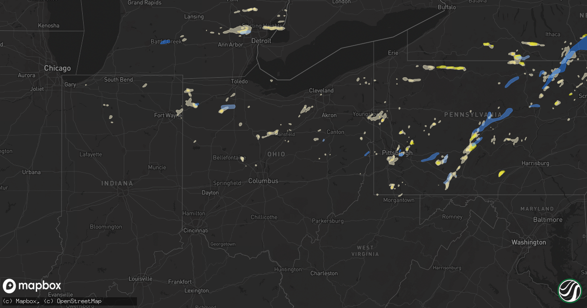
Hail Map in Ohio on July 7, 2021
Get this storm
July 7 map
$229
one time, instant access
Download today. No call, no setup
Keep the $229
Bought the map and want the full workflow? Apply the entire $229 to a subscription within 7 days. None of it is wasted.
Every map, not just this one
This buys you this map. Subscription and you get every map we run, in the markets you choose from a few cities to whole states to nationwide. Plus real-time alerts the moment a storm fires.
Contact data
Name, contact info, occupancy, even credit band for addresses in the footprint. You go from where it hit to who to call.
Become the source they trust
Unlimited branding weather history reports on demand. You already have the documented answer ready for the property owner, and you are the one who showed up with it.
Property data and RoofTrace estimates
Pull up any address you have got, its value and the exact code rules for that jurisdiction, straight from One Click Code. Then RoofTrace estimates the squares, pitch, and roof value, priced the way you price.
Storm reports in Ohio
Ohio
| Date | Description |
|---|---|
| 07/07/20216:10 PM CDT | Multiple trees down near the intersection of laskey and douglas roads. |
| 07/07/20216:10 PM CDT | Tree down on house. |
| 07/07/20216:07 PM CDT | Tree uprooted on tree lawn on bales road. |
| 07/07/20216:07 PM CDT | Tree down in backyard. |
| 07/07/20215:54 PM CDT | Multiple trees reported down in the city of green. |
| 07/07/20215:42 PM CDT | Large limbs downed. |
| 07/07/20215:24 PM CDT | Multiple large tree branches down near the corner of boston road and ridge road on the medina-cuyahoga county line. |
| 07/07/20215:24 PM CDT | Tree down near intersection of nichols and wilbur road. |
| 07/07/20215:18 PM CDT | Semi picked up and tossed on sr 24/cr143. Railroad sign also blown over. |
| 07/07/20215:00 PM CDT | Tree fell on house and car in old brooklyn. |
| 07/07/20214:57 PM CDT | Tree down |
| 07/07/20213:57 PM CDT | Tree down |
| 07/07/20213:54 PM CDT | Highlandview dr. Closed at prouty due to trees and wires down blocking the roadway. |
| 07/07/20213:46 PM CDT | 2 trees and wires down. |
| 07/07/20213:40 PM CDT | Several tree down reported on w 23rd by social media. |
| 07/07/20213:31 PM CDT | Report of tree down along state route 170. Time estimated based on radar. |
| 07/07/20213:10 PM CDT | Trees down on mckean road |
| 07/07/20213:08 PM CDT | Report of a tree down along st route 164 south of lisbon. Time estimated based on radar. |
| 07/07/20213:08 PM CDT | Report of a tree down along st route 164 south of lisbon. Time estimated based on radar. |
| 07/07/20213:00 PM CDT | Corrects time from previous tstm wnd dmg report from 2 e brooklyn. Tree fell on house and car in old brooklyn. |
| 07/07/20212:59 PM CDT | Corrects previous time for tstm wnd dmg report from 2 w newburgh heights. Several tree down 2100 kenneth avenue reported on social media. |
| 07/07/20212:59 PM CDT | Tree down on birch ln reported on social media. |
| 07/07/20212:49 PM CDT | Report of multiple trees down in various parts of the county. Time and location estimated based on radar. |
| 07/07/20212:18 PM CDT | Corrects previous tstm wnd dmg report from 1 w burgoon. Powerlines down on county road 13. |
| 07/07/20212:00 PM CDT | Powerlines down on county road 13. |
| 07/07/20212:00 PM CDT | Tree down on county road 16. |
| 07/07/20211:58 PM CDT | Tree down on wires. Time estimated from radar. |
| 07/07/20211:58 PM CDT | Tree down. Time estimated from radar. |
| 07/07/20211:50 PM CDT | Report from mping: 3-inch tree limbs broken; power poles broken. |
| 07/07/20211:50 PM CDT | Tree uprooted. |
| 07/07/20211:48 PM CDT | Tree down along county road 801. |
| 07/07/20211:42 PM CDT | Tree down on township road 1153. |
| 07/07/20211:42 PM CDT | Tree down along township rd 1153. |
| 07/07/20211:42 PM CDT | 19in diameter tree down. Time estimated by radar. |
| 07/07/20211:41 PM CDT | Corrects previous tstm wnd dmg report from 5 wsw hoytville. Tree down on county road 16. |
| 07/07/20211:33 PM CDT | Utility lines down in wilmot and minor tree damage reported. |
| 07/07/20211:14 PM CDT | Corrects previous tstm wnd dmg report from wilmot. Utility lines down in wilmot and minor tree damage reported. |
| 07/07/20214:15 AM CDT | At 915 PM EDT, a severe thunderstorm was located 8 miles west of St. Clairsville, moving northeast at 35 mph. HAZARD...Wind gusts to 60 mph and quarter-size hail. SOURCE...Radar. IMPACT...Minor hail damage to vehicles is possible. Expect wind damage to trees and power lines, resulting in some power outages. Locations impacted include... Cadiz... Bethesda... Flushing... Adena... Dillonvale... Mount Pleasant... Belmont... Holloway... New Athens... Morristown... Harrisville... Barkcamp State Park...This includes Interstate 70 in Ohio between mile markers 201 and 214. |
| 07/07/20214:04 AM CDT | At 904 PM EDT, a severe thunderstorm was located near West Lafayette, or 8 miles southeast of Coshocton, moving northeast at 35 mph. HAZARD...Wind gusts to 60 mph and quarter-size hail. SOURCE...Radar. IMPACT...Minor hail damage to vehicles is possible. Expect wind damage to trees and power lines, resulting in some power outages. Locations impacted include... Newcomerstown... West Lafayette... Port Washington... Plainfield... Gilmore... Otsego... Boden... Bakersville... Kimbolton... This includes Interstate 77 in Ohio between mile markers 56 and 71. |
| 07/07/20211:39 AM CDT | At 639 PM EDT, a severe thunderstorm was located near Holgate, or 8 miles southeast of Defiance, moving northeast at 30 mph. HAZARD...60 mph wind gusts and quarter size hail. SOURCE...Radar indicated. IMPACT...Hail damage to vehicles is expected. Expect wind damage to roofs, siding, and trees. Locations impacted include... Defiance, Napoleon, Deshler, Liberty Center, Holgate, Mcclure, Hamler, Texas, Malinta, Florida, New Bavaria, Jewell, Gallup, Grelton, Pleasant Bend, Ayersville, Colton, Okolona, Elery and Standley. |
| 07/07/20211:22 AM CDT | At 622 PM EDT, a severe thunderstorm was located over Brunswick, or 7 miles north of Medina, moving east at 20 mph. HAZARD...60 mph wind gusts and quarter size hail. SOURCE...Radar indicated. IMPACT...Minor damage to vehicles is possible. Expect damage to trees and power lines. Locations impacted include... Akron, Medina, Parma, Cuyahoga Falls, Strongsville, Brunswick, North Royalton, Solon, Hudson, Twinsburg, Streetsboro, Macedonia, Stow, Maple Heights, Broadview Heights, Aurora, Brecksville, Bedford, Seven Hills and Bedford Heights. |
| 07/07/202112:54 AM CDT | At 553 PM EDT, severe thunderstorms were located along a line extending from Archbold to Woodburn, moving east at 20 mph. HAZARD...60 mph wind gusts and quarter size hail. SOURCE...Radar indicated. IMPACT...Hail damage to vehicles is expected. Expect wind damage to roofs, siding, and trees. Locations impacted include... Defiance, Napoleon, Wauseon, Archbold, Swanton, Paulding, Delta, Antwerp, Woodburn, Payne, Liberty Center, Ney, Melrose, Florida, Latty, Cecil, Broughton, Evansport, Arthur and Ridgeville Corners.This includes Interstate 80 in Ohio between mile markers 33 and 48. |
| 07/06/202111:59 PM CDT | At 459 PM EDT, a severe thunderstorm was located near Savannah, or 11 miles northwest of Ashland, moving northeast at 25 mph. HAZARD...60 mph wind gusts and penny size hail. SOURCE...Radar indicated. IMPACT...Expect damage to trees and power lines. Locations impacted include... Mansfield, Ashland, Shelby, Ontario, Lexington, Loudonville, New London, Bellville, Plymouth, Hayesville, Savannah, Polk, Sullivan, Greenwich, Butler, Perrysville, Lucas, Jeromesville, Bailey Lakes and Rochester. |
| 07/06/202111:53 PM CDT | At 453 PM EDT, a severe thunderstorm was located near Bryan, moving east at 20 mph. HAZARD...60 mph wind gusts and penny size hail. SOURCE...Radar indicated. IMPACT...Expect damage to roofs, siding, and trees. Locations impacted include... Bryan, Archbold, Montpelier, Edgerton, West Unity, Stryker, West Jefferson, Pulaski, Ney, Blakeslee, Evansport, Pettisville, Zone, Ridgeville Corners, Williams Center, Melbern, Elmira and Hallock.This includes Interstate 80 in Ohio between mile markers 18 and 30. |
| 07/06/202111:40 PM CDT | At 440 PM EDT, a severe thunderstorm was located near Crestline, or 11 miles east of Bucyrus, moving northeast at 20 mph. HAZARD...60 mph wind gusts and quarter size hail. SOURCE...Radar indicated. IMPACT...Minor damage to vehicles is possible. Expect damage to trees and power lines. Locations impacted include... Mansfield, Shelby, Ontario, Crestline, Plymouth, Tiro, Shenandoah and Sulpher Springs. |
| 07/06/202111:21 PM CDT | At 420 PM EDT, a severe thunderstorm was located near East Palestine, moving northeast at 10 mph. HAZARD...Wind gusts to 60 mph. SOURCE...Radar. IMPACT...Expect damage to trees and power lines, resulting in some power outages. Locations impacted include... New Castle... Columbiana... East Palestine... Ellwood City... Oakwood... New Castle Northwest... New Waterford... Big Beaver... New Beaver... Ellport... Bessemer... Plain Grove Township...This includes the following highways... Pennsylvania Turnpike between mile markers 1 and 12. Interstate 376 in Pennsylvania between mile markers 6 and 14. |
| 07/06/202111:16 PM CDT | At 416 PM EDT, a severe thunderstorm was located near Wintersville, or 8 miles west of Steubenville, moving northeast at 15 mph. HAZARD...Wind gusts to 60 mph. SOURCE...Radar. IMPACT...Expect damage to trees and power lines, resulting in some power outages. Locations impacted include... Weirton... Steubenville... Wellsville... Toronto... Wintersville... Mingo Junction... Follansbee... New Cumberland... Smithfield... Richmond... Irondale... New Manchester... |
| 07/06/202110:55 PM CDT | At 355 PM EDT, a severe thunderstorm was located near Lisbon, or 7 miles northwest of Wellsville, moving northeast at 15 mph. HAZARD...Wind gusts to 60 mph. SOURCE...Radar. IMPACT...Expect damage to trees and power lines, resulting in some power outages. Locations impacted include... Calcutta... Lisbon... New Waterford... Rogers... Beaver Creek State Park... Glenmoor... Lake Tomahawk... |
| 07/06/202110:44 PM CDT | At 343 PM EDT, severe thunderstorms were located along a line extending from Lorain to near North Ridgeville to North Royalton, moving northeast at 25 mph. HAZARD...60 mph wind gusts. SOURCE...Radar indicated. IMPACT...Expect damage to trees and power lines. Locations impacted include... Cleveland, Lorain, Elyria, Vermilion, Parma, Lakewood, Euclid, Cleveland Heights, Strongsville, Brunswick, Westlake, North Royalton, North Ridgeville, Solon, Avon Lake, Warrensville Heights, Amherst, Grafton, Highland Hills and North Olmsted. |
| 07/06/202110:15 PM CDT | At 315 PM EDT, a severe thunderstorm was located 7 miles northeast of Fostoria, moving northeast at 20 mph. HAZARD...70 mph wind gusts and quarter size hail. SOURCE...Radar indicated. IMPACT...Minor damage to vehicles is possible. Expect considerable tree damage. Wind damage is also likely to mobile homes, roofs, and outbuildings. Locations impacted include... Fremont, Clyde, Gibsonburg, Woodville, Elmore, Green Springs, Ballville, Bettsville, Risingsun, Lindsey, Helena, Burgoon, Kansas, Stony Prairie and Vickery. |
| 07/06/20219:49 PM CDT | At 249 PM EDT, a severe thunderstorm was located 7 miles southeast of Sugarcreek, or 7 miles southwest of New Philadelphia, moving northeast at 20 mph. HAZARD...Wind gusts to 60 mph. SOURCE...Radar. IMPACT...Expect damage to trees and power lines, resulting in some power outages. Locations impacted include... New Philadelphia... Dover... Uhrichsville... Newcomerstown... Dennison... Sugarcreek... Gnadenhutten... Tuscarawas... Midvale... Mineral City... Port Washington... Barnhill...This includes Interstate 77 in Ohio between mile markers 66 and 86. |
| 07/06/20219:46 PM CDT | At 245 PM EDT, a severe thunderstorm was located near Vanlue, or 11 miles northwest of Upper Sandusky, moving east at 20 mph. HAZARD...70 mph wind gusts and quarter size hail. SOURCE...Radar indicated. IMPACT...Minor damage to vehicles is possible. Expect considerable tree damage. Wind damage is also likely to mobile homes, roofs, and outbuildings. Locations impacted include... Findlay, Tiffin, Fostoria, Upper Sandusky, Forest, Sycamore, Vanlue, New Riegel, Carey, Nevada, Mount Blanchard, Wharton and Bascom. |
| 07/06/20219:43 PM CDT | At 242 PM EDT, a severe thunderstorm was located over Deshler, or 12 miles northeast of Ottawa, moving northeast at 25 mph. HAZARD...60 mph wind gusts and nickel size hail. SOURCE...Radar indicated. IMPACT...Expect damage to roofs, siding, and trees. Locations impacted include... Leipsic, Deshler, Belmore and Gallup. |
| 07/06/20219:39 PM CDT | At 239 PM EDT, a severe thunderstorm was located near Ida, or near Temperance, moving northeast at 20 mph. HAZARD...60 mph wind gusts and penny size hail. SOURCE...Radar indicated. IMPACT...Expect damage to roofs, siding, and trees. This severe thunderstorm will be near... Ida around 250 PM EDT. Luna Pier and Maybee around 300 PM EDT. Monroe around 310 PM EDT.Other locations impacted by this severe thunderstorm include Newport,Samaria, Estral Beach, Toledo Beach, Erie, South Rockwood, WoodlandBeach, Stony Point, La Salle and Bolles Harbor. |
| 07/06/20219:37 PM CDT | At 236 PM EDT, a severe thunderstorm was located near Leipsic, or 10 miles northeast of Ottawa, moving northeast at 25 mph. HAZARD...60 mph wind gusts and nickel size hail. SOURCE...Radar indicated. IMPACT...Expect damage to trees and power lines. Locations impacted include... Bowling Green, Fostoria, North Baltimore, McComb, Weston, Van Buren, Bloomdale, Cygnet, Portage, Jerry City, Hoytville, Custar, West Millgrove, Milton Center and Bairdstown. |
| 07/06/20219:36 PM CDT | At 236 PM EDT, a severe thunderstorm was located over Savannah, or near Ashland, moving east at 20 mph. HAZARD...60 mph wind gusts and nickel size hail. SOURCE...Radar indicated. IMPACT...Expect damage to trees and power lines. Locations impacted include... Ashland, Wellington, Lodi, Creston, West Salem, Chippewa Lake, Savannah, Polk, Sullivan, Seville, Penfield, Westfield Center, Spencer, Gloria Glens Park, Bailey Lakes, Burbank, Congress, Rochester, Rowsburg and Chippewa-On-The-Lake. |
| 07/06/20219:13 PM CDT | At 213 PM EDT, a severe thunderstorm was located near West Lafayette, or 8 miles northeast of Coshocton, moving east at 10 mph. HAZARD...Wind gusts to 60 mph. SOURCE...Radar. IMPACT...Expect damage to trees and power lines, resulting in some power outages. Locations impacted include... Baltic... Stone Creek... Chili... Bakersville...This includes Interstate 77 in Ohio between mile markers 68 and 78. |
| 07/06/20218:45 PM CDT | At 145 PM EDT, severe thunderstorms were located along a line extending from near Orrville to near Mount Eaton to Berlin, moving east at 25 mph. HAZARD...60 mph wind gusts and quarter size hail. SOURCE...Radar indicated. IMPACT...Minor damage to vehicles is possible. Expect damage to trees and power lines. Locations impacted include... Akron, Canton, Wooster, Millersburg, Massillon, Kent, Barberton, Green, Tallmadge, North Canton, Orrville, Berlin, Rittman, Mogadore, Walnut Creek, Doylestown, Hartville, Brewster, Navarre and Dalton. |
| 07/06/20218:15 PM CDT | Tree down on morristown flushing road. Time estimated by radar. |
| 07/06/20218:15 PM CDT | Multiple trees snapped and uprooted. |
| 07/06/20217:19 PM CDT | Several trees down... One of which fell and damaged a house. |
All States Impacted by Hail Map on July 7, 2021
Cities Impacted by Hail Map on July 7, 2021
- Albion, MI
- Springport, MI
- Sarver, PA
- Edgerton, OH
- Bryan, OH
- Warren, PA
- Oxford, MI
- Leonard, MI
- New Milford, CT
- Gaylordsville, CT
- South Kent, CT
- Mansfield, OH
- Crestline, OH
- Bucyrus, OH
- Galion, OH
- Shelby, OH
- Dayton, PA
- Punxsutawney, PA
- Northpoint, PA
- Smicksburg, PA
- Sterling Heights, MI
- Warren, MI
- Harrison Township, MI
- Clinton Township, MI
- Fraser, MI
- Saint Clair Shores, MI
- Harsens Island, MI
- Roseville, MI
- Pulaski, PA
- Hillsville, PA
- Lowellville, OH
- New Wilmington, PA
- New Castle, PA
- New Middletown, OH
- Youngstown, OH
- Campbell, OH
- Edinburg, PA
- Struthers, OH
- Volant, PA
- Bessemer, PA
- Jefferson, PA
- Waynesburg, PA
- Carmichaels, PA
- Middleburgh, NY
- Lutherville Timonium, MD
- Pikesville, MD
- Towson, MD
- Baltimore, MD
- New Albany, PA
- Wyalusing, PA
- Mount Vision, NY
- New Berlin, NY
- Norwich, NY
- South New Berlin, NY
- Mount Upton, NY
- Morris, NY
- Guilford, NY
- New Lisbon, NY
- Enid, OK
- Drummond, OK
- Lahoma, OK
- Snow Shoe, PA
- Clarence, PA
- Newburg, PA
- Shippensburg, PA
- Lurgan, PA
- Orrstown, PA
- Lewistown, MT
- Tyrone, PA
- Hollidaysburg, PA
- Duncansville, PA
- East Freedom, PA
- Portage, PA
- Queen, PA
- Claysburg, PA
- Newry, PA
- Roaring Spring, PA
- Jersey, AR
- Terry, MT
- Covington, PA
- Mansfield, PA
- Mainesburg, PA
- South Weymouth, MA
- Holbrook, MA
- Braintree, MA
- Randolph, MA
- Abington, MA
- Equinunk, PA
- Long Eddy, NY
- Hankins, NY
- Hillsgrove, PA
- Williamsport, PA
- Russell, PA
- Lewis Run, PA
- Bradford, PA
- Addison, NY
- Columbia Cross Roads, PA
- Troy, PA
- Upton, WY
- Moorcroft, WY
- Sturbridge, MA
- Charlton, MA
- Southbridge, MA
- Dudley, MA
- Belmont, NY
- Almond, NY
- Angelica, NY
- Altoona, PA
- Mifflintown, PA
- Pittsburg, MO
- Smethport, PA
- Rew, PA
- Gifford, PA
- South Gibson, PA
- Susquehanna, PA
- Union Dale, PA
- Thompson, PA
- Jackson, PA
- Torrington, WY
- Canton, PA
- Berlin, PA
- Central City, PA
- Vestal, NY
- Owego, NY
- Endicott, NY
- Nichols, NY
- Johnson City, NY
- Rome, PA
- Little Meadows, PA
- Newark Valley, NY
- Apalachin, NY
- Ashland, OH
- Natrona Heights, PA
- Tarentum, PA
- Garrett, PA
- New Florence, PA
- Boswell, PA
- Ligonier, PA
- New Milford, PA
- Pond Creek, OK
- Olivet, MI
- Charlotte, MI
- Warren, MA
- Fairmont, WV
- New Kensington, PA
- Pittsburgh, PA
- Kingsley, PA
- Winchester, VA
- Benton, PA
- Osceola, PA
- New Paris, PA
- Schellsburg, PA
- New Cumberland, WV
- Forksville, PA
- Rensselaerville, NY
- Binghamton, NY
- Tariffville, CT
- Simsbury, CT
- Grass Range, MT
- Holly, MI
- Guys Mills, PA
- New Preston Marble Dale, CT
- Washington Depot, CT
- Nicholson, PA
- Saint Johns, MI
- Elsie, MI
- Ashley, MI
- Bannister, MI
- Perrinton, MI
- Franklin, NY
- Oneonta, NY
- Jefferson, OH
- Rock Creek, OH
- West Mifflin, PA
- Braddock, PA
- East Pittsburgh, PA
- Homestead, PA
- Turtle Creek, PA
- Fairhope, PA
- Nevada, MO
- Walker, MO
- Fredonia, KS
- Forsyth, MT
- Lisbon, OH
- Salineville, OH
- McAlisterville, PA
- Burnham, PA
- Oakland Mills, PA
- Yeagertown, PA
- Richfield, PA
- McClure, PA
- Lewistown, PA
- Reedsville, PA
- Butler, PA
- Saint Clair, MI
- Sullivan, OH
- Homerville, OH
- Spencer, OH
- Barkhamsted, CT
- Cayuta, NY
- Horseheads, NY
- Alum Bank, PA
- Buffalo, KS
- North Branch, NY
- Cochecton, NY
- Swan Lake, NY
- Livingston Manor, NY
- Jeffersonville, NY
- Hortonville, NY
- White Sulphur Springs, NY
- Callicoon, NY
- Damascus, PA
- Youngsville, NY
- Pleasant Hall, PA
- Roxbury, PA
- Pleasant Mount, PA
- Lakewood, PA
- Johnstown, PA
- Burgettstown, PA
- Sugarloaf, PA
- Neversink, NY
- Woodbourne, NY
- Tioga, PA
- Lawrenceville, PA
- Harrison, NE
- Edon, OH
- Montpelier, OH
- Creekside, PA
- Rural Valley, PA
- Shelocta, PA
- Northville, MI
- Lenoxville, PA
- Waymart, PA
- Hop Bottom, PA
- Herrick Center, PA
- Harford, PA
- Forest City, PA
- Roundup, MT
- Winnett, MT
- Leipsic, OH
- Sandisfield, MA
- Moore, MT
- Painted Post, NY
- Cameron Mills, NY
- Woodhull, NY
- Lindley, NY
- Apple Creek, OH
- Fredericksburg, OH
- Beaver Dams, NY
- Millport, NY
- Scio, NY
- Alfred Station, NY
- Andover, NY
- Jay Em, WY
- Red Hook, NY
- Fairmont, OK
- Covington, OK
- East Hartland, CT
- Casco, MI
- Hammond, MT
- Alzada, MT
- Boyes, MT
- Carson City, MI
- Webster, MA
- Bethel Park, PA
- Venetia, PA
- Canonsburg, PA
- Lawrence, PA
- Bridgeville, PA
- Leechburg, PA
- Milanville, PA
- Tyler Hill, PA
- Kenoza Lake, NY
- Dracut, MA
- Methuen, MA
- Pelham, NH
- Andover, MA
- Davenport, NY
- East Meredith, NY
- Beech Creek, PA
- Hannacroix, NY
- Novi, MI
- Tunkhannock, PA
- Westby, MT
- Raymond, MT
- Plentywood, MT
- Miller, SD
- Wessington, SD
- Ulster, PA
- Towanda, PA
- Wysox, PA
- Middle Bass, OH
- Put In Bay, OH
- West Pittsburg, PA
- Wampum, PA
- Campbell, NY
- Savona, NY
- Pine Valley, NY
- Hundred, WV
- New Freeport, PA
- Burton, WV
- Wassaic, NY
- Brookfield, MA
- Granville, MA
- Southwick, MA
- North Granby, CT
- Avon, MA
- Weymouth, MA
- Rockland, MA
- Deshler, OH
- Nemacolin, PA
- Greensboro, PA
- Granville Summit, PA
- Hilger, MT
- Monroeton, PA
- State College, PA
- Uniontown, PA
- Winsted, CT
- Oliveburg, PA
- Winfield, KS
- Grand Valley, PA
- Titusville, PA
- Glenshaw, PA
- Goshen, IN
- Topeka, IN
- Shipshewana, IN
- Millersburg, IN
- Kewanna, IN
- Rochester, IN
- Algonac, MI
- Fostoria, OH
- Kansas, OH
- New Philadelphia, OH
- Warrensburg, IL
- Maroa, IL
- Litchfield, OH
- Grafton, OH
- Hollsopple, PA
- Cheyenne, OK
- Philipsburg, PA
- Farmington, MI
- Huntingdon, PA
- Ellenville, NY
- Napanoch, NY
- Grahamsville, NY
- Lower Brule, SD
- Kingston, NY
- Cottekill, NY
- Hurley, NY
- Petersburg, PA
- Walled Lake, MI
- South Lyon, MI
- Wixom, MI
- West Bloomfield, MI
- Summit, NY
- Richmondville, NY
- Fultonham, NY
- Warnerville, NY
- Schoharie, NY
- Weston, OH
- Osceola, MO
- Marysville, OH
- Raymond, OH
- Claryville, NY
- Coeymans Hollow, NY
- Westerlo, NY
- Greenville, NY
- McDonald, PA
- Great Barrington, MA
- Sheffield, MA
- Nelson, PA
- Knoxville, PA
- Jasper, NY
- Middlebury Center, PA
- Elkland, PA
- Fenelton, PA
- Chicora, PA
- Saugerties, NY
- North Grosvenordale, CT
- Monroeville, IN
- Cecil, OH
- Sherwood, OH
- Defiance, OH
- Lisle, NY
- Berkshire, NY
- Galeton, PA
- Hudson, NY
- Cocolamus, PA
- Lucas, OH
- Bellville, OH
- Youngsville, PA
- Sugar Grove, PA
- Factoryville, PA
- Woodburn, IN
- Harlan, IN
- Antwerp, OH
- New Haven, IN
- Orrville, OH
- Dalton, OH
- Coventry, CT
- Columbia, CT
- Montoursville, PA
- Powell, OH
- Ostrander, OH
- Delaware, OH
- Dorset, OH
- Andover, OH
- Howell, MI
- Douglas, MA
- Zortman, MT
- Roy, MT
- Berne, NY
- Marion, OH
- Evans, WA
- Otego, NY
- Unadilla, NY
- Rileyville, VA
- Luray, VA
- Caledonia, OH
- Centerville, PA
- Tidioute, PA
- Coxsackie, NY
- Athens, NY
- Catskill, NY
- McComb, OH
- Custar, OH
- Hoytville, OH
- Holliston, MA
- Staunton, VA
- Bellwood, PA
- Valley City, OH
- Brunswick, OH
- Townville, PA
- Davis, WV
- Linesville, PA
- Uxbridge, MA
- Normantown, WV
- Glenville, WV
- Cedarville, WV
- Knox, IN
- Bloomville, NY
- West Mansfield, OH
- Hyde Park, NY
- Poughkeepsie, NY
- Highland, NY
- Rome, OH
- Prompton, PA
- Honesdale, PA
- Hammon, OK
- The Colony, TX
- Feura Bush, NY
- Climax, NY
- West Coxsackie, NY
- Alcove, NY
- Clarksville, NY
- Selkirk, NY
- Delmar, NY
- East Berne, NY
- Ravena, NY
- Bellefonte, PA
- Allison Park, PA
- Verona, PA
- Medford, OK
- Kremlin, OK
- Nash, OK
- Kitzmiller, MD
- Pinckney, MI
- Olivebridge, NY
- Frenchville, PA
- East Granby, CT
- West Granby, CT
- Granby, CT
- West Hartland, CT
- Riverton, CT
- Colebrook, CT
- West Suffield, CT
- Warren Center, PA
- Brackney, PA
- Pawling, NY
- Wingdale, NY
- Sherman, CT
- Stone Ridge, NY
- Springville, PA
- Montrose, PA
- Cairnbrook, PA
- East China, MI
- Brimfield, MA
- Corry, PA
- Columbus, PA
- Osterburg, PA
- Mount Storm, WV
- Elk Garden, WV
- Dansville, MI
- Broadway, VA
- Stockbridge, MI
- Gregory, MI
- Mark Center, OH
- Hicksville, OH
- Lanse, PA
- Millerstown, PA
- Stuyvesant, NY
- Stuyvesant Falls, NY
- Ghent, NY
- Kinderhook, NY
- Earlton, NY
- Morgantown, WV
- Pursglove, WV
- Cedar Vale, KS
- Lumberton, NC
- Cuddy, PA
- Cecil, PA
- Cabot, PA
- Saxonburg, PA
- Parksville, NY
- Loch Sheldrake, NY
- Liberty, NY
- Ferndale, NY
- Hurleyville, NY
- Timberville, VA
- Bronson, KS
- Lake Lynn, PA
- Point Marion, PA
- Maidsville, WV
- Linn, WV
- Alum Bridge, WV
- Muncy Valley, PA
- Carbondale, PA
- Mount Blanchard, OH
- Carey, OH
- Vanlue, OH
- Wharton, OH
- Fairview, OK
- Franklin, MI
- Milford, MI
- Hamburg, MI
- Brighton, MI
- Southfield, MI
- Whitmore Lake, MI
- Bloomfield Hills, MI
- Commerce Township, MI
- New Hudson, MI
- Livonia, MI
- Davenport, IA
- Walcott, IA
- Kittanning, PA
- Candor, NY
- Lagrange, OH
- Wellington, OH
- Medina, OH
- Imler, PA
- Maurertown, VA
- Nevada, OH
- Harrisville, PA
- West Oneonta, NY
- Celina, OH
- Mendon, OH
- Cross Junction, VA
- Longton, KS
- Elk City, KS
- Jermyn, PA
- Olyphant, PA
- Warsaw, MO
- Lincoln, MO
- Slippery Rock, PA
- Tipton, PA
- Port Matilda, PA
- Bridgeport, OH
- New Bethlehem, PA
- Whitney Point, NY
- Smithville Flats, NY
- Greene, NY
- Hancock, NY
- Stone Creek, OH
- Fresno, OH
- Dexter, KS
- Millville, PA
- Ringgold, PA
- Worthville, PA
- Mayport, PA
- Sprankle Mills, PA
- Roscoe, NY
- Fremont Center, NY
- Staatsburg, NY
- Dallas, PA
- Mercer, PA
- Fredonia, PA
- Sugar Run, PA
- Millersburg, OH
- Mount Morris, PA
- Ortonville, MI
- Kerhonkson, NY
- Accord, NY
- West Shokan, NY
- Irvine, PA
- Pittsfield, PA
- Chesterton, IN
- Westville, IN
- Shiloh, OH
- Noxen, PA
- Mineral Point, PA
- Parkhill, PA
- Independence, OH
- Cleveland, OH
- Stoughton, MA
- East Weymouth, MA
- Quincy, MA
- Dedham, MA
- Milton, MA
- Westwood, MA
- Norwood, MA
- Dover, MA
- Canton, MA
- Eldridge, IA
- Windsor, CT
- Windsor Locks, CT
- Rosedale, WV
- Gassaway, WV
- Culver, IN
- Hamilton, PA
- Milroy, PA
- Bowling Green, OH
- Lawrence, MA
- Laurens, NY
- New Salem, PA
- Ware, MA
- West Brookfield, MA
- West Warren, MA
- Colchester, CT
- Lebanon, CT
- South Park, PA
- Carnegie, PA
- Eighty Four, PA
- Presto, PA
- Morgan, PA
- Finleyville, PA
- Oakdale, PA
- Oldtown, MD
- Flintstone, MD
- Hysham, MT
- Friedens, PA
- Spruce Creek, PA
- Warriors Mark, PA
- Howard, PA
- Mill Hall, PA
- Sandy Ridge, PA
- Blanchard, PA
- Osceola Mills, PA
- Lock Haven, PA
- Karthaus, PA
- Julian, PA
- Morris, PA
- Gaines, PA
- Wellsboro, PA
- Loyalhanna, PA
- Blairsville, PA
- Robinson, PA
- Bolivar, PA
- Bradenville, PA
- Latrobe, PA
- Derry, PA
- Afton, NY
- Shunk, PA
- Bainbridge, NY
- Oxford, NY
- Port Crane, NY
- Castle Creek, NY
- Chenango Forks, NY
- Harpursville, NY
- Glen Aubrey, NY
- Le Raysville, PA
- Maine, NY
- Muncy, PA
- Canton, CT
- Wethersfield, CT
- East Hartford, CT
- Glastonbury, CT
- Burlington, CT
- West Hartford, CT
- Hartford, CT
- Avon, CT
- Farmington, CT
- Suffield, CT
- Tolland, CT
- South Windsor, CT
- Bloomfield, CT
- Ellington, CT
- Broad Brook, CT
- West Simsbury, CT
- Enfield, CT
- East Windsor, CT
- Stafford Springs, CT
- Somers, CT
- Belgrade, MT
- Bozeman, MT
- Garryowen, MT
- Billings, MT
- Saint Xavier, MT
- Laurel, MT
- Broadview, MT
- Big Timber, MT
- Acton, MT
- Busby, MT
- Hardin, MT
- Ryegate, MT
- Rapelje, MT
- Ballantine, MT
- Huntley, MT
- Molt, MT
- Crow Agency, MT
- Pompeys Pillar, MT
- Lodge Grass, MT
- Lavina, MT
- Rosebud, MT
- Powderville, MT
- Ismay, MT
- Volborg, MT
- Biddle, MT
- Ekalaka, MT
- Philmont, NY
- Hillsdale, NY
- Housatonic, MA
- New Baltimore, NY
- South Egremont, MA
- Chatham, NY
- Valatie, NY
- West Stockbridge, MA
- Coeymans, NY
- Schodack Landing, NY
- South Kortright, NY
- Stamford, NY
- Harpersfield, NY
- Hobart, NY
- Jefferson, NY
- North Blenheim, NY
- West Fulton, NY
- Pine City, NY
- Corning, NY
- Pine Ridge, SD
- Hingham, MA
- Williamsburg, PA
- Apollo, PA
- Vandergrift, PA
- McDonough, NY
- Beach City, OH
- Wilmot, OH
- Dundee, OH
- Cygnet, OH
- North Baltimore, OH
- Rudolph, OH
- Toronto, OH
- Steubenville, OH
- Van Tassell, WY
- Lusk, WY
- Merriman, NE
- Battle Creek, MI


