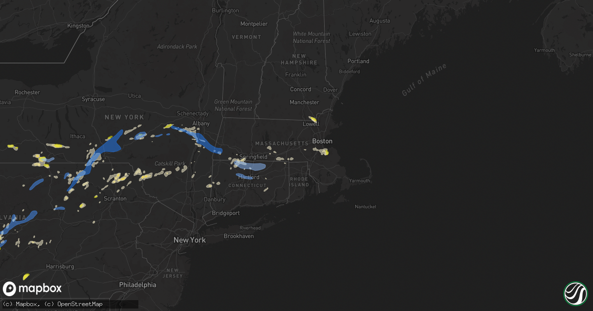
Hail Map in Massachusetts on July 7, 2021
Get this storm
July 7 map
$229
one time, instant access
Download today. No call, no setup
Keep the $229
Bought the map and want the full workflow? Apply the entire $229 to a subscription within 7 days. None of it is wasted.
Every map, not just this one
This buys you this map. Subscription and you get every map we run, in the markets you choose from a few cities to whole states to nationwide. Plus real-time alerts the moment a storm fires.
Contact data
Name, contact info, occupancy, even credit band for addresses in the footprint. You go from where it hit to who to call.
Become the source they trust
Unlimited branding weather history reports on demand. You already have the documented answer ready for the property owner, and you are the one who showed up with it.
Property data and RoofTrace estimates
Pull up any address you have got, its value and the exact code rules for that jurisdiction, straight from One Click Code. Then RoofTrace estimates the squares, pitch, and roof value, priced the way you price.
Storm reports in Massachusetts
Massachusetts
| Date | Description |
|---|---|
| 07/07/20216:55 PM CDT | Tree down blocking high street |
| 07/07/20216:50 PM CDT | A local report indicates 1.00 inch wind near WEYMOUTH |
| 07/07/20216:50 PM CDT | Tree and wires down west lake drive |
| 07/07/20216:50 PM CDT | Tree down on pond street |
| 07/07/20216:35 PM CDT | Trees down on on river street and pine street |
| 07/07/20216:25 PM CDT | Trees and wires down on lancaster road |
| 07/07/20216:17 PM CDT | Multiple trees down on farm street |
| 07/07/20216:17 PM CDT | A local report indicates 75 MPH wind near BLUE HILL COOP |
| 07/07/20216:00 PM CDT | Trees and wires down on north mill street... Also tree down on tractor trailer on lumber street |
| 07/07/20215:29 PM CDT | A local report indicates 60 MPH wind near WEBSTER |
| 07/07/20214:50 PM CDT | Trees and wires on long hill road |
| 07/07/20214:00 PM CDT | Tree and power lines down on leonard ave |
| 07/07/20213:50 PM CDT | Trees and wires down on spring steel street and on easthampton road |
| 07/07/20213:47 PM CDT | A local report indicates 1.00 inch wind near METHUEN |
| 07/07/20213:47 PM CDT | Tree and wires down on spring road and on tyler street. |
| 07/07/20213:15 PM CDT | Tree down leaning on wires on new marlborough hill road |
| 07/07/20213:03 PM CDT | A tree was downed onto wires on baldwin hill road south at townhouse hill road |
| 07/07/20212:32 PM CDT | A tree was downed on wires on north main street in lanesborough |
| 07/07/20212:55 AM CDT | Tree down on holbrook steet at cleveland street |
| 07/07/20212:47 AM CDT | At 746 PM EDT, a severe thunderstorm was located over Rockland, or near Weymouth, moving east at 20 mph. HAZARD...70 mph wind gusts and quarter size hail. SOURCE...Radar indicated and trained spotters. This storm has a history of producing numerous downed trees in Dedham, Canton and Dover. IMPACT...Expect considerable damage to trees and power lines. Wind damage is also likely to mobile homes, roofs, and outbuildings. Minor hail damage to vehicles is possible. Locations impacted include... Brockton, Weymouth, Braintree, Marshfield, Hingham, Scituate, Pembroke, Rockland, Abington, Duxbury, Whitman, Hanover, East Bridgewater, Kingston, Holbrook, Norwell, Hanson, Cohasset and Halifax. |
| 07/07/20211:59 AM CDT | At 659 PM EDT, a severe thunderstorm was located over Medfield, or near Norwood, moving east at 10 mph. HAZARD...60 mph wind gusts and nickel size hail. SOURCE...Radar indicated. IMPACT...Expect damage to trees and power lines. Locations impacted include... Boston, Brockton, Quincy, Newton, Framingham, Brookline, Weymouth, Braintree, Natick, Randolph, Franklin, Needham, Norwood, Wellesley, Milton, Stoughton, Dedham, Walpole, Mansfield and Easton. |
| 07/07/20211:48 AM CDT | At 647 PM EDT, a severe thunderstorm was located over Averill Park, or 10 miles northeast of Nassau, moving east at 30 mph. HAZARD...60 mph wind gusts and quarter size hail. SOURCE...Radar indicated. IMPACT...Hail damage to vehicles is expected. Expect wind damage to roofs, siding, and trees. Locations impacted include... North Adams, Adams, Williamstown, Cheshire, Stephentown, Berlin, Florida, Hancock, Savoy, New Ashford, West Sand Lake, Averill Park, Brunswick, Sand Lake, Poestenkill, East Nassau, Hairpin Turn, Greylock, Soldiers Memorial Field and West Stephentown. |
| 07/07/20211:18 AM CDT | At 617 PM EDT, a severe thunderstorm was located over West Boylston, or near Shrewsbury, moving east at 15 mph. HAZARD...60 mph wind gusts and penny size hail. SOURCE...Radar indicated. IMPACT...Expect damage to trees and power lines. Locations impacted include... Worcester, Framingham, Leominster, Marlborough, Shrewsbury, Westford, Acton, Hudson, Westborough, Concord, Sudbury, Holden, Northborough, Clinton, Wayland, Groton, Maynard, Southborough, Littleton and Lancaster. |
| 07/07/202112:23 AM CDT | At 523 PM EDT, a severe thunderstorm was located over Ancram, or 15 miles east of Saugerties, moving east at 30 mph. HAZARD...60 mph wind gusts and penny size hail. SOURCE...Radar indicated. IMPACT...Expect damage to roofs, siding, and trees. Locations impacted include... Torrington, New Hartford, Copake, Sheffield, Pine Plains, Norfolk, Ancram, Canaan, Millerton, Northwest Harwinton, New Hartford Center, Ashley Falls, Falls Village, Winsted, Harwinton, Bethel, Barkhamsted, Salisbury, Goshen and Hillsdale. |
| 07/07/202112:21 AM CDT | At 521 PM EDT, a severe thunderstorm was located over West Brookfield, or 18 miles southeast of Amherst, moving east at 15 mph. HAZARD...60 mph wind gusts and quarter size hail. SOURCE...Radar indicated. IMPACT...Expect wind damage to trees and power lines. Minor hail damage to vehicles is possible. Locations impacted include... Worcester, Holden, Auburn, Oxford, Charlton, Palmer, Spencer, Leicester, Ware, Sturbridge, Rutland, Barre, Warren, Paxton, North Brookfield, West Brookfield, Brimfield, Princeton, Brookfield and Hardwick. |
| 07/06/202111:50 PM CDT | At 450 PM EDT, a severe thunderstorm was located near Hartland, or 13 miles northeast of Torrington, moving southeast at 30 mph. HAZARD...60 mph wind gusts and quarter size hail. SOURCE...Radar indicated. IMPACT...Expect wind damage to trees and power lines. Minor hail damage to vehicles is possible. Locations impacted include... Hartford, West Hartford, Manchester, East Hartford, Enfield, Glastonbury, Newington, Windsor, Wethersfield, South Windsor, Simsbury, Bloomfield, Rocky Hill, Avon, Suffield, Ellington, Windsor Locks, Granby, East Windsor and Canton. |
| 07/06/202111:44 PM CDT | At 443 PM EDT, a severe thunderstorm was located over Ancram, or 16 miles northeast of Rhinebeck, moving east at 35 mph. HAZARD...60 mph wind gusts and penny size hail. SOURCE...Radar indicated. IMPACT...Expect damage to roofs, siding, and trees. Locations impacted include... Sharon, Pine Plains, Ancram, Millerton, Falls Village, Bethel, Salisbury, Goshen, Cornwall, South Norfolk, Pachin Mills, Ancramdale, South Canaan, Kelly Corner, West Goshen, Shekomeko, Silvernails, Pulvers Corners, Amesville and Spaulding Furnace. |
| 07/06/202111:36 PM CDT | At 435 PM EDT, a severe thunderstorm was located over Pelham, or near Salem, moving southeast at 40 mph. HAZARD...60 mph wind gusts and half dollar size hail. SOURCE...Radar indicated. IMPACT...Hail damage to vehicles is expected. Expect wind damage to roofs, siding, and trees. Locations impacted include... Salem, Pelham, Atkinson and Windham. This includes Interstate 93 between mile markers 1 and 5. |
| 07/06/202111:16 PM CDT | At 416 PM EDT, a severe thunderstorm was located over Sandisfield, or 13 miles southeast of Great Barrington, moving east at 35 mph. HAZARD...60 mph wind gusts and penny size hail. SOURCE...Radar indicated. IMPACT...Expect damage to roofs, siding, and trees. Locations impacted include... Great Barrington, Sheffield, Norfolk, Otis, Canaan, Sandisfield, Housatonic, Ashley Falls, Winsted, Barkhamsted, Stockbridge, New Marlborough, Colebrook, Monterey, Tyringham, Sodom, Hartsville, Konkapot, Wangum Village and Gomorrah. |
| 07/06/202111:01 PM CDT | At 401 PM EDT, a severe thunderstorm was located over East Windsor, or 12 miles east of Pittsfield, moving east at 20 mph. HAZARD...60 mph wind gusts and quarter size hail. SOURCE...Radar indicated. IMPACT...Expect wind damage to trees and power lines. Minor hail damage to vehicles is possible. Locations impacted include... Amherst, Northampton, Deerfield, South Hadley, Montague, Granby, Hadley, Sunderland, Hatfield, Williamsburg, Huntington, Conway, Leverett, Shutesbury, Ashfield, Westhampton, Whately, Chesterfield, Worthington and Goshen. |
| 07/06/202111:00 PM CDT | At 359 PM EDT, a severe thunderstorm was located over East Windsor, or 12 miles east of Pittsfield, moving east at 25 mph. HAZARD...60 mph wind gusts and quarter size hail. SOURCE...Radar indicated. IMPACT...Hail damage to vehicles is expected. Expect wind damage to roofs, siding, and trees. Locations impacted include... Savoy, Hinsdale, Windsor, Peru and Brier. |
| 07/06/202110:38 PM CDT | At 338 PM EDT, a severe thunderstorm was located over Great Barrington, moving east at 15 mph. HAZARD...60 mph wind gusts and penny size hail. SOURCE...Radar indicated. IMPACT...Expect damage to roofs, siding, and trees. Locations impacted include... Great Barrington, Sheffield, Otis, Sandisfield, Housatonic, Ashley Falls, Stockbridge, New Marlborough, Monterey, Alford, Tyringham, Hartsville, Konkapot, Gomorrah, New Boston, North Otis, Newsboy Statue, Montville, Glendale and Williamsville. |
| 07/06/202110:27 PM CDT | At 327 PM EDT, a severe thunderstorm was located near New Ashford, or 7 miles north of Pittsfield, moving east at 25 mph. HAZARD...60 mph wind gusts and penny size hail. SOURCE...Radar indicated. IMPACT...Expect damage to roofs, siding, and trees. Locations impacted include... Pittsfield, Adams, Cheshire, Hancock, Savoy, New Ashford, Berkshire, Dalton, Lanesborough, Hinsdale, Windsor, Peru, Soldiers Memorial Field, North Hancock, Cheshire Harbor, Arnoldville, Town Crest Village, Lakeview Terrace, Maple Grove and The Boulders. |
All States Impacted by Hail Map on July 7, 2021
Cities Impacted by Hail Map on July 7, 2021
- Albion, MI
- Springport, MI
- Sarver, PA
- Edgerton, OH
- Bryan, OH
- Warren, PA
- Oxford, MI
- Leonard, MI
- New Milford, CT
- Gaylordsville, CT
- South Kent, CT
- Mansfield, OH
- Crestline, OH
- Bucyrus, OH
- Galion, OH
- Shelby, OH
- Dayton, PA
- Punxsutawney, PA
- Northpoint, PA
- Smicksburg, PA
- Sterling Heights, MI
- Warren, MI
- Harrison Township, MI
- Clinton Township, MI
- Fraser, MI
- Saint Clair Shores, MI
- Harsens Island, MI
- Roseville, MI
- Pulaski, PA
- Hillsville, PA
- Lowellville, OH
- New Wilmington, PA
- New Castle, PA
- New Middletown, OH
- Youngstown, OH
- Campbell, OH
- Edinburg, PA
- Struthers, OH
- Volant, PA
- Bessemer, PA
- Jefferson, PA
- Waynesburg, PA
- Carmichaels, PA
- Middleburgh, NY
- Lutherville Timonium, MD
- Pikesville, MD
- Towson, MD
- Baltimore, MD
- New Albany, PA
- Wyalusing, PA
- Mount Vision, NY
- New Berlin, NY
- Norwich, NY
- South New Berlin, NY
- Mount Upton, NY
- Morris, NY
- Guilford, NY
- New Lisbon, NY
- Enid, OK
- Drummond, OK
- Lahoma, OK
- Snow Shoe, PA
- Clarence, PA
- Newburg, PA
- Shippensburg, PA
- Lurgan, PA
- Orrstown, PA
- Lewistown, MT
- Tyrone, PA
- Hollidaysburg, PA
- Duncansville, PA
- East Freedom, PA
- Portage, PA
- Queen, PA
- Claysburg, PA
- Newry, PA
- Roaring Spring, PA
- Jersey, AR
- Terry, MT
- Covington, PA
- Mansfield, PA
- Mainesburg, PA
- South Weymouth, MA
- Holbrook, MA
- Braintree, MA
- Randolph, MA
- Abington, MA
- Equinunk, PA
- Long Eddy, NY
- Hankins, NY
- Hillsgrove, PA
- Williamsport, PA
- Russell, PA
- Lewis Run, PA
- Bradford, PA
- Addison, NY
- Columbia Cross Roads, PA
- Troy, PA
- Upton, WY
- Moorcroft, WY
- Sturbridge, MA
- Charlton, MA
- Southbridge, MA
- Dudley, MA
- Belmont, NY
- Almond, NY
- Angelica, NY
- Altoona, PA
- Mifflintown, PA
- Pittsburg, MO
- Smethport, PA
- Rew, PA
- Gifford, PA
- South Gibson, PA
- Susquehanna, PA
- Union Dale, PA
- Thompson, PA
- Jackson, PA
- Torrington, WY
- Canton, PA
- Berlin, PA
- Central City, PA
- Vestal, NY
- Owego, NY
- Endicott, NY
- Nichols, NY
- Johnson City, NY
- Rome, PA
- Little Meadows, PA
- Newark Valley, NY
- Apalachin, NY
- Ashland, OH
- Natrona Heights, PA
- Tarentum, PA
- Garrett, PA
- New Florence, PA
- Boswell, PA
- Ligonier, PA
- New Milford, PA
- Pond Creek, OK
- Olivet, MI
- Charlotte, MI
- Warren, MA
- Fairmont, WV
- New Kensington, PA
- Pittsburgh, PA
- Kingsley, PA
- Winchester, VA
- Benton, PA
- Osceola, PA
- New Paris, PA
- Schellsburg, PA
- New Cumberland, WV
- Forksville, PA
- Rensselaerville, NY
- Binghamton, NY
- Tariffville, CT
- Simsbury, CT
- Grass Range, MT
- Holly, MI
- Guys Mills, PA
- New Preston Marble Dale, CT
- Washington Depot, CT
- Nicholson, PA
- Saint Johns, MI
- Elsie, MI
- Ashley, MI
- Bannister, MI
- Perrinton, MI
- Franklin, NY
- Oneonta, NY
- Jefferson, OH
- Rock Creek, OH
- West Mifflin, PA
- Braddock, PA
- East Pittsburgh, PA
- Homestead, PA
- Turtle Creek, PA
- Fairhope, PA
- Nevada, MO
- Walker, MO
- Fredonia, KS
- Forsyth, MT
- Lisbon, OH
- Salineville, OH
- McAlisterville, PA
- Burnham, PA
- Oakland Mills, PA
- Yeagertown, PA
- Richfield, PA
- McClure, PA
- Lewistown, PA
- Reedsville, PA
- Butler, PA
- Saint Clair, MI
- Sullivan, OH
- Homerville, OH
- Spencer, OH
- Barkhamsted, CT
- Cayuta, NY
- Horseheads, NY
- Alum Bank, PA
- Buffalo, KS
- North Branch, NY
- Cochecton, NY
- Swan Lake, NY
- Livingston Manor, NY
- Jeffersonville, NY
- Hortonville, NY
- White Sulphur Springs, NY
- Callicoon, NY
- Damascus, PA
- Youngsville, NY
- Pleasant Hall, PA
- Roxbury, PA
- Pleasant Mount, PA
- Lakewood, PA
- Johnstown, PA
- Burgettstown, PA
- Sugarloaf, PA
- Neversink, NY
- Woodbourne, NY
- Tioga, PA
- Lawrenceville, PA
- Harrison, NE
- Edon, OH
- Montpelier, OH
- Creekside, PA
- Rural Valley, PA
- Shelocta, PA
- Northville, MI
- Lenoxville, PA
- Waymart, PA
- Hop Bottom, PA
- Herrick Center, PA
- Harford, PA
- Forest City, PA
- Roundup, MT
- Winnett, MT
- Leipsic, OH
- Sandisfield, MA
- Moore, MT
- Painted Post, NY
- Cameron Mills, NY
- Woodhull, NY
- Lindley, NY
- Apple Creek, OH
- Fredericksburg, OH
- Beaver Dams, NY
- Millport, NY
- Scio, NY
- Alfred Station, NY
- Andover, NY
- Jay Em, WY
- Red Hook, NY
- Fairmont, OK
- Covington, OK
- East Hartland, CT
- Casco, MI
- Hammond, MT
- Alzada, MT
- Boyes, MT
- Carson City, MI
- Webster, MA
- Bethel Park, PA
- Venetia, PA
- Canonsburg, PA
- Lawrence, PA
- Bridgeville, PA
- Leechburg, PA
- Milanville, PA
- Tyler Hill, PA
- Kenoza Lake, NY
- Dracut, MA
- Methuen, MA
- Pelham, NH
- Andover, MA
- Davenport, NY
- East Meredith, NY
- Beech Creek, PA
- Hannacroix, NY
- Novi, MI
- Tunkhannock, PA
- Westby, MT
- Raymond, MT
- Plentywood, MT
- Miller, SD
- Wessington, SD
- Ulster, PA
- Towanda, PA
- Wysox, PA
- Middle Bass, OH
- Put In Bay, OH
- West Pittsburg, PA
- Wampum, PA
- Campbell, NY
- Savona, NY
- Pine Valley, NY
- Hundred, WV
- New Freeport, PA
- Burton, WV
- Wassaic, NY
- Brookfield, MA
- Granville, MA
- Southwick, MA
- North Granby, CT
- Avon, MA
- Weymouth, MA
- Rockland, MA
- Deshler, OH
- Nemacolin, PA
- Greensboro, PA
- Granville Summit, PA
- Hilger, MT
- Monroeton, PA
- State College, PA
- Uniontown, PA
- Winsted, CT
- Oliveburg, PA
- Winfield, KS
- Grand Valley, PA
- Titusville, PA
- Glenshaw, PA
- Goshen, IN
- Topeka, IN
- Shipshewana, IN
- Millersburg, IN
- Kewanna, IN
- Rochester, IN
- Algonac, MI
- Fostoria, OH
- Kansas, OH
- New Philadelphia, OH
- Warrensburg, IL
- Maroa, IL
- Litchfield, OH
- Grafton, OH
- Hollsopple, PA
- Cheyenne, OK
- Philipsburg, PA
- Farmington, MI
- Huntingdon, PA
- Ellenville, NY
- Napanoch, NY
- Grahamsville, NY
- Lower Brule, SD
- Kingston, NY
- Cottekill, NY
- Hurley, NY
- Petersburg, PA
- Walled Lake, MI
- South Lyon, MI
- Wixom, MI
- West Bloomfield, MI
- Summit, NY
- Richmondville, NY
- Fultonham, NY
- Warnerville, NY
- Schoharie, NY
- Weston, OH
- Osceola, MO
- Marysville, OH
- Raymond, OH
- Claryville, NY
- Coeymans Hollow, NY
- Westerlo, NY
- Greenville, NY
- McDonald, PA
- Great Barrington, MA
- Sheffield, MA
- Nelson, PA
- Knoxville, PA
- Jasper, NY
- Middlebury Center, PA
- Elkland, PA
- Fenelton, PA
- Chicora, PA
- Saugerties, NY
- North Grosvenordale, CT
- Monroeville, IN
- Cecil, OH
- Sherwood, OH
- Defiance, OH
- Lisle, NY
- Berkshire, NY
- Galeton, PA
- Hudson, NY
- Cocolamus, PA
- Lucas, OH
- Bellville, OH
- Youngsville, PA
- Sugar Grove, PA
- Factoryville, PA
- Woodburn, IN
- Harlan, IN
- Antwerp, OH
- New Haven, IN
- Orrville, OH
- Dalton, OH
- Coventry, CT
- Columbia, CT
- Montoursville, PA
- Powell, OH
- Ostrander, OH
- Delaware, OH
- Dorset, OH
- Andover, OH
- Howell, MI
- Douglas, MA
- Zortman, MT
- Roy, MT
- Berne, NY
- Marion, OH
- Evans, WA
- Otego, NY
- Unadilla, NY
- Rileyville, VA
- Luray, VA
- Caledonia, OH
- Centerville, PA
- Tidioute, PA
- Coxsackie, NY
- Athens, NY
- Catskill, NY
- McComb, OH
- Custar, OH
- Hoytville, OH
- Holliston, MA
- Staunton, VA
- Bellwood, PA
- Valley City, OH
- Brunswick, OH
- Townville, PA
- Davis, WV
- Linesville, PA
- Uxbridge, MA
- Normantown, WV
- Glenville, WV
- Cedarville, WV
- Knox, IN
- Bloomville, NY
- West Mansfield, OH
- Hyde Park, NY
- Poughkeepsie, NY
- Highland, NY
- Rome, OH
- Prompton, PA
- Honesdale, PA
- Hammon, OK
- The Colony, TX
- Feura Bush, NY
- Climax, NY
- West Coxsackie, NY
- Alcove, NY
- Clarksville, NY
- Selkirk, NY
- Delmar, NY
- East Berne, NY
- Ravena, NY
- Bellefonte, PA
- Allison Park, PA
- Verona, PA
- Medford, OK
- Kremlin, OK
- Nash, OK
- Kitzmiller, MD
- Pinckney, MI
- Olivebridge, NY
- Frenchville, PA
- East Granby, CT
- West Granby, CT
- Granby, CT
- West Hartland, CT
- Riverton, CT
- Colebrook, CT
- West Suffield, CT
- Warren Center, PA
- Brackney, PA
- Pawling, NY
- Wingdale, NY
- Sherman, CT
- Stone Ridge, NY
- Springville, PA
- Montrose, PA
- Cairnbrook, PA
- East China, MI
- Brimfield, MA
- Corry, PA
- Columbus, PA
- Osterburg, PA
- Mount Storm, WV
- Elk Garden, WV
- Dansville, MI
- Broadway, VA
- Stockbridge, MI
- Gregory, MI
- Mark Center, OH
- Hicksville, OH
- Lanse, PA
- Millerstown, PA
- Stuyvesant, NY
- Stuyvesant Falls, NY
- Ghent, NY
- Kinderhook, NY
- Earlton, NY
- Morgantown, WV
- Pursglove, WV
- Cedar Vale, KS
- Lumberton, NC
- Cuddy, PA
- Cecil, PA
- Cabot, PA
- Saxonburg, PA
- Parksville, NY
- Loch Sheldrake, NY
- Liberty, NY
- Ferndale, NY
- Hurleyville, NY
- Timberville, VA
- Bronson, KS
- Lake Lynn, PA
- Point Marion, PA
- Maidsville, WV
- Linn, WV
- Alum Bridge, WV
- Muncy Valley, PA
- Carbondale, PA
- Mount Blanchard, OH
- Carey, OH
- Vanlue, OH
- Wharton, OH
- Fairview, OK
- Franklin, MI
- Milford, MI
- Hamburg, MI
- Brighton, MI
- Southfield, MI
- Whitmore Lake, MI
- Bloomfield Hills, MI
- Commerce Township, MI
- New Hudson, MI
- Livonia, MI
- Davenport, IA
- Walcott, IA
- Kittanning, PA
- Candor, NY
- Lagrange, OH
- Wellington, OH
- Medina, OH
- Imler, PA
- Maurertown, VA
- Nevada, OH
- Harrisville, PA
- West Oneonta, NY
- Celina, OH
- Mendon, OH
- Cross Junction, VA
- Longton, KS
- Elk City, KS
- Jermyn, PA
- Olyphant, PA
- Warsaw, MO
- Lincoln, MO
- Slippery Rock, PA
- Tipton, PA
- Port Matilda, PA
- Bridgeport, OH
- New Bethlehem, PA
- Whitney Point, NY
- Smithville Flats, NY
- Greene, NY
- Hancock, NY
- Stone Creek, OH
- Fresno, OH
- Dexter, KS
- Millville, PA
- Ringgold, PA
- Worthville, PA
- Mayport, PA
- Sprankle Mills, PA
- Roscoe, NY
- Fremont Center, NY
- Staatsburg, NY
- Dallas, PA
- Mercer, PA
- Fredonia, PA
- Sugar Run, PA
- Millersburg, OH
- Mount Morris, PA
- Ortonville, MI
- Kerhonkson, NY
- Accord, NY
- West Shokan, NY
- Irvine, PA
- Pittsfield, PA
- Chesterton, IN
- Westville, IN
- Shiloh, OH
- Noxen, PA
- Mineral Point, PA
- Parkhill, PA
- Independence, OH
- Cleveland, OH
- Stoughton, MA
- East Weymouth, MA
- Quincy, MA
- Dedham, MA
- Milton, MA
- Westwood, MA
- Norwood, MA
- Dover, MA
- Canton, MA
- Eldridge, IA
- Windsor, CT
- Windsor Locks, CT
- Rosedale, WV
- Gassaway, WV
- Culver, IN
- Hamilton, PA
- Milroy, PA
- Bowling Green, OH
- Lawrence, MA
- Laurens, NY
- New Salem, PA
- Ware, MA
- West Brookfield, MA
- West Warren, MA
- Colchester, CT
- Lebanon, CT
- South Park, PA
- Carnegie, PA
- Eighty Four, PA
- Presto, PA
- Morgan, PA
- Finleyville, PA
- Oakdale, PA
- Oldtown, MD
- Flintstone, MD
- Hysham, MT
- Friedens, PA
- Spruce Creek, PA
- Warriors Mark, PA
- Howard, PA
- Mill Hall, PA
- Sandy Ridge, PA
- Blanchard, PA
- Osceola Mills, PA
- Lock Haven, PA
- Karthaus, PA
- Julian, PA
- Morris, PA
- Gaines, PA
- Wellsboro, PA
- Loyalhanna, PA
- Blairsville, PA
- Robinson, PA
- Bolivar, PA
- Bradenville, PA
- Latrobe, PA
- Derry, PA
- Afton, NY
- Shunk, PA
- Bainbridge, NY
- Oxford, NY
- Port Crane, NY
- Castle Creek, NY
- Chenango Forks, NY
- Harpursville, NY
- Glen Aubrey, NY
- Le Raysville, PA
- Maine, NY
- Muncy, PA
- Canton, CT
- Wethersfield, CT
- East Hartford, CT
- Glastonbury, CT
- Burlington, CT
- West Hartford, CT
- Hartford, CT
- Avon, CT
- Farmington, CT
- Suffield, CT
- Tolland, CT
- South Windsor, CT
- Bloomfield, CT
- Ellington, CT
- Broad Brook, CT
- West Simsbury, CT
- Enfield, CT
- East Windsor, CT
- Stafford Springs, CT
- Somers, CT
- Belgrade, MT
- Bozeman, MT
- Garryowen, MT
- Billings, MT
- Saint Xavier, MT
- Laurel, MT
- Broadview, MT
- Big Timber, MT
- Acton, MT
- Busby, MT
- Hardin, MT
- Ryegate, MT
- Rapelje, MT
- Ballantine, MT
- Huntley, MT
- Molt, MT
- Crow Agency, MT
- Pompeys Pillar, MT
- Lodge Grass, MT
- Lavina, MT
- Rosebud, MT
- Powderville, MT
- Ismay, MT
- Volborg, MT
- Biddle, MT
- Ekalaka, MT
- Philmont, NY
- Hillsdale, NY
- Housatonic, MA
- New Baltimore, NY
- South Egremont, MA
- Chatham, NY
- Valatie, NY
- West Stockbridge, MA
- Coeymans, NY
- Schodack Landing, NY
- South Kortright, NY
- Stamford, NY
- Harpersfield, NY
- Hobart, NY
- Jefferson, NY
- North Blenheim, NY
- West Fulton, NY
- Pine City, NY
- Corning, NY
- Pine Ridge, SD
- Hingham, MA
- Williamsburg, PA
- Apollo, PA
- Vandergrift, PA
- McDonough, NY
- Beach City, OH
- Wilmot, OH
- Dundee, OH
- Cygnet, OH
- North Baltimore, OH
- Rudolph, OH
- Toronto, OH
- Steubenville, OH
- Van Tassell, WY
- Lusk, WY
- Merriman, NE
- Battle Creek, MI


