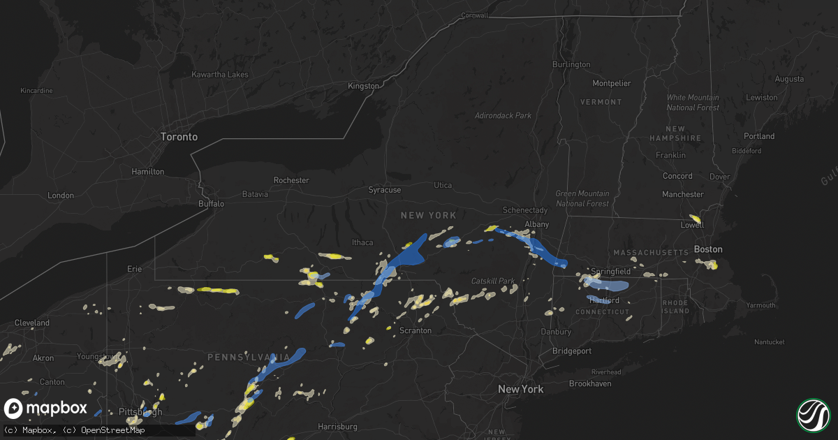
Hail Map in New York on July 7, 2021
Get this storm
July 7 map
$229
one time, instant access
Download today. No call, no setup
Keep the $229
Bought the map and want the full workflow? Apply the entire $229 to a subscription within 7 days. None of it is wasted.
Every map, not just this one
This buys you this map. Subscription and you get every map we run, in the markets you choose from a few cities to whole states to nationwide. Plus real-time alerts the moment a storm fires.
Contact data
Name, contact info, occupancy, even credit band for addresses in the footprint. You go from where it hit to who to call.
Become the source they trust
Unlimited branding weather history reports on demand. You already have the documented answer ready for the property owner, and you are the one who showed up with it.
Property data and RoofTrace estimates
Pull up any address you have got, its value and the exact code rules for that jurisdiction, straight from One Click Code. Then RoofTrace estimates the squares, pitch, and roof value, priced the way you price.
Storm reports in New York
New York
| Date | Description |
|---|---|
| 07/07/20216:20 PM CDT | Trees down on power lines along edith ave |
| 07/07/20216:13 PM CDT | Tree down on power lines |
| 07/07/20216:13 PM CDT | Tree down on power lines along county rd 38 |
| 07/07/20216:10 PM CDT | Tree down across road on cr16... No wires involved. |
| 07/07/20216:09 PM CDT | Trees down on power lines along north nesmith ave |
| 07/07/20216:09 PM CDT | Trees down on power lines along north nesmith ave. |
| 07/07/20216:03 PM CDT | Trees down on power lines. |
| 07/07/20216:03 PM CDT | Trees down on power lines near diffley rd |
| 07/07/20215:51 PM CDT | Several trees were downed blocking lawson lake road |
| 07/07/20215:17 PM CDT | Tree down on oregon road blocking 2/3rds of the roadway. Time estimated. |
| 07/07/20214:50 PM CDT | A local report indicates 1.00 inch wind near ONEONTA |
| 07/07/20214:45 PM CDT | Trees and utility lines down on north kortwright church road. |
| 07/07/20214:40 PM CDT | Tree down on power service on resident with smoke filling house. |
| 07/07/20214:38 PM CDT | Downed tree blocking county highway 3a. |
| 07/07/20214:35 PM CDT | Trees and utility lines down on buck road. |
| 07/07/20214:33 PM CDT | Tree leaning on wires and on fire on four corners road between jackson and elm |
| 07/07/20214:33 PM CDT | Tree and wires down on county route 7 between westfall road and tims road |
| 07/07/20214:30 PM CDT | Several trees down in town of davenport with one tree into a residence. |
| 07/07/20212:29 PM CDT | Trees down on wires and one tree down on an unoccupied car on south waldron lane |
| 07/07/20212:17 PM CDT | Route 9j closed between day road and route 26a near stockport due to downed trees |
| 07/07/20212:12 PM CDT | Trees down on wires at route 9j and county route 46 |
| 07/07/20212:11 PM CDT | Several reports of trees and wires down in the stuyvesant area |
| 07/07/20212:04 PM CDT | Several reports of trees down between new baltimore and coxsackie |
| 07/07/20211:50 PM CDT | Several trees were downed in coeymans hollow. Route 143 was closed between blodgett hill road and gedney hill road due to a downed tree and wires. |
| 07/07/20211:10 PM CDT | Live tree around 6 inches in diameter snapped. Also a few large 3-4 inch diameter branches downed in a yard. |
| 07/07/20211:04 PM CDT | A few trees and several branches down of various sizes along hard scrabble road |
| 07/07/20211:04 PM CDT | Tree snapped and large branches down with siding damage near route 30 at carriage house lane and pleasant valley road |
| 07/07/202112:45 PM CDT | Several reports of trees downed in richmondville |
| 07/07/20216:20 AM CDT | At 1119 PM EDT, severe thunderstorms were located along a line extending from near Exeter Center to Davenport to near Andes, moving northeast at 45 mph. HAZARD...60 mph wind gusts and penny size hail. SOURCE...Radar indicated. IMPACT...Expect damage to roofs, siding, and trees. Locations impacted include... Johnstown, Ilion, Herkimer, Little Falls, Cobleskill, Canajoharie, Fonda, Jefferson, Mohawk, Frankfort, Fort Plain, Dolgeville, St. Johnsville, Ephratah, Middleburgh, Gilboa, Summit, Schoharie, Richmondville and West Winfield. |
| 07/07/20216:02 AM CDT | At 1102 PM EDT, severe thunderstorms were located along a line extending from 8 miles southwest of Margaretville to Kerhonkson, moving northeast at 45 mph. HAZARD...60 mph wind gusts and penny size hail. SOURCE...Radar indicated. IMPACT...Expect damage to roofs, siding, and trees. Locations impacted include... Kingston, Ellenville, Saugerties, Hunter, Hurley, Woodstock, Clermont, Red Hook, Windham, Prattsville, Napanoch, Woodland Valley Campground, Phoenicia, Mount Tremper, Olivebridge, Kerhonkson, West Hurley, Saugerties South, North-South Lake Campground and West Shokan. |
| 07/07/20215:41 AM CDT | At 1041 PM EDT, severe thunderstorms were located along a line extending from near Plymouth to near Harvard, moving east at 45 mph. HAZARD...60 mph wind gusts and quarter size hail. SOURCE... These storms have produced widespread downed trees and wires with widespread power outages. IMPACT...Hail damage to vehicles is expected. Expect wind damage to roofs, siding, and trees. Locations impacted include... Oneonta, Norwich, Sidney, Walton, Delhi, Davenport, Guilford, Roxbury, Worcester and Middlefield. |
| 07/07/20215:06 AM CDT | At 1004 PM EDT, severe thunderstorms were located along a line extending from near Berkshire to near Royal, moving northeast at 45 mph. HAZARD...70 mph wind gusts and quarter size hail. SOURCE...Radar indicated. IMPACT...70 mph gusts with a danergrous microburst near Binghamton airport moving northeast toward Chenango Forks and Whitney Point. Elsewhere with 60 mph gusts, Hail damage to vehicles is expected. Expect considerable tree damage. Wind damage is also likely to mobile homes,roofs, and outbuildings. Locations impacted include... Binghamton, Vestal, Johnson City, Endicott, Norwich, Kirkwood, Conklin, Maine, Sidney and Jackson. |
| 07/07/20214:24 AM CDT | At 923 PM EDT, severe thunderstorms were located along a line extending from Van Etten to Sweet Valley, moving northeast at 35 mph. HAZARD...60 mph wind gusts and quarter size hail. SOURCE... Several reports of downed trees and wires. IMPACT...Hail damage to vehicles is expected. Expect wind damage to roofs, siding, and trees. Locations impacted include... Binghamton, Falls, Vestal, Muhlenberg, Johnson City, Endicott, Barton, Vernon, Maine and Rush. |
| 07/07/20213:38 AM CDT | At 838 PM EDT, severe thunderstorms were located along a line extending from Meads Creek to 7 miles northwest of Mansfield, moving east at 40 mph. HAZARD...70 mph wind gusts and quarter size hail. SOURCE... Trees and Wires have been downed due to winds. IMPACT...Hail damage to vehicles is expected. Expect considerable tree damage. Wind damage is also likely to mobile homes, roofs, and outbuildings. Locations impacted include... Chemung, Elmira, Corning, Southport, Barton, Big Flats, Horseheads, Sayre, Waverly and Elmira Heights. |
| 07/07/20213:25 AM CDT | At 825 PM EDT, a severe thunderstorm was located over Sherman, moving east at 20 mph. HAZARD...60 mph wind gusts and quarter size hail. SOURCE...Radar indicated. IMPACT...Minor hail damage to vehicles is possible. Expect wind damage to trees and power lines. This severe thunderstorm will be near... Sherman around 830 PM EDT. |
| 07/07/20213:23 AM CDT | At 823 PM EDT, a severe thunderstorm was located over Gaylordsville, or near Sherman, moving east at 25 mph. HAZARD...60 mph wind gusts and quarter size hail. SOURCE...Radar indicated. IMPACT...Hail damage to vehicles is expected. Expect wind damage to roofs, siding, and trees. Locations impacted include... New Milford, Thomaston, Oakville, New Preston, Terryville, Woodbury Center, Wingdale, Gaylordsville, Watertown, Plymouth, Woodbury, Bethlehem, Washington, Morris, Roxbury, Bridgewater, Bantam, Hotchkissville, Pequabuck and Baker Corner. |
| 07/07/20213:04 AM CDT | At 804 PM EDT, a severe thunderstorm was located near Elkland, moving east at 20 mph. HAZARD...60 mph wind gusts and quarter size hail. SOURCE...Radar indicated. IMPACT...Hail damage to vehicles is expected. Expect wind damage to roofs, siding, and trees. Locations impacted include... Elkland, Millerton, Tioga, Knoxville, Osceola and Tioga Junction. |
| 07/07/20212:55 AM CDT | At 755 AM EDT, a severe thunderstorm was located over Scipio Center, or 11 miles south of Auburn, moving east at 35 mph. HAZARD...60 mph wind gusts and penny size hail. SOURCE...Radar indicated. IMPACT...Expect damage to roofs, siding, and trees. Locations impacted include... Owasco, Fleming, Locke, Genoa, Ledyard, Moravia, Union Springs, Niles, Scott and Sempronius. |
| 07/07/20212:12 AM CDT | At 711 PM EDT, a severe thunderstorm was located near Genesee, moving east at 20 mph. HAZARD...60 mph wind gusts and penny size hail. SOURCE...Radar indicated. IMPACT...Expect damage to roofs, siding, and trees. Locations impacted include... Whitesville, Andover, Stannards and Paynesville. |
| 07/07/20212:08 AM CDT | At 708 PM EDT, a severe thunderstorm was located near Hartwick, or 10 miles north of Oneonta, moving northeast at 20 mph. HAZARD...60 mph wind gusts and quarter size hail. SOURCE...Radar indicated. IMPACT...Hail damage to vehicles is expected. Expect wind damage to roofs, siding, and trees. Locations impacted include... Worcester, Middlefield, Hartwick, Cooperstown, Westville, New Lisbon, Westford, Cherry Valley, Milford and Bowerstown. |
| 07/07/20212:03 AM CDT | At 703 PM EDT, a severe thunderstorm was located 7 miles east of Belfast, or 12 miles north of Wellsville, moving east at 25 mph. HAZARD...60 mph wind gusts and quarter size hail. SOURCE...Radar indicated. IMPACT...Minor damage to vehicles is possible. Expect wind damage to roofs, siding, and trees. Locations impacted include... Alfred, Belfast, Friendship, Belmont, Angelica, Canaseraga, Almond, West Almond and Birdsall. This includes Interstate 86 between exits 29 and 33. |
| 07/07/20211:47 AM CDT | At 646 PM EDT, severe thunderstorms were located along a line extending from Wattsburg to near Sheffield, moving northeast at 45 mph. HAZARD...60 mph wind gusts and penny size hail. SOURCE...Radar indicated. IMPACT...Expect damage to roofs, siding, and trees. Locations impacted include... Jamestown, Olean, Fredonia, Salamanca, Allegany State Park, Westfield, Lakewood, Falconer, Allegany, Panama, Busti, and Mayville. This includes the following highways... Interstate 90 between exits 61 and 60. Interstate 86 between exits 4 and 26. |
| 07/07/20211:43 AM CDT | At 641 PM EDT, a severe thunderstorm was located near Port Allegany, moving east at 30 mph. HAZARD...70 mph wind gusts and quarter size hail. SOURCE...Law enforcement reported hail and numerous downed trees in the path of this storm. IMPACT...Hail damage to vehicles is expected. Expect considerable tree damage. Wind damage is also likely to mobile homes, roofs, and outbuildings. Locations impacted include... Coudersport, Port Allegany, Roulette, Shinglehouse, Genesee, Denton Hill State Park, Harrison Valley, Ulysses, Sweden Valley, Oswayo and Ski Denton Ski Area. |
| 07/07/20211:35 AM CDT | At 635 PM EDT, a severe thunderstorm was located over Summit, or 11 miles southwest of Cobleskill, moving east at 25 mph. HAZARD...60 mph wind gusts and nickel size hail. SOURCE...Radar indicated. IMPACT...Expect damage to roofs, siding, and trees. Locations impacted include... Berne, Middleburgh, Summit, Schoharie, Breakabeen, Knox, Baird Corners, West Berne, Huntersland, Old Stone Fort, Lutheranville, West Fulton, Vintonton, Arabia, Eminence, Housons Corners, Beards Hollow, Zucks Corners, Watsonville and West Township. |
| 07/07/20211:31 AM CDT | At 631 PM EDT, a severe thunderstorm was located over Monterey, or 10 miles north of Corning, moving east at 25 mph. HAZARD...60 mph wind gusts and quarter size hail. SOURCE...Radar indicated. IMPACT...Hail damage to vehicles is expected. Expect wind damage to roofs, siding, and trees. Locations impacted include... Horseheads, Catharine, Hornby, Millport, Meads Creek, Horseheads North, Monterey, Fisherville, Mark Twain State Park and Beaver Dams. |
| 07/07/20211:29 AM CDT | At 629 PM EDT, severe thunderstorms were located along a line extending from Grand Valley to 10 miles southwest of Sheffield, moving northeast at 35 mph. HAZARD...60 mph wind gusts and quarter size hail. SOURCE...Radar indicated. IMPACT...Hail damage to vehicles is expected. Expect wind damage to roofs, siding, and trees. Locations impacted include... Warren, Sheffield, Youngsville, Russell, Spring Creek, Scandia, Lottsville, Grand Valley, Warren South, Garland, Kinzua Dam, Chapman State Park, Ludlow, Tidioute, Sugar Grove, Starbrick and Clarendon. |
| 07/07/20211:25 AM CDT | At 625 PM EDT, a severe thunderstorm was located near Middleburgh, or 12 miles southeast of Cobleskill, moving east at 25 mph. HAZARD...60 mph wind gusts and nickel size hail. SOURCE...Radar indicated. IMPACT...Expect damage to roofs, siding, and trees. Locations impacted include... Westerlo, Berne, Voorheesville, Altamont, Middleburgh, Livingstonville, Feura Bush, Breakabeen, New Scotland, Knox, Rensselaerville, Clarksville, East Berne, Meadowdale, Shoefelt Corners, South Albany, West Berne, Huntersland, Selkirk Yards and Spawn Hollow. |
| 07/07/20211:10 AM CDT | At 610 PM EDT, a severe thunderstorm was located near Gilbertsville, or near Norwich, moving northeast at 20 mph. HAZARD...60 mph wind gusts and quarter size hail. SOURCE...Radar indicated. IMPACT...Hail damage to vehicles is expected. Expect wind damage to roofs, siding, and trees. Locations impacted include... Oneonta, New Lisbon, Morris, Gilbertsville, Laurens, West End, Emmons, Mt Vision, Gilbert Lake State Park and Lathams Corners. |
| 07/07/20211:06 AM CDT | At 606 PM EDT, a severe thunderstorm was located over Feura Bush, or near Delmar, moving east at 30 mph. HAZARD...60 mph wind gusts and penny size hail. SOURCE...Radar indicated. IMPACT...Expect damage to roofs, siding, and trees. Locations impacted include... Albany, East Greenbush, Rensselaer, Nassau, Delmar, Ravena, Stephentown, Berlin, Castleton-On-Hudson, West Sand Lake, Averill Park, Feura Bush, Selkirk, Sand Lake, Coeymans, Poestenkill, Clarksville, East Nassau, Coeymans Hollow and Brookview. |
| 07/07/20211:00 AM CDT | At 600 PM EDT, a severe thunderstorm was located over Cayuta, or near Odessa, moving east at 20 mph. HAZARD...60 mph wind gusts and quarter size hail. SOURCE...Radar indicated. IMPACT...Hail damage to vehicles is expected. Expect wind damage to roofs, siding, and trees. Locations impacted include... Spencer, Cayuta, Van Etten, Willseyville, South Danby, West Danby, North Spencer, West Candor, Swartwood and Alpine. |
| 07/07/202112:55 AM CDT | At 554 PM EDT, a severe thunderstorm was located near Cyclone, moving east at 20 mph. HAZARD...60 mph wind gusts and quarter size hail. SOURCE...Radar indicated. IMPACT...Hail damage to vehicles is expected. Expect wind damage to roofs, siding, and trees. Locations impacted include... Bradford, Port Allegany, Smethport, Rew, Coryville, Cyclone, Eldred, Lewis Run, University Of Pittsburgh - Bradford and Bradford Airport. |
| 07/07/202112:47 AM CDT | At 546 PM EDT, a severe thunderstorm was located over Smithville Flats, or 12 miles east of Marathon, moving east at 15 mph. HAZARD...60 mph wind gusts and nickel size hail. SOURCE...Radar indicated. IMPACT...Expect damage to roofs, siding, and trees. Locations impacted include... Guilford, Oxford, Brisben, Smithville Flats, South Oxford, Smithville Center and Tyner. |
| 07/07/202112:42 AM CDT | At 541 PM EDT, a severe thunderstorm was located near Davenport, or 14 miles northeast of Delhi, moving east at 30 mph. HAZARD...60 mph wind gusts and quarter size hail. SOURCE...Radar indicated. IMPACT...Hail damage to vehicles is expected. Expect wind damage to roofs, siding, and trees. Locations impacted include... Jefferson, Gilboa, North Blenheim, Breakabeen, Conesville, Baird Corners, Manorkill, Broome Center, West Fulton, Five Corners, Arabia, West Conesville, Eminence, Housons Corners, West Jefferson, South Gilboa, South Jefferson, Watsonville, Vorman Corners and Ruth. |
| 07/07/202112:40 AM CDT | At 540 PM EDT, a severe thunderstorm was located near Davenport, or 14 miles northeast of Delhi, moving east at 25 mph. HAZARD...60 mph wind gusts and nickel size hail. SOURCE...Radar indicated. IMPACT...Expect damage to roofs, siding, and trees. Locations impacted include... Kortright, Stamford and Butts Corner. |
| 07/07/202112:13 AM CDT | At 513 PM EDT, a severe thunderstorm was located near Otego, or 9 miles southwest of Oneonta, moving east at 25 mph. HAZARD...60 mph wind gusts and quarter size hail. SOURCE...Radar indicated. IMPACT...Hail damage to vehicles is expected. Expect wind damage to roofs, siding, and trees. Locations impacted include... Oneonta, Delhi, Davenport, Maryland, Kortright, Meredith, Unadilla, Otego, Franklin and West End. |
| 07/07/202112:07 AM CDT | At 506 PM EDT, a severe thunderstorm was located over Scandia, moving east at 15 mph. HAZARD...60 mph wind gusts and quarter size hail. SOURCE...Radar indicated. IMPACT...Hail damage to vehicles is expected. Expect wind damage to roofs, siding, and trees. Locations impacted include... Bradford, Scandia, Marshburg, Kinzua Dam, Lewis Run, University Of Pittsburgh - Bradford and Bradford Airport. |
| 07/06/202111:20 PM CDT | A tree was downed on route 9g between hyde park and rhinebeck |
| 07/06/202111:12 PM CDT | A tree was downed onto a house on creek locks road |
| 07/06/202111:02 PM CDT | Tree down on wires on atwood road near vly atwood road |
| 07/06/202111:02 PM CDT | Tree down on wires on pine bush road near stilba lane |
| 07/06/202111:00 PM CDT | Trees down on grovers corners road in the town of carlisle. |
| 07/06/202110:58 PM CDT | Tree down on wires on route 209 |
| 07/06/202110:54 PM CDT | A tree was downed in the roadway on foordmoore road near routes 44 and 55 |
| 07/06/202110:40 PM CDT | Tree down on wires. |
| 07/06/202110:29 PM CDT | At 328 PM EDT, a severe thunderstorm was located near Lorenz Park, or near Hudson, moving southeast at 25 mph. HAZARD...60 mph wind gusts and penny size hail. SOURCE...Radar indicated. IMPACT...Expect damage to roofs, siding, and trees. Locations impacted include... Hudson, Chatham, Claverack, Copake, New Baltimore, Coxsackie, Valatie, Athens, Austerlitz, Philmont, Kinderhook, Lorenz Park, Claverack-Red Mills, Ghent, Stockport, Stuyvesant, Hillsdale, Taghkanic, Churchtown and Rossman. |
| 07/06/202110:25 PM CDT | Trees and wires down on airport road. Via scanner. |
| 07/06/202110:15 PM CDT | Tree down on stanton corners road. Via dispatch scanner. Radar estimated time. |
| 07/06/202110:10 PM CDT | Tree down across stanton corners road... Via scanner. Other trees down in area. Radar estimated time. |
| 07/06/202110:05 PM CDT | Tree down on wires. |
| 07/06/202110:00 PM CDT | Trees down. Also... Water and rocks over fuller hill road. Via dispatch scanner. Radar estimated time. |
| 07/06/20219:58 PM CDT | At 257 PM EDT, a severe thunderstorm was located over New Baltimore, or 9 miles west of Nassau, moving east at 40 mph. HAZARD...70 mph wind gusts and penny size hail. SOURCE...Radar indicated. IMPACT...Expect considerable tree damage. Damage is likely to mobile homes, roofs, and outbuildings. Locations impacted include... Chatham, Nassau, New Baltimore, Ravena, Coxsackie, New Lebanon, Valatie, Austerlitz, Castleton-On-Hudson, Kinderhook, Selkirk, Coeymans, Ghent, Stuyvesant, Canaan, East Nassau, Brookview, Van Hoesen Station, Jacks Corners and Beckers Corners. |
| 07/06/20219:40 PM CDT | Trees and wires down blocking road. |
| 07/06/20219:36 PM CDT | Report from mping: 1-inch tree limbs broken; shingles blown off. |
| 07/06/20219:25 PM CDT | At 225 PM EDT, a severe thunderstorm was located near Berne, or 17 miles west of Delmar, moving east at 35 mph. HAZARD...60 mph wind gusts and penny size hail. SOURCE...Radar indicated. IMPACT...Expect damage to roofs, siding, and trees. Locations impacted include... Delmar, New Baltimore, Westerlo, Ravena, Coxsackie, Berne, Feura Bush, Preston Hollow, Selkirk, Preston-Potter Hollow, Coeymans, Rensselaerville, Clarksville, Coeymans Hollow, East Berne, Shoefelt Corners, West Berne, Spawn Hollow, Dormansville and Beckers Corners. |
| 07/06/20219:25 PM CDT | Upper lisle route 26 - trees blocking half of road in 2 spots... Another completely blocking merrill creek road. |
| 07/06/20219:15 PM CDT | Tree down all the way across patch road near high school. Reported to nws via social media. Radar estimated time. |
| 07/06/20219:11 PM CDT | Report from mping: quarter |
| 07/06/20219:10 PM CDT | 2 greenhouses blown over. Report to nws via social media. Radar estimated time. |
| 07/06/20219:00 PM CDT | Tree down on carl road. |
| 07/06/20218:55 PM CDT | Tree down on car south of vestal center near state border. Pic sent to nws on social media. Radar estimated time. |
| 07/06/20218:55 PM CDT | Tree down on vehicle. Other trees and wires down. |
| 07/06/20218:55 PM CDT | Large tree down in backyard. Reported to nws by homeowner. Radar estimated time. |
| 07/06/20218:55 PM CDT | Roof partially peeled off and awning damage at the 100 block of odell ave in the little italy section of endicott. Time estimated by radar. |
| 07/06/20218:53 PM CDT | Tree down blocking echo road. |
| 07/06/20218:50 PM CDT | Tree down on vehicle with vehicle on fire. Trees and lines down. Report via social media. Radar estimated time. |
| 07/06/20218:50 PM CDT | Garage heavily damaged. Vehicle crushed. Pic reported to broadcast media... Sent to nws. Radar estimated time. |
| 07/06/20218:48 PM CDT | Commercial lighted sign knocked down/destroyed at visions credit union on ny-434. |
| 07/06/20218:48 PM CDT | Multiple trees and wires down... Blocking roads on south side of apalachin. Reported to nws via social media. Radar estimated time. |
| 07/06/20218:48 PM CDT | Update to previous tstm wnd gst report from 1 ssw tioga terrace. Measured with kestrel anemometer. 1393 feet elevation on lillie hill road. Trunk snaps halfway up trees |
| 07/06/20217:58 PM CDT | Trees on route 20. |
| 07/06/20217:50 PM CDT | Multiple trees and wires down. Reported to nws via social media. Radar estimated time. |
| 07/06/20217:45 PM CDT | Wires down on trees. |
| 07/06/20217:35 PM CDT | Multiple trees down county route 5. |
| 07/06/20217:09 PM CDT | Tree down across martins corners rd |
All States Impacted by Hail Map on July 7, 2021
Cities Impacted by Hail Map on July 7, 2021
- Albion, MI
- Springport, MI
- Sarver, PA
- Edgerton, OH
- Bryan, OH
- Warren, PA
- Oxford, MI
- Leonard, MI
- New Milford, CT
- Gaylordsville, CT
- South Kent, CT
- Mansfield, OH
- Crestline, OH
- Bucyrus, OH
- Galion, OH
- Shelby, OH
- Dayton, PA
- Punxsutawney, PA
- Northpoint, PA
- Smicksburg, PA
- Sterling Heights, MI
- Warren, MI
- Harrison Township, MI
- Clinton Township, MI
- Fraser, MI
- Saint Clair Shores, MI
- Harsens Island, MI
- Roseville, MI
- Pulaski, PA
- Hillsville, PA
- Lowellville, OH
- New Wilmington, PA
- New Castle, PA
- New Middletown, OH
- Youngstown, OH
- Campbell, OH
- Edinburg, PA
- Struthers, OH
- Volant, PA
- Bessemer, PA
- Jefferson, PA
- Waynesburg, PA
- Carmichaels, PA
- Middleburgh, NY
- Lutherville Timonium, MD
- Pikesville, MD
- Towson, MD
- Baltimore, MD
- New Albany, PA
- Wyalusing, PA
- Mount Vision, NY
- New Berlin, NY
- Norwich, NY
- South New Berlin, NY
- Mount Upton, NY
- Morris, NY
- Guilford, NY
- New Lisbon, NY
- Enid, OK
- Drummond, OK
- Lahoma, OK
- Snow Shoe, PA
- Clarence, PA
- Newburg, PA
- Shippensburg, PA
- Lurgan, PA
- Orrstown, PA
- Lewistown, MT
- Tyrone, PA
- Hollidaysburg, PA
- Duncansville, PA
- East Freedom, PA
- Portage, PA
- Queen, PA
- Claysburg, PA
- Newry, PA
- Roaring Spring, PA
- Jersey, AR
- Terry, MT
- Covington, PA
- Mansfield, PA
- Mainesburg, PA
- South Weymouth, MA
- Holbrook, MA
- Braintree, MA
- Randolph, MA
- Abington, MA
- Equinunk, PA
- Long Eddy, NY
- Hankins, NY
- Hillsgrove, PA
- Williamsport, PA
- Russell, PA
- Lewis Run, PA
- Bradford, PA
- Addison, NY
- Columbia Cross Roads, PA
- Troy, PA
- Upton, WY
- Moorcroft, WY
- Sturbridge, MA
- Charlton, MA
- Southbridge, MA
- Dudley, MA
- Belmont, NY
- Almond, NY
- Angelica, NY
- Altoona, PA
- Mifflintown, PA
- Pittsburg, MO
- Smethport, PA
- Rew, PA
- Gifford, PA
- South Gibson, PA
- Susquehanna, PA
- Union Dale, PA
- Thompson, PA
- Jackson, PA
- Torrington, WY
- Canton, PA
- Berlin, PA
- Central City, PA
- Vestal, NY
- Owego, NY
- Endicott, NY
- Nichols, NY
- Johnson City, NY
- Rome, PA
- Little Meadows, PA
- Newark Valley, NY
- Apalachin, NY
- Ashland, OH
- Natrona Heights, PA
- Tarentum, PA
- Garrett, PA
- New Florence, PA
- Boswell, PA
- Ligonier, PA
- New Milford, PA
- Pond Creek, OK
- Olivet, MI
- Charlotte, MI
- Warren, MA
- Fairmont, WV
- New Kensington, PA
- Pittsburgh, PA
- Kingsley, PA
- Winchester, VA
- Benton, PA
- Osceola, PA
- New Paris, PA
- Schellsburg, PA
- New Cumberland, WV
- Forksville, PA
- Rensselaerville, NY
- Binghamton, NY
- Tariffville, CT
- Simsbury, CT
- Grass Range, MT
- Holly, MI
- Guys Mills, PA
- New Preston Marble Dale, CT
- Washington Depot, CT
- Nicholson, PA
- Saint Johns, MI
- Elsie, MI
- Ashley, MI
- Bannister, MI
- Perrinton, MI
- Franklin, NY
- Oneonta, NY
- Jefferson, OH
- Rock Creek, OH
- West Mifflin, PA
- Braddock, PA
- East Pittsburgh, PA
- Homestead, PA
- Turtle Creek, PA
- Fairhope, PA
- Nevada, MO
- Walker, MO
- Fredonia, KS
- Forsyth, MT
- Lisbon, OH
- Salineville, OH
- McAlisterville, PA
- Burnham, PA
- Oakland Mills, PA
- Yeagertown, PA
- Richfield, PA
- McClure, PA
- Lewistown, PA
- Reedsville, PA
- Butler, PA
- Saint Clair, MI
- Sullivan, OH
- Homerville, OH
- Spencer, OH
- Barkhamsted, CT
- Cayuta, NY
- Horseheads, NY
- Alum Bank, PA
- Buffalo, KS
- North Branch, NY
- Cochecton, NY
- Swan Lake, NY
- Livingston Manor, NY
- Jeffersonville, NY
- Hortonville, NY
- White Sulphur Springs, NY
- Callicoon, NY
- Damascus, PA
- Youngsville, NY
- Pleasant Hall, PA
- Roxbury, PA
- Pleasant Mount, PA
- Lakewood, PA
- Johnstown, PA
- Burgettstown, PA
- Sugarloaf, PA
- Neversink, NY
- Woodbourne, NY
- Tioga, PA
- Lawrenceville, PA
- Harrison, NE
- Edon, OH
- Montpelier, OH
- Creekside, PA
- Rural Valley, PA
- Shelocta, PA
- Northville, MI
- Lenoxville, PA
- Waymart, PA
- Hop Bottom, PA
- Herrick Center, PA
- Harford, PA
- Forest City, PA
- Roundup, MT
- Winnett, MT
- Leipsic, OH
- Sandisfield, MA
- Moore, MT
- Painted Post, NY
- Cameron Mills, NY
- Woodhull, NY
- Lindley, NY
- Apple Creek, OH
- Fredericksburg, OH
- Beaver Dams, NY
- Millport, NY
- Scio, NY
- Alfred Station, NY
- Andover, NY
- Jay Em, WY
- Red Hook, NY
- Fairmont, OK
- Covington, OK
- East Hartland, CT
- Casco, MI
- Hammond, MT
- Alzada, MT
- Boyes, MT
- Carson City, MI
- Webster, MA
- Bethel Park, PA
- Venetia, PA
- Canonsburg, PA
- Lawrence, PA
- Bridgeville, PA
- Leechburg, PA
- Milanville, PA
- Tyler Hill, PA
- Kenoza Lake, NY
- Dracut, MA
- Methuen, MA
- Pelham, NH
- Andover, MA
- Davenport, NY
- East Meredith, NY
- Beech Creek, PA
- Hannacroix, NY
- Novi, MI
- Tunkhannock, PA
- Westby, MT
- Raymond, MT
- Plentywood, MT
- Miller, SD
- Wessington, SD
- Ulster, PA
- Towanda, PA
- Wysox, PA
- Middle Bass, OH
- Put In Bay, OH
- West Pittsburg, PA
- Wampum, PA
- Campbell, NY
- Savona, NY
- Pine Valley, NY
- Hundred, WV
- New Freeport, PA
- Burton, WV
- Wassaic, NY
- Brookfield, MA
- Granville, MA
- Southwick, MA
- North Granby, CT
- Avon, MA
- Weymouth, MA
- Rockland, MA
- Deshler, OH
- Nemacolin, PA
- Greensboro, PA
- Granville Summit, PA
- Hilger, MT
- Monroeton, PA
- State College, PA
- Uniontown, PA
- Winsted, CT
- Oliveburg, PA
- Winfield, KS
- Grand Valley, PA
- Titusville, PA
- Glenshaw, PA
- Goshen, IN
- Topeka, IN
- Shipshewana, IN
- Millersburg, IN
- Kewanna, IN
- Rochester, IN
- Algonac, MI
- Fostoria, OH
- Kansas, OH
- New Philadelphia, OH
- Warrensburg, IL
- Maroa, IL
- Litchfield, OH
- Grafton, OH
- Hollsopple, PA
- Cheyenne, OK
- Philipsburg, PA
- Farmington, MI
- Huntingdon, PA
- Ellenville, NY
- Napanoch, NY
- Grahamsville, NY
- Lower Brule, SD
- Kingston, NY
- Cottekill, NY
- Hurley, NY
- Petersburg, PA
- Walled Lake, MI
- South Lyon, MI
- Wixom, MI
- West Bloomfield, MI
- Summit, NY
- Richmondville, NY
- Fultonham, NY
- Warnerville, NY
- Schoharie, NY
- Weston, OH
- Osceola, MO
- Marysville, OH
- Raymond, OH
- Claryville, NY
- Coeymans Hollow, NY
- Westerlo, NY
- Greenville, NY
- McDonald, PA
- Great Barrington, MA
- Sheffield, MA
- Nelson, PA
- Knoxville, PA
- Jasper, NY
- Middlebury Center, PA
- Elkland, PA
- Fenelton, PA
- Chicora, PA
- Saugerties, NY
- North Grosvenordale, CT
- Monroeville, IN
- Cecil, OH
- Sherwood, OH
- Defiance, OH
- Lisle, NY
- Berkshire, NY
- Galeton, PA
- Hudson, NY
- Cocolamus, PA
- Lucas, OH
- Bellville, OH
- Youngsville, PA
- Sugar Grove, PA
- Factoryville, PA
- Woodburn, IN
- Harlan, IN
- Antwerp, OH
- New Haven, IN
- Orrville, OH
- Dalton, OH
- Coventry, CT
- Columbia, CT
- Montoursville, PA
- Powell, OH
- Ostrander, OH
- Delaware, OH
- Dorset, OH
- Andover, OH
- Howell, MI
- Douglas, MA
- Zortman, MT
- Roy, MT
- Berne, NY
- Marion, OH
- Evans, WA
- Otego, NY
- Unadilla, NY
- Rileyville, VA
- Luray, VA
- Caledonia, OH
- Centerville, PA
- Tidioute, PA
- Coxsackie, NY
- Athens, NY
- Catskill, NY
- McComb, OH
- Custar, OH
- Hoytville, OH
- Holliston, MA
- Staunton, VA
- Bellwood, PA
- Valley City, OH
- Brunswick, OH
- Townville, PA
- Davis, WV
- Linesville, PA
- Uxbridge, MA
- Normantown, WV
- Glenville, WV
- Cedarville, WV
- Knox, IN
- Bloomville, NY
- West Mansfield, OH
- Hyde Park, NY
- Poughkeepsie, NY
- Highland, NY
- Rome, OH
- Prompton, PA
- Honesdale, PA
- Hammon, OK
- The Colony, TX
- Feura Bush, NY
- Climax, NY
- West Coxsackie, NY
- Alcove, NY
- Clarksville, NY
- Selkirk, NY
- Delmar, NY
- East Berne, NY
- Ravena, NY
- Bellefonte, PA
- Allison Park, PA
- Verona, PA
- Medford, OK
- Kremlin, OK
- Nash, OK
- Kitzmiller, MD
- Pinckney, MI
- Olivebridge, NY
- Frenchville, PA
- East Granby, CT
- West Granby, CT
- Granby, CT
- West Hartland, CT
- Riverton, CT
- Colebrook, CT
- West Suffield, CT
- Warren Center, PA
- Brackney, PA
- Pawling, NY
- Wingdale, NY
- Sherman, CT
- Stone Ridge, NY
- Springville, PA
- Montrose, PA
- Cairnbrook, PA
- East China, MI
- Brimfield, MA
- Corry, PA
- Columbus, PA
- Osterburg, PA
- Mount Storm, WV
- Elk Garden, WV
- Dansville, MI
- Broadway, VA
- Stockbridge, MI
- Gregory, MI
- Mark Center, OH
- Hicksville, OH
- Lanse, PA
- Millerstown, PA
- Stuyvesant, NY
- Stuyvesant Falls, NY
- Ghent, NY
- Kinderhook, NY
- Earlton, NY
- Morgantown, WV
- Pursglove, WV
- Cedar Vale, KS
- Lumberton, NC
- Cuddy, PA
- Cecil, PA
- Cabot, PA
- Saxonburg, PA
- Parksville, NY
- Loch Sheldrake, NY
- Liberty, NY
- Ferndale, NY
- Hurleyville, NY
- Timberville, VA
- Bronson, KS
- Lake Lynn, PA
- Point Marion, PA
- Maidsville, WV
- Linn, WV
- Alum Bridge, WV
- Muncy Valley, PA
- Carbondale, PA
- Mount Blanchard, OH
- Carey, OH
- Vanlue, OH
- Wharton, OH
- Fairview, OK
- Franklin, MI
- Milford, MI
- Hamburg, MI
- Brighton, MI
- Southfield, MI
- Whitmore Lake, MI
- Bloomfield Hills, MI
- Commerce Township, MI
- New Hudson, MI
- Livonia, MI
- Davenport, IA
- Walcott, IA
- Kittanning, PA
- Candor, NY
- Lagrange, OH
- Wellington, OH
- Medina, OH
- Imler, PA
- Maurertown, VA
- Nevada, OH
- Harrisville, PA
- West Oneonta, NY
- Celina, OH
- Mendon, OH
- Cross Junction, VA
- Longton, KS
- Elk City, KS
- Jermyn, PA
- Olyphant, PA
- Warsaw, MO
- Lincoln, MO
- Slippery Rock, PA
- Tipton, PA
- Port Matilda, PA
- Bridgeport, OH
- New Bethlehem, PA
- Whitney Point, NY
- Smithville Flats, NY
- Greene, NY
- Hancock, NY
- Stone Creek, OH
- Fresno, OH
- Dexter, KS
- Millville, PA
- Ringgold, PA
- Worthville, PA
- Mayport, PA
- Sprankle Mills, PA
- Roscoe, NY
- Fremont Center, NY
- Staatsburg, NY
- Dallas, PA
- Mercer, PA
- Fredonia, PA
- Sugar Run, PA
- Millersburg, OH
- Mount Morris, PA
- Ortonville, MI
- Kerhonkson, NY
- Accord, NY
- West Shokan, NY
- Irvine, PA
- Pittsfield, PA
- Chesterton, IN
- Westville, IN
- Shiloh, OH
- Noxen, PA
- Mineral Point, PA
- Parkhill, PA
- Independence, OH
- Cleveland, OH
- Stoughton, MA
- East Weymouth, MA
- Quincy, MA
- Dedham, MA
- Milton, MA
- Westwood, MA
- Norwood, MA
- Dover, MA
- Canton, MA
- Eldridge, IA
- Windsor, CT
- Windsor Locks, CT
- Rosedale, WV
- Gassaway, WV
- Culver, IN
- Hamilton, PA
- Milroy, PA
- Bowling Green, OH
- Lawrence, MA
- Laurens, NY
- New Salem, PA
- Ware, MA
- West Brookfield, MA
- West Warren, MA
- Colchester, CT
- Lebanon, CT
- South Park, PA
- Carnegie, PA
- Eighty Four, PA
- Presto, PA
- Morgan, PA
- Finleyville, PA
- Oakdale, PA
- Oldtown, MD
- Flintstone, MD
- Hysham, MT
- Friedens, PA
- Spruce Creek, PA
- Warriors Mark, PA
- Howard, PA
- Mill Hall, PA
- Sandy Ridge, PA
- Blanchard, PA
- Osceola Mills, PA
- Lock Haven, PA
- Karthaus, PA
- Julian, PA
- Morris, PA
- Gaines, PA
- Wellsboro, PA
- Loyalhanna, PA
- Blairsville, PA
- Robinson, PA
- Bolivar, PA
- Bradenville, PA
- Latrobe, PA
- Derry, PA
- Afton, NY
- Shunk, PA
- Bainbridge, NY
- Oxford, NY
- Port Crane, NY
- Castle Creek, NY
- Chenango Forks, NY
- Harpursville, NY
- Glen Aubrey, NY
- Le Raysville, PA
- Maine, NY
- Muncy, PA
- Canton, CT
- Wethersfield, CT
- East Hartford, CT
- Glastonbury, CT
- Burlington, CT
- West Hartford, CT
- Hartford, CT
- Avon, CT
- Farmington, CT
- Suffield, CT
- Tolland, CT
- South Windsor, CT
- Bloomfield, CT
- Ellington, CT
- Broad Brook, CT
- West Simsbury, CT
- Enfield, CT
- East Windsor, CT
- Stafford Springs, CT
- Somers, CT
- Belgrade, MT
- Bozeman, MT
- Garryowen, MT
- Billings, MT
- Saint Xavier, MT
- Laurel, MT
- Broadview, MT
- Big Timber, MT
- Acton, MT
- Busby, MT
- Hardin, MT
- Ryegate, MT
- Rapelje, MT
- Ballantine, MT
- Huntley, MT
- Molt, MT
- Crow Agency, MT
- Pompeys Pillar, MT
- Lodge Grass, MT
- Lavina, MT
- Rosebud, MT
- Powderville, MT
- Ismay, MT
- Volborg, MT
- Biddle, MT
- Ekalaka, MT
- Philmont, NY
- Hillsdale, NY
- Housatonic, MA
- New Baltimore, NY
- South Egremont, MA
- Chatham, NY
- Valatie, NY
- West Stockbridge, MA
- Coeymans, NY
- Schodack Landing, NY
- South Kortright, NY
- Stamford, NY
- Harpersfield, NY
- Hobart, NY
- Jefferson, NY
- North Blenheim, NY
- West Fulton, NY
- Pine City, NY
- Corning, NY
- Pine Ridge, SD
- Hingham, MA
- Williamsburg, PA
- Apollo, PA
- Vandergrift, PA
- McDonough, NY
- Beach City, OH
- Wilmot, OH
- Dundee, OH
- Cygnet, OH
- North Baltimore, OH
- Rudolph, OH
- Toronto, OH
- Steubenville, OH
- Van Tassell, WY
- Lusk, WY
- Merriman, NE
- Battle Creek, MI


