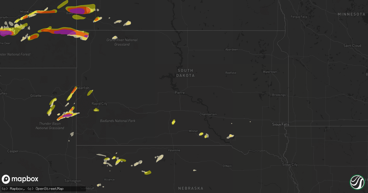
Hail Map in South Dakota on July 4, 2022
Get this storm
July 4 map
$229
one time, instant access
Download today. No call, no setup
Keep the $229
Bought the map and want the full workflow? Apply the entire $229 to a subscription within 7 days. None of it is wasted.
Every map, not just this one
This buys you this map. Subscription and you get every map we run, in the markets you choose from a few cities to whole states to nationwide. Plus real-time alerts the moment a storm fires.
Contact data
Name, contact info, occupancy, even credit band for addresses in the footprint. You go from where it hit to who to call.
Become the source they trust
Unlimited branding weather history reports on demand. You already have the documented answer ready for the property owner, and you are the one who showed up with it.
Property data and RoofTrace estimates
Pull up any address you have got, its value and the exact code rules for that jurisdiction, straight from One Click Code. Then RoofTrace estimates the squares, pitch, and roof value, priced the way you price.
Storm reports in South Dakota
South Dakota
| Date | Description |
|---|---|
| 07/04/20225:58 PM CDT | A local report indicates 1.00 inch wind near 1 WNW STURGIS |
| 07/04/20224:39 PM CDT | A local report indicates 1.00 inch wind near 4 NE HAYWARD |
| 07/04/20227:54 AM CDT | At 1254 AM CDT, severe thunderstorms were located along a line extending from near Groton to near Camrose Colony, moving east at 35 mph. HAZARD...60 mph wind gusts. SOURCE...Radar indicated. IMPACT...Expect damage to roofs, siding, and trees. Severe thunderstorms will be near... Andover around 105 AM CDT.Other locations in the path of these severe thunderstorms includeRaymond, Bristol, Butler, Clark and Webster. |
| 07/04/20227:42 AM CDT | At 1242 AM CDT, a severe thunderstorm was located near Joe Creek Rec Area, or 9 miles west of Lower Brule, moving east at 35 mph. HAZARD...60 mph wind gusts. SOURCE...Radar indicated. IMPACT...Expect damage to roofs, siding, and trees. This severe thunderstorm will be near... Lower Brule and Medicine Butte around 100 AM CDT.Other locations in the path of this severe thunderstorm includeCounselor Creek Boat Access Area, Tailrace Rec Area, Lake Sharpe,Fort Thompson, Lees Corner, Crow Creek Housing, Shelby and EtbauerHill. |
| 07/04/20227:39 AM CDT | At 1238 AM CDT/1138 PM MDT/, severe thunderstorms were located along a line extending from 5 miles northwest of Taylor to 4 miles southwest of Mott to 7 miles southwest of Hettinger, moving east at 40 mph. HAZARD...70 mph wind gusts. SOURCE...Radar indicated. IMPACT...Expect considerable tree damage. Damage is likely to mobile homes, roofs, and outbuildings. Severe thunderstorms will be near... Mott around 1145 PM MDT. Richardton around 1150 PM MDT.Other locations in the path of these severe thunderstorms includeHaynes, Hebron, New Leipzig, Elgin, North Lemmon and Carson. |
| 07/04/20227:30 AM CDT | At 1230 AM CDT, severe thunderstorms were located along a line extending from 8 miles northwest of Vivian to 8 miles southwest of 5 Mile Corner to 8 miles north of Mosher to near Fairgrounds Housing, moving east at 45 mph. HAZARD...60 mph wind gusts and penny size hail. SOURCE...Radar indicated. IMPACT...Expect damage to roofs, siding, and trees. Locations impacted include... Winner, Mission, White River, Rosebud, Okreek, Ideal, Wood, Carter, Mosher, Witten, Hamill, Soldier Creek, Ideal South Housing, Butte Creek, Swift Bear, Ring Thunder, Fairgrounds Housing, Antelope, Horse Creek and Hidden Timber. |
| 07/04/20227:26 AM CDT | At 1226 AM CDT, a severe thunderstorm was located near Stratford, or 10 miles southeast of Aberdeen, moving east at 15 mph. HAZARD...60 mph wind gusts. SOURCE...Radar indicated. IMPACT...Expect damage to roofs, siding, and trees. Locations impacted include... Verdon and Ferney. |
| 07/04/20227:15 AM CDT | At 1214 AM CDT, a severe thunderstorm was located 12 miles east of Westover, or 18 miles southeast of Murdo, moving east at 40 mph. HAZARD...60 mph wind gusts. SOURCE...Radar indicated. IMPACT...Expect damage to roofs, siding, and trees. This severe thunderstorm will remain over mainly rural areas of southeastern Jones and southwestern Lyman Counties. |
| 07/04/20227:08 AM CDT | At 1208 AM CDT, a severe thunderstorm was located near Mellette, or 17 miles north of Redfield, moving east at 35 mph. HAZARD...60 mph wind gusts. SOURCE...Radar indicated. IMPACT...Expect damage to roofs, siding, and trees. This severe thunderstorm will be near... Brentford around 1215 AM CDT.Other locations in the path of this severe thunderstorm include Condeand Turton. |
| 07/04/20227:04 AM CDT | At 1203 AM CDT, a severe thunderstorm was located over Warner, or 8 miles south of Aberdeen, moving east at 35 mph. HAZARD...70 mph wind gusts. SOURCE...Radar indicated. IMPACT...Expect considerable tree damage. Damage is likely to mobile homes, roofs, and outbuildings. This severe thunderstorm will be near... Stratford around 1215 AM CDT.Other locations in the path of this severe thunderstorm includeVerdon. |
| 07/04/20226:55 AM CDT | A local report indicates 1.25 inch wind near 2 E LADNER |
| 07/04/20226:55 AM CDT | A local report indicates 1.75 inch wind near 4 ESE LADNER |
| 07/04/20223:13 AM CDT | At 813 PM MDT, a severe thunderstorm was located 4 miles north of Moskee, or 9 miles southeast of Sundance, moving northeast at 30 mph. HAZARD...60 mph wind gusts and quarter size hail. SOURCE...Radar indicated. IMPACT...Hail damage to vehicles is expected. Expect wind damage to roofs, siding, and trees. Locations impacted include... Spearfish, Beulah, Moskee, Iron Creek Lake, Crow Peak, Cement Ridge Lookout and northern Spearfish Canyon.This includes... Interstate 90 in South Dakota between Mile Markers 1 and 13. Interstate 90 in Wyoming between Mile Markers 201 and 207. |
| 07/04/20222:43 AM CDT | At 743 PM MDT, a severe thunderstorm was located 3 miles south of Newcastle, moving east at 20 mph. HAZARD...60 mph wind gusts and half dollar size hail. SOURCE...Radar indicated. IMPACT...Hail damage to vehicles is expected. Expect wind damage to roofs, siding, and trees. Locations impacted include... Newcastle, Moon and Jewel Cave National Monument. |
| 07/04/20221:52 AM CDT | At 651 PM MDT, a severe thunderstorm was located 7 miles west of Newcastle, moving northeast at 30 mph. HAZARD...Ping pong ball size hail and 60 mph wind gusts. SOURCE...Radar indicated. IMPACT...People and animals outdoors will be injured. Expect hail damage to roofs, siding, windows, and vehicles. Expect wind damage to roofs, siding, and trees. Locations impacted include... Newcastle, Flag Mountain, Moon, Four Corners, Buckhorn, Deerfield, Deerfield Reservoir, O'Neil Pass, Medicine Mountain, Redbank Spring Campground, Crooks Tower, Mallo Camp and Black Fox Campground. |
| 07/04/202212:56 AM CDT | At 556 PM MDT, a severe thunderstorm was located near Redbird, or 23 miles west of Edgemont, moving northeast at 20 mph. HAZARD...60 mph wind gusts and nickel size hail. SOURCE...Radar indicated. IMPACT...Expect damage to roofs, siding, and trees. Locations impacted include... Mule Creek Junction and Redbird. |
| 07/04/202212:30 AM CDT | At 530 PM MDT, a severe thunderstorm was located 3 miles northwest of Newcastle, moving northeast at 30 mph. HAZARD...Ping pong ball size hail and 60 mph wind gusts. SOURCE...Radar indicated. IMPACT...People and animals outdoors will be injured. Expect hail damage to roofs, siding, windows, and vehicles. Expect wind damage to roofs, siding, and trees. Locations impacted include... Newcastle, Flag Mountain, Moon, Four Corners, Deerfield, Buckhorn, Deerfield Reservoir, Crooks Tower, Mallo Camp, O'Neil Pass, Black Fox Campground and Redbank Spring Campground. |
| 07/03/202211:50 PM CDT | At 450 PM MDT, a severe thunderstorm was located near Sturgis, moving northeast at 25 mph. HAZARD...Half dollar size hail. SOURCE...Radar indicated. IMPACT...Damage to vehicles is expected. Locations impacted include... Sturgis, Vale, Apple Springs, Bear Butte State Park and Fort Meade.This includes Interstate 90 in South Dakota between Mile Markers 28and 37. |
| 07/03/202210:19 PM CDT | At 319 PM MDT, a severe thunderstorm was located 3 miles north of Hayward, or 11 miles south of Rapid City, moving southeast at 25 mph. HAZARD...60 mph wind gusts and half dollar size hail. SOURCE...Radar indicated. IMPACT...Hail damage to vehicles is expected. Expect wind damage to roofs, siding, and trees. This severe thunderstorm will be near... Hart Ranch around 325 PM MDT. Hermosa around 335 PM MDT. Folsom around 410 PM MDT. |
| 07/03/20229:03 PM CDT | At 203 AM CDT, severe thunderstorms were located along a line extending from near Etbauer Hill to 6 miles west of Kimball to 7 miles east of Iona, moving east at 40 mph. HAZARD...60 mph wind gusts and penny size hail. SOURCE...Radar indicated. IMPACT...Expect damage to roofs, siding, and trees. Severe thunderstorms will be near... Kimball around 215 AM CDT. Grass Ranch Colony around 220 AM CDT.Other locations in the path of these severe thunderstorms includeWhite Lake, Wessington Springs and Plankinton. |
| 07/03/20228:36 PM CDT | At 136 AM CDT, severe thunderstorms were located along a line extending from near Stephan to near Dude Ranch to near Hamill, moving east at 30 mph. HAZARD...60 mph wind gusts and penny size hail. SOURCE...Radar indicated. IMPACT...Expect damage to roofs, siding, and trees. Severe thunderstorms will be near... Lake Francis Case around 140 AM CDT. Chamberlain around 150 AM CDT.Other locations in the path of these severe thunderstorms includeKimball. |
| 07/03/20228:32 PM CDT | At 132 AM CDT, severe thunderstorms were located along a line extending from 6 miles north of Stephan to near Oacoma to 10 miles south of Hamill, moving east at 30 mph. HAZARD...60 mph wind gusts. SOURCE...Radar indicated. IMPACT...Expect damage to roofs, siding, and trees. Severe thunderstorms will be near... Oacoma and Dude Ranch around 135 AM CDT. Crow Creek Housing around 145 AM CDT. Shelby and Iona around 150 AM CDT.Other locations in the path of these severe thunderstorms includeSunshine Bible Academy, Pleasant Valley Country Church and RosehillDam. |
All States Impacted by Hail Map on July 4, 2022
Cities Impacted by Hail Map on July 4, 2022
- Denton, MT
- Lewistown, MT
- Cascade, MT
- Haviland, OH
- Gregory, SD
- Dallas, SD
- Armour, SD
- Geddes, SD
- Lake Andes, SD
- Hemingford, NE
- Hettinger, ND
- Hay Springs, NE
- Bradshaw, NE
- Benedict, NE
- Polk, NE
- Volborg, MT
- Leslie, GA
- Strawberry Point, IA
- Garber, IA
- Elkader, IA
- Volga, IA
- Guttenberg, IA
- Arlington, IA
- Edgewood, IA
- Colesburg, IA
- Wadena, IA
- Elkport, IA
- Fayette, IA
- Elgin, IA
- York, NE
- Hardin, MT
- Bighorn, MT
- Colstrip, MT
- Forsyth, MT
- Glendale Heights, IL
- Hanover Park, IL
- Carol Stream, IL
- West Chicago, IL
- Bloomingdale, IL
- Bartlett, IL
- Two Dot, MT
- Alliance, NE
- Roberts, IL
- Cottageville, SC
- Ridgeville, SC
- Lavina, MT
- Billings, MT
- Pecatonica, IL
- Winnebago, IL
- Newcastle, WY
- Ryegate, MT
- Shawmut, MT
- Harlowton, MT
- Osage, WY
- Laotto, IN
- Churubusco, IN
- Camp Crook, SD
- Baker, MT
- Ekalaka, MT
- Buffalo, SD
- Fredericksburg, IA
- Sumner, IA
- Ionia, IA
- Upton, WY
- Moorcroft, WY
- Custer, SD
- Valentine, NE
- Miles City, MT
- Livingston, MT
- Molt, MT
- Huntley, MT
- Ballantine, MT
- Rapelje, MT
- Wilsall, MT
- Worden, MT
- Pompeys Pillar, MT
- Big Timber, MT
- Acton, MT
- Shepherd, MT
- Melville, MT
- Broadview, MT
- Springfield, GA
- Gridley, IL
- Whitewater, WI
- Palmyra, WI
- Bowman, ND
- Scranton, ND
- Rosebud, MT
- Avilla, IN
- Albion, IN
- Columbia City, IN
- Fort Benton, MT
- Hanahan, SC
- Sundance, WY
- Beulah, WY
- Alexandria, SD
- Merriman, NE
- Whitney, NE
- Chadron, NE
- Bayard, NE
- Burke, SD
- Andersonville, GA
- Americus, GA
- Lodgepole, SD
- Whitman, NE
- Jonesboro, GA
- Keystone, SD
- Rapid City, SD
- Drummond, MT
- Clinton, MT
- Lance Creek, WY
- Paxton, IL
- Cissna Park, IL
- Loda, IL
- Rankin, IL
- Buckley, IL
- Hilger, MT
- Helena, MT
- Amidon, ND
- Jefferson, WI
- Stoughton, WI
- Fort Atkinson, WI
- Mcfarland, WI
- Cambridge, WI
- Cottage Grove, WI
- Deerfield, WI
- Otter, MT
- Fort Meade, SD
- Fort Valley, GA
- Perry, GA
- Marshallville, GA
- Maynard, IA
- Westgate, IA
- Prairie City, SD
- Moore, MT
- Putnam, IL
- Tiskilwa, IL
- Buda, IL
- Bradford, IL
- Hennepin, IL
- Princeton, IL
- Mark, IL
- Wyanet, IL
- Granville, IL
- Cody, NE
- Grass Range, MT
- Winnett, MT
- Forest Grove, MT
- Stickney, SD
- Aiken, SC
- Ridge Spring, SC
- Meridian, MS
- Rushville, NE
- Roundup, MT
- Mosby, MT
- Judith Gap, MT
- Sand Springs, MT
- Ingomar, MT
- Brusett, MT
- Cohagen, MT
- Reeder, ND
- Mott, ND
- Culver, IN
- Tonica, IL
- Peru, IL
- Lostant, IL
- Flaxville, MT
- Brockton, MT
- Barrington, IL
- Lake Zurich, IL
- Saint George, SC
- North Charleston, SC
- Ladson, SC
- Nashua, IA
- New Hampton, IA
- Ravenel, SC
- Adams Run, SC
- Randalia, IA
- Aurora, IA
- Oelwein, IA
- Lamont, IA
- Long Pine, NE
- Ainsworth, NE
- Poplar, MT
- Reserve, MT
- Scobey, MT
- Benson, IL
- Dodgeville, WI
- Mineral Point, WI
- Quitman, MS
- Rhame, ND
- Waterloo, IN
- Ismay, MT
- Auburn, IN
- Summerville, SC
- Angora, NE
- Penfield, IL
- Gifford, IL
- Rantoul, IL
- Albany, WI
- Monticello, WI
- Round O, SC
- Argyle, WI
- South Wayne, WI
- Monroe, WI
- Browntown, WI
- Darlington, WI
- Gratiot, WI
- Woodford, WI
- Chicago, IL
- Orangeville, IL
- Dakota, IL
- Durand, IL
- Wood, SD
- White River, SD
- Caledonia, IL
- Roscoe, IL
- Sycamore, IL
- Machesney Park, IL
- Burlington, IL
- Cherry Valley, IL
- Rockford, IL
- Garden Prairie, IL
- Poplar Grove, IL
- Marengo, IL
- Capron, IL
- Genoa, IL
- Harvard, IL
- Huntley, IL
- Union, IL
- Loves Park, IL
- Belvidere, IL
- Hampshire, IL
- Arlington Heights, IL
- Schaumburg, IL
- Des Plaines, IL
- Palatine, IL
- Streamwood, IL
- Elk Grove Village, IL
- Hoffman Estates, IL
- Mount Prospect, IL
- Rolling Meadows, IL
- Lancaster, WI
- Forrest, IL
- Fairbury, IL
- Graymont, IL
- Minonk, IL
- Pontiac, IL
- Flanagan, IL
- Rockton, IL
- Streator, IL
- Marsland, NE
- Burlington, WI
- Kansasville, WI
- East Troy, WI
- Rochester, WI
- Eagle, WI
- Waterford, WI
- Orfordville, WI
- Clinton, WI
- Beloit, WI
- Janesville, WI
- South Beloit, IL
- Park Ridge, IL
- Cary, IL
- Niles, IL
- Dundee, IL
- Algonquin, IL
- Fox River Grove, IL
- Crystal Lake, IL
- Carpentersville, IL
- Lake In The Hills, IL
- Colfax, IL
- Chenoa, IL
- Chatsworth, IL
- Wenona, IL
- Toluca, IL
- El Paso, IL
- Dana, IL
- Roanoke, IL
- Washburn, IL
- Ancona, IL
- Sibley, IL
- Cropsey, IL
- Long Point, IL
- Rutland, IL
- Belmont, WI
- Rock City, IL
- New Glarus, WI
- Belleville, WI
- Davis, IL
- Roselle, IL
- Hollandale, WI
- Lincolnwood, IL
- Wayne, IL
- Freeport, IL
- Saint Charles, IL
- Glenview, IL
- Winslow, IL
- Bensenville, IL
- Kirkland, IL
- Juda, WI
- Woodstock, IL
- Shirland, IL
- Morton Grove, IL
- Livingston, WI
- Afton, WI
- Kingston, IL
- Itasca, IL
- Wood Dale, IL
- Brodhead, WI
- Maple Park, IL
- Ridott, IL
- Medinah, IL
- Sharon, WI
- Fennimore, WI
- Evansville, WI
- Stitzer, WI
- Skokie, IL
- Elgin, IL
- Brooklyn, WI
- Harwood Heights, IL
- Rewey, WI
- South Elgin, IL
- Prospect Heights, IL
- Gilberts, IL
- Blanchardville, WI
- McConnell, IL
- Platteville, WI
- Holcomb, IL
- Stillman Valley, IL
- German Valley, IL
- Leaf River, IL
- Byron, IL
- Esmond, IL
- Lindenwood, IL
- Davis Junction, IL
- Monroe Center, IL
- Rochelle, IL
- Froid, MT
- Homestead, MT
- Medicine Lake, MT
- Springerville, AZ
- Deadwood, SD
- Sturgis, SD
- Mule Creek, NM
- Arcola, IN
- Fort Wayne, IN
- Larwill, IN
- Pierceton, IN
- Craigville, IN
- Ossian, IN
- Decatur, IN
- Malta, IL
- Chana, IL
- Wonder Lake, IL
- McCook, NE
- Marmarth, ND
- Plevna, MT
- Sentinel Butte, ND
- Spearfish, SD
- Reed Point, MT
- Broadus, MT
- Gordon, NE


