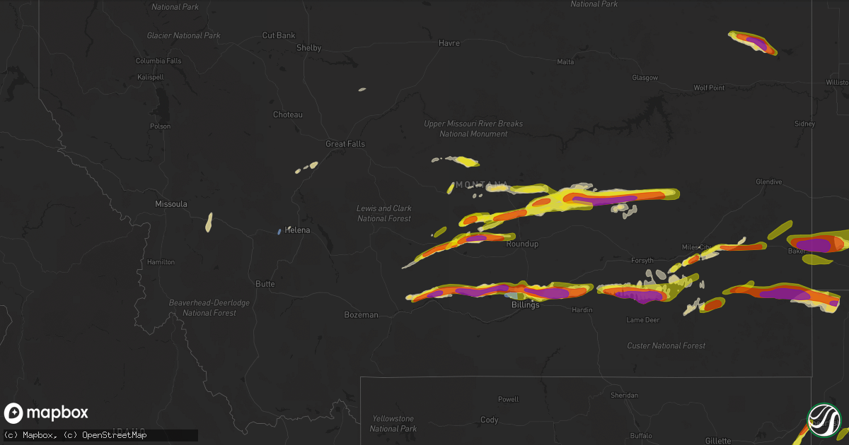
Hail Map in Montana on July 4, 2022
Get this storm
July 4 map
$229
one time, instant access
Download today. No call, no setup
Keep the $229
Bought the map and want the full workflow? Apply the entire $229 to a subscription within 7 days. None of it is wasted.
Every map, not just this one
This buys you this map. Subscription and you get every map we run, in the markets you choose from a few cities to whole states to nationwide. Plus real-time alerts the moment a storm fires.
Contact data
Name, contact info, occupancy, even credit band for addresses in the footprint. You go from where it hit to who to call.
Become the source they trust
Unlimited branding weather history reports on demand. You already have the documented answer ready for the property owner, and you are the one who showed up with it.
Property data and RoofTrace estimates
Pull up any address you have got, its value and the exact code rules for that jurisdiction, straight from One Click Code. Then RoofTrace estimates the squares, pitch, and roof value, priced the way you price.
Storm reports in Montana
Montana
| Date | Description |
|---|---|
| 07/04/20224:21 PM CDT | 64 mph wind gust at the dot sensor on macdonald pass. Heavy rain also falling. |
| 07/04/20226:15 AM CDT | A local report indicates 1.00 inch wind near 11 SE WEBSTER |
| 07/04/20225:50 AM CDT | Picture sent by spotter via social media. |
| 07/04/20225:49 AM CDT | A local report indicates 1.25 inch wind near 1 W COLSTRIP |
| 07/04/20225:45 AM CDT | Spotter report of rain and golf ball sized hail. |
| 07/04/20225:41 AM CDT | At 1041 PM MDT, a severe thunderstorm was located near Hillside, or 33 miles southeast of Jordan, moving east at 60 mph. HAZARD...Half dollar size hail. SOURCE...Radar indicated. IMPACT...Damage to vehicles is expected. Locations impacted include... Cohagen, Hillside, Brockway, Mccloud, Crow Rock and Watkins. |
| 07/04/20224:47 AM CDT | At 946 PM MDT, a severe thunderstorm was located 14 miles south of Edwards, or 31 miles southwest of Jordan, moving east at 50 mph. HAZARD...Half dollar size hail. SOURCE...Radar indicated. IMPACT...Damage to vehicles is expected. Locations impacted include... Sand Springs, Cohagen, Edwards and Hillside. |
| 07/04/20224:29 AM CDT | At 929 PM MDT, a severe thunderstorm was located 16 miles south of Sand Springs, or 40 miles east of Winnett, moving east at 30 mph. HAZARD...Ping pong ball size hail and 60 mph wind gusts. SOURCE...Radar indicated. IMPACT...People and animals outdoors will be injured. Expect hail damage to roofs, siding, windows, and vehicles. Expect wind damage to roofs, siding, and trees. This severe thunderstorm will remain over mainly rural areas of north central Rosebud County. |
| 07/04/20224:25 AM CDT | A local report indicates 87 MPH wind near 13 NE BAKER |
| 07/04/20223:56 AM CDT | A local report indicates 1.00 inch wind near 1 W BALLANTINE |
| 07/04/20223:45 AM CDT | A local report indicates 2.00 inch wind near 2 S HUNTLEY |
| 07/04/20223:44 AM CDT | A local report indicates 1.00 inch wind near 1 NNE SHEPHERD |
| 07/04/20223:38 AM CDT | A local report indicates 2.00 inch wind near HUNTLEY |
| 07/04/20223:35 AM CDT | A local report indicates 2.75 inch wind near BILLINGS |
| 07/04/20223:35 AM CDT | A local report indicates 1.25 inch wind near 2 W SHEPHERD |
| 07/04/20223:34 AM CDT | A local report indicates 1.50 inch wind near SHEPHERD |
| 07/04/20223:33 AM CDT | A local report indicates 2.00 inch wind near 4 SSW SHEPHERD |
| 07/04/20223:30 AM CDT | A local report indicates 1.50 inch wind near SHEPHERD |
| 07/04/20223:30 AM CDT | A local report indicates 1.50 inch wind near 4 NNE BILLINGS |
| 07/04/20223:26 AM CDT | A local report indicates 2.00 inch wind near 9 N BILLINGS |
| 07/04/20223:25 AM CDT | A local report indicates 2.00 inch wind near 7 NE BILLINGS |
| 07/04/20223:24 AM CDT | A local report indicates 1.00 inch wind near 4 N BILLINGS |
| 07/04/20223:23 AM CDT | A local report indicates 2.00 inch wind near SHEPHERD |
| 07/04/20223:18 AM CDT | At 818 PM MDT, a severe thunderstorm was located near Winnett, moving east at 30 mph. HAZARD...Quarter size hail. SOURCE...Radar indicated. IMPACT...Damage to vehicles is expected. Locations impacted include... Winnett, Mosby, Petrolia Lake and Cat Creek. |
| 07/04/20222:43 AM CDT | At 742 PM MDT, a severe thunderstorm was located 27 miles northeast of Deadmans Basin Reservoir, or 27 miles southeast of Lewistown, moving east at 25 mph. HAZARD...60 mph wind gusts and half dollar size hail. SOURCE...Radar indicated. IMPACT...Hail damage to vehicles is expected. Expect wind damage to roofs, siding, and trees. This severe thunderstorm will remain over mainly rural areas of northwestern Musselshell and north central Golden Valley Counties. |
| 07/04/20222:39 AM CDT | At 738 PM MDT, severe thunderstorms were located along a line extending from 24 miles southeast of Lewistown to 7 miles northwest of Grass Range, moving east at 20 mph. HAZARD...60 mph wind gusts and quarter size hail. SOURCE...Radar indicated. IMPACT...Hail damage to vehicles is expected. Expect wind damage to roofs, siding, and trees. Localized flash flooding will be possible. Locations impacted include... Grass Range and Forestgrove. |
| 07/04/20222:18 AM CDT | Time estimated from radar. |
| 07/04/20222:13 AM CDT | At 711 PM MDT, a severe thunderstorm was located over Harlowton, moving northeast at 30 mph. Additional severe storms were located over far northeast Wheatland county, moving northeast at 25 mph. HAZARD...Ping pong ball size hail and 60 mph wind gusts. SOURCE...Radar indicated. IMPACT...People and animals outdoors will be injured. Expect hail damage to roofs, siding, windows, and vehicles. Expect wind damage to roofs, siding, and trees. This severe thunderstorm will remain over mainly rural areas of eastern Wheatland and north central Golden Valley Counties.This replaces the previous warning for this area. |
| 07/04/20221:52 AM CDT | At 652 PM MDT, a severe thunderstorm was located near Harlowton, moving northeast at 30 mph. HAZARD...60 mph wind gusts and half dollar size hail. SOURCE...Radar indicated. IMPACT...Hail damage to vehicles is expected. Expect wind damage to roofs, siding, and trees. This severe thunderstorm will be near... Harlowton around 705 PM MDT. |
| 07/04/20221:40 AM CDT | At 639 PM MDT, a severe thunderstorm was located 16 miles south of Winifred, or 17 miles north of Lewistown, moving east at 30 mph. HAZARD...60 mph wind gusts and quarter size hail. SOURCE...Radar indicated. IMPACT...Hail damage to vehicles is expected. Expect wind damage to roofs, siding, and trees. Locations impacted include... Roy, Fergus, Hilger and Christina. |
| 07/04/20221:24 AM CDT | At 624 PM MDT, a severe thunderstorm was located near Moore, or 9 miles west of Lewistown, moving north at 15 mph. HAZARD...60 mph wind gusts and penny size hail. SOURCE...Radar indicated. IMPACT...Expect damage to roofs, siding, and trees. Locations impacted include... Lewistown, Moore, Danvers and Glengarry. |
| 07/04/20221:18 AM CDT | Time estimated from radar. |
| 07/04/202212:49 AM CDT | At 549 PM MDT, a severe thunderstorm was located 12 miles northeast of Bredette, or 21 miles southeast of Scobey, moving east at 30 mph. HAZARD...Golf ball size hail and 60 mph wind gusts. SOURCE...Radar indicated. IMPACT...People and animals outdoors will be injured. Expect hail damage to roofs, siding, windows, and vehicles. Expect wind damage to roofs, siding, and trees. Locations impacted include... Plentywood, Medicine Lake, Bainville, Froid, Flaxville, Archer, Redstone, Reserve, Dagmar, Homestead, Navajo, Mccabe, Antelope and Coalridge. |
| 07/04/202212:09 AM CDT | At 509 PM MDT, a severe thunderstorm was located near Cascade, moving east at 25 mph. HAZARD...60 mph wind gusts and quarter size hail. SOURCE...Radar indicated. IMPACT...Hail damage to vehicles is expected. Expect wind damage to roofs, siding, and trees. Localized flash flooding possible. Locations impacted include... Cascade, First Peoples Buffalo Jump State Park and Ulm. |
| 07/03/202211:29 PM CDT | At 429 PM MDT, a severe thunderstorm was located 12 miles west of Drummond, moving north at 20 mph. HAZARD...Ping pong ball size hail and 60 mph wind gusts. SOURCE...Radar indicated. IMPACT...People and animals outdoors will be injured. Expect hail damage to roofs, siding, windows, and vehicles. Expect wind damage to roofs, siding, and trees. Locations impacted include... Garnet, Nimrod and Bearmouth. |
| 07/03/202211:06 PM CDT | At 406 PM MDT, a severe thunderstorm was located 12 miles west of Drummond, moving north at 30 mph. HAZARD...Ping pong ball size hail and 60 mph wind gusts. SOURCE...Radar indicated. IMPACT...People and animals outdoors will be injured. Expect hail damage to roofs, siding, windows, and vehicles. Expect wind damage to roofs, siding, and trees. Locations impacted include... Drummond, Garnet, Hall and Bearmouth. |
| 07/03/202210:48 PM CDT | At 347 PM MDT, a severe thunderstorm was located 14 miles northwest of Helena, moving north at 50 mph. HAZARD...60 mph wind gusts and quarter size hail. SOURCE...Radar indicated. IMPACT...Hail damage to vehicles is expected. Expect wind damage to roofs, siding, and trees. Localized flash flooding possible. Locations impacted include... Wolf Creek, Marysville, Canyon Creek and Austin. |
| 07/03/20229:45 PM CDT | Quarter size hail blown into drifts along trees with wind damage. |
| 07/03/20229:45 PM CDT | Nickel size hail blown into drifts along trees with wind damage. |
| 07/03/20229:20 PM CDT | Hail the size of large peas covering the ground... Heavy rainfall observed. |
| 07/03/20228:15 PM CDT | Hail reported after storm. |
| 07/03/20227:55 PM CDT | Mostly dime size hail with golf ball size hail reported via social media. |
| 07/03/20227:00 PM CDT | Report relayed from facebook. |
All States Impacted by Hail Map on July 4, 2022
Cities Impacted by Hail Map on July 4, 2022
- Denton, MT
- Lewistown, MT
- Cascade, MT
- Haviland, OH
- Gregory, SD
- Dallas, SD
- Armour, SD
- Geddes, SD
- Lake Andes, SD
- Hemingford, NE
- Hettinger, ND
- Hay Springs, NE
- Bradshaw, NE
- Benedict, NE
- Polk, NE
- Volborg, MT
- Leslie, GA
- Strawberry Point, IA
- Garber, IA
- Elkader, IA
- Volga, IA
- Guttenberg, IA
- Arlington, IA
- Edgewood, IA
- Colesburg, IA
- Wadena, IA
- Elkport, IA
- Fayette, IA
- Elgin, IA
- York, NE
- Hardin, MT
- Bighorn, MT
- Colstrip, MT
- Forsyth, MT
- Glendale Heights, IL
- Hanover Park, IL
- Carol Stream, IL
- West Chicago, IL
- Bloomingdale, IL
- Bartlett, IL
- Two Dot, MT
- Alliance, NE
- Roberts, IL
- Cottageville, SC
- Ridgeville, SC
- Lavina, MT
- Billings, MT
- Pecatonica, IL
- Winnebago, IL
- Newcastle, WY
- Ryegate, MT
- Shawmut, MT
- Harlowton, MT
- Osage, WY
- Laotto, IN
- Churubusco, IN
- Camp Crook, SD
- Baker, MT
- Ekalaka, MT
- Buffalo, SD
- Fredericksburg, IA
- Sumner, IA
- Ionia, IA
- Upton, WY
- Moorcroft, WY
- Custer, SD
- Valentine, NE
- Miles City, MT
- Livingston, MT
- Molt, MT
- Huntley, MT
- Ballantine, MT
- Rapelje, MT
- Wilsall, MT
- Worden, MT
- Pompeys Pillar, MT
- Big Timber, MT
- Acton, MT
- Shepherd, MT
- Melville, MT
- Broadview, MT
- Springfield, GA
- Gridley, IL
- Whitewater, WI
- Palmyra, WI
- Bowman, ND
- Scranton, ND
- Rosebud, MT
- Avilla, IN
- Albion, IN
- Columbia City, IN
- Fort Benton, MT
- Hanahan, SC
- Sundance, WY
- Beulah, WY
- Alexandria, SD
- Merriman, NE
- Whitney, NE
- Chadron, NE
- Bayard, NE
- Burke, SD
- Andersonville, GA
- Americus, GA
- Lodgepole, SD
- Whitman, NE
- Jonesboro, GA
- Keystone, SD
- Rapid City, SD
- Drummond, MT
- Clinton, MT
- Lance Creek, WY
- Paxton, IL
- Cissna Park, IL
- Loda, IL
- Rankin, IL
- Buckley, IL
- Hilger, MT
- Helena, MT
- Amidon, ND
- Jefferson, WI
- Stoughton, WI
- Fort Atkinson, WI
- Mcfarland, WI
- Cambridge, WI
- Cottage Grove, WI
- Deerfield, WI
- Otter, MT
- Fort Meade, SD
- Fort Valley, GA
- Perry, GA
- Marshallville, GA
- Maynard, IA
- Westgate, IA
- Prairie City, SD
- Moore, MT
- Putnam, IL
- Tiskilwa, IL
- Buda, IL
- Bradford, IL
- Hennepin, IL
- Princeton, IL
- Mark, IL
- Wyanet, IL
- Granville, IL
- Cody, NE
- Grass Range, MT
- Winnett, MT
- Forest Grove, MT
- Stickney, SD
- Aiken, SC
- Ridge Spring, SC
- Meridian, MS
- Rushville, NE
- Roundup, MT
- Mosby, MT
- Judith Gap, MT
- Sand Springs, MT
- Ingomar, MT
- Brusett, MT
- Cohagen, MT
- Reeder, ND
- Mott, ND
- Culver, IN
- Tonica, IL
- Peru, IL
- Lostant, IL
- Flaxville, MT
- Brockton, MT
- Barrington, IL
- Lake Zurich, IL
- Saint George, SC
- North Charleston, SC
- Ladson, SC
- Nashua, IA
- New Hampton, IA
- Ravenel, SC
- Adams Run, SC
- Randalia, IA
- Aurora, IA
- Oelwein, IA
- Lamont, IA
- Long Pine, NE
- Ainsworth, NE
- Poplar, MT
- Reserve, MT
- Scobey, MT
- Benson, IL
- Dodgeville, WI
- Mineral Point, WI
- Quitman, MS
- Rhame, ND
- Waterloo, IN
- Ismay, MT
- Auburn, IN
- Summerville, SC
- Angora, NE
- Penfield, IL
- Gifford, IL
- Rantoul, IL
- Albany, WI
- Monticello, WI
- Round O, SC
- Argyle, WI
- South Wayne, WI
- Monroe, WI
- Browntown, WI
- Darlington, WI
- Gratiot, WI
- Woodford, WI
- Chicago, IL
- Orangeville, IL
- Dakota, IL
- Durand, IL
- Wood, SD
- White River, SD
- Caledonia, IL
- Roscoe, IL
- Sycamore, IL
- Machesney Park, IL
- Burlington, IL
- Cherry Valley, IL
- Rockford, IL
- Garden Prairie, IL
- Poplar Grove, IL
- Marengo, IL
- Capron, IL
- Genoa, IL
- Harvard, IL
- Huntley, IL
- Union, IL
- Loves Park, IL
- Belvidere, IL
- Hampshire, IL
- Arlington Heights, IL
- Schaumburg, IL
- Des Plaines, IL
- Palatine, IL
- Streamwood, IL
- Elk Grove Village, IL
- Hoffman Estates, IL
- Mount Prospect, IL
- Rolling Meadows, IL
- Lancaster, WI
- Forrest, IL
- Fairbury, IL
- Graymont, IL
- Minonk, IL
- Pontiac, IL
- Flanagan, IL
- Rockton, IL
- Streator, IL
- Marsland, NE
- Burlington, WI
- Kansasville, WI
- East Troy, WI
- Rochester, WI
- Eagle, WI
- Waterford, WI
- Orfordville, WI
- Clinton, WI
- Beloit, WI
- Janesville, WI
- South Beloit, IL
- Park Ridge, IL
- Cary, IL
- Niles, IL
- Dundee, IL
- Algonquin, IL
- Fox River Grove, IL
- Crystal Lake, IL
- Carpentersville, IL
- Lake In The Hills, IL
- Colfax, IL
- Chenoa, IL
- Chatsworth, IL
- Wenona, IL
- Toluca, IL
- El Paso, IL
- Dana, IL
- Roanoke, IL
- Washburn, IL
- Ancona, IL
- Sibley, IL
- Cropsey, IL
- Long Point, IL
- Rutland, IL
- Belmont, WI
- Rock City, IL
- New Glarus, WI
- Belleville, WI
- Davis, IL
- Roselle, IL
- Hollandale, WI
- Lincolnwood, IL
- Wayne, IL
- Freeport, IL
- Saint Charles, IL
- Glenview, IL
- Winslow, IL
- Bensenville, IL
- Kirkland, IL
- Juda, WI
- Woodstock, IL
- Shirland, IL
- Morton Grove, IL
- Livingston, WI
- Afton, WI
- Kingston, IL
- Itasca, IL
- Wood Dale, IL
- Brodhead, WI
- Maple Park, IL
- Ridott, IL
- Medinah, IL
- Sharon, WI
- Fennimore, WI
- Evansville, WI
- Stitzer, WI
- Skokie, IL
- Elgin, IL
- Brooklyn, WI
- Harwood Heights, IL
- Rewey, WI
- South Elgin, IL
- Prospect Heights, IL
- Gilberts, IL
- Blanchardville, WI
- McConnell, IL
- Platteville, WI
- Holcomb, IL
- Stillman Valley, IL
- German Valley, IL
- Leaf River, IL
- Byron, IL
- Esmond, IL
- Lindenwood, IL
- Davis Junction, IL
- Monroe Center, IL
- Rochelle, IL
- Froid, MT
- Homestead, MT
- Medicine Lake, MT
- Springerville, AZ
- Deadwood, SD
- Sturgis, SD
- Mule Creek, NM
- Arcola, IN
- Fort Wayne, IN
- Larwill, IN
- Pierceton, IN
- Craigville, IN
- Ossian, IN
- Decatur, IN
- Malta, IL
- Chana, IL
- Wonder Lake, IL
- McCook, NE
- Marmarth, ND
- Plevna, MT
- Sentinel Butte, ND
- Spearfish, SD
- Reed Point, MT
- Broadus, MT
- Gordon, NE


