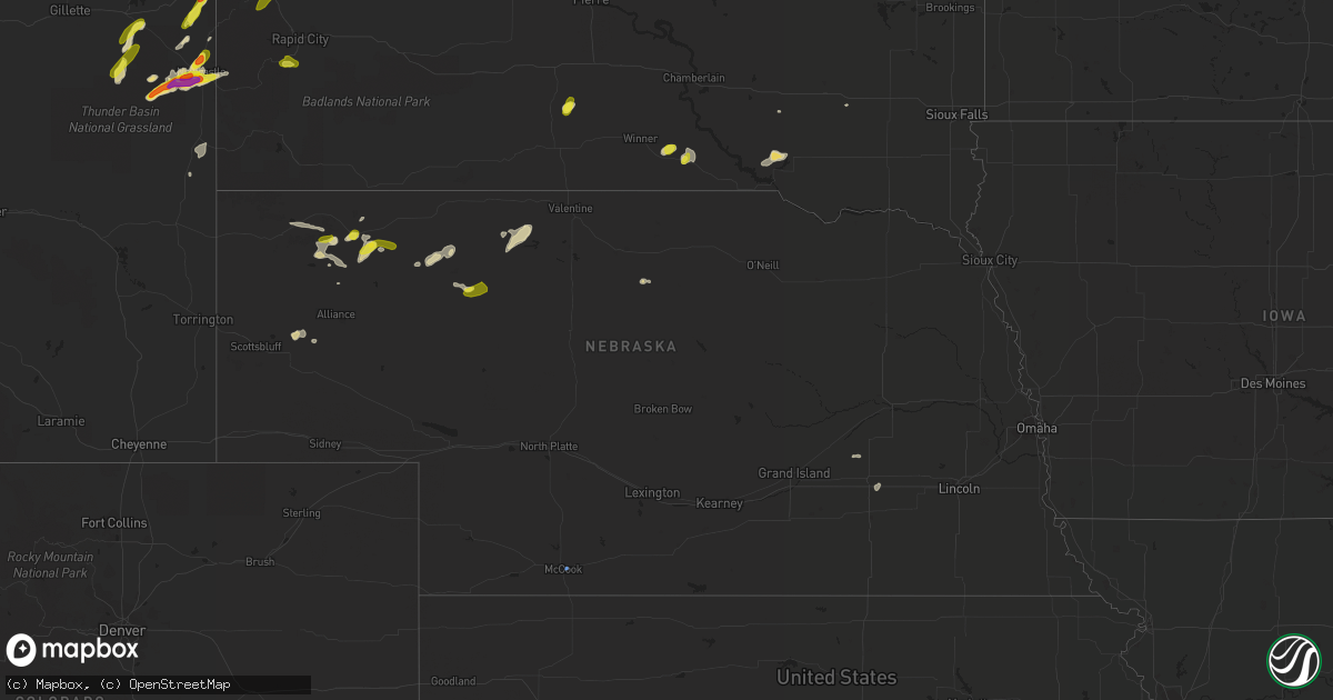
Hail Map in Nebraska on July 4, 2022
Get this storm
July 4 map
$229
one time, instant access
Download today. No call, no setup
Keep the $229
Bought the map and want the full workflow? Apply the entire $229 to a subscription within 7 days. None of it is wasted.
Every map, not just this one
This buys you this map. Subscription and you get every map we run, in the markets you choose from a few cities to whole states to nationwide. Plus real-time alerts the moment a storm fires.
Contact data
Name, contact info, occupancy, even credit band for addresses in the footprint. You go from where it hit to who to call.
Become the source they trust
Unlimited branding weather history reports on demand. You already have the documented answer ready for the property owner, and you are the one who showed up with it.
Property data and RoofTrace estimates
Pull up any address you have got, its value and the exact code rules for that jurisdiction, straight from One Click Code. Then RoofTrace estimates the squares, pitch, and roof value, priced the way you price.
Storm reports in Nebraska
Nebraska
| Date | Description |
|---|---|
| 07/04/20225:50 PM CDT | Mesonet station fw8225 sidney. |
| 07/04/20225:50 AM CDT | At 1049 PM CDT/949 PM MDT/, a severe thunderstorm was located 10 miles west of Merritt Reservoir, or 28 miles southwest of Valentine, moving northeast at 35 mph. HAZARD...60 mph wind gusts and quarter size hail. SOURCE...Radar indicated. IMPACT...Hail damage to vehicles is expected. Expect wind damage to roofs, siding, and trees. Locations impacted include... Kilgore, Nenzel, Merritt Reservoir, Crookston, Anderson Bridge State Wildlife Management Area, Schlagel Creek State Wildlife Management Area, Highway 97 crossing the Niobrara River and Big Alkali Lake State Wildlife Management Area.This includes the following highways... Highway 20 between mile markers 168 and 184. Highway 97 between mile markers 109 and 137. Highway 83 between mile markers 194 and 204. |
| 07/04/20223:41 AM CDT | At 840 PM MDT, a severe thunderstorm was located 19 miles southwest of Medicine Lake, or 26 miles southeast of Gordon, moving northeast at 30 mph. HAZARD...60 mph wind gusts and quarter size hail. SOURCE...Radar indicated. IMPACT...Hail damage to vehicles is expected. Expect wind damage to roofs, siding, and trees. Locations impacted include... Highway 61 Crossing The Niobrara River, Intersection of Highway 61 and Shadbolt Road, Indian Hill and Highway 61 crossing the Snake River.This includes the following highways... Highway 20 near mile marker 133. Highway 61 between mile markers 189 and 222. |
| 07/04/20222:37 AM CDT | At 737 PM CDT, a severe thunderstorm was located near McCook, moving east at 10 mph. HAZARD...70 mph wind gusts and penny size hail. SOURCE...Radar indicated. IMPACT...Expect considerable tree damage. Damage is likely to mobile homes, roofs, and outbuildings. Locations impacted include... Indianola. |
| 07/04/20221:12 AM CDT | At 612 PM MDT, a severe thunderstorm was located 10 miles southwest of Hay Springs, moving northeast at 20 mph. HAZARD...60 mph wind gusts and half dollar size hail. SOURCE...Radar indicated. IMPACT...Hail damage to vehicles is expected. Expect wind damage to roofs, siding, and trees. This severe thunderstorm will remain over mainly rural areas of southeastern Dawes County. |
| 07/03/20227:48 PM CDT | Corrects previous non-tstm wnd gst report from 2 e mccook. Asos station kmck mccook airport. |
| 07/03/20227:30 PM CDT | Sustained at 54 mph. |
| 07/03/20227:30 PM CDT | Reported via social media. Gusts of 60 mph continued over a duration of 15 minutes. |
| 07/03/20227:00 PM CDT | Chadron state park employee reports approximately 15 mins of hail...largest hail sizes reported over the phone were nickel to quarter sized. |
All States Impacted by Hail Map on July 4, 2022
Cities Impacted by Hail Map on July 4, 2022
- Denton, MT
- Lewistown, MT
- Cascade, MT
- Haviland, OH
- Gregory, SD
- Dallas, SD
- Armour, SD
- Geddes, SD
- Lake Andes, SD
- Hemingford, NE
- Hettinger, ND
- Hay Springs, NE
- Bradshaw, NE
- Benedict, NE
- Polk, NE
- Volborg, MT
- Leslie, GA
- Strawberry Point, IA
- Garber, IA
- Elkader, IA
- Volga, IA
- Guttenberg, IA
- Arlington, IA
- Edgewood, IA
- Colesburg, IA
- Wadena, IA
- Elkport, IA
- Fayette, IA
- Elgin, IA
- York, NE
- Hardin, MT
- Bighorn, MT
- Colstrip, MT
- Forsyth, MT
- Glendale Heights, IL
- Hanover Park, IL
- Carol Stream, IL
- West Chicago, IL
- Bloomingdale, IL
- Bartlett, IL
- Two Dot, MT
- Alliance, NE
- Roberts, IL
- Cottageville, SC
- Ridgeville, SC
- Lavina, MT
- Billings, MT
- Pecatonica, IL
- Winnebago, IL
- Newcastle, WY
- Ryegate, MT
- Shawmut, MT
- Harlowton, MT
- Osage, WY
- Laotto, IN
- Churubusco, IN
- Camp Crook, SD
- Baker, MT
- Ekalaka, MT
- Buffalo, SD
- Fredericksburg, IA
- Sumner, IA
- Ionia, IA
- Upton, WY
- Moorcroft, WY
- Custer, SD
- Valentine, NE
- Miles City, MT
- Livingston, MT
- Molt, MT
- Huntley, MT
- Ballantine, MT
- Rapelje, MT
- Wilsall, MT
- Worden, MT
- Pompeys Pillar, MT
- Big Timber, MT
- Acton, MT
- Shepherd, MT
- Melville, MT
- Broadview, MT
- Springfield, GA
- Gridley, IL
- Whitewater, WI
- Palmyra, WI
- Bowman, ND
- Scranton, ND
- Rosebud, MT
- Avilla, IN
- Albion, IN
- Columbia City, IN
- Fort Benton, MT
- Hanahan, SC
- Sundance, WY
- Beulah, WY
- Alexandria, SD
- Merriman, NE
- Whitney, NE
- Chadron, NE
- Bayard, NE
- Burke, SD
- Andersonville, GA
- Americus, GA
- Lodgepole, SD
- Whitman, NE
- Jonesboro, GA
- Keystone, SD
- Rapid City, SD
- Drummond, MT
- Clinton, MT
- Lance Creek, WY
- Paxton, IL
- Cissna Park, IL
- Loda, IL
- Rankin, IL
- Buckley, IL
- Hilger, MT
- Helena, MT
- Amidon, ND
- Jefferson, WI
- Stoughton, WI
- Fort Atkinson, WI
- Mcfarland, WI
- Cambridge, WI
- Cottage Grove, WI
- Deerfield, WI
- Otter, MT
- Fort Meade, SD
- Fort Valley, GA
- Perry, GA
- Marshallville, GA
- Maynard, IA
- Westgate, IA
- Prairie City, SD
- Moore, MT
- Putnam, IL
- Tiskilwa, IL
- Buda, IL
- Bradford, IL
- Hennepin, IL
- Princeton, IL
- Mark, IL
- Wyanet, IL
- Granville, IL
- Cody, NE
- Grass Range, MT
- Winnett, MT
- Forest Grove, MT
- Stickney, SD
- Aiken, SC
- Ridge Spring, SC
- Meridian, MS
- Rushville, NE
- Roundup, MT
- Mosby, MT
- Judith Gap, MT
- Sand Springs, MT
- Ingomar, MT
- Brusett, MT
- Cohagen, MT
- Reeder, ND
- Mott, ND
- Culver, IN
- Tonica, IL
- Peru, IL
- Lostant, IL
- Flaxville, MT
- Brockton, MT
- Barrington, IL
- Lake Zurich, IL
- Saint George, SC
- North Charleston, SC
- Ladson, SC
- Nashua, IA
- New Hampton, IA
- Ravenel, SC
- Adams Run, SC
- Randalia, IA
- Aurora, IA
- Oelwein, IA
- Lamont, IA
- Long Pine, NE
- Ainsworth, NE
- Poplar, MT
- Reserve, MT
- Scobey, MT
- Benson, IL
- Dodgeville, WI
- Mineral Point, WI
- Quitman, MS
- Rhame, ND
- Waterloo, IN
- Ismay, MT
- Auburn, IN
- Summerville, SC
- Angora, NE
- Penfield, IL
- Gifford, IL
- Rantoul, IL
- Albany, WI
- Monticello, WI
- Round O, SC
- Argyle, WI
- South Wayne, WI
- Monroe, WI
- Browntown, WI
- Darlington, WI
- Gratiot, WI
- Woodford, WI
- Chicago, IL
- Orangeville, IL
- Dakota, IL
- Durand, IL
- Wood, SD
- White River, SD
- Caledonia, IL
- Roscoe, IL
- Sycamore, IL
- Machesney Park, IL
- Burlington, IL
- Cherry Valley, IL
- Rockford, IL
- Garden Prairie, IL
- Poplar Grove, IL
- Marengo, IL
- Capron, IL
- Genoa, IL
- Harvard, IL
- Huntley, IL
- Union, IL
- Loves Park, IL
- Belvidere, IL
- Hampshire, IL
- Arlington Heights, IL
- Schaumburg, IL
- Des Plaines, IL
- Palatine, IL
- Streamwood, IL
- Elk Grove Village, IL
- Hoffman Estates, IL
- Mount Prospect, IL
- Rolling Meadows, IL
- Lancaster, WI
- Forrest, IL
- Fairbury, IL
- Graymont, IL
- Minonk, IL
- Pontiac, IL
- Flanagan, IL
- Rockton, IL
- Streator, IL
- Marsland, NE
- Burlington, WI
- Kansasville, WI
- East Troy, WI
- Rochester, WI
- Eagle, WI
- Waterford, WI
- Orfordville, WI
- Clinton, WI
- Beloit, WI
- Janesville, WI
- South Beloit, IL
- Park Ridge, IL
- Cary, IL
- Niles, IL
- Dundee, IL
- Algonquin, IL
- Fox River Grove, IL
- Crystal Lake, IL
- Carpentersville, IL
- Lake In The Hills, IL
- Colfax, IL
- Chenoa, IL
- Chatsworth, IL
- Wenona, IL
- Toluca, IL
- El Paso, IL
- Dana, IL
- Roanoke, IL
- Washburn, IL
- Ancona, IL
- Sibley, IL
- Cropsey, IL
- Long Point, IL
- Rutland, IL
- Belmont, WI
- Rock City, IL
- New Glarus, WI
- Belleville, WI
- Davis, IL
- Roselle, IL
- Hollandale, WI
- Lincolnwood, IL
- Wayne, IL
- Freeport, IL
- Saint Charles, IL
- Glenview, IL
- Winslow, IL
- Bensenville, IL
- Kirkland, IL
- Juda, WI
- Woodstock, IL
- Shirland, IL
- Morton Grove, IL
- Livingston, WI
- Afton, WI
- Kingston, IL
- Itasca, IL
- Wood Dale, IL
- Brodhead, WI
- Maple Park, IL
- Ridott, IL
- Medinah, IL
- Sharon, WI
- Fennimore, WI
- Evansville, WI
- Stitzer, WI
- Skokie, IL
- Elgin, IL
- Brooklyn, WI
- Harwood Heights, IL
- Rewey, WI
- South Elgin, IL
- Prospect Heights, IL
- Gilberts, IL
- Blanchardville, WI
- McConnell, IL
- Platteville, WI
- Holcomb, IL
- Stillman Valley, IL
- German Valley, IL
- Leaf River, IL
- Byron, IL
- Esmond, IL
- Lindenwood, IL
- Davis Junction, IL
- Monroe Center, IL
- Rochelle, IL
- Froid, MT
- Homestead, MT
- Medicine Lake, MT
- Springerville, AZ
- Deadwood, SD
- Sturgis, SD
- Mule Creek, NM
- Arcola, IN
- Fort Wayne, IN
- Larwill, IN
- Pierceton, IN
- Craigville, IN
- Ossian, IN
- Decatur, IN
- Malta, IL
- Chana, IL
- Wonder Lake, IL
- McCook, NE
- Marmarth, ND
- Plevna, MT
- Sentinel Butte, ND
- Spearfish, SD
- Reed Point, MT
- Broadus, MT
- Gordon, NE


