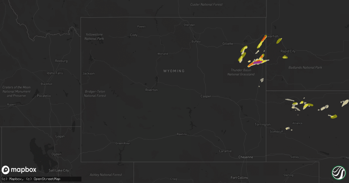
Hail Map in Wyoming on July 4, 2022
Get this storm
July 4 map
$229
one time, instant access
Download today. No call, no setup
Keep the $229
Bought the map and want the full workflow? Apply the entire $229 to a subscription within 7 days. None of it is wasted.
Every map, not just this one
This buys you this map. Subscription and you get every map we run, in the markets you choose from a few cities to whole states to nationwide. Plus real-time alerts the moment a storm fires.
Contact data
Name, contact info, occupancy, even credit band for addresses in the footprint. You go from where it hit to who to call.
Become the source they trust
Unlimited branding weather history reports on demand. You already have the documented answer ready for the property owner, and you are the one who showed up with it.
Property data and RoofTrace estimates
Pull up any address you have got, its value and the exact code rules for that jurisdiction, straight from One Click Code. Then RoofTrace estimates the squares, pitch, and roof value, priced the way you price.
Storm reports in Wyoming
Wyoming
| Date | Description |
|---|---|
| 07/04/20226:45 PM CDT | A local report indicates 1.25 inch wind near 8 N NEWCASTLE |
| 07/04/20221:44 AM CDT | At 644 PM MDT, a severe thunderstorm was located 9 miles southeast of Moorcroft, or 27 miles southwest of Sundance, moving northeast at 25 mph. HAZARD...60 mph wind gusts and quarter size hail. SOURCE...Radar indicated. IMPACT...Hail damage to vehicles is expected. Expect wind damage to roofs, siding, and trees. Locations impacted include... Pine Haven and eastern Keyhole Reservoir. This includes Interstate 90 in Wyoming between Mile Markers 158 and181. |
| 07/04/20221:12 AM CDT | At 612 PM MDT, a severe thunderstorm was located over Clareton, or 24 miles west of Newcastle, moving northeast at 15 mph. HAZARD...60 mph wind gusts and half dollar size hail. SOURCE...Radar indicated. IMPACT...Hail damage to vehicles is expected. Expect wind damage to roofs, siding, and trees. Locations impacted include... Clareton. |
| 07/04/202212:49 AM CDT | At 549 PM MDT, a severe thunderstorm was located 18 miles northwest of Clareton, or 27 miles east of Wright, moving northeast at 35 mph. HAZARD...Ping pong ball size hail and 60 mph wind gusts. SOURCE...Radar indicated. IMPACT...People and animals outdoors will be injured. Expect hail damage to roofs, siding, windows, and vehicles. Expect wind damage to roofs, siding, and trees. Locations impacted include... Upton, Pine Haven and southeastern Keyhole Reservoir. This includes Interstate 90 in Wyoming between Mile Markers 158 and169. |
| 07/03/20229:15 PM CDT | A local report indicates 1.00 inch wind near 8 ESE SUNDANCE |
| 07/03/20228:00 PM CDT | A local report indicates 1.00 inch wind near NEWCASTLE |
| 07/03/20227:27 PM CDT | Time estimated via radar |
| 07/03/20227:20 PM CDT | A local report indicates 1.00 inch wind near 1 E CLARETON |
| 07/03/20227:10 PM CDT | A local report indicates 1.00 inch wind near 19 SW UPTON |
All States Impacted by Hail Map on July 4, 2022
Cities Impacted by Hail Map on July 4, 2022
- Denton, MT
- Lewistown, MT
- Cascade, MT
- Haviland, OH
- Gregory, SD
- Dallas, SD
- Armour, SD
- Geddes, SD
- Lake Andes, SD
- Hemingford, NE
- Hettinger, ND
- Hay Springs, NE
- Bradshaw, NE
- Benedict, NE
- Polk, NE
- Volborg, MT
- Leslie, GA
- Strawberry Point, IA
- Garber, IA
- Elkader, IA
- Volga, IA
- Guttenberg, IA
- Arlington, IA
- Edgewood, IA
- Colesburg, IA
- Wadena, IA
- Elkport, IA
- Fayette, IA
- Elgin, IA
- York, NE
- Hardin, MT
- Bighorn, MT
- Colstrip, MT
- Forsyth, MT
- Glendale Heights, IL
- Hanover Park, IL
- Carol Stream, IL
- West Chicago, IL
- Bloomingdale, IL
- Bartlett, IL
- Two Dot, MT
- Alliance, NE
- Roberts, IL
- Cottageville, SC
- Ridgeville, SC
- Lavina, MT
- Billings, MT
- Pecatonica, IL
- Winnebago, IL
- Newcastle, WY
- Ryegate, MT
- Shawmut, MT
- Harlowton, MT
- Osage, WY
- Laotto, IN
- Churubusco, IN
- Camp Crook, SD
- Baker, MT
- Ekalaka, MT
- Buffalo, SD
- Fredericksburg, IA
- Sumner, IA
- Ionia, IA
- Upton, WY
- Moorcroft, WY
- Custer, SD
- Valentine, NE
- Miles City, MT
- Livingston, MT
- Molt, MT
- Huntley, MT
- Ballantine, MT
- Rapelje, MT
- Wilsall, MT
- Worden, MT
- Pompeys Pillar, MT
- Big Timber, MT
- Acton, MT
- Shepherd, MT
- Melville, MT
- Broadview, MT
- Springfield, GA
- Gridley, IL
- Whitewater, WI
- Palmyra, WI
- Bowman, ND
- Scranton, ND
- Rosebud, MT
- Avilla, IN
- Albion, IN
- Columbia City, IN
- Fort Benton, MT
- Hanahan, SC
- Sundance, WY
- Beulah, WY
- Alexandria, SD
- Merriman, NE
- Whitney, NE
- Chadron, NE
- Bayard, NE
- Burke, SD
- Andersonville, GA
- Americus, GA
- Lodgepole, SD
- Whitman, NE
- Jonesboro, GA
- Keystone, SD
- Rapid City, SD
- Drummond, MT
- Clinton, MT
- Lance Creek, WY
- Paxton, IL
- Cissna Park, IL
- Loda, IL
- Rankin, IL
- Buckley, IL
- Hilger, MT
- Helena, MT
- Amidon, ND
- Jefferson, WI
- Stoughton, WI
- Fort Atkinson, WI
- Mcfarland, WI
- Cambridge, WI
- Cottage Grove, WI
- Deerfield, WI
- Otter, MT
- Fort Meade, SD
- Fort Valley, GA
- Perry, GA
- Marshallville, GA
- Maynard, IA
- Westgate, IA
- Prairie City, SD
- Moore, MT
- Putnam, IL
- Tiskilwa, IL
- Buda, IL
- Bradford, IL
- Hennepin, IL
- Princeton, IL
- Mark, IL
- Wyanet, IL
- Granville, IL
- Cody, NE
- Grass Range, MT
- Winnett, MT
- Forest Grove, MT
- Stickney, SD
- Aiken, SC
- Ridge Spring, SC
- Meridian, MS
- Rushville, NE
- Roundup, MT
- Mosby, MT
- Judith Gap, MT
- Sand Springs, MT
- Ingomar, MT
- Brusett, MT
- Cohagen, MT
- Reeder, ND
- Mott, ND
- Culver, IN
- Tonica, IL
- Peru, IL
- Lostant, IL
- Flaxville, MT
- Brockton, MT
- Barrington, IL
- Lake Zurich, IL
- Saint George, SC
- North Charleston, SC
- Ladson, SC
- Nashua, IA
- New Hampton, IA
- Ravenel, SC
- Adams Run, SC
- Randalia, IA
- Aurora, IA
- Oelwein, IA
- Lamont, IA
- Long Pine, NE
- Ainsworth, NE
- Poplar, MT
- Reserve, MT
- Scobey, MT
- Benson, IL
- Dodgeville, WI
- Mineral Point, WI
- Quitman, MS
- Rhame, ND
- Waterloo, IN
- Ismay, MT
- Auburn, IN
- Summerville, SC
- Angora, NE
- Penfield, IL
- Gifford, IL
- Rantoul, IL
- Albany, WI
- Monticello, WI
- Round O, SC
- Argyle, WI
- South Wayne, WI
- Monroe, WI
- Browntown, WI
- Darlington, WI
- Gratiot, WI
- Woodford, WI
- Chicago, IL
- Orangeville, IL
- Dakota, IL
- Durand, IL
- Wood, SD
- White River, SD
- Caledonia, IL
- Roscoe, IL
- Sycamore, IL
- Machesney Park, IL
- Burlington, IL
- Cherry Valley, IL
- Rockford, IL
- Garden Prairie, IL
- Poplar Grove, IL
- Marengo, IL
- Capron, IL
- Genoa, IL
- Harvard, IL
- Huntley, IL
- Union, IL
- Loves Park, IL
- Belvidere, IL
- Hampshire, IL
- Arlington Heights, IL
- Schaumburg, IL
- Des Plaines, IL
- Palatine, IL
- Streamwood, IL
- Elk Grove Village, IL
- Hoffman Estates, IL
- Mount Prospect, IL
- Rolling Meadows, IL
- Lancaster, WI
- Forrest, IL
- Fairbury, IL
- Graymont, IL
- Minonk, IL
- Pontiac, IL
- Flanagan, IL
- Rockton, IL
- Streator, IL
- Marsland, NE
- Burlington, WI
- Kansasville, WI
- East Troy, WI
- Rochester, WI
- Eagle, WI
- Waterford, WI
- Orfordville, WI
- Clinton, WI
- Beloit, WI
- Janesville, WI
- South Beloit, IL
- Park Ridge, IL
- Cary, IL
- Niles, IL
- Dundee, IL
- Algonquin, IL
- Fox River Grove, IL
- Crystal Lake, IL
- Carpentersville, IL
- Lake In The Hills, IL
- Colfax, IL
- Chenoa, IL
- Chatsworth, IL
- Wenona, IL
- Toluca, IL
- El Paso, IL
- Dana, IL
- Roanoke, IL
- Washburn, IL
- Ancona, IL
- Sibley, IL
- Cropsey, IL
- Long Point, IL
- Rutland, IL
- Belmont, WI
- Rock City, IL
- New Glarus, WI
- Belleville, WI
- Davis, IL
- Roselle, IL
- Hollandale, WI
- Lincolnwood, IL
- Wayne, IL
- Freeport, IL
- Saint Charles, IL
- Glenview, IL
- Winslow, IL
- Bensenville, IL
- Kirkland, IL
- Juda, WI
- Woodstock, IL
- Shirland, IL
- Morton Grove, IL
- Livingston, WI
- Afton, WI
- Kingston, IL
- Itasca, IL
- Wood Dale, IL
- Brodhead, WI
- Maple Park, IL
- Ridott, IL
- Medinah, IL
- Sharon, WI
- Fennimore, WI
- Evansville, WI
- Stitzer, WI
- Skokie, IL
- Elgin, IL
- Brooklyn, WI
- Harwood Heights, IL
- Rewey, WI
- South Elgin, IL
- Prospect Heights, IL
- Gilberts, IL
- Blanchardville, WI
- McConnell, IL
- Platteville, WI
- Holcomb, IL
- Stillman Valley, IL
- German Valley, IL
- Leaf River, IL
- Byron, IL
- Esmond, IL
- Lindenwood, IL
- Davis Junction, IL
- Monroe Center, IL
- Rochelle, IL
- Froid, MT
- Homestead, MT
- Medicine Lake, MT
- Springerville, AZ
- Deadwood, SD
- Sturgis, SD
- Mule Creek, NM
- Arcola, IN
- Fort Wayne, IN
- Larwill, IN
- Pierceton, IN
- Craigville, IN
- Ossian, IN
- Decatur, IN
- Malta, IL
- Chana, IL
- Wonder Lake, IL
- McCook, NE
- Marmarth, ND
- Plevna, MT
- Sentinel Butte, ND
- Spearfish, SD
- Reed Point, MT
- Broadus, MT
- Gordon, NE


