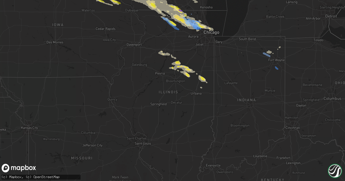
Hail Map in Illinois on July 4, 2022
Get this storm
July 4 map
$229
one time, instant access
Download today. No call, no setup
Keep the $229
Bought the map and want the full workflow? Apply the entire $229 to a subscription within 7 days. None of it is wasted.
Every map, not just this one
This buys you this map. Subscription and you get every map we run, in the markets you choose from a few cities to whole states to nationwide. Plus real-time alerts the moment a storm fires.
Contact data
Name, contact info, occupancy, even credit band for addresses in the footprint. You go from where it hit to who to call.
Become the source they trust
Unlimited branding weather history reports on demand. You already have the documented answer ready for the property owner, and you are the one who showed up with it.
Property data and RoofTrace estimates
Pull up any address you have got, its value and the exact code rules for that jurisdiction, straight from One Click Code. Then RoofTrace estimates the squares, pitch, and roof value, priced the way you price.
Storm reports in Illinois
Illinois
| Date | Description |
|---|---|
| 07/04/20226:59 PM CDT | Power lines downed. |
| 07/04/20226:25 PM CDT | Delayed report. Measured 75 mph wind gust. Relayed by wcia-tv. Time estimated. |
| 07/04/20226:25 PM CDT | Delayed report. Two power poles down and corn flattened. Time estimated. Relayed by wcia-tv. |
| 07/04/20226:15 PM CDT | Power lines down. Time estimated by radar. |
| 07/04/20225:45 PM CDT | Photos shared via social media show numerous small branches downed in multiple locations across buckley. Some branches at least a couple inches in diameter. |
| 07/04/20225:23 PM CDT | Report of tree downed onto power line in gibson city. Relayed via broadcast media. Time estimated by radar. |
| 07/04/20225:10 PM CDT | Photo shared via social media shows flattened corn south of cissna park. Time estimated by radar. |
| 07/04/20224:40 PM CDT | Measured gust at 60 mph... Minor tree damage with 2 inch branches down. |
| 07/04/20224:26 PM CDT | Picture of large tree down relayed via social media. Tree does appear to be unhealthy. |
| 07/04/20224:22 PM CDT | Media reports several poles down and a barn collapsed. |
| 07/04/20224:06 PM CDT | Report of tree limbs down relayed by media. |
| 07/04/20224:01 PM CDT | Several spotter reports of estimated 60 mph wind gusts and corn blown over. |
| 07/04/20224:00 PM CDT | High tensile fence destroyed... Numerous trees blown down... And several windows blown in on outbuildings. Machine shed destroyed. Reported relayed via social media. |
| 07/04/20223:43 PM CDT | Report relayed by media of several trees down along east indiana ave. |
| 07/04/20223:41 PM CDT | Media relayed report of several tree branches down... One of which fell on a car. |
| 07/04/20223:39 PM CDT | Spotter reports part of a barn roof was blown off and several twigs blown around. Time estimated from radar. |
| 07/04/20223:35 PM CDT | Report of uprooted/split trees as well as multiple power lines down in pontiac. Time estimated based on radar and social media report. |
| 07/04/20223:26 PM CDT | 8 inch diameter limb down on washington street in ridott. Time estimated based off of radar. |
| 07/04/20222:50 PM CDT | 8 to 12 inch diameter based on photo shared on social media. Time of the event was estimated using radar. |
| 07/04/20222:30 PM CDT | Tree branches downed in peru. Time estimated by radar. |
| 07/04/20222:30 PM CDT | Tree branches downed in cedar point. Time estimated by radar. |
| 07/04/20222:30 PM CDT | Garage door damaged along with a few trees down on property. Erratic corn damage in fields near residence. Possible tornado damage. |
| 07/04/20222:30 PM CDT | Highest wind lasted 5 min... With winds over 55 mph lasting approx. 10 min. Torrential rain occurred during entire time. |
| 07/04/20222:30 PM CDT | Garage door damaged along with a few trees down. Broad area of heavily leaning corn to the west... East... And south of property. Corrects previous tstm wnd dmg report |
| 07/04/20221:57 PM CDT | 12 inch diameter tree down. Relayed by lot. |
| 07/04/20226:58 AM CDT | At 1158 PM CDT, numerous severe thunderstorm were located from Hampshire to Elgin, all moving southeast at 40 mph. HAZARD...60 mph wind gusts. SOURCE...Radar indicated. IMPACT...Expect damage to roofs, siding, and trees. Locations impacted include... Elgin, Arlington Heights, Schaumburg, Palatine, Des Plaines, Mount Prospect, Wheaton, Hoffman Estates, Downers Grove, Elmhurst, Lombard, Buffalo Grove, Bartlett, Streamwood, Carol Stream, Hanover Park, Carpentersville, Wheeling, Addison and Glendale Heights.Including the following interstates... I-88 between mile markers 134 and 139. I-90 between mile markers 56 and 74. I-290 between mile markers 1 and 15. I-355 between mile markers 23 and 30.This includes... Schaumburg Boomers Baseball, College of DuPage,DuPage County Fairgrounds, Elgin Community College, Harper College,and Wheaton College. |
| 07/04/20226:51 AM CDT | At 1150 PM CDT, a severe thunderstorm was located over Schaumburg, moving southeast at 30 mph. HAZARD...60 mph wind gusts and quarter size hail. SOURCE...Radar indicated. IMPACT...Hail damage to vehicles is expected. Expect wind damage to roofs, siding, and trees. Locations impacted include... Chicago, Cicero, Schaumburg, Berwyn, Oak Park, Elmhurst, Ohare Airport, Addison, Elk Grove Village, West Town, Austin, Bridgeport, Chicago Loop, South Lawndale, Lincoln Park, Irving Park, Melrose Park, Maywood, Brookfield and Franklin Park.Including the following interstates... I-55 between mile markers 288 and 294. I-88 near mile marker 140. I-94 between mile markers 47 and 56. I-290 between mile markers 3 and 29. I-294 between mile markers 47 and 56.This includes... Brookfield Zoo, Triton College, Hawthorne Park,Soldier Field, University of Illinois Chicago, Guaranteed RateField...IL Institute of Technology, The Loop, Museum Campus, andNortherly Island. |
| 07/04/20226:22 AM CDT | At 1122 PM CDT, a severe thunderstorm was located near Poplar Grove, moving southeast at 30 mph. HAZARD...60 mph wind gusts. SOURCE...Radar indicated. IMPACT...Expect damage to roofs, siding, and trees. Locations impacted include... Elgin, Crystal Lake, Carpentersville, Algonquin, Lake in the Hills, McHenry, Woodstock, Huntley, Island Lake, Marengo, Cary, Pingree Grove, Gilberts, West Dundee, Hampshire, Fox River Grove, Barrington Hills, Lakewood, Sleepy Hollow and East Dundee.Including the following interstate... I-90 between mile markers 32 and 56. This includes... Mchenry County College, Mchenry County Fairgrounds,and Moraine Hills State Park. |
| 07/04/20226:16 AM CDT | At 1115 PM CDT, a severe thunderstorm was located over Barrington, moving east at 40 mph. HAZARD...60 mph wind gusts. SOURCE...Trained weather spotters. A 64 mph wind gust was measured in Wonder Lake with this storm! IMPACT...Expect damage to roofs, siding, and trees. Locations impacted include... Chicago, Arlington Heights, Evanston, Schaumburg, Palatine, Skokie, Des Plaines, Mount Prospect, Hoffman Estates, Glenview, Buffalo Grove, Ohare Airport, Streamwood, Wheeling, Park Ridge, Northbrook, Elk Grove Village, North Chicago, Mundelein and Niles.Including the following interstates... I-90 between mile markers 59 and 84. I-94 between mile markers 15 and 46. I-290 between mile markers 1 and 3. I-294 between mile markers 15 and 46.This includes... Lincoln Park Zoo, Loyola University, OaktonCommunity College, Harper College, Lake Forest College, NortheasternIllinois University, Northwestern University, Ravinia Music Festival,and Wrigley Field. |
| 07/04/20226:04 AM CDT | At 1104 PM CDT, a severe thunderstorm was located over Loves Park, moving southeast at 25 mph. HAZARD...60 mph wind gusts. SOURCE...Radar indicated. IMPACT...Expect damage to roofs, siding, and trees. Locations impacted include... Rockford, Belvidere, Loves Park, Machesney Park, Roscoe, Poplar Grove, Candlewick Lake, Cherry Valley, Timberlane, Garden Prairie and Caledonia.Including the following interstates... I-39 between mile markers 121 and 123. I-90 between mile markers 5 and 31.This includes... Boone County Fairgrounds, Rock Cut State Park, RockValley College, Rockford Rivets Baseball, and Rockford Speedway. |
| 07/04/20225:55 AM CDT | At 1055 PM CDT, a severe thunderstorm was located over Lakewood, or near Crystal Lake, moving southeast at 25 mph. HAZARD...60 mph wind gusts. SOURCE...Radar indicated. IMPACT...Expect damage to roofs, siding, and trees. Locations impacted include... Elgin, Hoffman Estates, Crystal Lake, Carpentersville, Mundelein, Algonquin, Lake in the Hills, McHenry, Woodstock, Huntley, Grayslake, Libertyville, Lake Zurich, Round Lake, Wauconda, Barrington, Island Lake, Cary, Gilberts and Hawthorn Woods.Including the following interstate... I-90 between mile markers 55 and 58. This includes... Lake County IL Fairgrounds, Mchenry County College,Mchenry County Fairgrounds, and Moraine Hills State Park. |
| 07/04/20225:42 AM CDT | At 1042 PM CDT, severe thunderstorms were located along a line extending from near Lake Summerset to Buena Vista, moving southeast at 30 mph. HAZARD...60 mph wind gusts and quarter size hail. SOURCE...Radar indicated. IMPACT...Hail damage to vehicles is expected. Expect wind damage to roofs, siding, and trees. Locations impacted include... Freeport, Cedarville, Davis, Dakota, German Valley, Rock City, Ridott, Buena Vista, Rock Grove, Oneco, Orangeville, Red Oak, Afolkey, Winneshiek, Dakota Dornink Airport and Lake Summerset. |
| 07/04/20225:10 AM CDT | At 1010 PM CDT, a severe thunderstorm was located near Argyle, or 9 miles west of Monroe, moving southeast at 25 mph. HAZARD...60 mph wind gusts and nickel size hail. SOURCE...Radar indicated. IMPACT...Expect damage to roofs, siding, and trees. Locations impacted include... Monroe, Browntown and Jordan Center. |
| 07/04/20225:05 AM CDT | At 1005 PM CDT, a severe thunderstorm was located over Capron, or near Poplar Grove, moving southeast at 25 mph. HAZARD...60 mph wind gusts. SOURCE...Radar indicated. IMPACT...Expect damage to roofs, siding, and trees. Locations impacted include... Woodstock, Harvard, Marengo, Capron, Hebron, Union and Chemung. |
| 07/04/20224:19 AM CDT | At 919 PM CDT, a severe thunderstorm was located near Argyle, or 8 miles northwest of Monroe, moving southeast at 30 mph. HAZARD...60 mph wind gusts and quarter size hail. SOURCE...Radar indicated. IMPACT...Hail damage to vehicles is expected. Expect wind damage to roofs, siding, and trees. Locations impacted include... Monroe, Brodhead, Browntown, Juda and Jordan Center. |
| 07/04/20224:11 AM CDT | At 911 PM CDT, a severe thunderstorm was located near Footville, or near Janesville, moving east at 25 mph. HAZARD...60 mph wind gusts and quarter size hail. SOURCE...Radar indicated. IMPACT...Hail damage to vehicles is expected. Expect wind damage to roofs, siding, and trees. Locations impacted include... Janesville, Beloit, South Beloit, Clinton, Tiffany, Hanover, Foxhollow, Avalon, Afton, Shopiere and Emerald Grove. |
| 07/04/20223:32 AM CDT | At 832 PM CDT, a severe thunderstorm was located near Beloit, moving southeast at 35 mph. HAZARD...60 mph wind gusts and quarter size hail. This storm is also exhibiting weak low-level rotation. SOURCE...Radar indicated. IMPACT...Hail damage to vehicles is expected. Expect wind damage to roofs, siding, and trees. Locations impacted include... Beloit, Roscoe, Harvard, South Beloit, Rockton, Poplar Grove, Candlewick Lake, Sharon, Capron, Hebron, Timberlane, Garden Prairie, Chemung and Caledonia.Including the following interstate... I-90 between mile markers 0 and 5. |
| 07/04/20223:27 AM CDT | At 827 PM CDT, a severe thunderstorm was located near Beloit, moving southeast at 30 mph. HAZARD...60 mph wind gusts and quarter size hail. SOURCE...Radar indicated. IMPACT...Hail damage to vehicles is expected. Expect wind damage to roofs, siding, and trees. Locations impacted include... Janesville, Beloit, South Beloit, Walworth, Clinton, Fontana-On-Geneva Lake, Sharon, Darien, Tiffany, Allens Grove, Avalon, Afton, Shopiere, Emerald Grove, Foxhollow and Delavan Lake.People attending ABC Supply Stadium should seek safe shelterimmediately! |
| 07/04/20222:48 AM CDT | At 748 PM CDT, a severe thunderstorm was located over Orfordville, or 7 miles east of Brodhead, moving southeast at 25 mph. HAZARD...60 mph wind gusts and quarter size hail. SOURCE...Radar indicated. IMPACT...Hail damage to vehicles is expected. Expect wind damage to roofs, siding, and trees. Locations impacted include... Janesville, Beloit, South Beloit, Orfordville, Footville, Tiffany, Hanover, Avalon, Afton and Shopiere.People attending ABC Supply Stadium should seek safe shelterimmediately! |
| 07/04/20222:19 AM CDT | Report of multiple tree branches and limbs downed near higgins road and jones road in schaumburg. Also damage to a fence and connected brick wall. Time estimated by rad |
| 07/04/202212:44 AM CDT | At 543 PM CDT, a severe thunderstorm was located over Aurora, moving southeast at 30 mph. HAZARD...60 mph wind gusts and quarter size hail. SOURCE...Radar indicated. IMPACT...Hail damage to vehicles is expected. Expect wind damage to roofs, siding, and trees. Locations impacted include... Aurora, Joliet, Naperville, Bolingbrook, Orland Park, Downers Grove, Romeoville, Plainfield, Woodridge, Oswego, Lockport, New Lenox, Homer Glen, Palos Hills, Yorkville, Lemont, Burr Ridge, Lisle, Darien and Crest Hill.Including the following interstates... I-55 between mile markers 255 and 273. I-80 between mile markers 131 and 140. I-88 between mile markers 118 and 125. I-355 between mile markers 1 and 16.This includes... Argonne National Laboratory, University of St.Francis, Aurora University, Benedictine University, ChicagolandSpeedway...Route 66 Raceway, Joliet Slammers Baseball, LewisUniversity, and North Central College. |
| 07/04/202212:42 AM CDT | Numerous small branches downed across southern downers grove. |
| 07/04/202212:29 AM CDT | 61 mph wind gust measured by handheld anemometer. |
| 07/04/202212:25 AM CDT | Photo relayed via social media of roof damage to an apartment building in park ridge. Time estimated based on radar and report. |
| 07/04/202212:25 AM CDT | Photo shared via social media shows large tree uprooted in niles. Location approximate. Time estimated by radar. |
| 07/04/202212:21 AM CDT | Photo shared via social media shows large tree limb downed in schaumburg. Location estimated. Time estimated by radar. |
| 07/04/202212:21 AM CDT | Reports received of multiple large power poles snapped along keslinger road near dauberman road. Poles snapped from north to south. Time estimated by radar. |
| 07/04/202212:12 AM CDT | At 512 PM CDT, severe thunderstorms were located along a line extending from near Hoopeston to Rankin to near Paxton, moving southeast at 25 mph. HAZARD...60 mph wind gusts. SOURCE...Radar indicated. IMPACT...Expect damage to roofs, siding, and trees. Severe thunderstorms will be near... Hoopeston around 520 PM CDT.Other locations in the path of these severe thunderstorms includeRossville. |
| 07/04/202212:10 AM CDT | Extensive tree damage across the elgin historic area with uprooting and trees on houses. Time estimated based on radar. Relayed via social media. |
| 07/04/202212:10 AM CDT | Tree damage near landmeier road and tonne road in elk grove village. Relayed via social media. Time estimated by radar. |
| 07/04/202212:04 AM CDT | Industrial building damaged by thunderstorm winds. Time estimated based on radar. |
| 07/04/202212:04 AM CDT | Several homes and buildings damaged in the vicinity of jarvis and louis avenue. Time estimated based on radar. |
| 07/04/202212:02 AM CDT | Photo shared via social media shows large tree downed onto fence in hampshire. Location approximate. Time estimated by radar. |
| 07/04/202212:00 AM CDT | Large oak tree snapped at the base near sleepy hollow. Time estimated based on radar. |
| 07/03/202211:59 PM CDT | At 458 PM CDT, a severe thunderstorm was located near Colfax, or 8 miles south of Fairbury, moving southeast at 25 mph. HAZARD...60 mph wind gusts. SOURCE...Radar indicated. IMPACT...Expect damage to roofs, siding, and trees. This severe thunderstorm will remain over mainly rural areas of northeastern McLean County, including the following locations... Cropsey and Anchor. |
| 07/03/202211:49 PM CDT | At 449 PM CDT, a severe thunderstorm was located near Fairbury, moving southeast at 25 mph. HAZARD...60 mph wind gusts and quarter size hail. SOURCE...Radar indicated. IMPACT...Hail damage to vehicles is expected. Expect wind damage to roofs, siding, and trees. Locations impacted include... Paxton, Gibson City, Melvin, Roberts, Elliott and Sibley. Including the following interstate... I-57 near mile marker 258. |
| 07/03/202211:34 PM CDT | At 434 PM CDT, a severe thunderstorm was located near Chenoa, or near Fairbury, moving east at 30 mph. HAZARD...60 mph wind gusts and quarter size hail. SOURCE...Radar indicated. IMPACT...Hail damage to vehicles is expected. Expect wind damage to roofs, siding, and trees. Locations impacted include... Fairbury, Forrest and Strawn. Including the following interstate... I-55 between mile markers 189 and 191. |
| 07/03/202211:32 PM CDT | At 432 PM CDT, a severe thunderstorm was located near Piper City, or 7 miles southeast of Chatsworth, moving southeast at 30 mph. HAZARD...60 mph wind gusts. SOURCE...Trained weather spotters. IMPACT...Expect damage to roofs, siding, and trees. Locations impacted include... Chatsworth, Piper City and Roberts. |
| 07/03/202211:30 PM CDT | At 429 PM CDT, severe thunderstorms were located along a line extending from near Fairbury to near Lexington, moving east at 30 mph. HAZARD...60 mph wind gusts and quarter size hail. SOURCE...Radar indicated. IMPACT...Hail damage to vehicles is expected. Expect wind damage to roofs, siding, and trees. Severe thunderstorms will be near... Colfax around 445 PM CDT.This includes Interstate 55 between mile markers 180 and 187. |
| 07/03/202211:25 PM CDT | Photo shows damage to grain bins and agricultural structures near garden prairie. Relayed via broadcast media. Location approximate. Time estimated by radar. |
| 07/03/202211:20 PM CDT | Large tree blocking road. Old sutton road and il route 72 higgins road. Via hanover township emergency management. |
| 07/03/202211:18 PM CDT | Report of trees down on garden prairie road. Time estimated based on radar and call time. |
| 07/03/202211:16 PM CDT | At 416 PM CDT, a severe thunderstorm was located near Chatsworth, moving southeast at 25 mph. This storm has a history of producing wind damage! HAZARD...60 mph wind gusts. SOURCE...Trained weather spotters. IMPACT...Expect damage to roofs, siding, and trees. Locations impacted include... Paxton, Gilman, Onarga, Cissna Park, Buckley, Melvin, Loda, Roberts, Thawville, Clarence and Claytonville.Including the following interstate... I-57 between mile markers 258 and 282. |
| 07/03/202211:16 PM CDT | Report of several trees down near russellville and grange hall roads. Time estimated based on radar and time of report call. |
| 07/03/202211:10 PM CDT | Ten inch diameter tree down across road. Rohrssen road and cardinal lane. Time estimated from radar. Via hanover township emergency management. |
| 07/03/202211:07 PM CDT | At 407 PM CDT, a severe thunderstorm was located over Davis Junction, or just south of the Rockford Airport, moving southeast at 25 mph. A trained spotter earlier reported wind damage near Seward. HAZARD...60 mph wind gusts and quarter size hail. SOURCE...Trained weather spotters. IMPACT...Hail damage to vehicles is expected. Expect wind damage to roofs, siding, and trees. Locations impacted include... DeKalb, Sycamore, Rochelle, Genoa, Cortland, Kirkland, Hillcrest, Maple Park, Kingston, Malta, Creston, Lindenwood, Monroe Center, Fairdale and Kings.Including the following interstates... I-39 between mile markers 98 and 112. I-88 between mile markers 79 and 101.This includes... Northern Illinois University. |
| 07/03/202211:05 PM CDT | Multiple large 1.5-2 foot diameter trees snapped or uprooted along crystal lake avenue. Time estimated based on radar. |
| 07/03/202211:00 PM CDT | Large tree down across road at wakefield and il route 68. Time approximate from radar. Via hanover township emergency management. |
| 07/03/202210:50 PM CDT | Private weather station recorded 64mph wind gust west of wonder lake. Time estimated by radar. |
| 07/03/202210:44 PM CDT | At 343 PM CDT, numerous severe thunderstorms was located over southwestern livingston county from Benson to Flanagan, moving east at 25 to 30 mph. HAZARD...60 mph wind gusts. SOURCE...Radar indicated. IMPACT...Expect damage to roofs, siding, and trees. Locations impacted include... Pontiac, Chenoa, Gridley and Flanagan. Including the following interstate... I-55 between mile markers 188 and 206. |
| 07/03/202210:34 PM CDT | At 334 PM CDT, a severe thunderstorm was located near German Valley, or 11 miles northwest of Byron, moving southeast at 30 mph. HAZARD...60 mph wind gusts and half dollar size hail. SOURCE...Radar indicated. IMPACT...Hail damage to vehicles is expected. Expect wind damage to roofs, siding, and trees. Locations impacted include... Rockford, Byron, Rockford Airport, Cherry Valley, Winnebago, Davis Junction, Pecatonica, Stillman Valley, New Milford, Monroe Center, Leaf River, Seward and Kings.Including the following interstates... I-39 between mile markers 109 and 123. I-90 near mile marker 18.This includes... Winnebago County Fairgrounds. |
| 07/03/202210:31 PM CDT | At 331 PM CDT, a severe thunderstorm was located over Pontiac, moving east at 30 mph. HAZARD...60 mph wind gusts and quarter size hail. SOURCE...Radar indicated. IMPACT...Hail damage to vehicles is expected. Expect wind damage to roofs, siding, and trees. Locations impacted include... Fairbury, Chatsworth, Forrest, Piper City, Cullom, Saunemin and Kempton. |
| 07/03/202210:24 PM CDT | At 323 PM CDT, a severe thunderstorm was located near Minonk, or 13 miles northeast of Eureka, moving northeast at 25 mph. HAZARD...60 mph wind gusts and quarter size hail. SOURCE...Radar indicated. IMPACT...Hail damage to vehicles is expected. Expect wind damage to roofs, siding, and trees. This severe thunderstorm will be near... Minonk around 340 PM CDT.This includes Interstate 39 between mile markers 21 and 31. |
| 07/03/202210:12 PM CDT | At 312 PM CDT, a severe thunderstorm was located near Flanagan, or near Pontiac, moving east at 30 mph. HAZARD...60 mph wind gusts and quarter size hail. SOURCE...Radar indicated. IMPACT...Hail damage to vehicles is expected. Expect wind damage to roofs, siding, and trees. Locations impacted include... Pontiac and Flanagan. Including the following interstate... I-55 between mile markers 190 and 206. |
| 07/03/20229:40 PM CDT | At 240 PM CDT, a severe thunderstorm was located near Wenona, or 11 miles southwest of Streator, moving east at 30 mph. HAZARD...Ping pong ball size hail and 60 mph wind gusts. SOURCE...Radar indicated. IMPACT...People and animals outdoors will be injured. Expect hail damage to roofs, siding, windows, and vehicles. Expect wind damage to roofs, siding, and trees. Locations impacted include... Streator, Pontiac, Wenona, South Streator, Cornell, Ransom, Rutland, Long Point and Dana.Including the following interstate... I-55 between mile markers 197 and 201. |
| 07/03/20229:30 PM CDT | At 230 PM CDT, a severe thunderstorm was located over South Wayne, or 13 miles southeast of Darlington, moving east southeast at 50 mph. HAZARD...60 mph wind gusts. SOURCE...Trained weather spotters. IMPACT...Expect damage to roofs, siding, and trees. Locations impacted include... Freeport, Lena, Cedarville, Davis, Dakota, German Valley, Winslow, Rock City, Ridott, Buena Vista, Rock Grove, Oneco, Orangeville, Eleroy, Damascus, Lake Le-Aqua- na State Park, Mc Connell, Scioto Mills, Winneshiek and Stephenson County Fairgrounds. |
| 07/03/20229:28 PM CDT | At 228 PM CDT, a severe thunderstorm was located over McNabb, or 7 miles southeast of Hennepin, moving east at 25 mph. HAZARD...60 mph wind gusts. SOURCE...Radar indicated. IMPACT...Expect damage to roofs, siding, and trees. Locations impacted include... Hennepin, Henry, Granville, McNabb, Putnam, Mark, Magnolia, Standard, Lake Thunderbird and Florid. |
| 07/03/20229:05 PM CDT | At 204 PM CDT, a severe thunderstorm was located over Bureau Junction, or near Hennepin, moving east at 25 mph. HAZARD...60 mph wind gusts and quarter size hail. SOURCE...Radar indicated. IMPACT...Hail damage to vehicles is expected. Expect wind damage to roofs, siding, and trees. Locations impacted include... Ottawa, Peru, La Salle, Spring Valley, Oglesby, North Utica, Wenona, Tonica, Grand Ridge, Naplate, Lostant, Cedar Point, Kangley and Leonore.Including the following interstates... I-39 between mile markers 41 and 58. I-80 between mile markers 73 and 75.This includes... Buffalo Rock State Park, Illinois Valley CommunityCollege, Matthiessen State Park, and Starved Rock State Park. |
| 07/03/20228:57 PM CDT | At 157 PM CDT, a severe thunderstorm was located over Tiskilwa, or 7 miles west of Hennepin, moving east at 20 mph. HAZARD...60 mph wind gusts and quarter size hail. SOURCE...Radar indicated. IMPACT...Hail damage to vehicles is expected. Expect wind damage to roofs, siding, and trees. Locations impacted include... Princeton, Hennepin, Spring Valley, DePue, Granville, Tiskilwa, Dalzell, Bureau Junction, McNabb, Putnam, Mark, Seatonville, Magnolia, Standard, Spring Valley Airport, Ottville, Lake Thunderbird, Florid and Lone Tree Corners. |
All States Impacted by Hail Map on July 4, 2022
Cities Impacted by Hail Map on July 4, 2022
- Denton, MT
- Lewistown, MT
- Cascade, MT
- Haviland, OH
- Gregory, SD
- Dallas, SD
- Armour, SD
- Geddes, SD
- Lake Andes, SD
- Hemingford, NE
- Hettinger, ND
- Hay Springs, NE
- Bradshaw, NE
- Benedict, NE
- Polk, NE
- Volborg, MT
- Leslie, GA
- Strawberry Point, IA
- Garber, IA
- Elkader, IA
- Volga, IA
- Guttenberg, IA
- Arlington, IA
- Edgewood, IA
- Colesburg, IA
- Wadena, IA
- Elkport, IA
- Fayette, IA
- Elgin, IA
- York, NE
- Hardin, MT
- Bighorn, MT
- Colstrip, MT
- Forsyth, MT
- Glendale Heights, IL
- Hanover Park, IL
- Carol Stream, IL
- West Chicago, IL
- Bloomingdale, IL
- Bartlett, IL
- Two Dot, MT
- Alliance, NE
- Roberts, IL
- Cottageville, SC
- Ridgeville, SC
- Lavina, MT
- Billings, MT
- Pecatonica, IL
- Winnebago, IL
- Newcastle, WY
- Ryegate, MT
- Shawmut, MT
- Harlowton, MT
- Osage, WY
- Laotto, IN
- Churubusco, IN
- Camp Crook, SD
- Baker, MT
- Ekalaka, MT
- Buffalo, SD
- Fredericksburg, IA
- Sumner, IA
- Ionia, IA
- Upton, WY
- Moorcroft, WY
- Custer, SD
- Valentine, NE
- Miles City, MT
- Livingston, MT
- Molt, MT
- Huntley, MT
- Ballantine, MT
- Rapelje, MT
- Wilsall, MT
- Worden, MT
- Pompeys Pillar, MT
- Big Timber, MT
- Acton, MT
- Shepherd, MT
- Melville, MT
- Broadview, MT
- Springfield, GA
- Gridley, IL
- Whitewater, WI
- Palmyra, WI
- Bowman, ND
- Scranton, ND
- Rosebud, MT
- Avilla, IN
- Albion, IN
- Columbia City, IN
- Fort Benton, MT
- Hanahan, SC
- Sundance, WY
- Beulah, WY
- Alexandria, SD
- Merriman, NE
- Whitney, NE
- Chadron, NE
- Bayard, NE
- Burke, SD
- Andersonville, GA
- Americus, GA
- Lodgepole, SD
- Whitman, NE
- Jonesboro, GA
- Keystone, SD
- Rapid City, SD
- Drummond, MT
- Clinton, MT
- Lance Creek, WY
- Paxton, IL
- Cissna Park, IL
- Loda, IL
- Rankin, IL
- Buckley, IL
- Hilger, MT
- Helena, MT
- Amidon, ND
- Jefferson, WI
- Stoughton, WI
- Fort Atkinson, WI
- Mcfarland, WI
- Cambridge, WI
- Cottage Grove, WI
- Deerfield, WI
- Otter, MT
- Fort Meade, SD
- Fort Valley, GA
- Perry, GA
- Marshallville, GA
- Maynard, IA
- Westgate, IA
- Prairie City, SD
- Moore, MT
- Putnam, IL
- Tiskilwa, IL
- Buda, IL
- Bradford, IL
- Hennepin, IL
- Princeton, IL
- Mark, IL
- Wyanet, IL
- Granville, IL
- Cody, NE
- Grass Range, MT
- Winnett, MT
- Forest Grove, MT
- Stickney, SD
- Aiken, SC
- Ridge Spring, SC
- Meridian, MS
- Rushville, NE
- Roundup, MT
- Mosby, MT
- Judith Gap, MT
- Sand Springs, MT
- Ingomar, MT
- Brusett, MT
- Cohagen, MT
- Reeder, ND
- Mott, ND
- Culver, IN
- Tonica, IL
- Peru, IL
- Lostant, IL
- Flaxville, MT
- Brockton, MT
- Barrington, IL
- Lake Zurich, IL
- Saint George, SC
- North Charleston, SC
- Ladson, SC
- Nashua, IA
- New Hampton, IA
- Ravenel, SC
- Adams Run, SC
- Randalia, IA
- Aurora, IA
- Oelwein, IA
- Lamont, IA
- Long Pine, NE
- Ainsworth, NE
- Poplar, MT
- Reserve, MT
- Scobey, MT
- Benson, IL
- Dodgeville, WI
- Mineral Point, WI
- Quitman, MS
- Rhame, ND
- Waterloo, IN
- Ismay, MT
- Auburn, IN
- Summerville, SC
- Angora, NE
- Penfield, IL
- Gifford, IL
- Rantoul, IL
- Albany, WI
- Monticello, WI
- Round O, SC
- Argyle, WI
- South Wayne, WI
- Monroe, WI
- Browntown, WI
- Darlington, WI
- Gratiot, WI
- Woodford, WI
- Chicago, IL
- Orangeville, IL
- Dakota, IL
- Durand, IL
- Wood, SD
- White River, SD
- Caledonia, IL
- Roscoe, IL
- Sycamore, IL
- Machesney Park, IL
- Burlington, IL
- Cherry Valley, IL
- Rockford, IL
- Garden Prairie, IL
- Poplar Grove, IL
- Marengo, IL
- Capron, IL
- Genoa, IL
- Harvard, IL
- Huntley, IL
- Union, IL
- Loves Park, IL
- Belvidere, IL
- Hampshire, IL
- Arlington Heights, IL
- Schaumburg, IL
- Des Plaines, IL
- Palatine, IL
- Streamwood, IL
- Elk Grove Village, IL
- Hoffman Estates, IL
- Mount Prospect, IL
- Rolling Meadows, IL
- Lancaster, WI
- Forrest, IL
- Fairbury, IL
- Graymont, IL
- Minonk, IL
- Pontiac, IL
- Flanagan, IL
- Rockton, IL
- Streator, IL
- Marsland, NE
- Burlington, WI
- Kansasville, WI
- East Troy, WI
- Rochester, WI
- Eagle, WI
- Waterford, WI
- Orfordville, WI
- Clinton, WI
- Beloit, WI
- Janesville, WI
- South Beloit, IL
- Park Ridge, IL
- Cary, IL
- Niles, IL
- Dundee, IL
- Algonquin, IL
- Fox River Grove, IL
- Crystal Lake, IL
- Carpentersville, IL
- Lake In The Hills, IL
- Colfax, IL
- Chenoa, IL
- Chatsworth, IL
- Wenona, IL
- Toluca, IL
- El Paso, IL
- Dana, IL
- Roanoke, IL
- Washburn, IL
- Ancona, IL
- Sibley, IL
- Cropsey, IL
- Long Point, IL
- Rutland, IL
- Belmont, WI
- Rock City, IL
- New Glarus, WI
- Belleville, WI
- Davis, IL
- Roselle, IL
- Hollandale, WI
- Lincolnwood, IL
- Wayne, IL
- Freeport, IL
- Saint Charles, IL
- Glenview, IL
- Winslow, IL
- Bensenville, IL
- Kirkland, IL
- Juda, WI
- Woodstock, IL
- Shirland, IL
- Morton Grove, IL
- Livingston, WI
- Afton, WI
- Kingston, IL
- Itasca, IL
- Wood Dale, IL
- Brodhead, WI
- Maple Park, IL
- Ridott, IL
- Medinah, IL
- Sharon, WI
- Fennimore, WI
- Evansville, WI
- Stitzer, WI
- Skokie, IL
- Elgin, IL
- Brooklyn, WI
- Harwood Heights, IL
- Rewey, WI
- South Elgin, IL
- Prospect Heights, IL
- Gilberts, IL
- Blanchardville, WI
- McConnell, IL
- Platteville, WI
- Holcomb, IL
- Stillman Valley, IL
- German Valley, IL
- Leaf River, IL
- Byron, IL
- Esmond, IL
- Lindenwood, IL
- Davis Junction, IL
- Monroe Center, IL
- Rochelle, IL
- Froid, MT
- Homestead, MT
- Medicine Lake, MT
- Springerville, AZ
- Deadwood, SD
- Sturgis, SD
- Mule Creek, NM
- Arcola, IN
- Fort Wayne, IN
- Larwill, IN
- Pierceton, IN
- Craigville, IN
- Ossian, IN
- Decatur, IN
- Malta, IL
- Chana, IL
- Wonder Lake, IL
- McCook, NE
- Marmarth, ND
- Plevna, MT
- Sentinel Butte, ND
- Spearfish, SD
- Reed Point, MT
- Broadus, MT
- Gordon, NE


