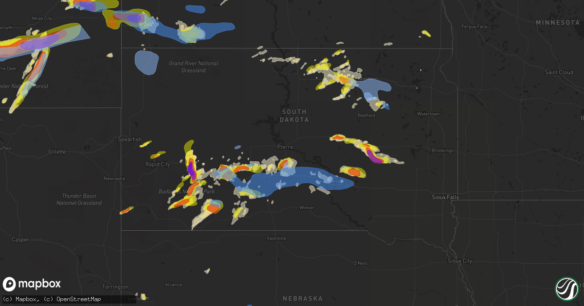
Hail Map in South Dakota on July 3, 2022
Get this storm
July 3 map
$229
one time, instant access
Download today. No call, no setup
Keep the $229
Bought the map and want the full workflow? Apply the entire $229 to a subscription within 7 days. None of it is wasted.
Every map, not just this one
This buys you this map. Subscription and you get every map we run, in the markets you choose from a few cities to whole states to nationwide. Plus real-time alerts the moment a storm fires.
Contact data
Name, contact info, occupancy, even credit band for addresses in the footprint. You go from where it hit to who to call.
Become the source they trust
Unlimited branding weather history reports on demand. You already have the documented answer ready for the property owner, and you are the one who showed up with it.
Property data and RoofTrace estimates
Pull up any address you have got, its value and the exact code rules for that jurisdiction, straight from One Click Code. Then RoofTrace estimates the squares, pitch, and roof value, priced the way you price.
Storm reports in South Dakota
South Dakota
| Date | Description |
|---|---|
| 07/03/20226:35 PM CDT | Mostly smaller... But some up to quarter sized. Also estimated wind gusts up to 50 mph. |
| 07/03/20226:08 PM CDT | Time estimated via radar |
| 07/03/20225:56 PM CDT | A local report indicates 2.00 inch wind near WASTA |
| 07/03/20225:53 PM CDT | A local report indicates 1.25 inch wind near 1 E STURGIS |
| 07/03/20225:52 PM CDT | A local report indicates 1.00 inch wind near 1 SSW STURGIS |
| 07/03/20225:50 PM CDT | A local report indicates 2.75 inch wind near 5 S WASTA |
| 07/03/20225:50 PM CDT | A local report indicates 1.00 inch wind near 1 SW STURGIS |
| 07/03/20225:45 PM CDT | A local report indicates 1.00 inch wind near 2 SSW PHILIP |
| 07/03/20225:45 PM CDT | A local report indicates 60 MPH wind near 2 SSW PHILIP |
| 07/03/20225:28 PM CDT | 30-40 mph winds with the hail |
| 07/03/20225:00 PM CDT | A local report indicates 1.00 inch wind near 6 NE SUMMERSET |
| 07/03/20224:48 PM CDT | A local report indicates 63 MPH wind near 10 W EDGEMONT |
| 07/03/20224:43 PM CDT | A local report indicates 65 MPH wind near 10 W EDGEMONT |
| 07/03/20224:38 PM CDT | A local report indicates 65 MPH wind near 10 W EDGEMONT |
| 07/03/20224:33 PM CDT | A local report indicates 59 MPH wind near 10 W EDGEMONT |
| 07/03/20224:30 PM CDT | A local report indicates 1.00 inch wind near SUMMERSET |
| 07/03/20224:17 PM CDT | Mesonet station 6 sd rwis forestburg. |
| 07/03/20224:06 PM CDT | A local report indicates 1.00 inch wind near 8 E ALPENA |
| 07/03/20223:58 PM CDT | Sanborn county sheriff reports damage to 7 power poles along hwy 34 - 6 are broken and the last is cracked. |
| 07/03/20222:58 PM CDT | Wind damage to a large portion of a mature tree. Radar estimated time. |
| 07/03/20222:54 PM CDT | A local report indicates 1.50 inch wind near 2 WSW WOLSEY |
| 07/03/202212:18 PM CDT | In addition to hail and strong winds... Heavy rain was also reported but not measured yet. |
| 07/03/202212:18 PM CDT | In addition to strong winds... Heavy rain was also reported but not measured yet. |
| 07/03/20227:02 AM CDT | At 1201 PM CDT, a severe thunderstorm was located 7 miles east of Gann Valley, or 17 miles north of Kimball, moving east at 30 mph. HAZARD...60 mph wind gusts and quarter size hail. SOURCE...Radar indicated. IMPACT...Hail damage to vehicles is expected. Expect wind damage to roofs, siding, and trees. Locations impacted include... Wessington Springs, Lane and Storla. |
| 07/03/20226:57 AM CDT | At 1157 PM CDT/1057 PM MDT/, a severe thunderstorm was located 10 miles north of 5 Mile Corner, or 11 miles northwest of Presho, moving east at 35 mph. HAZARD...60 mph wind gusts. SOURCE...Radar indicated. IMPACT...Expect damage to roofs, siding, and trees. This severe thunderstorm will be near... Fate Dam around 1210 AM CDT. Cedar Creek Rec Area around 1215 AM CDT.Other locations in the path of this severe thunderstorm include ByreLake and Joe Creek Rec Area. |
| 07/03/20226:39 AM CDT | At 1138 PM CDT, a severe thunderstorm was located near Mina, or 13 miles southeast of Ipswich, moving east at 25 mph. HAZARD...60 mph wind gusts and nickel size hail. SOURCE...Radar indicated. IMPACT...Expect damage to roofs, siding, and trees. This severe thunderstorm will remain over mainly rural areas of eastern Edmunds and southwestern Brown Counties. |
| 07/03/20226:35 AM CDT | At 1134 PM CDT, a severe thunderstorm was located near Cedar Butte, or 10 miles west of White River, moving east at 40 mph. HAZARD...60 mph wind gusts. SOURCE...Radar indicated. IMPACT...Expect damage to roofs, siding, and trees. Locations impacted include... Intersection of Highway 83 and White River. |
| 07/03/20226:06 AM CDT | At 1106 PM CDT/1006 PM MDT/, a severe thunderstorm was located near Capa, or 21 miles northwest of Murdo, moving east at 30 mph. HAZARD...60 mph wind gusts. SOURCE...Radar indicated. IMPACT...Expect damage to roofs, siding, and trees. This severe thunderstorm will be near... Capa around 1110 PM CDT.Other locations in the path of this severe thunderstorm include VanMetre. |
| 07/03/20225:59 AM CDT | At 1059 PM CDT, a severe thunderstorm was located near Ipswich, moving east at 30 mph. HAZARD...Half dollar size hail. SOURCE...Radar indicated. IMPACT...Damage to vehicles is expected. This severe thunderstorm will be near... Ipswich around 1105 PM CDT. Pembrook Colony around 1110 PM CDT.Other locations in the path of this severe thunderstorm includeCravens Corner, Mina and Mina Lake Rec Area. |
| 07/03/20225:27 AM CDT | At 1027 PM CDT, a severe thunderstorm was located near Cedar Creek Rec Area, or 15 miles northwest of Lower Brule, moving east at 25 mph. HAZARD...60 mph wind gusts. SOURCE...Radar indicated. IMPACT...Expect damage to roofs, siding, and trees. This severe thunderstorm will be near... Joe Creek Rec Area around 1035 PM CDT. West Bend Rec Area around 1045 PM CDT.Other locations in the path of this severe thunderstorm include LowerBrule. |
| 07/03/20225:27 AM CDT | At 1027 PM MDT/1127 PM CDT/, severe thunderstorms were located along a line extending from 6 miles south of Nowlin to 5 miles southeast of Belvidere to 2 miles northeast of Corn Creek, moving east at 40 mph. HAZARD...60 mph wind gusts and penny size hail. SOURCE...Radar indicated. IMPACT...Expect damage to roofs, siding, and trees. Severe thunderstorms will be near... Cedar Butte around 1140 PM CDT. Midland around 1045 PM MDT.Other locations in the path of these severe thunderstorms includeSwift Bear and White River.This includes Interstate 90 in South Dakota between Mile Markers 158and 174. |
| 07/03/20224:42 AM CDT | At 942 PM CDT, a severe thunderstorm was located 13 miles southwest of Rousseau, or 15 miles south of Pierre, moving east at 30 mph. HAZARD...60 mph wind gusts. SOURCE...Radar indicated. IMPACT...Expect damage to roofs, siding, and trees. Locations impacted include... Cedar Creek Rec Area, Degrey Rec Area and Joe Creek Rec Area. |
| 07/03/20224:21 AM CDT | At 921 PM MDT, severe thunderstorms were located along a line extending from 2 miles north of Potato Creek to 5 miles northeast of Yellow Bear Canyon to 2 miles south of Wakpamni, moving east at 30 mph. HAZARD...70 mph wind gusts. SOURCE...Radar indicated. IMPACT...Expect considerable tree damage. Damage is likely to mobile homes, roofs, and outbuildings. Severe thunderstorms will be near... Potato Creek, Allen and Snake Butte around 925 PM MDT.Other locations in the path of these severe thunderstorms includeHisle, Eagle Nest Butte, Wanblee, Martin, Long Valley, George Town,Lacreek Wildlife Refuge, Sunrise Housing and Tuthill. |
| 07/03/20224:15 AM CDT | At 915 PM MDT, severe thunderstorms were located along a line extending from 4 miles southeast of Grindstone to 3 miles southwest of Philip to 9 miles east of Cactus Flat, moving northeast at 30 mph. HAZARD...60 mph wind gusts. SOURCE...Radar indicated. IMPACT...Expect damage to roofs, siding, and trees. Severe thunderstorms will be near... Philip around 920 PM MDT. Kadoka and Grindstone Butte around 935 PM MDT.Other locations in the path of these severe thunderstorms includeOttumwa, Nowlin and Midland.This includes Interstate 90 in South Dakota between Mile Markers 134and 156. |
| 07/03/20224:15 AM CDT | At 915 PM CDT, a severe thunderstorm was located near Hillsview, or 10 miles southeast of Eureka, moving northeast at 10 mph. HAZARD...Ping pong ball size hail and 60 mph wind gusts. SOURCE...Radar indicated. IMPACT...People and animals outdoors will be injured. Expect hail damage to roofs, siding, windows, and vehicles. Expect wind damage to roofs, siding, and trees. Locations impacted include... New Town Corner. |
| 07/03/20222:14 AM CDT | At 713 PM CDT/613 PM MDT/, a severe thunderstorm was located near Midland, or 22 miles northwest of Murdo, moving east at 30 mph. HAZARD...Two inch hail and 60 mph wind gusts. SOURCE...Radar indicated. IMPACT...People and animals outdoors will be injured. Expect hail damage to roofs, siding, windows, and vehicles. Expect wind damage to roofs, siding, and trees. This severe thunderstorm will be near... Capa around 730 PM CDT.Other locations in the path of this severe thunderstorm include VanMetre. |
| 07/03/20222:03 AM CDT | At 702 PM CDT, a severe thunderstorm was located near Pembrook Colony, or 11 miles south of Ipswich, moving northeast at 20 mph. HAZARD...60 mph wind gusts and quarter size hail. SOURCE...Radar indicated. IMPACT...Hail damage to vehicles is expected. Expect wind damage to roofs, siding, and trees. This severe thunderstorm will be near... Pembrook Colony around 710 PM CDT. |
| 07/03/20221:26 AM CDT | Grain leg at the local grain elevator tipped over. Estimated time base of radar data. |
| 07/03/202212:46 AM CDT | Mesonet station 285 14w lower brule |
| 07/03/202212:46 AM CDT | At 546 AM CDT, a severe thunderstorm was located near Virgil, or 7 miles southwest of Huron, moving southeast at 35 mph. HAZARD...60 mph wind gusts and half dollar size hail. SOURCE...Radar indicated. IMPACT...Hail damage to vehicles is expected. Expect wind damage to roofs, siding, and trees. This severe thunderstorm will be near... Huron around 550 AM CDT. Cavour around 605 AM CDT. |
| 07/03/202212:39 AM CDT | At 539 PM MDT, a severe thunderstorm was located 6 miles southwest of Nowlin, or 11 miles northeast of Kadoka, moving east at 20 mph. HAZARD...Golf ball size hail and 60 mph wind gusts. SOURCE...Radar indicated. IMPACT...People and animals outdoors will be injured. Expect hail damage to roofs, siding, windows, and vehicles. Expect wind damage to roofs, siding, and trees. This severe thunderstorm will be near... Nowlin around 555 PM MDT.Other locations in the path of this severe thunderstorm includeMidland.This includes Interstate 90 in South Dakota between Mile Markers 172and 174. |
| 07/03/202212:37 AM CDT | At 537 AM CDT, a severe thunderstorm was located 7 miles south of Bryant, or 11 miles north of Lake Thompson State Recreation Area, moving east at 30 mph. HAZARD...Quarter size hail. SOURCE...Radar indicated. IMPACT...Damage to vehicles is expected. This severe thunderstorm will be near... Badger around 605 AM CDT.Other locations impacted by this severe thunderstorm include Erwin. |
| 07/03/202212:24 AM CDT | At 524 PM MDT, a severe thunderstorm was located 3 miles west of Rockyford, or 30 miles north of Pine Ridge, moving east at 25 mph. HAZARD...Ping pong ball size hail and 60 mph wind gusts. SOURCE...Radar indicated. IMPACT...People and animals outdoors will be injured. Expect hail damage to roofs, siding, windows, and vehicles. Expect wind damage to roofs, siding, and trees. This severe thunderstorm will be near... Rockyford around 535 PM MDT. Thunder Valley around 540 PM MDT.Other locations in the path of this severe thunderstorm include Kyleand Kyle North Route Housing. |
| 07/03/202212:21 AM CDT | At 521 PM MDT, a severe thunderstorm was located 6 miles south of Elm Springs, or 39 miles east of Rapid City, moving north at 20 mph. HAZARD...60 mph wind gusts and half dollar size hail. SOURCE...Radar indicated. IMPACT...Hail damage to vehicles is expected. Expect wind damage to roofs, siding, and trees. This severe thunderstorm will be near... Elm Springs around 540 PM MDT. |
| 07/03/202212:16 AM CDT | Mesonet station 175 mellette |
| 07/03/202212:14 AM CDT | Fort pierre raws. |
| 07/03/202212:10 AM CDT | Asos station kabr aberdeen rgnl ap. |
| 07/03/202212:10 AM CDT | Corrects previous tstm wnd gst report from aberdeen regional airport to add that a mature tree was pushed over near 10th avenue and park street in aberdeen. |
| 07/03/202212:08 AM CDT | A local report indicates 61 MPH wind near 1 N BUFFALO |
| 07/03/202212:02 AM CDT | At 501 AM MDT, a severe thunderstorm was located near Hayes, or 31 miles west of Fort Pierre, moving northeast at 20 mph. HAZARD...60 mph wind gusts and quarter size hail. SOURCE...Radar indicated. IMPACT...Hail damage to vehicles is expected. Expect wind damage to roofs, siding, and trees. This severe thunderstorm will be near... Hayes around 505 AM MDT. |
| 07/02/202211:49 PM CDT | A local report indicates 60 MPH wind near 6 NNW MANSFIELD |
| 07/02/202211:48 PM CDT | At 448 PM MDT, a severe thunderstorm was located over Fort Meade, or over Sturgis, moving east at 10 mph. HAZARD...Quarter size hail. SOURCE...Radar indicated. IMPACT...Damage to vehicles is expected. Locations impacted include... Sturgis, Fort Meade and Bear Butte State Park. This includes Interstate 90 in South Dakota between Mile Markers 29and 35. |
| 07/02/202211:42 PM CDT | Mesonet station 13 vivian |
| 07/02/202211:41 PM CDT | At 441 PM CDT, a severe thunderstorm was located over Carthage, or 18 miles southwest of Lake Thompson State Recreation Area, moving east at 25 mph. HAZARD...70 mph wind gusts and quarter size hail. SOURCE...Radar indicated. IMPACT...Hail damage to vehicles is expected. Expect considerable tree damage. Wind damage is also likely to mobile homes, roofs, and outbuildings. This severe thunderstorm will be near... Vilas around 455 PM CDT.Other locations in the path of this severe thunderstorm includeHoward, Winfred and Oldham. |
| 07/02/202211:41 PM CDT | At 440 PM MDT, a severe thunderstorm was located over Philip, moving east at 10 mph. HAZARD...Golf ball size hail and 60 mph wind gusts. SOURCE...Radar indicated. IMPACT...People and animals outdoors will be injured. Expect hail damage to roofs, siding, windows, and vehicles. Expect wind damage to roofs, siding, and trees. This severe thunderstorm will remain over mainly rural areas of south central Haakon and north central Jackson Counties. |
| 07/02/202211:29 PM CDT | At 428 PM MDT, a severe thunderstorm was located 8 miles southeast of Owanka, or 39 miles east of Rapid City, moving north at 15 mph. THIS IS A DESTRUCTIVE STORM FOR WASTA AND WICKSVILLE. HAZARD...Baseball size hail and 60 mph wind gusts. SOURCE...Radar indicated. IMPACT...People and animals outdoors will be severely injured. Expect shattered windows, extensive damage to roofs, siding, and vehicles. Locations impacted include... Owanka, Wasta and Wicksville.This includes Interstate 90 in South Dakota between Mile Markers 87and 106. |
| 07/02/202211:20 PM CDT | Mesonet station 173 craven |
| 07/02/202211:19 PM CDT | Telephone call report. |
| 07/02/202211:00 PM CDT | At 400 PM CDT, a severe thunderstorm was located near Alpena, or 14 miles south of Huron, moving east at 35 mph. HAZARD...Tennis ball size hail and 70 mph wind gusts. SOURCE...Radar indicated. IMPACT...People and animals outdoors will be injured. Expect hail damage to roofs, siding, windows, and vehicles. Expect considerable tree damage. Wind damage is also likely to mobile homes, roofs, and outbuildings. This severe thunderstorm will be near... Forestburg around 420 PM CDT.Other locations in the path of this severe thunderstorm includeArtesian, Carthage, Fedora and Roswell. |
| 07/02/202211:00 PM CDT | At 400 PM MDT, severe thunderstorms were located along a line extending from Badlands National Park to 6 miles northwest of Rockyford, moving northeast at 20 mph. HAZARD...60 mph wind gusts and half dollar size hail. SOURCE...Radar indicated. IMPACT...Hail damage to vehicles is expected. Expect wind damage to roofs, siding, and trees. Severe thunderstorms will be near... Scenic around 405 PM MDT. Sheep Mountain Table around 420 PM MDT.Other locations in the path of these severe thunderstorms includeBadlands National Park, Pinnacles Ranger Station, Wall, Quinn andDelta 9 Missile Silo.This includes Interstate 90 in South Dakota between Mile Markers 86and 128. |
| 07/02/202210:49 PM CDT | At 349 PM MDT, a severe thunderstorm was located 4 miles east of Cottonwood, or 8 miles southwest of Philip, moving east at 15 mph. HAZARD...Ping pong ball size hail and 60 mph wind gusts. SOURCE...Radar indicated. IMPACT...People and animals outdoors will be injured. Expect hail damage to roofs, siding, windows, and vehicles. Expect wind damage to roofs, siding, and trees. Locations impacted include... Philip. |
| 07/02/202210:47 PM CDT | At 346 PM MDT, a severe thunderstorm was located 4 miles northeast of Summerset, or 10 miles north of Rapid City, moving east at 15 mph. HAZARD...60 mph wind gusts and half dollar size hail. SOURCE...Radar indicated. IMPACT...Hail damage to vehicles is expected. Expect wind damage to roofs, siding, and trees. This severe thunderstorm will be near... Ellsworth Air Force Base around 405 PM MDT.This includes Interstate 90 in South Dakota between Mile Markers 43and 53. |
| 07/02/202210:41 PM CDT | At 341 PM MDT, a severe thunderstorm was located 6 miles west of Edgemont, moving east at 20 mph. HAZARD...Ping pong ball size hail and 60 mph wind gusts. SOURCE...Radar indicated. IMPACT...People and animals outdoors will be injured. Expect hail damage to roofs, siding, windows, and vehicles. Expect wind damage to roofs, siding, and trees. This severe thunderstorm will be near... Edgemont around 400 PM MDT.Other locations in the path of this severe thunderstorm includeCascade Falls and Cottonwood Springs Dam. |
| 07/02/202210:28 PM CDT | At 327 PM CDT, a severe thunderstorm was located near St. Lawrence, or near Miller, moving east at 25 mph. HAZARD...60 mph wind gusts and half dollar size hail. SOURCE...Radar indicated. IMPACT...Hail damage to vehicles is expected. Expect wind damage to roofs, siding, and trees. This severe thunderstorm will be near... Vayland around 340 PM CDT. |
| 07/02/202210:23 PM CDT | At 323 PM CDT, a severe thunderstorm was located near Virgil, or 14 miles west of Huron, moving east at 30 mph. HAZARD...60 mph wind gusts and half dollar size hail. SOURCE...Radar indicated. IMPACT...Hail damage to vehicles is expected. Expect wind damage to roofs, siding, and trees. This severe thunderstorm will be near... Virgil around 335 PM CDT.Other locations in the path of this severe thunderstorm includeAlpena, Huron and Woonsocket. |
| 07/02/202210:05 PM CDT | Mesonet station 185 blunt |
| 07/02/202210:05 PM CDT | A local report indicates 63 MPH wind near 2 E COTTONWOOD |
| 07/02/202210:03 PM CDT | At 303 PM MDT, a severe thunderstorm was located over Lonesome Valley, or 27 miles north of Pine Ridge, moving east at 20 mph. HAZARD...Ping pong ball size hail and 60 mph wind gusts. SOURCE...Radar indicated. IMPACT...People and animals outdoors will be injured. Expect hail damage to roofs, siding, windows, and vehicles. Expect wind damage to roofs, siding, and trees. This severe thunderstorm will be near... Thunder Valley and Sharps Corner around 320 PM MDT.Other locations in the path of this severe thunderstorm include KyleNorth Route Housing and Kyle. |
| 07/02/20229:54 PM CDT | At 254 PM CDT, a severe thunderstorm was located over Wolsey, or 14 miles west of Huron, moving northeast at 25 mph. HAZARD...60 mph wind gusts and quarter size hail. SOURCE...Radar indicated. IMPACT...Hail damage to vehicles is expected. Expect wind damage to roofs, siding, and trees. This severe thunderstorm will be near... Wolsey around 300 PM CDT.Other locations in the path of this severe thunderstorm includeHuron. |
| 07/02/20229:49 PM CDT | At 249 PM CDT, a severe thunderstorm was located over Ree Heights, or 10 miles east of Highmore, moving east at 25 mph. HAZARD...60 mph wind gusts and half dollar size hail. SOURCE...Radar indicated. IMPACT...Hail damage to vehicles is expected. Expect wind damage to roofs, siding, and trees. Locations impacted include... Miller and St. Lawrence. |
| 07/02/20229:42 PM CDT | Mesonet station 13 vivian |
| 07/02/20229:28 PM CDT | At 227 AM CDT, a severe thunderstorm was located near Oacoma, or near Chamberlain, moving east at 35 mph. HAZARD...60 mph wind gusts and penny size hail. SOURCE...Radar indicated. IMPACT...Expect damage to roofs, siding, and trees. This severe thunderstorm will remain over mainly rural areas of northern Brule County, including the following locations... Pukwana. |
| 07/02/20229:25 PM CDT | A local report indicates 60 MPH wind near 1 NE MIDLAND |
| 07/02/20229:13 PM CDT | A local report indicates 1.25 inch wind near LEOLA |
| 07/02/20228:39 PM CDT | At 138 AM CDT, a severe thunderstorm was located near Earling Hill, or 7 miles southeast of Presho, moving east at 30 mph. HAZARD...60 mph wind gusts and penny size hail. SOURCE...Radar indicated. IMPACT...Expect damage to roofs, siding, and trees. This severe thunderstorm will be near... Kennebec and Byre Lake around 150 AM CDT.Other locations in the path of this severe thunderstorm includeLyman, Reliance and Medicine Butte. |
| 07/02/20228:12 PM CDT | A local report indicates 59 MPH wind near 10 NNW OTTUMWA |
| 07/02/20228:04 PM CDT | At 104 AM CDT/1204 AM MDT/, a severe thunderstorm was located near Pierre, moving east at 40 mph. HAZARD...60 mph wind gusts. SOURCE...Radar indicated. IMPACT...Expect damage to roofs, siding, and trees. This severe thunderstorm will be near... Rousseau around 115 AM CDT. Canning around 120 AM CDT.Other locations in the path of this severe thunderstorm includeDegrey Rec Area and Harrold. |
| 07/02/20227:19 PM CDT | 50 to 60 mph wind gusts. Radar-estimated time. |
All States Impacted by Hail Map on July 3, 2022
Cities Impacted by Hail Map on July 3, 2022
- Brewster, WA
- Quincy, WA
- Malaga, WA
- Rock Island, WA
- Philipsburg, MT
- Cohagen, MT
- Orofino, ID
- Mound City, SD
- Ismay, MT
- Regent, ND
- Mott, ND
- New England, ND
- Hettinger, ND
- Fallon, MT
- Glendive, MT
- Terry, MT
- Max, ND
- Douglas, ND
- Wakpala, SD
- McLaughlin, SD
- Pollock, SD
- Herreid, SD
- Colfax, WA
- Ekalaka, MT
- Interior, SD
- Elgin, ND
- Glen Ullin, ND
- Almont, ND
- Plains, MT
- Wyndmere, ND
- Lidgerwood, ND
- Velva, ND
- Wibaux, MT
- Aberdeen, SD
- Westport, SD
- Lindsay, MT
- Bloomfield, MT
- Deer Park, WA
- Nine Mile Falls, WA
- Leola, SD
- Decker, MT
- Spencer, ID
- Lima, MT
- Dubois, ID
- Cameron, MT
- Bowdle, SD
- Darby, MT
- Volborg, MT
- Pray, MT
- Gardiner, MT
- Livingston, MT
- Huntley, MT
- Sheridan, WY
- Birney, MT
- Hardin, MT
- Worden, MT
- Ballantine, MT
- Colstrip, MT
- Pompeys Pillar, MT
- Bighorn, MT
- Otter, MT
- Forsyth, MT
- Thornton, WA
- Oakesdale, WA
- Jordan, MT
- Midland, SD
- Cresbard, SD
- Long Valley, SD
- Belvidere, SD
- Rhame, ND
- Bowman, ND
- Underwood, MN
- Battle Lake, MN
- Washburn, ND
- Selfridge, ND
- Northville, SD
- Sand Springs, MT
- Brockway, MT
- Brusett, MT
- Winnett, MT
- Mosby, MT
- Underwood, ND
- Kadoka, SD
- Amidon, ND
- Webster, SD
- Pomaria, SC
- White River, SD
- Pine Ridge, SD
- Conner, MT
- Sula, MT
- Rosebud, MT
- Eureka, SD
- Java, SD
- Hot Springs, MT
- Lonepine, MT
- Ludlow, SD
- Billings, MT
- Shepherd, MT
- Acton, MT
- Colville, WA
- Long Lake, SD
- Chamberlain, SD
- Hamill, SD
- Gregory, SD
- Graettinger, IA
- Bridgeport, TX
- Wilmington, NC
- Philip, SD
- Wall, SD
- Pukwana, SD
- Model, CO
- Jacksboro, TX
- Bowie, TX
- Ward, CO
- Jamestown, CO
- Windthorst, TX
- Scotland, TX
- Henrietta, TX
- Dodd City, TX
- Windom, TX
- Honey Grove, TX
- Forestburg, TX
- Alvord, TX
- Jerico Springs, MO
- New Underwood, SD
- Bishopville, SC
- Hartsville, SC
- McBee, SC
- Saint Jo, TX
- Muenster, TX
- Chico, TX
- Ryan, OK
- Ringling, OK
- Nocona, TX
- Marietta, OK
- Fort Scott, KS
- Bertrand, NE
- Waldo, KS
- Paradise, KS
- Russell, KS
- Arcadia, NE
- Ipswich, SD
- New Bern, NC
- Cave Springs, AR
- Springdale, AR
- Lowell, AR
- Rogers, AR
- Bentonville, AR
- Early Branch, SC
- Throckmorton, TX
- Seymour, TX
- Willard, MO
- Le Roy, KS
- Roscoe, SD
- Hosmer, SD
- Yemassee, SC
- Colony, KS
- Tolstoy, SD
- Ree Heights, SD
- Highmore, SD
- Miller, SD
- Campbell, NE
- Bladen, NE
- Murdo, SD
- Clarkton, NC
- Bladenboro, NC
- Norris, SD
- Martin, SD
- Wichita Falls, TX
- Wolsey, SD
- Big Timber, MT
- Ryegate, MT
- Melville, MT
- Rapelje, MT
- Reed Point, MT
- Draper, SD
- Porcupine, SD
- Wounded Knee, SD
- Wanblee, SD
- Batesland, SD
- Allen, SD
- Kyle, SD
- Wasta, SD
- Scenic, SD
- Owanka, SD
- Goodland, KS
- Pilot Point, TX
- Tioga, TX
- Alpena, SD
- Woonsocket, SD
- Neodesha, KS
- Altoona, KS
- Buffalo, KS
- Benedict, KS
- Fredonia, KS
- Glenvil, NE
- Hastings, NE
- Inland, NE
- Ayr, NE
- Curtis, NE
- Moorefield, NE
- Okaton, SD
- Cleo Springs, OK
- Nevada, MO
- Arcadia, KS
- Elizabethtown, NC
- Greensboro, GA
- Union Point, GA
- Bryson, TX
- Lindsay, NE
- Bellevue, TX
- Gainesville, TX
- Tuthill, SD
- Mcdonough, GA
- Concord, GA
- Molena, GA
- Huron, SD
- Oacoma, SD
- Yates Center, KS
- Carthage, SD
- Artesian, SD
- Sturgis, SD
- Fort Meade, SD
- Kennebec, SD
- Fort Myers, FL
- Lakemont, GA
- Tiger, GA
- Troy, NC
- Lewellen, NE
- Chappell, NE
- Oshkosh, NE
- Big Springs, NE
- Graniteville, SC
- Auburntown, TN
- Liberty, TN
- Alexandria, TN
- Ruby, SC
- Chesterfield, SC
- Nashville, TN
- Randlett, OK
- Delco, NC
- Westphalia, KS
- Burlington, KS
- Waverly, KS
- Fergus Falls, MN
- Dalton, MN
- Loving, TX
- Neosho Falls, KS
- Electra, TX
- Broadview, MT
- Rapid City, SD
- Piedmont, SD
- Farnam, NE
- Stockville, NE
- Maywood, NE
- Wellfleet, NE
- Hayes Center, NE
- Ridgeway, SC
- Ottawa, KS
- Dalzell, SC
- Rembert, SC
- Graysville, TN
- Presho, SD
- Vivian, SD
- Richmond, KS
- Garnett, KS
- Durant, OK
- Faulkton, SD
- Leland, NC
- Kimball, SD
- White Lake, SD
- Wessington Springs, SD
- Scottsbluff, NE
- Gann Valley, SD
- Plankinton, SD
- Cove City, NC
- Pomona, KS
- Watkinsville, GA
- Bishop, GA
- Millen, GA
- Dulce, NM
- Magnolia, NC
- Warsaw, NC
- Hookerton, NC
- Grifton, NC
- Minatare, NE
- Holliday, TX
- Elizabeth City, NC
- Roseland, NE
- Eden, SD
- Opelika, AL
- Redfield, SD
- Brentford, SD
- Ashton, SD
- Conde, SD
- Doland, SD
- Turton, SD
- Frankfort, SD
- Mellette, SD
- Sanger, TX
- Monroe, NC
- Pageland, SC
- Molt, MT
- Dalton, NE
- Lisco, NE
- Wood, SD
- Lumberton, NC
- Oak Ridge, TN
- Valley View, TX
- Sherman, TX
- Missouri Valley, IA
- Logan, IA
- Kinston, NC
- Manderson, SD
- Piqua, KS
- Evergreen, NC
- Chadbourn, NC
- Upland, NE
- Minden, NE
- Franklin, NE
- Bloomington, NE
- Hildreth, NE
- Harvard, NE
- Athens, GA
- South Mills, NC
- Virgil, SD
- Wessington, SD
- Oakes, ND
- Cogswell, ND
- Reliance, SD
- Lower Brule, SD
- Fayetteville, NC
- White Oak, NC
- Hiawassee, GA
- Ellsworth, NE
- Bingham, NE
- Riverton, NE
- Galivants Ferry, SC
- Marion, SC
- Gresham, SC
- Blossom, TX
- Jefferson, SC
- Ringgold, TX
- Millry, AL
- Saint Lawrence, SD
- Loco, OK
- Deadwood, SD
- Clarks Hill, SC
- Caputa, SD
- Fort Pierre, SD
- Quinn, SD
- Fedora, SD
- Iroquois, SD
- Cavour, SD
- Albion, NE
- Comstock, NE
- Westerville, NE
- Ansley, NE
- Rosston, TX
- Blair, SC
- Paradise, TX
- Rutledge, GA
- Madison, GA
- Lamar, SC
- Lance Creek, WY
- Kershaw, SC
- Ringgold, GA
- Mitchell, NE
- Edgemont, SD
- Columbus, KS
- Scammon, KS
- Fruitdale, AL
- Vinegar Bend, AL
- Monroe, GA
- Good Hope, GA
- Milo, MO
- Conyers, GA
- Onaka, SD
- Hooper, NE
- Mullins, SC
- Wrightsville Beach, NC
- Ashley, ND
- Cayuga, ND
- Rockham, SD
- Dewy Rose, GA
- Saint Pauls, NC
- Poolville, TX
- Fayetteville, AR
- Naponee, NE
- Bogart, GA
- Statham, GA
- Omaha, NE
- Addy, WA
- Strandquist, MN
- Newfolden, MN
- New Leipzig, ND
- Pendleton, OR
- Estelline, SD
- Henning, MN
- Brule, NE
- Plevna, MT
- Baker, MT
- Willard, MT
- Milesville, SD
- Groton, SD
- Warner, SD
- Andover, SD
- Mansfield, SD
- Stratford, SD
- Bath, SD
- Ferney, SD
- Reva, SD
- Buffalo, SD
- Raymond, SD
- Grand Island, NE
- Polson, MT
- Custer, MT
- Marmarth, ND
- Mullen, NE
- Sutherland, NE
- Arthur, NE
- Tryon, NE
- Lemoyne, NE
- Doniphan, NE
- Chapman, NE
- Phillips, NE
- Alda, NE
- Black Hawk, SD
- Enning, SD
- Howes, SD
- Carson, ND
- Scranton, ND
- Reeder, ND
- Dickinson, ND


