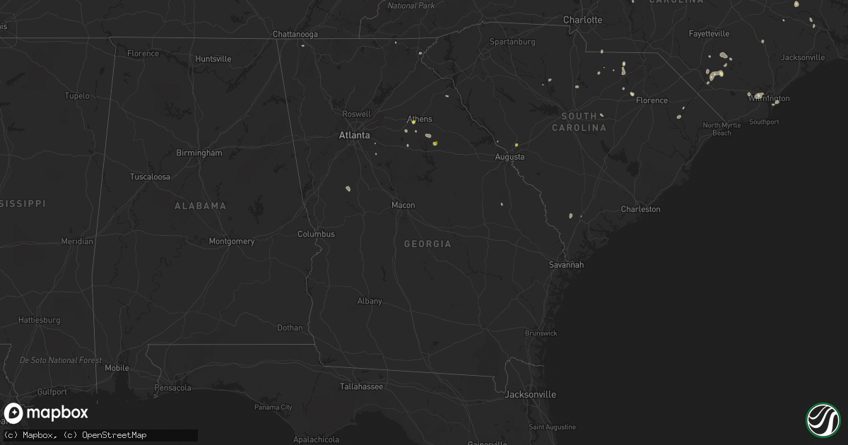
Hail Map in Georgia on July 3, 2022
Get this storm
July 3 map
$229
one time, instant access
Download today. No call, no setup
Keep the $229
Bought the map and want the full workflow? Apply the entire $229 to a subscription within 7 days. None of it is wasted.
Every map, not just this one
This buys you this map. Subscription and you get every map we run, in the markets you choose from a few cities to whole states to nationwide. Plus real-time alerts the moment a storm fires.
Contact data
Name, contact info, occupancy, even credit band for addresses in the footprint. You go from where it hit to who to call.
Become the source they trust
Unlimited branding weather history reports on demand. You already have the documented answer ready for the property owner, and you are the one who showed up with it.
Property data and RoofTrace estimates
Pull up any address you have got, its value and the exact code rules for that jurisdiction, straight from One Click Code. Then RoofTrace estimates the squares, pitch, and roof value, priced the way you price.
Storm reports in Georgia
Georgia
| Date | Description |
|---|---|
| 07/03/20226:04 PM CDT | Tree down at konahetah dr and konahetah rd |
| 07/03/20226:04 PM CDT | Tree and powerlines down s dogwood road and pine st |
| 07/03/20225:59 PM CDT | Two trees down at massedonia rd near watson springs rd and price rd |
| 07/03/20225:40 PM CDT | Tree and power lines on road at jacks creek rd and old good hope rd |
| 07/03/20225:35 PM CDT | Tree down on hwy 78 at pete dickens rd |
| 07/03/20225:12 PM CDT | 1 large oak tree down on anna dr north of annas walk. |
| 07/03/20225:07 PM CDT | Ping pong sized hail reported by caller in athens... Ga. |
| 07/03/20225:03 PM CDT | Tree down on beaverdam road at beaver trail |
| 07/03/20224:30 PM CDT | Tree down at revel cove dr and lancaster creek cir |
| 07/03/20224:26 PM CDT | Tree down at meadowbrook dr and meadowbrook cir |
| 07/03/20224:21 PM CDT | Powerlines down at fall line fwy and deepstep rd |
| 07/03/20224:21 PM CDT | Tree down at east mccarty st and n hospital rd |
| 07/03/20222:12 PM CDT | Power line down on pricemill rd near paxson dairy rd |
| 07/03/20222:07 PM CDT | Tree down at dixie highway and wilson rd. |
| 07/03/20221:58 PM CDT | Tree down at 400 block of cotter rd |
| 07/03/20221:58 PM CDT | Tree down at poplar springs and oak st and tree down at baggett rd and john drive |
| 07/03/20221:30 PM CDT | Tree down at park stree and indiana street |
| 07/03/20221:29 PM CDT | Tree down 900 block cherokee trail near rossville |
| 07/03/20222:20 AM CDT | At 720 PM EDT, a severe thunderstorm was located over Adrian, or 10 miles north of Soperton, and is nearly stationary. HAZARD...60 mph wind gusts and quarter size hail. SOURCE...Radar indicated. IMPACT...Hail damage to vehicles is expected. Expect wind damage to roofs, siding, and trees. Locations impacted include... Adrian, Norristown Junction, Covena, Meeks, Orland, Orianna, Blackville, Norristown, Gillis Springs and Scott. |
| 07/03/20221:46 AM CDT | At 646 PM EDT, a severe thunderstorm was located over Union Point, or near Greensboro, and is nearly stationary. HAZARD...60 mph wind gusts and quarter size hail. SOURCE...Radar indicated. IMPACT...Hail damage to vehicles is expected. Expect wind damage to roofs, siding, and trees. Locations impacted include... Greensboro, Crawfordville, Union Point, Woodville, White Plains, Siloam, Maxeys, Stephens, Veazey, Robinson, Daniel Springs, Penfield, Lyneville and Alexander Stephens Park. |
| 07/03/20221:32 AM CDT | At 632 PM EDT, a severe thunderstorm was located near Bostwick, or 9 miles southwest of Watkinsville, and is nearly stationary. HAZARD...60 mph wind gusts and quarter size hail. SOURCE...Radar indicated. IMPACT...Hail damage to vehicles is expected. Expect wind damage to roofs, siding, and trees. Locations impacted include... Monroe, North High Shoals, Bostwick, Good Hope, Bishop, Ebenezer, Gratis, Eastville, Farmington, Apalachee, Campton and Hard Labor Creek State Park. |
| 07/03/20221:01 AM CDT | At 601 PM EDT, a severe thunderstorm was located over Madison, and is nearly stationary. HAZARD...60 mph wind gusts and quarter size hail. SOURCE...Radar indicated. IMPACT...Hail damage to vehicles is expected. Expect wind damage to roofs, siding, and trees. Locations impacted include... Madison, Buckhead, Godfrey, Parks Mill and Swords. |
| 07/03/202212:55 AM CDT | At 554 PM EDT, a severe thunderstorm was located over Swainsboro, and is nearly stationary. HAZARD...60 mph wind gusts and quarter size hail. SOURCE...Radar indicated. IMPACT...Hail damage to vehicles is expected. Expect wind damage to roofs, siding, and trees. Locations impacted include... Swainsboro, Kite, Norristown Junction, Dellwood, Covena, Modoc and Norristown. |
| 07/03/202212:45 AM CDT | At 544 PM EDT, a severe thunderstorm was located over Bogart, or 7 miles northwest of Watkinsville, and is nearly stationary. HAZARD...60 mph wind gusts and quarter size hail. SOURCE...Radar indicated. IMPACT...Hail damage to vehicles is expected. Expect wind damage to roofs, siding, and trees. Locations impacted include... Watkinsville, Statham, Bogart, North High Shoals, Bostwick, Bishop, Athens-Clarke County, Whitehall, Westgate Park, Beechwood Hills, Oconee Heights, Eastville, Barnett Shoals, State Botanical Garden Of Ga, Farmington and Bear Creek Reservoir. |
| 07/03/202212:41 AM CDT | At 540 PM EDT, a severe thunderstorm was located near Molena, or 9 miles west of Zebulon, and is nearly stationary. HAZARD...60 mph wind gusts and quarter size hail. SOURCE...Radar indicated. IMPACT...Hail damage to vehicles is expected. Expect wind damage to roofs, siding, and trees. Locations impacted include... Zebulon, Woodbury, Molena, Meansville, Gay, Hilltop, Lifsey Springs, Imlac and Hollonville. |
| 07/03/202212:37 AM CDT | At 537 PM EDT, a severe thunderstorm was located over Jenkinsburg, or near Jackson, and is nearly stationary. HAZARD...60 mph wind gusts and quarter size hail. SOURCE...Radar indicated. IMPACT...Hail damage to vehicles is expected. Expect wind damage to roofs, siding, and trees. Locations impacted include... Jackson, Locust Grove, Flovilla, Jenkinsburg, Ola, Worthville, McKibben, Indian Springs State Park and Stark. |
| 07/03/202212:33 AM CDT | At 533 PM EDT, a severe thunderstorm was located over Oak Hill, or 8 miles northeast of McDonough, and is nearly stationary. HAZARD...60 mph wind gusts and quarter size hail. SOURCE...Radar indicated. IMPACT...Hail damage to vehicles is expected. Expect wind damage to roofs, siding, and trees. Locations impacted include... Covington, Porterdale, Fincherville, Oak Hill and Rocky Plains. |
| 07/03/202212:28 AM CDT | At 527 PM EDT, a severe thunderstorm was located over Arabia Mountain, or near Conyers, and is nearly stationary. HAZARD...60 mph wind gusts and quarter size hail. SOURCE...Radar indicated. IMPACT...Hail damage to vehicles is expected. Expect wind damage to roofs, siding, and trees. Locations impacted include... Conyers, Lithonia, Lakeview Estates, Georgia International Horse Park, Magnet, Milstead, Richardson Park, Arabia Mountain and Redan. |
| 07/03/202212:17 AM CDT | At 517 PM EDT, a severe thunderstorm was located over Sandersville, and is nearly stationary. HAZARD...60 mph wind gusts and quarter size hail. SOURCE...Radar indicated. IMPACT...Hail damage to vehicles is expected. Expect wind damage to roofs, siding, and trees. Locations impacted include... Sandersville, Davisboro, Tennille, Oconee and Riddleville. |
| 07/03/202212:14 AM CDT | At 514 PM EDT, a severe thunderstorm was located over Payne, or over Macon, and is nearly stationary. HAZARD...60 mph wind gusts and quarter size hail. SOURCE...Radar indicated. IMPACT...Hail damage to vehicles is expected. Expect wind damage to roofs, siding, and trees. Locations impacted include... Macon, Payne, Payne City, Cross Keys, Wesleyan and Arkwright. |
| 07/03/202212:08 AM CDT | At 508 PM EDT, a severe thunderstorm was located over Hilltop, or near Zebulon, and is nearly stationary. HAZARD...60 mph wind gusts and quarter size hail. SOURCE...Radar indicated. IMPACT...Hail damage to vehicles is expected. Expect wind damage to roofs, siding, and trees. Locations impacted include... Zebulon, Meansville, Lifsey Springs and Hilltop. |
| 07/03/202212:05 AM CDT | At 505 PM EDT, a severe thunderstorm was located over Huber, or 7 miles southeast of Macon, and is nearly stationary. HAZARD...60 mph wind gusts and quarter size hail. SOURCE...Radar indicated. IMPACT...Hail damage to vehicles is expected. Expect wind damage to roofs, siding, and trees. Locations impacted include... Macon, Warner Robins, Robins Air Force Base, Marion, Rutland, Fitzpatrick, Ripley, Huber, Dry Branch, Elberta, Franklinton, Middle Georgia Regional Airport and Bullard. |
| 07/03/202212:03 AM CDT | At 502 PM EDT, a severe thunderstorm was located over Snapfinger, or 9 miles southeast of Decatur, and is nearly stationary. HAZARD...60 mph wind gusts and quarter size hail. SOURCE...Radar indicated. IMPACT...Hail damage to vehicles is expected. Expect wind damage to roofs, siding, and trees. Locations impacted include... Lithonia, Belvedere Park, Candler-Mcafee, Hidden Valley Park, Panola Mountain State Park, Belmont, Richardson Park, Arabia Mountain, Redan, Snapfinger and Panthersville. |
| 07/02/202211:55 PM CDT | At 455 PM EDT, a severe thunderstorm was located over Conyers, and is nearly stationary. HAZARD...60 mph wind gusts and quarter size hail. SOURCE...Radar indicated. IMPACT...Hail damage to vehicles is expected. Expect wind damage to roofs, siding, and trees. Locations impacted include... Conyers, Covington, Oxford, Porterdale, Lakeview Estates, Georgia International Horse Park, Magnet, Gum Creek, Almon, Milstead, Oak Hill and Rocky Plains. |
| 07/02/202211:52 PM CDT | At 452 PM EDT, a severe thunderstorm was located near Liberty Hill, or near Barnesville, and is nearly stationary. HAZARD...60 mph wind gusts and quarter size hail. SOURCE...Radar indicated. IMPACT...Hail damage to vehicles is expected. Expect wind damage to roofs, siding, and trees. Locations impacted include... Barnesville, Milner, Aldora, High Falls State Park, Blount, Liberty Hill, Goggins, Collier, Johnstonville, Brent and Chappel Mill. |
| 07/02/202211:20 PM CDT | At 420 PM EDT, a severe thunderstorm was located over Jonesboro, moving southeast at 10 mph. HAZARD...60 mph wind gusts and quarter size hail. SOURCE...Radar indicated. IMPACT...Hail damage to vehicles is expected. Expect wind damage to roofs, siding, and trees. Locations impacted include... McDonough, Jonesboro, Stockbridge, Forest Park, Riverdale, Hampton, Morrow, Lovejoy, Lake City, Lake Spivey, Blacksville, Rex, Ellenwood, Fort Gillem, Bonanza, Luella, Atlanta Motor Speedway, Flippen, Eagles Landing and Irondale. |
| 07/02/202211:12 PM CDT | At 412 PM EDT, a severe thunderstorm was located over The Rock, or near Thomaston, moving southeast at 5 mph. HAZARD...60 mph wind gusts and quarter size hail. SOURCE...Radar indicated. IMPACT...Hail damage to vehicles is expected. Expect wind damage to roofs, siding, and trees. Locations impacted include... Thomaston, Yatesville, Culloden, The Rock, Lincoln Park, Redbone, Logtown, Redbone Crossroads, Hannahs Mill, Piedmont and Salem. |
| 07/02/20229:25 PM CDT | At 225 PM EDT, a severe thunderstorm was located 7 miles southeast of Clayton, or 6 miles northeast of Tallulah Gorge State Park, moving southeast at 10 mph. HAZARD...60 mph wind gusts and quarter size hail. SOURCE...Radar indicated. IMPACT...Minor hail damage to vehicles is expected. Expect wind damage to trees and power lines. Locations impacted include... Clayton, Tiger, Lakemont, Tallulah Gorge State Park, Oconee State Park, Mountain Rest, Long Creek, Mountain City and Tallulah Falls. |
All States Impacted by Hail Map on July 3, 2022
Cities Impacted by Hail Map on July 3, 2022
- Brewster, WA
- Quincy, WA
- Malaga, WA
- Rock Island, WA
- Philipsburg, MT
- Cohagen, MT
- Orofino, ID
- Mound City, SD
- Ismay, MT
- Regent, ND
- Mott, ND
- New England, ND
- Hettinger, ND
- Fallon, MT
- Glendive, MT
- Terry, MT
- Max, ND
- Douglas, ND
- Wakpala, SD
- McLaughlin, SD
- Pollock, SD
- Herreid, SD
- Colfax, WA
- Ekalaka, MT
- Interior, SD
- Elgin, ND
- Glen Ullin, ND
- Almont, ND
- Plains, MT
- Wyndmere, ND
- Lidgerwood, ND
- Velva, ND
- Wibaux, MT
- Aberdeen, SD
- Westport, SD
- Lindsay, MT
- Bloomfield, MT
- Deer Park, WA
- Nine Mile Falls, WA
- Leola, SD
- Decker, MT
- Spencer, ID
- Lima, MT
- Dubois, ID
- Cameron, MT
- Bowdle, SD
- Darby, MT
- Volborg, MT
- Pray, MT
- Gardiner, MT
- Livingston, MT
- Huntley, MT
- Sheridan, WY
- Birney, MT
- Hardin, MT
- Worden, MT
- Ballantine, MT
- Colstrip, MT
- Pompeys Pillar, MT
- Bighorn, MT
- Otter, MT
- Forsyth, MT
- Thornton, WA
- Oakesdale, WA
- Jordan, MT
- Midland, SD
- Cresbard, SD
- Long Valley, SD
- Belvidere, SD
- Rhame, ND
- Bowman, ND
- Underwood, MN
- Battle Lake, MN
- Washburn, ND
- Selfridge, ND
- Northville, SD
- Sand Springs, MT
- Brockway, MT
- Brusett, MT
- Winnett, MT
- Mosby, MT
- Underwood, ND
- Kadoka, SD
- Amidon, ND
- Webster, SD
- Pomaria, SC
- White River, SD
- Pine Ridge, SD
- Conner, MT
- Sula, MT
- Rosebud, MT
- Eureka, SD
- Java, SD
- Hot Springs, MT
- Lonepine, MT
- Ludlow, SD
- Billings, MT
- Shepherd, MT
- Acton, MT
- Colville, WA
- Long Lake, SD
- Chamberlain, SD
- Hamill, SD
- Gregory, SD
- Graettinger, IA
- Bridgeport, TX
- Wilmington, NC
- Philip, SD
- Wall, SD
- Pukwana, SD
- Model, CO
- Jacksboro, TX
- Bowie, TX
- Ward, CO
- Jamestown, CO
- Windthorst, TX
- Scotland, TX
- Henrietta, TX
- Dodd City, TX
- Windom, TX
- Honey Grove, TX
- Forestburg, TX
- Alvord, TX
- Jerico Springs, MO
- New Underwood, SD
- Bishopville, SC
- Hartsville, SC
- McBee, SC
- Saint Jo, TX
- Muenster, TX
- Chico, TX
- Ryan, OK
- Ringling, OK
- Nocona, TX
- Marietta, OK
- Fort Scott, KS
- Bertrand, NE
- Waldo, KS
- Paradise, KS
- Russell, KS
- Arcadia, NE
- Ipswich, SD
- New Bern, NC
- Cave Springs, AR
- Springdale, AR
- Lowell, AR
- Rogers, AR
- Bentonville, AR
- Early Branch, SC
- Throckmorton, TX
- Seymour, TX
- Willard, MO
- Le Roy, KS
- Roscoe, SD
- Hosmer, SD
- Yemassee, SC
- Colony, KS
- Tolstoy, SD
- Ree Heights, SD
- Highmore, SD
- Miller, SD
- Campbell, NE
- Bladen, NE
- Murdo, SD
- Clarkton, NC
- Bladenboro, NC
- Norris, SD
- Martin, SD
- Wichita Falls, TX
- Wolsey, SD
- Big Timber, MT
- Ryegate, MT
- Melville, MT
- Rapelje, MT
- Reed Point, MT
- Draper, SD
- Porcupine, SD
- Wounded Knee, SD
- Wanblee, SD
- Batesland, SD
- Allen, SD
- Kyle, SD
- Wasta, SD
- Scenic, SD
- Owanka, SD
- Goodland, KS
- Pilot Point, TX
- Tioga, TX
- Alpena, SD
- Woonsocket, SD
- Neodesha, KS
- Altoona, KS
- Buffalo, KS
- Benedict, KS
- Fredonia, KS
- Glenvil, NE
- Hastings, NE
- Inland, NE
- Ayr, NE
- Curtis, NE
- Moorefield, NE
- Okaton, SD
- Cleo Springs, OK
- Nevada, MO
- Arcadia, KS
- Elizabethtown, NC
- Greensboro, GA
- Union Point, GA
- Bryson, TX
- Lindsay, NE
- Bellevue, TX
- Gainesville, TX
- Tuthill, SD
- Mcdonough, GA
- Concord, GA
- Molena, GA
- Huron, SD
- Oacoma, SD
- Yates Center, KS
- Carthage, SD
- Artesian, SD
- Sturgis, SD
- Fort Meade, SD
- Kennebec, SD
- Fort Myers, FL
- Lakemont, GA
- Tiger, GA
- Troy, NC
- Lewellen, NE
- Chappell, NE
- Oshkosh, NE
- Big Springs, NE
- Graniteville, SC
- Auburntown, TN
- Liberty, TN
- Alexandria, TN
- Ruby, SC
- Chesterfield, SC
- Nashville, TN
- Randlett, OK
- Delco, NC
- Westphalia, KS
- Burlington, KS
- Waverly, KS
- Fergus Falls, MN
- Dalton, MN
- Loving, TX
- Neosho Falls, KS
- Electra, TX
- Broadview, MT
- Rapid City, SD
- Piedmont, SD
- Farnam, NE
- Stockville, NE
- Maywood, NE
- Wellfleet, NE
- Hayes Center, NE
- Ridgeway, SC
- Ottawa, KS
- Dalzell, SC
- Rembert, SC
- Graysville, TN
- Presho, SD
- Vivian, SD
- Richmond, KS
- Garnett, KS
- Durant, OK
- Faulkton, SD
- Leland, NC
- Kimball, SD
- White Lake, SD
- Wessington Springs, SD
- Scottsbluff, NE
- Gann Valley, SD
- Plankinton, SD
- Cove City, NC
- Pomona, KS
- Watkinsville, GA
- Bishop, GA
- Millen, GA
- Dulce, NM
- Magnolia, NC
- Warsaw, NC
- Hookerton, NC
- Grifton, NC
- Minatare, NE
- Holliday, TX
- Elizabeth City, NC
- Roseland, NE
- Eden, SD
- Opelika, AL
- Redfield, SD
- Brentford, SD
- Ashton, SD
- Conde, SD
- Doland, SD
- Turton, SD
- Frankfort, SD
- Mellette, SD
- Sanger, TX
- Monroe, NC
- Pageland, SC
- Molt, MT
- Dalton, NE
- Lisco, NE
- Wood, SD
- Lumberton, NC
- Oak Ridge, TN
- Valley View, TX
- Sherman, TX
- Missouri Valley, IA
- Logan, IA
- Kinston, NC
- Manderson, SD
- Piqua, KS
- Evergreen, NC
- Chadbourn, NC
- Upland, NE
- Minden, NE
- Franklin, NE
- Bloomington, NE
- Hildreth, NE
- Harvard, NE
- Athens, GA
- South Mills, NC
- Virgil, SD
- Wessington, SD
- Oakes, ND
- Cogswell, ND
- Reliance, SD
- Lower Brule, SD
- Fayetteville, NC
- White Oak, NC
- Hiawassee, GA
- Ellsworth, NE
- Bingham, NE
- Riverton, NE
- Galivants Ferry, SC
- Marion, SC
- Gresham, SC
- Blossom, TX
- Jefferson, SC
- Ringgold, TX
- Millry, AL
- Saint Lawrence, SD
- Loco, OK
- Deadwood, SD
- Clarks Hill, SC
- Caputa, SD
- Fort Pierre, SD
- Quinn, SD
- Fedora, SD
- Iroquois, SD
- Cavour, SD
- Albion, NE
- Comstock, NE
- Westerville, NE
- Ansley, NE
- Rosston, TX
- Blair, SC
- Paradise, TX
- Rutledge, GA
- Madison, GA
- Lamar, SC
- Lance Creek, WY
- Kershaw, SC
- Ringgold, GA
- Mitchell, NE
- Edgemont, SD
- Columbus, KS
- Scammon, KS
- Fruitdale, AL
- Vinegar Bend, AL
- Monroe, GA
- Good Hope, GA
- Milo, MO
- Conyers, GA
- Onaka, SD
- Hooper, NE
- Mullins, SC
- Wrightsville Beach, NC
- Ashley, ND
- Cayuga, ND
- Rockham, SD
- Dewy Rose, GA
- Saint Pauls, NC
- Poolville, TX
- Fayetteville, AR
- Naponee, NE
- Bogart, GA
- Statham, GA
- Omaha, NE
- Addy, WA
- Strandquist, MN
- Newfolden, MN
- New Leipzig, ND
- Pendleton, OR
- Estelline, SD
- Henning, MN
- Brule, NE
- Plevna, MT
- Baker, MT
- Willard, MT
- Milesville, SD
- Groton, SD
- Warner, SD
- Andover, SD
- Mansfield, SD
- Stratford, SD
- Bath, SD
- Ferney, SD
- Reva, SD
- Buffalo, SD
- Raymond, SD
- Grand Island, NE
- Polson, MT
- Custer, MT
- Marmarth, ND
- Mullen, NE
- Sutherland, NE
- Arthur, NE
- Tryon, NE
- Lemoyne, NE
- Doniphan, NE
- Chapman, NE
- Phillips, NE
- Alda, NE
- Black Hawk, SD
- Enning, SD
- Howes, SD
- Carson, ND
- Scranton, ND
- Reeder, ND
- Dickinson, ND


